Badenshore Moss

Downs, Moorland in Aberdeenshire

Scotland

Badenshore Moss

Abandoned cottage at Largue Derelict and decaying house in upper Glen Kindie.
Abandoned cottage at Largue Credit: Alan O'Dowd

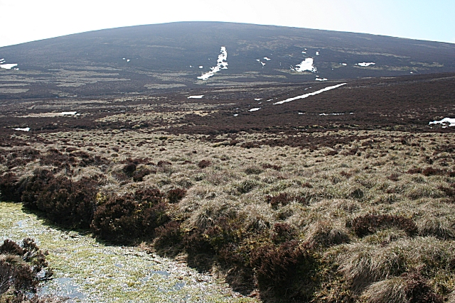
Badenshore Moss is a picturesque area located in Aberdeenshire, Scotland. Nestled amongst the rolling hills of the Downs region, it is a stunning example of moorland landscape. Spanning over a vast area, Badenshore Moss is known for its unique and diverse ecosystem.

The moss is predominantly composed of peat, which provides a rich habitat for a variety of flora and fauna. The area is covered with heather, cotton grass, and various moss species, creating a vibrant and colorful scenery. The moss is also home to a number of rare and endangered plant species, making it an important site for conservation.

The wildlife in Badenshore Moss is equally impressive. The moorland provides a habitat for several bird species, including the iconic red grouse, curlew, and lapwing. These birds can often be spotted soaring through the skies or nesting on the ground. The moss is also inhabited by various mammals, such as red deer and mountain hares, which roam freely through the open landscape.

The moss is a popular destination for nature enthusiasts and hikers, who can explore the area through well-maintained walking trails. The breathtaking views of the surrounding hills and valleys make it a favorite spot for photographers and painters alike.

Badenshore Moss is not only a beautiful natural landscape but also an important site for preserving biodiversity and supporting local wildlife. It offers a tranquil escape from the bustling city life, allowing visitors to immerse themselves in the peacefulness and serenity of nature.

If you have any feedback on the listing, please let us know in the comments section below.

Badenshore Moss Images

Images are sourced within 2km of 57.263943/-2.987405 or Grid Reference NJ4019. Thanks to Geograph Open Source API. All images are credited.

Abandoned cottage at Largue Derelict and decaying house in upper Glen Kindie.
Abandoned cottage at Largue
Derelict and decaying house in upper Glen Kindie.
Track to Largue One of several abandoned houses at the head of Glen Kindie.
Track to Largue
One of several abandoned houses at the head of Glen Kindie.
Abandoned farm steading at Tollafraick A rusty-roofed outbuilding at this old hill farm.
Abandoned farm steading at Tollafraick
A rusty-roofed outbuilding at this old hill farm.
Looking over the moor towards the Burn of Cross
This tiny burn is carving out a valley in the boulder clay
Burn draining the moor to the west of Mount Meddin The erosion is revealing the rocks in the boulder clay
Burn draining the moor to the west of Mount Meddin
The erosion is revealing the rocks in the boulder clay
Heather Moor There's not a lot up here on the moors at the moment except dormant heather, snow and Red Grouse. The skyline is the slope of Dun Mount.
Heather Moor
There's not a lot up here on the moors at the moment except dormant heather, snow and Red Grouse. The skyline is the slope of Dun Mount.
Moorland Track This is one of the very few lengths of track in this square. One of its ruts has also become a burn, draining the melting snowdrift above.
Moorland Track
This is one of the very few lengths of track in this square. One of its ruts has also become a burn, draining the melting snowdrift above.
Moorland Hills This square is entirely heather moor, and the maps suggest that it is almost trackless. The skyline is White Knowe, a continuation to the north of Craig an Eunan, which is out of view to the left.
Moorland Hills
This square is entirely heather moor, and the maps suggest that it is almost trackless. The skyline is White Knowe, a continuation to the north of Craig an Eunan, which is out of view to the left.
Blind Burn The Blind Burn drains the north-east slope of Creag an Eunan, marked by the long drift of snow almost in line with the summit (633 metres). The burn is in square but not the summit, which is in <a href="https://www.geograph.org.uk/gridref/NJ3819">NJ3819</a>. The map suggests that the bright green cut at my feet might be a track, but I decided not to risk it actually being a bog.
Blind Burn
The Blind Burn drains the north-east slope of Creag an Eunan, marked by the long drift of snow almost in line with the summit (633 metres). The burn is in square but not the summit, which is in NJ3819. The map suggests that the bright green cut at my feet might be a track, but I decided not to risk it actually being a bog.
Looking towards White Knowe White Knowe is a northern extension of Craig an Eunan, and it is just out of square in <a href="https://www.geograph.org.uk/gridref/NJ3819">NJ3819</a>. The whole of this square is rolling heather moor. The map suggests that the bright green cut at my feet might be a track, but I decided not to risk it actually being a bog.
Looking towards White Knowe
White Knowe is a northern extension of Craig an Eunan, and it is just out of square in NJ3819. The whole of this square is rolling heather moor. The map suggests that the bright green cut at my feet might be a track, but I decided not to risk it actually being a bog.
Ford no more! The map suggests that this is a ford, but if so, it is an ex-ford, because the water has carried away a few chunks of it at this end, just below where I am standing. Despite this, it was easy to cross dryshod, because the grassy ridges are quite firm.
Ford no more!
The map suggests that this is a ford, but if so, it is an ex-ford, because the water has carried away a few chunks of it at this end, just below where I am standing. Despite this, it was easy to cross dryshod, because the grassy ridges are quite firm.
Midstrone Burn Not only is the burn in this declivity unnamed on the 1:50,000 and 1:25,000 maps, it is barely even marked at all. However it is named on the Victorian six-inch map. It drains the Dun Mount, which is on the skyline.
Midstrone Burn
Not only is the burn in this declivity unnamed on the 1:50,000 and 1:25,000 maps, it is barely even marked at all. However it is named on the Victorian six-inch map. It drains the Dun Mount, which is on the skyline.
The Slopes of Meikle Clachdubh Meikle Clachdubh is a continuation of Creag an Eunan to the east. Meikle is Scots and means 'large' while 'clach' and 'dubh' are Gaelic, meaning 'stone' and 'dark' respectively.
The Slopes of Meikle Clachdubh
Meikle Clachdubh is a continuation of Creag an Eunan to the east. Meikle is Scots and means 'large' while 'clach' and 'dubh' are Gaelic, meaning 'stone' and 'dark' respectively.
Above Leochrie Looking up from Leochrie into the corrie where the headwaters of the Sluggan Burn rise. The linear excavation is a drainage ditch which channels the water into <a href="https://www.geograph.org.uk/photo/1803647">NJ3917 : Old Pond at Leochrie</a>. The skyline is the spur of Craig an Eunan which becomes first Meikle then Little Clachdubh. High up in the corrie, muirburning is producing a plume of smoke. Burning is permitted above 450 metres until 30 April, and is an essential part of managing the moors for grouse.
Above Leochrie
Looking up from Leochrie into the corrie where the headwaters of the Sluggan Burn rise. The linear excavation is a drainage ditch which channels the water into NJ3917 : Old Pond at Leochrie. The skyline is the spur of Craig an Eunan which becomes first Meikle then Little Clachdubh. High up in the corrie, muirburning is producing a plume of smoke. Burning is permitted above 450 metres until 30 April, and is an essential part of managing the moors for grouse.
Old Pond at Leochrie This is marked on the 1:25,000 map as a pond, but it is almost dry, even now when the snow is thawing. It drains at the far end through a pipe and is led past the end of the nearest building, which makes me think that it must have powered a mill at one time.
Old Pond at Leochrie
This is marked on the 1:25,000 map as a pond, but it is almost dry, even now when the snow is thawing. It drains at the far end through a pipe and is led past the end of the nearest building, which makes me think that it must have powered a mill at one time.
Ruined Mill at Leochrie The water from <a href="https://www.geograph.org.uk/photo/1803647">NJ3917 : Old Pond at Leochrie</a> flows close past the wall of this building, so I think it must have been some sort of mill.
Ruined Mill at Leochrie
The water from NJ3917 : Old Pond at Leochrie flows close past the wall of this building, so I think it must have been some sort of mill.
Tollafraick Hill farm.
Tollafraick
Hill farm.
Show me another place!

Badenshore Moss is located at Grid Ref: NJ4019 (Lat: 57.263943, Lng: -2.987405)

Unitary Authority: Aberdeenshire

Police Authority: North East

What 3 Words

///denoting.sizing.munched. Near Alford, Aberdeenshire

Nearby Locations

Badenshore Moss

Related Wikis

Grampian

Grampian (Scottish Gaelic: Roinn a' Mhonaidh) was one of nine former local government regions of Scotland created in 1975 by the Local Government (Scotland...

Glenbuchat Castle

Glenbuchat Castle is a historic Z plan Scottish castle built in 1590 for John Gordon of Cairnbarrow to mark his wedding. It is located above the River...

Peatfold Burn

Peatfold Burn is a burn which marks the boundary of the parish of Huntly, Aberdeenshire, Scotland. == References ==

Clova Monastery

Clova Monastery (also called Cloveth) was a medieval Culdee monastery in Kildrummy, Aberdeenshire, Scotland. == Founding == Clova was founded in the late...

Have you been to Badenshore Moss?

Leave your review of Badenshore Moss below (or comments, questions and feedback).