Baildon Wood Bottom

Settlement in Yorkshire

England

Baildon Wood Bottom

Enclosed paved Bridleway leaving Baildon for Hawksworth or Guiseley Looking eastward.
Enclosed paved Bridleway leaving Baildon for Hawksworth or Guiseley Credit: Peter Wood

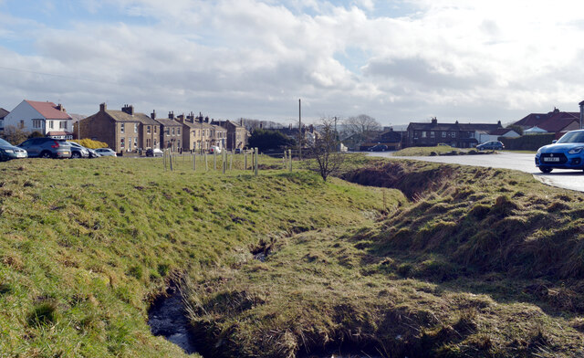
Baildon Wood Bottom is a picturesque village located in the county of Yorkshire, England. Nestled in the heart of the Baildon Moor, this charming settlement offers a tranquil retreat from the bustling city life.

Surrounded by lush greenery and rolling hills, Baildon Wood Bottom boasts a remarkable natural beauty. The area is characterized by dense woodlands, giving it a sense of seclusion and tranquility. The village is dotted with quaint cottages and traditional stone-built houses, adding to its idyllic charm.

One of the main attractions in Baildon Wood Bottom is the Baildon Moor, a vast expanse of open heather moorland that stretches for miles. This area is a haven for nature enthusiasts, offering a wide range of flora and fauna to explore. Visitors can enjoy leisurely walks or bike rides along the numerous trails, taking in the stunning views of the surrounding countryside.

The village is also home to several historic landmarks, including the Baildon Moor Trig Point, which serves as a reference point for surveying the landscape. Additionally, the nearby Baildon Green and St. James' Church provide glimpses into the area's rich history.

Baildon Wood Bottom offers a peaceful lifestyle, with a strong sense of community. The village is well-served by local amenities, including a primary school, shops, and a pub, catering to the needs of its residents.

Overall, Baildon Wood Bottom is a charming village that combines natural beauty, historical significance, and a close-knit community, making it an ideal destination for those seeking a serene retreat in the heart of Yorkshire.

If you have any feedback on the listing, please let us know in the comments section below.

Baildon Wood Bottom Images

Images are sourced within 2km of 53.840634/-1.768812 or Grid Reference SE1538. Thanks to Geograph Open Source API. All images are credited.

Enclosed paved Bridleway leaving Baildon for Hawksworth or Guiseley Looking eastward.
Enclosed paved Bridleway leaving Baildon for Hawksworth or Guiseley
Looking eastward.
The Shroggs Snooker & Social Club, Baildon Situated on the edge of Baildon Moor.
The Shroggs Snooker & Social Club, Baildon
Situated on the edge of Baildon Moor.
Road Junction on Baildon Moor This is the junction of Hawksworth Road (straight ahead) & Bingley Road (off left). The stone post has a very damaged OS Cut Benchmark on it, where the light patch is.
Road Junction on Baildon Moor
This is the junction of Hawksworth Road (straight ahead) & Bingley Road (off left). The stone post has a very damaged OS Cut Benchmark on it, where the light patch is.
Baildon Golf Club This clubhouse is the converted Baildon Waterworks building. The building was purchased by the club in 1994 and was opened in January 2019.
Baildon Golf Club
This clubhouse is the converted Baildon Waterworks building. The building was purchased by the club in 1994 and was opened in January 2019.
The Millennium Way running alongside Hawksworth Road, Baildon Moor
Golf course, Baildon Moor The first tee of Baildon Golf Club's course.
Golf course, Baildon Moor
The first tee of Baildon Golf Club's course.
Footpath between Hawksworth Road and Baildon Trig Point, Baildon Moor
Footpath between Baildon Trig Point and  Hawksworth Road, Baildon Moor
Footpath between Baildon Trig Point and Hawksworth Road, Baildon Moor
Baildon Golf Club This clubhouse is the converted Baildon Waterworks building. The building was purchased by the club in 1994 and was opened in January 2019.
Baildon Golf Club
This clubhouse is the converted Baildon Waterworks building. The building was purchased by the club in 1994 and was opened in January 2019.
Stream leaving Baildon Moor
Cattle grid on Hawksworth Road as it leaves Baildon to cross Baildon Moor
Looking down Ladderbanks Lane A public bridleway, stone surfaced in places.
Looking down Ladderbanks Lane
A public bridleway, stone surfaced in places.
Merville Avenue - Brantcliffe Drive
Brantcliffe Way - Brantcliffe Drive
Baildon Golf Club House
The Shroggs Private Club
Hawksworth Road - Over the Moors & Far Away!
Footpath - Hawksworth Road
Show me another place!

Baildon Wood Bottom is located at Grid Ref: SE1538 (Lat: 53.840634, Lng: -1.768812)

Division: West Riding

Unitary Authority: Bradford

Police Authority: West Yorkshire

What 3 Words

///resist.trial.plank. Near Shipley, West Yorkshire

Related Wikis

Bradford Beck

Bradford Beck is a river that flows through Bradford, West Yorkshire, England, (then Bradford Dale) and on to the River Aire at Shipley. As it reaches...

Shipley and Windhill railway station

Shipley and Windhill railway station was a railway station in Shipley, West Yorkshire, England between 1875 and 1931. During the 1860s, two small railway...

Shipley railway station

Shipley railway station serves the market town of Shipley in West Yorkshire, England. It is 2+3⁄4 miles (4.4 km) north of Bradford Forster Square and 10...

Shipley, West Yorkshire

Shipley is a historic market town and civil parish in the City of Bradford, West Yorkshire, England, by the River Aire and the Leeds and Liverpool Canal...

Nearby Amenities

Located within 500m of 53.840634,-1.768812
Traffic Signals
Lat/Long: 53.8398108/-1.7693883
Crossing
Crossing: unmarked
Crossing Island: no
Tactile Paving: no
Lat/Long: 53.8371547/-1.7670655
Railway: switch
Lat/Long: 53.8365271/-1.766622
Source: landsat
Lat/Long: 53.8408651/-1.7753295
Source: landsat
Lat/Long: 53.8399281/-1.7754006
Source: landsat
Lat/Long: 53.8444136/-1.7726975
Source: landsat
Lat/Long: 53.8440299/-1.7724138
Source: landsat
Lat/Long: 53.8430551/-1.7722428
Source: landsat
Lat/Long: 53.84312/-1.7712965
Source: landsat
Lat/Long: 53.8428038/-1.7702032
Source: landsat
Lat/Long: 53.8423356/-1.7688109
Source: landsat
Lat/Long: 53.8428719/-1.7680921
Source: landsat
Lat/Long: 53.8416759/-1.7657798
Source: landsat
Lat/Long: 53.8385357/-1.7725626
Source: landsat
Lat/Long: 53.8388825/-1.7730901
Source: landsat
Lat/Long: 53.8394149/-1.7730395
Source: landsat
Lat/Long: 53.8395624/-1.7757262
Source: landsat
Lat/Long: 53.8443202/-1.7709788
Source: landsat
Lat/Long: 53.8448984/-1.7707007
Source: landsat
Lat/Long: 53.8445275/-1.7691677
Source: landsat
Lat/Long: 53.8449029/-1.7674482
Source: landsat
Lat/Long: 53.8448715/-1.7668784
Source: landsat
Lat/Long: 53.8440414/-1.7672877
Source: landsat
Lat/Long: 53.8425698/-1.7637429
Bus Stop
Otley Road Midland Road
Bench: yes
Bin: no
Bus: yes
Lit: yes
Local Ref: 45018856
Naptan AtcoCode: 450018856
Naptan Bearing: SW
Naptan CommonName: Otley Road Midland Road
Naptan Crossing: Midland Road
Naptan Indicator: Stop 45018856
Naptan Landmark: Woodbottom Post Office
Naptan Notes: OSR taken place 170805
Naptan PlusbusZoneRef: LEEDS
Naptan ShortCommonName: Midland Road
Naptan Street: Otley Road
Public Transport: platform
Shelter: yes
Source: naptan_import;survey
Tactile Paving: no
Lat/Long: 53.842508/-1.7634837
Bus Stop
Otley Road Woodcot Avenue
Bench: yes
Bin: no
Bus: yes
Lit: yes
Local Ref: 45018857
Naptan AtcoCode: 450018857
Naptan Bearing: NE
Naptan CommonName: Otley Road Woodcot Avenue
Naptan Crossing: Woodcot Avenue
Naptan Indicator: Stop 45018857
Naptan PlusbusZoneRef: LEEDS
Naptan ShortCommonName: Woodcot Avenue
Naptan Street: Otley Road
Public Transport: platform
Shelter: yes
Source: naptan_import;survey
Tactile Paving: no
Lat/Long: 53.8422057/-1.7646704
Bus Stop
Otley Road John Street
Bench: no
Bin: no
Bus: yes
Lit: yes
Local Ref: 45018858
Naptan AtcoCode: 450018858
Naptan Bearing: NE
Naptan CommonName: Otley Road John Street
Naptan Crossing: Adj John Street
Naptan Indicator: Stop 45018858
Naptan Landmark: Unknown
Naptan PlusbusZoneRef: LEEDS
Naptan ShortCommonName: Albert Street
Naptan Street: Otley Road
Naptan Verified: no
Public Transport: platform
Shelter: no
Source: naptan_import
Tactile Paving: no
Lat/Long: 53.8411214/-1.7668351
Bus Stop
Otley Road Wood Street
Bench: no
Bin: no
Bus: yes
Lit: yes
Local Ref: 45018859
Naptan AtcoCode: 450018859
Naptan Bearing: SW
Naptan CommonName: Otley Road Wood Street
Naptan Crossing: Wood Street
Naptan Indicator: Stop 45018859
Naptan Landmark: Baildon Holmes Industrial Estate
Naptan PlusbusZoneRef: LEEDS
Naptan ShortCommonName: Wood Street
Naptan Street: Otley Road
Naptan Verified: no
Public Transport: platform
Shelter: no
Source: naptan_import
Tactile Paving: no
Lat/Long: 53.8406014/-1.767537
Bus Stop
Otley Road Dockfield Road
Local Ref: 45018860
Naptan AtcoCode: 450018860
Naptan Bearing: S
Naptan CommonName: Otley Road Dockfield Road
Naptan Crossing: Nr-At Dockfield Road
Naptan Indicator: Stop 45018860
Naptan Landmark: Cricket Ground
Naptan PlusbusZoneRef: LEEDS
Naptan ShortCommonName: Dockfield Road
Naptan Street: Otley Road
Naptan Verified: no
Shelter: no
Source: naptan_import
Lat/Long: 53.8374571/-1.7730252
Bus Stop
Otley Road Green Lane
Bench: yes
Bin: no
Lit: yes
Local Ref: 45018861
Naptan AtcoCode: 450018861
Naptan Bearing: N
Naptan CommonName: Otley Road Green Lane
Naptan Crossing: Green Lane
Naptan Indicator: Stop 45018861
Naptan Landmark: Cricket Ground
Naptan Notes: OSR taken place 120805
Naptan PlusbusZoneRef: LEEDS
Naptan ShortCommonName: Green Lane
Naptan Street: Otley Road
Naptan Verified: no
Shelter: yes
Source: naptan_import
Tactile Paving: no
Lat/Long: 53.8379155/-1.7730974
Bus Stop
Green Lane Cliffe Lane
Local Ref: 45018862
Naptan AtcoCode: 450018862
Naptan Bearing: E
Naptan CommonName: Green Lane Cliffe Lane
Naptan Crossing: Cliffe Lane
Naptan Indicator: Stop 45018862
Naptan Landmark: Cricket Ground
Naptan PlusbusZoneRef: LEEDS
Naptan ShortCommonName: Cliffe Lane
Naptan Street: Green Lane
Naptan Verified: no
Source: naptan_import
Lat/Long: 53.8387099/-1.7740402
Bus Stop
Knoll Estate The Crescent
Bus: yes
Local Ref: 45018886
Naptan AtcoCode: 450018886
Naptan Bearing: SW
Naptan CommonName: Knoll Estate The Crescent
Naptan Crossing: The Crescent
Naptan Indicator: Stop 45018886
Naptan PlusbusZoneRef: LEEDS
Naptan ShortCommonName: The Crescent
Naptan Street: Denby Drive
Naptan Verified: no
Public Transport: platform
Source: naptan_import
Lat/Long: 53.8424901/-1.772846
Bus Stop
The Crescent Central Avenue
Bus: yes
Local Ref: 45018887
Naptan AtcoCode: 450018887
Naptan Bearing: N
Naptan CommonName: The Crescent Central Avenue
Naptan Crossing: Central Avenue
Naptan Indicator: Stop 45018887
Naptan PlusbusZoneRef: LEEDS
Naptan ShortCommonName: Central Avenue
Naptan Street: The Crescent
Naptan Verified: no
Public Transport: platform
Source: naptan_import
Lat/Long: 53.843084/-1.7731924
Bus Stop
Denby Drive Southlands
Local Ref: 45018888
Naptan AtcoCode: 450018888
Naptan Bearing: E
Naptan CommonName: Denby Drive Southlands
Naptan Crossing: Southlands
Naptan Indicator: Stop 45018888
Naptan PlusbusZoneRef: LEEDS
Naptan ShortCommonName: Southlands
Naptan Street: Denby Drive
Naptan Verified: no
Source: naptan_import
Lat/Long: 53.8416849/-1.7748413
Bus Stop
Denby Drive Southlands
Local Ref: 45018889
Naptan AtcoCode: 450018889
Naptan Bearing: W
Naptan CommonName: Denby Drive Southlands
Naptan Crossing: Southlands
Naptan Indicator: Stop 45018889
Naptan PlusbusZoneRef: LEEDS
Naptan ShortCommonName: Southlands
Naptan Street: Denby Drive
Naptan Verified: no
Source: naptan_import
Lat/Long: 53.8415599/-1.7752675
Bus Stop
Baildon Road Wood Street
Bus: yes
Local Ref: 45018895
Naptan AtcoCode: 450018895
Naptan Bearing: SW
Naptan CommonName: Baildon Road Wood Street
Naptan Crossing: Wood Street
Naptan Indicator: Stop 45018895
Naptan PlusbusZoneRef: LEEDS
Naptan ShortCommonName: Wood Street
Naptan Street: Baildon Road
Naptan Verified: no
Public Transport: platform
Source: naptan_import
Lat/Long: 53.8410074/-1.7683099
Bus Stop
Baildon Road Rockcliffe Avenue
Bus: yes
Local Ref: 45018896
Naptan AtcoCode: 450018896
Naptan Bearing: NE
Naptan CommonName: Baildon Road Rockcliffe Avenue
Naptan Crossing: Rockcliffe Avenue
Naptan Indicator: Stop 45018896
Naptan PlusbusZoneRef: LEEDS
Naptan ShortCommonName: Rockcliffe Avenue
Naptan Street: Baildon Road
Naptan Verified: no
Public Transport: platform
Source: naptan_import
Lat/Long: 53.8414923/-1.7680792
Bus Stop
Baildon Road Rockcliffe Avenue
Bus: yes
Local Ref: 45018897
Naptan AtcoCode: 450018897
Naptan Bearing: NE
Naptan CommonName: Baildon Road Rockcliffe Avenue
Naptan Indicator: Stop 45018897
Naptan Landmark: Church
Naptan PlusbusZoneRef: LEEDS
Naptan ShortCommonName: Baildon Road
Naptan Street: Baildon Road
Naptan Verified: no
Public Transport: platform
Source: naptan_import
Lat/Long: 53.8429279/-1.7667642
Bus Stop
Baildon Road Oak Bank
Bus: yes
Local Ref: 45018898
Naptan AtcoCode: 450018898
Naptan Bearing: S
Naptan CommonName: Baildon Road Oak Bank
Naptan Crossing: Nr-At Oak Bank
Naptan Indicator: Stop 45018898
Naptan Landmark: Church
Naptan PlusbusZoneRef: LEEDS
Naptan ShortCommonName: Baildon Road
Naptan Street: Baildon Road
Naptan Verified: no
Public Transport: platform
Source: naptan_import
Lat/Long: 53.8431789/-1.7664437
Bus Stop
Green Lane Cliffe Lane
Local Ref: 45025921
Naptan AtcoCode: 450025921
Naptan Bearing: W
Naptan CommonName: Green Lane Cliffe Lane
Naptan Crossing: Cliffe Lane
Naptan Indicator: Stop 45025921
Naptan Landmark: Cricket Ground
Naptan PlusbusZoneRef: LEEDS
Naptan ShortCommonName: Cliffe Lane
Naptan Street: Green Lane
Naptan Verified: no
Source: naptan_import
Lat/Long: 53.8386092/-1.7739156
Bus Stop
Otley Road Baildon Road
Bench: no
Bin: no
Bus: yes
Lit: yes
Local Ref: 45027447
Naptan AtcoCode: 450027447
Naptan Bearing: SW
Naptan CommonName: Otley Road Baildon Road
Naptan Crossing: Baildon Road
Naptan Indicator: Stop 45027447
Naptan Landmark: Focus DIY
Naptan PlusbusZoneRef: LEEDS
Naptan ShortCommonName: Baildon Road
Naptan Street: Otley Road
Naptan Verified: no
Public Transport: platform
Shelter: no
Source: naptan_import
Tactile Paving: no
Lat/Long: 53.8390797/-1.7707977
Bus Stop
Otley Road Bailldon Road
Bus: yes
Local Ref: 45027448
Naptan AtcoCode: 450027448
Naptan Bearing: NE
Naptan CommonName: Otley Road Bailldon Road
Naptan Crossing: Baildon Road
Naptan Indicator: Stop 45027448
Naptan Landmark: Fous DIY
Naptan PlusbusZoneRef: LEEDS
Naptan ShortCommonName: Baildon Road
Naptan Street: Otley Road
Naptan Verified: no
Public Transport: platform
Shelter: no
Source: naptan_import
Lat/Long: 53.8394563/-1.7703245
Barrier: bollard
Bicycle: yes
Bollard: fixed
Foot: yes
Horse: no
Material: concrete
Motor Vehicle: no
Source: local knowledge
Lat/Long: 53.8395577/-1.7761477
Information: route_marker
Tourism: information
Lat/Long: 53.8424714/-1.7624121
Turning Circle
Lat/Long: 53.8445042/-1.7715466
Turning Circle
Lat/Long: 53.8426041/-1.7654722
Post Box
Operator: Royal Mail
Post Box Type: pillar
Royal Cypher: GVIR
Royal Cypher Wikidata: Q33102169
Lat/Long: 53.8386922/-1.7739378
Leisure: swimming_pool
Sport: swimming
Lat/Long: 53.841356/-1.764356
Restaurant
Sun Sing
Addr City: Shipley
Addr Housenumber: 1-3 Baildon Bridge
Addr Postcode: BD17 7EP
Addr Street: Otley Road
Addr Village: Baildon
Cuisine: chinese
Fhrs Id: 327343
Source Addr: FHRS Open Data
Lat/Long: 53.8383186/-1.7729919
Restaurant
San Angelo
Addr City: Shipley
Addr Housenumber: 22
Addr Postcode: BD17 7HB
Addr Street: Otley Road
Addr Village: Baildon
Cuisine: italian
Fhrs Id: 327769
Image: https://www.geograph.org.uk/photo/2574233
Source Addr: FHRS
Lat/Long: 53.8406041/-1.7680232
Cafe
Pit Stop Cafe
Addr City: Shipley
Addr Housenumber: 8
Addr Postcode: BD17 6AA
Addr Street: Queen Street
Addr Village: Baildon
Fhrs Id: 324926
Lat/Long: 53.8407367/-1.7682212
Baildon Motors
Addr City: Shipley
Addr Village: Baildon
Shop: car_repair
Lat/Long: 53.8408475/-1.7683392
Shop: motorcycle
Lat/Long: 53.8408979/-1.7665242
Cutting Edge
Shop: hairdresser
Lat/Long: 53.8404045/-1.7684303
Railway: switch
Lat/Long: 53.8364795/-1.7667336
Turning Circle
Lat/Long: 53.8450041/-1.7685833
Traffic Signals
Traffic Signals Direction: forward
Lat/Long: 53.8384664/-1.7725042
Crossing
Crossing: traffic_signals
Crossing Island: no
Crossing Ref: pelican
Tactile Paving: yes
Lat/Long: 53.8423919/-1.7639964
Telephone
Booth: K6
Covered: booth
Image: https://www.geograph.org.uk/photo/2983304
Man Made: telephone_box
Lat/Long: 53.8400542/-1.7691047
Parking
Parking: surface
Lat/Long: 53.8405773/-1.7683911
Parking
Lat/Long: 53.8421157/-1.76328
Atm
Lat/Long: 53.8412635/-1.7659216
Parking
Parking: surface
Surface: asphalt
Lat/Long: 53.8374106/-1.7736384
Charlestown and Low Baildon Information Board
Information: board
Tourism: information
Lat/Long: 53.842294/-1.7644495
Baildon Parish Council Information Board
Information: board
Tourism: information
Lat/Long: 53.8421807/-1.7647283
Welcome To Baildon
Information: guidepost
Tourism: information
Lat/Long: 53.8374946/-1.7732858
Fast Food
Crusty's Takeaway
Addr City: Shipley
Addr Housenumber: 54B
Addr Postcode: BD17 7HH
Addr Street: Otley Road
Addr Village: Baildon
Cuisine: sandwich
Fhrs Id: 327761
Source Addr: FHRS Open Data
Lat/Long: 53.8426798/-1.7640067
The Hair Lounge
Shop: hairdresser
Lat/Long: 53.8426486/-1.764073
Restaurant
Happy House
Addr City: Shipley
Addr Housenumber: 52
Addr Postcode: BD17 7HH
Addr Street: Otley Road
Addr Village: Baildon
Cuisine: chinese
Fhrs Id: 327760
Image: https://www.geograph.org.uk/photo/2574192
Source Addr: FHRS Open Data
Lat/Long: 53.8426228/-1.7641381
Hopes News
Addr City: Shipley
Addr Housenumber: 48
Addr Postcode: BD17 7HH
Addr Street: Otley Road
Brand: Mace
Brand Wikidata: Q75240338
Brand Wikipedia: en:Mace (shop)
Fhrs Id: 327767
Shop: convenience
Lat/Long: 53.8425465/-1.7642984
MB Trading
Addr City: Shipley
Addr Housenumber: 50
Addr Postcode: BD17 7HH
Addr Street: Otley Road
Shop: doityourself
Source Addr: website
Website: https://www.mbdiscounttools.co.uk/
Lat/Long: 53.8425924/-1.7642118
Cafe
The Cafe Break
Lat/Long: 53.8425231/-1.764346
Barbershop
Male: yes
Old Name: Stylistics
Shop: hairdresser
Website: http://www.barbershopbaildon.com/#home
Lat/Long: 53.8425014/-1.7644077
Baildon Green Convenience Store
Addr City: Shipley
Addr Housenumber: 38-42
Addr Postcode: BD17 5QP
Addr Street: Cliffe Lane West
Addr Village: Baildon
Fhrs Id: 327439
Shop: convenience
Source Addr: FHRS Open Data
Lat/Long: 53.8426932/-1.772371
Parking
Lat/Long: 53.8385923/-1.7730343
Post Box
Image: https://www.geograph.org.uk/photo/6743519
Operator: Royal Mail
Operator Wikidata: Q638098
Ref: BD17 951
Royal Cypher: EIIR
Royal Cypher Wikidata: Q33102113
Lat/Long: 53.8409936/-1.7670589
Direction East: Leeds 12.25
Direction West: Liverpool 115
Waterway: milestone
Lat/Long: 53.8396056/-1.7629798
Barrier: yes
Lat/Long: 53.8375808/-1.7671713
Information: route_marker
Tourism: information
Lat/Long: 53.8427798/-1.7626511
Post Box
Operator: Royal Mail
Post Box Type: lamp
Royal Cypher: EIIR
Royal Cypher Wikidata: Q33102113
Lat/Long: 53.8428004/-1.7753323
Post Box
Operator: Royal Mail
Operator Wikidata: Q638098
Post Box Type: pillar
Royal Cypher: EIIR
Royal Cypher Wikidata: Q33102113
Lat/Long: 53.8368883/-1.7724782
Shipley Dockfield Junction
Railway: junction
Lat/Long: 53.8368446/-1.7658041
Parking
Lat/Long: 53.8363739/-1.7676365
Parking
Lat/Long: 53.8362366/-1.769706
Fixme: Does this join road?
Lat/Long: 53.8387094/-1.7747268
Generator Method: photovoltaic
Generator Output Electricity: yes
Generator Source: solar
Generator Type: solar_photovoltaic_panel
Power: generator
Lat/Long: 53.840726/-1.7751553
Generator Method: photovoltaic
Generator Output Electricity: yes
Generator Source: solar
Generator Type: solar_photovoltaic_panel
Power: generator
Lat/Long: 53.8410253/-1.7745277
Generator Method: photovoltaic
Generator Output Electricity: yes
Generator Source: solar
Generator Type: solar_photovoltaic_panel
Power: generator
Lat/Long: 53.8412954/-1.7735981
Generator Method: photovoltaic
Generator Output Electricity: yes
Generator Source: solar
Generator Type: solar_photovoltaic_panel
Power: generator
Lat/Long: 53.8418486/-1.7673181
Parking
Access: customers
Parking: surface
Lat/Long: 53.8417887/-1.767823
Generator Method: photovoltaic
Generator Output Electricity: yes
Generator Source: solar
Generator Type: solar_photovoltaic_panel
Power: generator
Lat/Long: 53.8410382/-1.7653593
Barrier: cycle_barrier
Material: metal
Lat/Long: 53.8443969/-1.7727275
Waste Basket
Lat/Long: 53.8444169/-1.7726917
Bicycle Parking
Access: customers
Bicycle Parking: stands
Covered: yes
Fee: no
Operator: Saltaire Brewery
Operator Type: business
Lat/Long: 53.8384711/-1.7661834
Traffic Signals
Traffic Signals Direction: backward
Lat/Long: 53.8383351/-1.772674
Traffic Signals
Traffic Signals Direction: backward
Lat/Long: 53.8384467/-1.7726639
Curl Up & Di
Shop: hairdresser
Lat/Long: 53.8374077/-1.7734786
Medusa Stoves
Addr City: Shipley
Addr Housenumber: 2/4
Addr Postcode: BD17 5JS
Addr Street: Green Lane
Shop: fireplace
Website: https://www.medusastoves.co.uk/index.php
Lat/Long: 53.8383941/-1.7729737
Crossing
Crossing: traffic_signals
Tactile Paving: yes
Lat/Long: 53.8397207/-1.7692436
On the Lash
Addr City: Shipley
Addr Housenumber: 69
Addr Postcode: BD17 7EP
Addr Street: Baildon Bridge
Shop: beauty
Website: https://www.onthelashbaildon.co.uk/
Lat/Long: 53.8374318/-1.7734323
Slingsby
Addr City: Shipley
Addr Postcode: BD17 7LW
Addr Street: Otley Road
Office: company
Website: https://www.slingsby.com/
Lat/Long: 53.8399878/-1.7672619
Inspired Carpets & Bed Centre
Addr City: Shipley
Addr Postcode: BD17 7EX
Shop: carpet
Website: https://inspiredcarpets.co.uk/
Lat/Long: 53.8385824/-1.7712021
Bench
Lat/Long: 53.8422727/-1.7645415
Crossing
Crossing: unmarked
Crossing Island: yes
Kerb: flush
Tactile Paving: yes
Lat/Long: 53.8417107/-1.7655659
Crossing
Crossing: unmarked
Crossing Island: yes
Lat/Long: 53.8410687/-1.766803
Man Made: chimney
Lat/Long: 53.8363714/-1.7689054
Entrance: yes
Lat/Long: 53.8372818/-1.7704106
Post Box
Image: https://www.geograph.org.uk/photo/2574197
Post Box Type: pillar
Lat/Long: 53.8425493/-1.7641586
Waste Basket
Lat/Long: 53.8371967/-1.7670303
Direction East: Apperley Bridge 1 hour 10 mins
Direction West: Saltaire 24 mins
Information: guidepost
Tourism: information
Lat/Long: 53.8373795/-1.766762
Information: route_marker
Tourism: information
Lat/Long: 53.8398565/-1.7622353
Bench
Lat/Long: 53.8395938/-1.7630226
Information: guidepost
Tourism: information
Lat/Long: 53.8371628/-1.7670259
Information: route_marker
Tourism: information
Lat/Long: 53.8365423/-1.7668033
The data included in this document is from www.openstreetmap.org. The data is made available under ODbL.

Have you been to Baildon Wood Bottom?

Leave your review of Baildon Wood Bottom below (or comments, questions and feedback).