Victoria Common
Downs, Moorland in Herefordshire
England
Victoria Common

Victoria Common is a picturesque area located in Herefordshire, England. It is renowned for its stunning landscapes comprised of downs and moorland. The common covers a vast area, spanning several miles, and is a popular destination for nature enthusiasts and hikers.
The downs in Victoria Common are characterized by their rolling hills and lush green fields. These open spaces offer breathtaking views of the surrounding countryside and are home to a diverse range of flora and fauna. Visitors can spot various species of wildflowers, including orchids and heather, creating a vibrant and colorful atmosphere during the summer months.
The moorland in Victoria Common is a unique feature of the area, providing a stark contrast to the downs. It is characterized by its rugged terrain, with areas of marshes and peat bogs interspersed with patches of heather and gorse. The moorland is also home to a variety of wildlife, such as rare bird species like the curlew and lapwing, as well as small mammals like the hare and stoat.
The common offers numerous walking trails and paths, catering to both experienced hikers and casual walkers. These routes allow visitors to explore the diverse landscapes and take in the stunning views. Additionally, there are designated picnic areas and benches where visitors can relax and enjoy the tranquility of the surroundings.
Overall, Victoria Common in Herefordshire is a natural haven, offering a unique blend of downs and moorland. Its breathtaking landscapes, diverse wildlife, and well-maintained trails make it a must-visit destination for nature lovers and outdoor enthusiasts.
If you have any feedback on the listing, please let us know in the comments section below.
Victoria Common Images
Images are sourced within 2km of 52.011776/-2.9865971 or Grid Reference SO3235. Thanks to Geograph Open Source API. All images are credited.


Victoria Common is located at Grid Ref: SO3235 (Lat: 52.011776, Lng: -2.9865971)
Unitary Authority: County of Herefordshire
Police Authority: West Mercia
What 3 Words
///hotel.masses.boomers. Near Turnastone, Herefordshire
Related Wikis

Ewyas Lacy
Ewyas Lacy was an ancient hundred in south-west Herefordshire. It was part of the ancient Welsh region of Ewyas claimed by the de Lacy family following...

Michaelchurch Escley
Michaelchurch Escley is a village and civil parish 13 miles (21 km) west of Hereford, in the county of Herefordshire, England. In 2011 the parish had a...
Welsh Marches
The Welsh Marches (Welsh: Y Mers) is an imprecisely defined area along the border between England and Wales in the United Kingdom. The precise meaning...

Urishay Castle
Urishay constitutes the remains of a castle, 16th century chapel and 17th century house located about 2.5 km west of Peterchurch in Herefordshire, England...
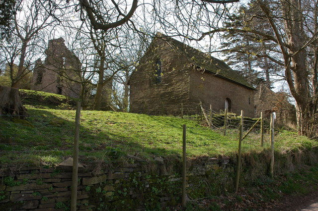
Urishay Castle Chapel
Urishay Castle Chapel is a redundant chapel to the north of Urishay Castle, some 2.5 kilometres (2 mi) west of the village of Peterchurch in Herefordshire...

Newton, Golden Valley
Newton is a village and civil parish 11 miles (18 km) south west of Hereford, in the county of Herefordshire, England. In 2011 the parish had a population...

St Margarets, Herefordshire
St Margarets is a village and civil parish 11 miles (18 km) west of Hereford, in the county of Herefordshire, England. The parish includes the hamlet of...
Craswall
Craswall (historically also spelt Craswell, Crasswall and Crosswold) is a village and civil parish in Herefordshire, England. It lies in the far west...
Nearby Amenities
Located within 500m of 52.011776,-2.9865971Have you been to Victoria Common?
Leave your review of Victoria Common below (or comments, questions and feedback).