Birkie Brae

Downs, Moorland in Selkirkshire

Scotland

Birkie Brae

Ridge between Turner Cleuch Law and Black Knowe Head Joining two summits of nearly identical height, Turner Cleuch Law has been surveyed as a few centimetres higher.  Unfortunately there is an electric fence with no crossing places along the ridge. I am on the "wrong" side.
Ridge between Turner Cleuch Law and Black Knowe Head Credit: Richard Webb

Birkie Brae is a picturesque area located in Selkirkshire, Scotland, known for its stunning downs and moorland landscapes. The region is situated amidst the breathtaking Scottish Borders, offering visitors a tranquil retreat in the heart of nature.

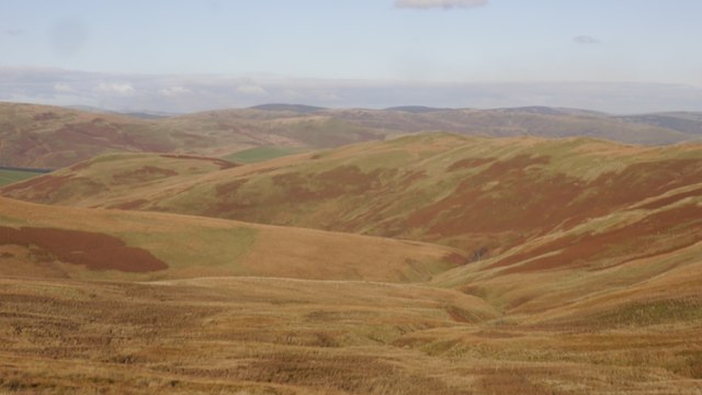
The downs of Birkie Brae are characterized by their rolling hills and expansive meadows, providing a scenic backdrop for outdoor enthusiasts. These grassy slopes are ideal for hiking and walking, allowing visitors to explore the area's natural beauty while enjoying panoramic views of the surrounding countryside.

In addition to the downs, Birkie Brae is also home to vast moorlands. These expansive areas of open land are covered in heather, creating a vibrant purple hue during the summer months. Moorland habitats are rich in biodiversity and provide a haven for various bird species, including red grouse and curlews.

Visitors to Birkie Brae can immerse themselves in the tranquility of the Scottish countryside, as the area is relatively secluded and free from the hustle and bustle of city life. The peaceful atmosphere is further enhanced by the absence of major roads, making it an ideal destination for those seeking relaxation and a connection with nature.

Overall, Birkie Brae in Selkirkshire offers a unique and enchanting experience for nature lovers, with its downs and moorland providing a stunning backdrop for outdoor activities and a peaceful retreat from the modern world.

If you have any feedback on the listing, please let us know in the comments section below.

Birkie Brae Images

Images are sourced within 2km of 55.487605/-3.1259738 or Grid Reference NT2822. Thanks to Geograph Open Source API. All images are credited.

Ridge between Turner Cleuch Law and Black Knowe Head Joining two summits of nearly identical height, Turner Cleuch Law has been surveyed as a few centimetres higher.  Unfortunately there is an electric fence with no crossing places along the ridge. I am on the "wrong" side.
Ridge between Turner Cleuch Law and Black Knowe Head
Joining two summits of nearly identical height, Turner Cleuch Law has been surveyed as a few centimetres higher. Unfortunately there is an electric fence with no crossing places along the ridge. I am on the "wrong" side.
Tussocky moorland, Eldin Hope The head of Eldinhope gave the usual hard going you get when the gradient is low. Trick is to pick up an animal or quad bike track. View towards Dun Rig, south of Peebles.

I had just escaped the electric fence trap on the ridge by a very hazardous and delicate process. Make sure you get the right side of the ridge when you leave Turner Cleuch Law or Black Knowe Head.
Tussocky moorland, Eldin Hope
The head of Eldinhope gave the usual hard going you get when the gradient is low. Trick is to pick up an animal or quad bike track. View towards Dun Rig, south of Peebles. I had just escaped the electric fence trap on the ridge by a very hazardous and delicate process. Make sure you get the right side of the ridge when you leave Turner Cleuch Law or Black Knowe Head.
Eldin Hope Moorland grazed by sheep and cattle.
Eldin Hope
Moorland grazed by sheep and cattle.
North ridge, Black Knowe The ridge to the east of Eldin Hope.
North ridge, Black Knowe
The ridge to the east of Eldin Hope.
Summit area, Meg's Hill Lots of short cropped grass on this hill which makes a rewarding quick ascent from the B709.
Summit area, Meg's Hill
Lots of short cropped grass on this hill which makes a rewarding quick ascent from the B709.
Sheep, Eldinhope Looking across Eldin Hope from near the summit of Meg's Hill.
Sheep, Eldinhope
Looking across Eldin Hope from near the summit of Meg's Hill.
Black Knowe Head The slopes above Eldin Hope. Grazed by sheep and cattle.
Black Knowe Head
The slopes above Eldin Hope. Grazed by sheep and cattle.
Cattle gridded road (B709) near to Windy House Looking north-eastward.
Cattle gridded road (B709) near to Windy House
Looking north-eastward.
Road (B709) at Hartleap Looking north-eastward.
Road (B709) at Hartleap
Looking north-eastward.
Road (B709) on the flank of Birkie Brae Looking south-westward.
Road (B709) on the flank of Birkie Brae
Looking south-westward.
Road (B709) on the flank of Meg's Hill Looking north-eastward.
Road (B709) on the flank of Meg's Hill
Looking north-eastward.
Wall enclosed road (B709) near to Eldinhope Looking south-westward.
Wall enclosed road (B709) near to Eldinhope
Looking south-westward.
Ordnance Survey Cut Mark This mark can be found on a road (B709) bridge near to Windy House.
The recorded details give a height of 337.1728 metres above sea level.
For more detail see : <span class="nowrap"><a title="https://www.bench-marks.org.uk/bm164678" rel="nofollow ugc noopener" href="https://www.bench-marks.org.uk/bm164678">Link</a><img style="margin-left:2px;" alt="External link" title="External link - shift click to open in new window" src="https://s1.geograph.org.uk/img/external.png" width="10" height="10"/></span>
Ordnance Survey Cut Mark
This mark can be found on a road (B709) bridge near to Windy House. The recorded details give a height of 337.1728 metres above sea level. For more detail see : LinkExternal link
Thorny Cleuch and Altrieve Rig Rough grazing immediately east of the forestry plantations above St Mary's Loch
Thorny Cleuch and Altrieve Rig
Rough grazing immediately east of the forestry plantations above St Mary's Loch
Ruined stell and big view, Thorny Cleuch
Altrieve Rig and Peat Law
Altrieve Rig A sheepwalk above the Yarrow Water.
Altrieve Rig
A sheepwalk above the Yarrow Water.
Tussocky ground, Altrieve Rig Much of the moorland here is easy underfoot but there are rougher bits, especially on flatter ground.
Tussocky ground, Altrieve Rig
Much of the moorland here is easy underfoot but there are rougher bits, especially on flatter ground.
Show me another place!

Birkie Brae is located at Grid Ref: NT2822 (Lat: 55.487605, Lng: -3.1259738)

Unitary Authority: The Scottish Borders

Police Authority: The Lothians and Scottish Borders

What 3 Words

///tones.depending.forgotten. Near Ettrick, Scottish Borders

Nearby Locations

Birkie Brae

Related Wikis

Dryhope

Dryhope is a village in the Scottish Borders area of Scotland, by St. Mary's Loch, on the A708. Known for its rolling green hills and ample walking paths...
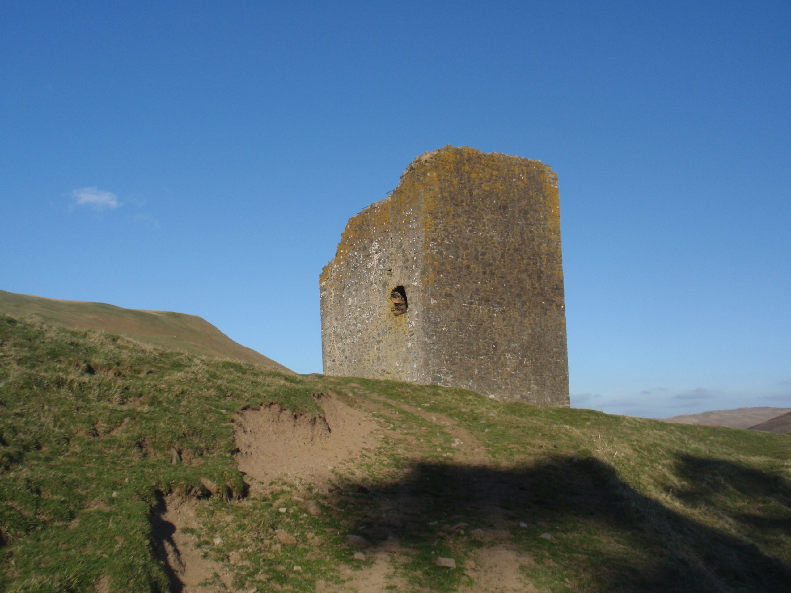
Dryhope Tower

Dryhope Tower is a ruined Scottish peel tower in the valley of the Yarrow Water, in the historic county of Selkirkshire, now part of the Scottish Borders...

Bowerhope

Bowerhope is a village off the A708, in the Scottish Borders area of Scotland, on the banks of St Mary's Loch in Ettrick Forest. == See also == List of...
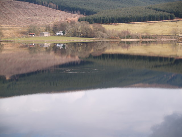
St Mary's Loch

St Mary's Loch is the largest natural loch in the Scottish Borders, and is situated on the south side of the A708 road between Selkirk and Moffat, about...

Nearby Amenities

Located within 500m of 55.487605,-3.1259738
Material: wood
Power: pole
Lat/Long: 55.4881674/-3.1294647
Material: wood
Power: pole
Lat/Long: 55.490124/-3.1280246
Long Grain Rig
Corbett: no
Graham: no
Munro: no
Natural: peak
Lat/Long: 55.484582/-3.1217042
Material: wood
Power: pole
Lat/Long: 55.4919677/-3.1266846
Material: wood
Power: pole
Lat/Long: 55.4913462/-3.1271312
Material: wood
Power: pole
Lat/Long: 55.4907414/-3.1275845
Material: wood
Power: pole
Lat/Long: 55.4894619/-3.1285152
Material: wood
Power: pole
Lat/Long: 55.488816/-3.128994
Material: wood
Power: pole
Lat/Long: 55.4874916/-3.1299663
Material: wood
Power: pole
Lat/Long: 55.4868268/-3.1304558
Material: wood
Power: pole
Lat/Long: 55.4861626/-3.1309614
Material: wood
Power: pole
Lat/Long: 55.4854871/-3.1314522
Material: wood
Power: pole
Lat/Long: 55.4848146/-3.1319417
The data included in this document is from www.openstreetmap.org. The data is made available under ODbL.

Have you been to Birkie Brae?

Leave your review of Birkie Brae below (or comments, questions and feedback).