North Wirral Coastal Park

Downs, Moorland in Cheshire

England

North Wirral Coastal Park

Wirral coastline at Mockbeggar Wharf
Wirral coastline at Mockbeggar Wharf Credit: Colin Park

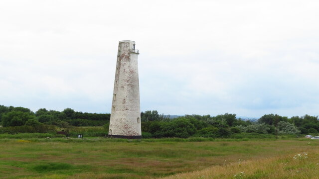
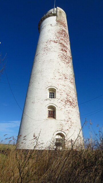
North Wirral Coastal Park is a stunning natural reserve located in Cheshire, England. Spanning across a vast area of downs and moorland, this park offers visitors a unique and diverse landscape to explore. Covering approximately 630 hectares, the park stretches along the picturesque coastline of the River Mersey, providing breathtaking views of the estuary and the Irish Sea.

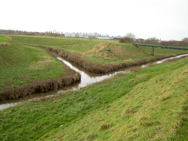
The park boasts a rich variety of habitats, ranging from sand dunes and salt marshes to grasslands and woodland areas. These diverse ecosystems support a wide array of flora and fauna, making it a haven for nature enthusiasts and wildlife lovers. Visitors can spot an impressive range of bird species, including wading birds and migratory species, as well as small mammals and insects.

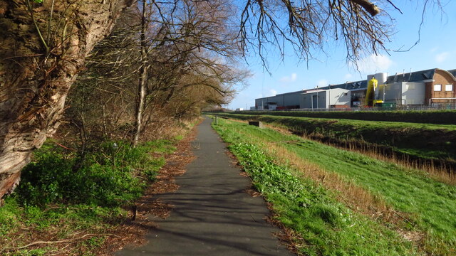
In addition to its natural beauty, North Wirral Coastal Park also offers a range of recreational activities for visitors to enjoy. The park features several walking and cycling trails, allowing visitors to explore the stunning surroundings and take in the fresh sea air. For those interested in water sports, the park provides opportunities for sailing, windsurfing, and kayaking.

Furthermore, the park includes various picnic areas and a designated barbecue spot, making it an ideal place for family outings and gatherings. There are also well-maintained play areas for children, ensuring that everyone can enjoy their visit to the park.

Overall, North Wirral Coastal Park is a remarkable destination for those seeking to immerse themselves in nature and experience the beauty of Cheshire's coastal landscape. With its diverse habitats, abundant wildlife, and recreational facilities, the park offers something for everyone to enjoy.

If you have any feedback on the listing, please let us know in the comments section below.

North Wirral Coastal Park Images

Images are sourced within 2km of 53.417462/-3.115395 or Grid Reference SJ2591. Thanks to Geograph Open Source API. All images are credited.

Wirral coastline at Mockbeggar Wharf
Leasowe Lighthouse, Wirral
Leasowe Road
Leasowe Road
Leasowe Lighthouse
Leasowe Lighthouse
Walkway beside The Birket, Ditton Lane Nature Area
The Coach and Horses, Moreton
Breakwater on the Wallasey Embankment An anchor-shaped breakwater on the Wallasey Embankment between Meols and Leasowe seen from the North Wirral Coastal Park.
Breakwater on the Wallasey Embankment
An anchor-shaped breakwater on the Wallasey Embankment between Meols and Leasowe seen from the North Wirral Coastal Park.
Path through the North Wirral Coastal Park Heading east through the North Wirral Coastal Park towards Leasowe. Leasowe lighthouse can be seen ahead.
Path through the North Wirral Coastal Park
Heading east through the North Wirral Coastal Park towards Leasowe. Leasowe lighthouse can be seen ahead.
Enervators on the Wallasey Embankment at Leasowe These curved concrete upstands, or ‘Enervators’ were added to part of the sloping surface of the embankment in the 1980s to try to break up storm waves.

Source: engineering-timelines.com
Enervators on the Wallasey Embankment at Leasowe
These curved concrete upstands, or ‘Enervators’ were added to part of the sloping surface of the embankment in the 1980s to try to break up storm waves. Source: engineering-timelines.com
Slipway and Embankment at Leasowe The slipway and Wallasey Embankment at Leasowe on the Wirral.
Slipway and Embankment at Leasowe
The slipway and Wallasey Embankment at Leasowe on the Wirral.
The Wallasey Embankment at Leasowe The Wallasey Embankment was built to protect part of the low-lying north coast of the Wirral from sea erosion and flooding. The concrete surface seen today dates from work completed in 1981 but work to protect the coast here began in 1794.

Source: engineering-timelines.com
The Wallasey Embankment at Leasowe
The Wallasey Embankment was built to protect part of the low-lying north coast of the Wirral from sea erosion and flooding. The concrete surface seen today dates from work completed in 1981 but work to protect the coast here began in 1794. Source: engineering-timelines.com
Leasowe Lighthouse Leasowe Lighthouse was built in 1763 by Liverpool Corporation's Docks Committee and is the oldest brick-built lighthouse in Britain. Since 1989 it has been the base for the ranger service of the North Wirral Coastal Park and now houses a visitor centre which is occasionally open to the public.

Wikipedia <span class="nowrap"><a title="https://en.wikipedia.org/wiki/Leasowe" rel="nofollow ugc noopener" href="https://en.wikipedia.org/wiki/Leasowe">Link</a><img style="margin-left:2px;" alt="External link" title="External link - shift click to open in new window" src="https://s1.geograph.org.uk/img/external.png" width="10" height="10"/></span>
Leasowe Lighthouse
Leasowe Lighthouse was built in 1763 by Liverpool Corporation's Docks Committee and is the oldest brick-built lighthouse in Britain. Since 1989 it has been the base for the ranger service of the North Wirral Coastal Park and now houses a visitor centre which is occasionally open to the public. Wikipedia LinkExternal link
Car Park at Leasowe Common Car Park at Leasowe Common next to the North Wirral Coastal Park.
Car Park at Leasowe Common
Car Park at Leasowe Common next to the North Wirral Coastal Park.
Car Park at Leasowe Common Car Park at Leasowe Common next to the North Wirral Coastal Park and Wallasey Embankment.
Car Park at Leasowe Common
Car Park at Leasowe Common next to the North Wirral Coastal Park and Wallasey Embankment.
The Wallasey Embankment at Leasowe The Wallasey Embankment was built to protect part of the low-lying north coast of the Wirral from sea erosion and flooding. The concrete surface seen today dates from work completed in 1981 but work to protect the coast here began in 1794.

Source: engineering-timelines.com
The Wallasey Embankment at Leasowe
The Wallasey Embankment was built to protect part of the low-lying north coast of the Wirral from sea erosion and flooding. The concrete surface seen today dates from work completed in 1981 but work to protect the coast here began in 1794. Source: engineering-timelines.com
Show me another place!

North Wirral Coastal Park is located at Grid Ref: SJ2591 (Lat: 53.417462, Lng: -3.115395)

Unitary Authority: Wirral

Police Authority: Merseyside

What 3 Words

///moons.shakes.retire. Near Moreton, Merseyside

Related Wikis

North Wirral Coastal Park

The North Wirral Coastal Park, on the Wirral Peninsula, England is a coastal park including public open space, common land, natural foreshore and sand...

The Birket

The Birket is a tributary of the River Mersey, on the Wirral, Merseyside. The watercourse starts as lowland field drainage south of Hoylake and flows along...

New Brighton F.C. (rugby union)

New Brighton Football Club (Rugby Union) are a rugby union team based in Moreton, Merseyside, UK. They currently play in the ADM Lancashire Championship...

Moreton railway station (Merseyside)

Moreton railway station serves the town of Moreton, in Merseyside, England. The station is on the West Kirby branch of the Wirral Line, which is part of...

Nearby Amenities

Located within 500m of 53.417462,-3.115395
Source: PGS
Lat/Long: 53.4193825/-3.1099159
Source: PGS
Lat/Long: 53.4183495/-3.1129213
Source: PGS
Lat/Long: 53.4175325/-3.1154787
Source: PGS
Lat/Long: 53.4167125/-3.1183251
Source: PGS
Lat/Long: 53.4157568/-3.1215744
Bus Stop
PASTURE RD/LEASOWE RD/MORETON SHORE
Bus: yes
Naptan AtcoCode: 2800S25051A
Naptan Bearing: N
Naptan CommonName: PASTURE RD/LEASOWE RD/MORETON SHORE
Naptan Indicator: PASTURE ROAD/LEASOWE ROAD/MORETON SHORE
Naptan Landmark: Pastre Rd/M'rtn Shre
Naptan NaptanCode: meraptdp
Naptan Notes: No Notes
Naptan ShortCommonName: Moreton Shore
Naptan Street: PASTURE ROAD
Naptan Verified: no
Public Transport: platform
Source: naptan_import
Lat/Long: 53.4135235/-3.1178601
Bus Stop
PASTURE RD/LEASOWE ROAD/MORETON SHORE
Bus: yes
Naptan AtcoCode: 2800S25051B
Naptan Bearing: S
Naptan CommonName: PASTURE RD/LEASOWE ROAD/MORETON SHORE
Naptan Indicator: PASTURE ROAD/LEASOWE ROAD/MORETON SHORE
Naptan Landmark: OPP 203
Naptan NaptanCode: meraptdt
Naptan Notes: No Notes
Naptan ShortCommonName: Moreton Shore
Naptan Street: PASTURE ROAD
Naptan Verified: no
Public Transport: platform
Source: naptan_import
Lat/Long: 53.4140269/-3.1178583
Bus Stop
LEASOWE ROAD/PASTURE ROAD
Bus: yes
Naptan AtcoCode: 2800S25052A
Naptan Bearing: E
Naptan CommonName: LEASOWE ROAD/PASTURE ROAD
Naptan Indicator: LEASOWE ROAD/PASTURE ROAD
Naptan Landmark: OPP WIRRAL CHRISTIAN CENTRE (OLD LEASOWE CHILDRE
Naptan NaptanCode: meraptdw
Naptan Notes: No Notes
Naptan ShortCommonName: Wirral Christian Cn
Naptan Street: LEASOWE ROAD
Naptan Verified: no
Public Transport: platform
Source: naptan_import
Lat/Long: 53.4158287/-3.1126242
Bus Stop
LEASOWE ROAD/PASTURE ROAD
Bus: yes
Naptan AtcoCode: 2800S25052B
Naptan Bearing: W
Naptan CommonName: LEASOWE ROAD/PASTURE ROAD
Naptan Indicator: LEASOWE ROAD/PASTURE ROAD
Naptan Landmark: O/S WIRRAL CHRISTIAN CENTRE-OLD LEASOWE CHILDREN
Naptan NaptanCode: meraptga
Naptan Notes: No Notes
Naptan ShortCommonName: Wirral Christian Cn
Naptan Street: LEASOWE ROAD
Naptan Verified: no
Public Transport: platform
Source: naptan_import
Lat/Long: 53.4159166/-3.1109111
Bus Stop
LEASOWE ROAD/MEREHEATH
Bus: yes
Naptan AtcoCode: 2800S25121A
Naptan Bearing: W
Naptan CommonName: LEASOWE ROAD/MEREHEATH
Naptan Indicator: LEASOWE ROAD/MEREHEATH
Naptan Landmark: LEASOWE ROAD/MEREHEATH
Naptan NaptanCode: mergmawg
Naptan Notes: No Notes
Naptan ShortCommonName: Leasowe Rd
Naptan Street: LEASOWE ROAD
Naptan Verified: no
Public Transport: platform
Source: naptan_import
Lat/Long: 53.415279/-3.1147013
Barrier: yes
Bicycle: yes
Foot: yes
Motorcar: yes
Motorcycle: yes
Note: Bollards placed at entrance to car park to prevent access by wide vehicles (lorries etc, may also stop caravans and motor homes)
Lat/Long: 53.4149935/-3.1182974
Wallasey Embankment Leasowe Common
Beach Safety Sign
Emergency: beach_safety_sign
Note: RNLI beach safety sign. The reference is a RNLI Unique Beach Location Code (UBLC).
Operator: RNLI
Ref: WL84
Lat/Long: 53.4161107/-3.119075
Lifeguard Tower
Emergency: lifeguard_tower
Operator: RNLI
Lat/Long: 53.416229/-3.1188651
Generator Method: photovoltaic
Generator Output Electricity: yes
Generator Source: solar
Generator Type: solar_photovoltaic_panel
Location: roof
Power: generator
Lat/Long: 53.4148871/-3.1114988
Generator Method: photovoltaic
Generator Output Electricity: yes
Generator Source: solar
Generator Type: solar_photovoltaic_panel
Location: roof
Power: generator
Lat/Long: 53.414836/-3.1119923
Generator Method: photovoltaic
Generator Output Electricity: yes
Generator Source: solar
Generator Type: solar_photovoltaic_panel
Location: roof
Power: generator
Lat/Long: 53.4134042/-3.1124961
Post Box
Collection Times: Mo-Fr 17:30; Sa 12:00
Description: QEII Type K post box CH46 147 by Carron Company at Mereheath, Moreton
Manufacturer: Carron Company
Operator: Royal Mail
Operator Wikidata: Q638098
Post Box Design: type_k
Post Box Type: pillar
Ref: CH46 147
Royal Cypher: EIIR
Royal Cypher Wikidata: Q33102113
Wikimedia Commons: File:Post box at Mereheath, Moreton.jpg
Lat/Long: 53.4151752/-3.1142539
Golf: pin
Lat/Long: 53.4176679/-3.1127904
Golf: pin
Lat/Long: 53.4180671/-3.1108498
Waste Basket
Lat/Long: 53.4160118/-3.1184569
North Wirral Coastal Park
Tourism: information
Lat/Long: 53.4157113/-3.1187561
Waste Basket
Lat/Long: 53.4161724/-3.1191007
Defibrillator
Access: yes
Defibrillator Location: public toilets
Emergency: defibrillator
Indoor: no
Lat/Long: 53.4148335/-3.1177928
Give Way
Direction: forward
Lat/Long: 53.4147173/-3.1181761
Give Way
Direction: backward
Lat/Long: 53.4146558/-3.1182406
The data included in this document is from www.openstreetmap.org. The data is made available under ODbL.

Have you been to North Wirral Coastal Park?

Leave your review of North Wirral Coastal Park below (or comments, questions and feedback).