Gosforth Crag Moss

Downs, Moorland in Cumberland Copeland

England

Gosforth Crag Moss

Bridleway in Mosedale This bridleway in Mosedale leads up to the Black Sail Pass.
Bridleway in Mosedale Credit: Philip Halling

Gosforth Crag Moss is a vast expanse of moorland located in Cumberland, England. Situated in the northwestern part of the country, it is a notable natural feature in the region. The moss covers an extensive area, with its boundaries stretching across the Cumbrian landscape.

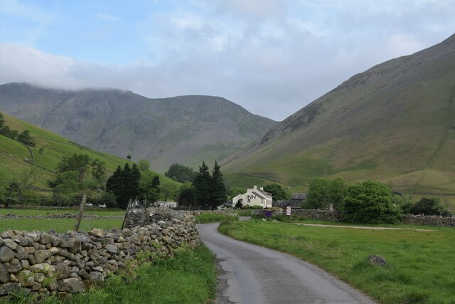
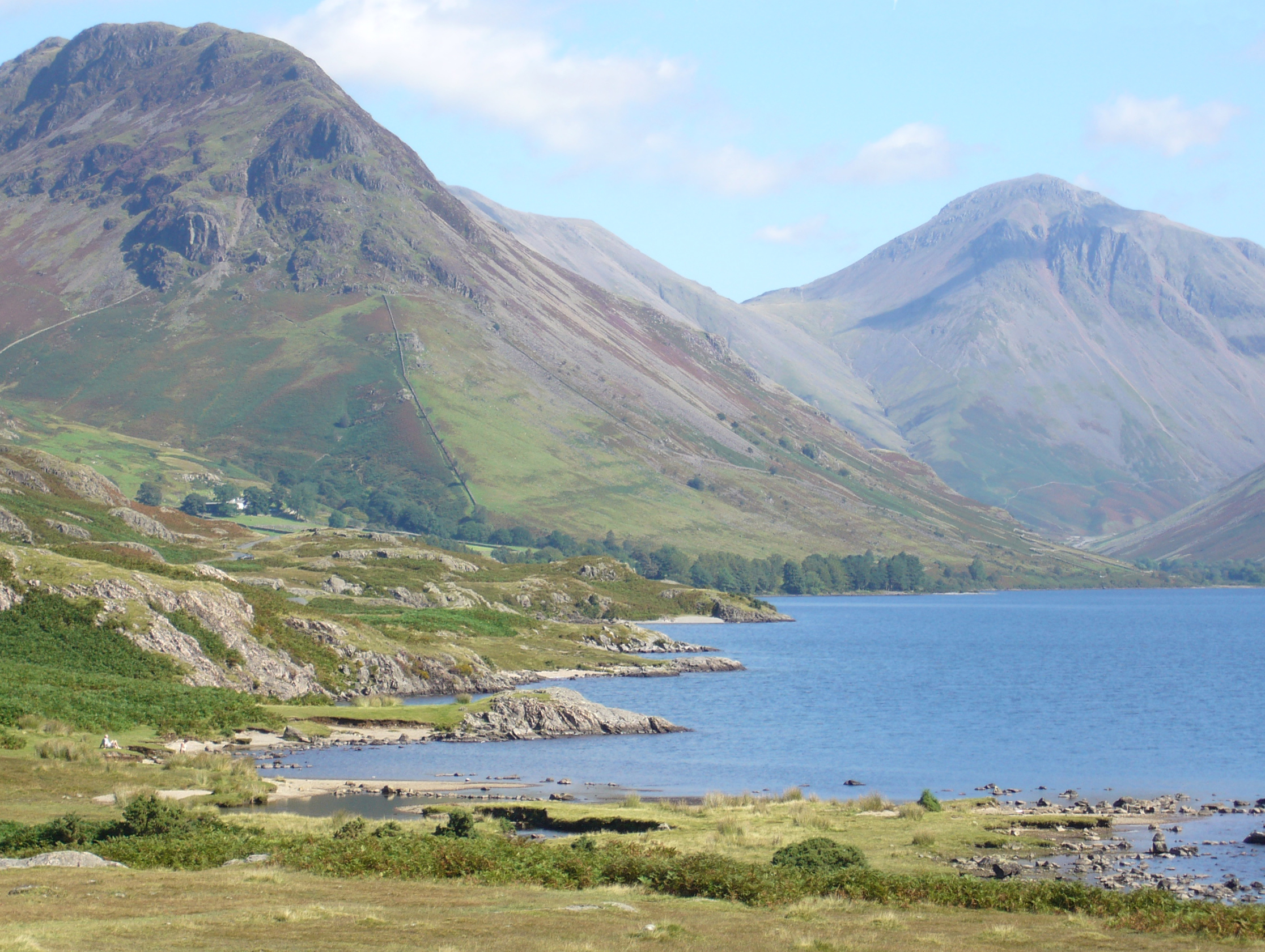
The landscape of Gosforth Crag Moss is characterized by rolling hills, heather-covered moorland, and scattered outcrops of craggy rocks. The moss itself is a rich habitat for various plant and animal species, making it an important ecological site. The area is home to a diverse range of plant life, including sphagnum mosses, cotton grass, and heather, which thrive in the moisture-retaining peat soil.

The moss is an ideal spot for birdwatching enthusiasts, as it provides a sanctuary for numerous avian species. Visitors can often spot birds such as curlews, lapwings, red grouse, and skylarks, among others. The open moorland also offers stunning panoramic views of the surrounding countryside, making it a popular destination for hikers and nature lovers.

Gosforth Crag Moss is steeped in history, with evidence of human activity dating back centuries. The moss has archaeological significance, with remnants of ancient settlements and burial mounds scattered throughout the area. These historical remains provide a glimpse into the lives of the people who once inhabited this land.

In summary, Gosforth Crag Moss is a picturesque and ecologically important moorland in Cumberland. With its diverse plant and animal life, stunning landscapes, and historical significance, it is a captivating destination for those seeking to explore the natural beauty and rich heritage of the region.

If you have any feedback on the listing, please let us know in the comments section below.

Gosforth Crag Moss Images

Images are sourced within 2km of 54.469819/-3.2843482 or Grid Reference NY1609. Thanks to Geograph Open Source API. All images are credited.

Bridleway in Mosedale This bridleway in Mosedale leads up to the Black Sail Pass.
Bridleway in Mosedale
This bridleway in Mosedale leads up to the Black Sail Pass.
Path heading up the Mosedale valley Path from Wasdale Head heading up the Mosedale valley
Path heading up the Mosedale valley
Path from Wasdale Head heading up the Mosedale valley
Wasdale Head These former farm buildings are now used to serve tourists with a shop and holiday apartments.
The steep fell in the background is the northern shoulder of Yewbarrow.
There is an Ordnance Survey cut benchmark on the pillar between the doors beyond the yellow defibrillator box (photograph <a href="https://www.geograph.org.uk/photo/7123697">NY1808 : Benchmark, Wasdale Head</a>).
Wasdale Head
These former farm buildings are now used to serve tourists with a shop and holiday apartments. The steep fell in the background is the northern shoulder of Yewbarrow. There is an Ordnance Survey cut benchmark on the pillar between the doors beyond the yellow defibrillator box (photograph NY1808 : Benchmark, Wasdale Head).
Benchmark, Wasdale Head Detail of the Ordnance Survey cut benchmark on a former barn (now a shop and holiday accommodation) at Wasdale Head. In spite of the many years since the benchmark was cut, the darkness of the cut stone still contrasts with the weathered surface of the natural block used in the construction of the barn.
The benchmark marks a height of 80.3483m above sea level (Ordnance Datum Newlyn) last verified in 1956 (location photograph <a href="https://www.geograph.org.uk/photo/7123690">NY1808 : Wasdale Head</a>).
Benchmark, Wasdale Head
Detail of the Ordnance Survey cut benchmark on a former barn (now a shop and holiday accommodation) at Wasdale Head. In spite of the many years since the benchmark was cut, the darkness of the cut stone still contrasts with the weathered surface of the natural block used in the construction of the barn. The benchmark marks a height of 80.3483m above sea level (Ordnance Datum Newlyn) last verified in 1956 (location photograph NY1808 : Wasdale Head).
Moody day at Wasdale Head The morning’s low cloud and rain had cleared and as a foretaste of better weather to come a brief glimpse of sun catches Great Gable between Great Napes and Tom Blue.
Moody day at Wasdale Head
The morning’s low cloud and rain had cleared and as a foretaste of better weather to come a brief glimpse of sun catches Great Gable between Great Napes and Tom Blue.
Wastwater and Wasdale Head Some of the most remote Lakeland country - taken from the path that follows Wastwater through some really brutal scree slopes.
Wastwater and Wasdale Head
Some of the most remote Lakeland country - taken from the path that follows Wastwater through some really brutal scree slopes.
Queen Victoria (VR) Post Box (1837-1901), Wasdale Head
Packhorse Bridge Over Mosdale Beck, Wasdale Head
Ritson Force Waterfall (Upper Section), Wasdale Head The waterfall is said to be named after Will Ritson, landlord and tall tale teller at the nearby Wasdale Head Inn.
Ritson Force Waterfall (Upper Section), Wasdale Head
The waterfall is said to be named after Will Ritson, landlord and tall tale teller at the nearby Wasdale Head Inn.
Ritson Force Waterfall (Lower Section), Wasdale Head The waterfall is said to be named after Will Ritson, landlord and tall tale teller at the nearby Wasdale Head Inn.
Ritson Force Waterfall (Lower Section), Wasdale Head
The waterfall is said to be named after Will Ritson, landlord and tall tale teller at the nearby Wasdale Head Inn.
Valley of Mosedale Beck Mosedale is one of the two main side valleys branching from Wasdale at Wasdale Head; Mosedale apparently means dreary valley!
The mountain at the centre of the image is Pillar.
Valley of Mosedale Beck
Mosedale is one of the two main side valleys branching from Wasdale at Wasdale Head; Mosedale apparently means dreary valley! The mountain at the centre of the image is Pillar.
The Wasdale Head Inn
Wasdale Head Inn The popular inn appears unchanged since my last visit almost exactly eight years ago <a href="https://www.geograph.org.uk/photo/4698804">NY1808 : The Wasdale Head Inn</a>.
Wasdale Head Inn
The popular inn appears unchanged since my last visit almost exactly eight years ago NY1808 : The Wasdale Head Inn.
Mosedale Beck Mosedale Beck with the packhorse bridge to the right.  The mountain in the background is Pillar.
Mosedale Beck
Mosedale Beck with the packhorse bridge to the right. The mountain in the background is Pillar.
Mosedale Beck Mosedale Beck in Mosedale, pictured here just above Wasdale Head.
Mosedale Beck
Mosedale Beck in Mosedale, pictured here just above Wasdale Head.
Bridleway in Mosedale Bridleway leading into Mosedale and eventually over the Black Sail Pass.
Bridleway in Mosedale
Bridleway leading into Mosedale and eventually over the Black Sail Pass.
Mosedale Beck Mosedale Beck meandering through Mosedale, viewed from the bridleway leading to Black Sail Pass.
Mosedale Beck
Mosedale Beck meandering through Mosedale, viewed from the bridleway leading to Black Sail Pass.
Bridleway gate Gate and stile on a bridleway in Mosedale.  Pillar is the mountain at the head of the valley.
Bridleway gate
Gate and stile on a bridleway in Mosedale. Pillar is the mountain at the head of the valley.
Show me another place!

Gosforth Crag Moss is located at Grid Ref: NY1609 (Lat: 54.469819, Lng: -3.2843482)

Administrative County: Cumbria

District: Copeland

Police Authority: Cumbria

What 3 Words

///outboard.sooner.slip. Near Seascale, Cumbria

Related Wikis

Yewbarrow

Yewbarrow is a fell, in the English Lake District, which lies immediately north of the head of Wast Water. It is 628 metres (2,060 feet) high and in shape...

Red Pike (Wasdale)

Red Pike is a fell in the English Lake District. It is 826 m or 2,709 ft high and lies due north of Wast Water. It is often climbed as part of the Mosedale...

Mosedale Beck (Wast Water)

Mosedale Beck is a stream in Cumbria which runs into Wast Water, which is the deepest lake in England. Mosedale Beck rises in Little Scoat Fell, it then...

St Olaf's Church, Wasdale

St Olaf's Church in Wasdale Head, Cumbria, is England's smallest parish church. The earliest record of a church on this site is from 1550, though it is...

Nearby Amenities

Located within 500m of 54.469819,-3.2843482
Gosforth Crag Moss
Place: locality
Lat/Long: 54.4689348/-3.2837881
Ford: yes
Lat/Long: 54.4677501/-3.2862698
Ford: yes
Lat/Long: 54.4691607/-3.2837239
Waterway: waterfall
Lat/Long: 54.4670732/-3.2855561
Ford: yes
Lat/Long: 54.471931/-3.2787732
Ford: yes
Lat/Long: 54.4674024/-3.2858297
Ford: yes
Lat/Long: 54.4696514/-3.2843826
Ford: yes
Lat/Long: 54.4707138/-3.283542
Ford: yes
Lat/Long: 54.4672647/-3.2859821
Ford: yes
Lat/Long: 54.466346/-3.2868324
The data included in this document is from www.openstreetmap.org. The data is made available under ODbL.

Have you been to Gosforth Crag Moss?

Leave your review of Gosforth Crag Moss below (or comments, questions and feedback).