Buckbarrow Moss

Downs, Moorland in Cumberland Copeland

England

Buckbarrow Moss

Flush Bracket benchmark, Seatallan Detail of the flush bracket benchmark on the triangulation pillar on the summit of Seatallan. The flush bracket, benchmark number S5762, is on the south south east face of the pillar and marks a height of 692.200m above sea level (Ordnance Datum Newlyn), last levelled in 1952 (location photograph <a href="https://www.geograph.org.uk/photo/7080016">NY1308 : Triangulation pillar, Seatallan</a>).
Flush Bracket benchmark, Seatallan Credit: Adrian Taylor

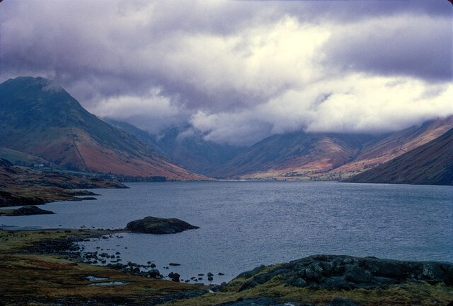
Buckbarrow Moss, located in Cumberland, England, is a captivating area of downs and moorland encompassing a vast expanse of natural beauty. Stretching across several miles, this scenic landscape offers a diverse range of flora and fauna, making it a haven for nature enthusiasts and hikers alike.

The moss is characterized by its rolling hills, heather-covered moors, and open grasslands, providing a stunning backdrop for visitors to immerse themselves in the tranquility of the countryside. The area is also home to an array of wildlife, including birds, mammals, and reptiles, offering ample opportunities for birdwatching and animal spotting.

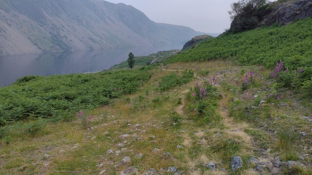
Buckbarrow Moss is particularly renowned for its unique geological features. The moss is dotted with numerous peat bogs and pools, which have formed over centuries due to the accumulation of plant material and rainwater. These wetlands provide a diverse habitat for a variety of plant species, including sphagnum mosses, cotton grass, and heather, which thrive in the acidic conditions.

The moss is crisscrossed by a network of well-maintained footpaths and trails, allowing visitors to explore the area at their own pace. The routes offer breathtaking views of the surrounding countryside, with the distant peaks of the Lake District visible on clear days.

Whether it's a leisurely stroll, a challenging hike, or simply a chance to connect with nature, Buckbarrow Moss in Cumberland guarantees a memorable experience. With its natural splendor and rich biodiversity, it is a place where visitors can escape the hustle and bustle of everyday life and find solace in the serenity of the countryside.

If you have any feedback on the listing, please let us know in the comments section below.

Buckbarrow Moss Images

Images are sourced within 2km of 54.450881/-3.3252139 or Grid Reference NY1406. Thanks to Geograph Open Source API. All images are credited.

Flush Bracket benchmark, Seatallan Detail of the flush bracket benchmark on the triangulation pillar on the summit of Seatallan. The flush bracket, benchmark number S5762, is on the south south east face of the pillar and marks a height of 692.200m above sea level (Ordnance Datum Newlyn), last levelled in 1952 (location photograph <a href="https://www.geograph.org.uk/photo/7080016">NY1308 : Triangulation pillar, Seatallan</a>).
Flush Bracket benchmark, Seatallan
Detail of the flush bracket benchmark on the triangulation pillar on the summit of Seatallan. The flush bracket, benchmark number S5762, is on the south south east face of the pillar and marks a height of 692.200m above sea level (Ordnance Datum Newlyn), last levelled in 1952 (location photograph NY1308 : Triangulation pillar, Seatallan).
Triangulation pillar, Seatallan The triangulation pillar on the summit of Seatallan.
The flush bracket benchmark number S5762 on the south south east face of the pillar marks a height of 692.200m above sea level (Ordnance Datum Newlyn) last levelled in 1952 (photograph <a href="https://www.geograph.org.uk/photo/7079993">NY1308 : Flush Bracket benchmark, Seatallan</a>).
Triangulation pillar, Seatallan
The triangulation pillar on the summit of Seatallan. The flush bracket benchmark number S5762 on the south south east face of the pillar marks a height of 692.200m above sea level (Ordnance Datum Newlyn) last levelled in 1952 (photograph NY1308 : Flush Bracket benchmark, Seatallan).
Wast Water with brooding cloud Perhaps not the day to climb the hills.
Wast Water with brooding cloud
Perhaps not the day to climb the hills.
Beside Wast Water With overnight camping not permitted, this group seemed to go to a great deal of trouble to make a coffee and a bacon sandwich.
Beside Wast Water
With overnight camping not permitted, this group seemed to go to a great deal of trouble to make a coffee and a bacon sandwich.
Beside Wast Water With overnight camping not permitted, this group seemed to go to a great deal of trouble to make a coffee and a bacon sandwich.
Beside Wast Water
With overnight camping not permitted, this group seemed to go to a great deal of trouble to make a coffee and a bacon sandwich.
Beside Wast Water With overnight camping not permitted, this group seemed to go to a great deal of trouble to make a coffee and a bacon sandwich.
Beside Wast Water
With overnight camping not permitted, this group seemed to go to a great deal of trouble to make a coffee and a bacon sandwich.
Wast Water Looking up the lake, with Yewbarrow to the left of picture and Great Gable to the right.
Wast Water
Looking up the lake, with Yewbarrow to the left of picture and Great Gable to the right.
Direction Sign - Signpost beside Wast Water Located on the southwest side of the junctions of the Wasdale Head and Greendale roads, in Wasdale parish. 3 arms and annulus finial. For an older photo before it was refurbished, see  <a title="https://www.geograph.org.uk/photo/6102831," href="https://www.geograph.org.uk/photo/6102831,">Link</a> and also <a title="https://www.geograph.org.uk/photo/3197897" href="https://www.geograph.org.uk/photo/3197897">Link</a> and <a title="https://www.geograph.org.uk/photo/2162941" href="https://www.geograph.org.uk/photo/2162941">Link</a>.

Milestone Society National ID: CU_NY1505
Direction Sign - Signpost beside Wast Water
Located on the southwest side of the junctions of the Wasdale Head and Greendale roads, in Wasdale parish. 3 arms and annulus finial. For an older photo before it was refurbished, see Link and also Link and Link. Milestone Society National ID: CU_NY1505
Greendale Tarn Below Middle Fell looking to Greendale Tarn
Greendale Tarn
Below Middle Fell looking to Greendale Tarn
Bridleway heading down by Nether Beck Bridleway heading down by Nether Beck near Standy Gill
Bridleway heading down by Nether Beck
Bridleway heading down by Nether Beck near Standy Gill
Bridleway from Nether Beck Bridleway from Nether Beck coming out on the road by Wast Water
Bridleway from Nether Beck
Bridleway from Nether Beck coming out on the road by Wast Water
Wall, Greendale Backed with the impressive Buckbarrow which looks like a smaller version of Pike o Stickle
Wall, Greendale
Backed with the impressive Buckbarrow which looks like a smaller version of Pike o Stickle
Violet The fells are studded with violets at this time of year
Violet
The fells are studded with violets at this time of year
Greendale Gill Gorse coming into flower by the gill
Greendale Gill
Gorse coming into flower by the gill
Old Fold By Tongues Gills on the steep west bank of Greendale Gill
Old Fold
By Tongues Gills on the steep west bank of Greendale Gill
On Buckbarrow On Broad Crag, Buckbarrow. Looking towards The Scafells
On Buckbarrow
On Broad Crag, Buckbarrow. Looking towards The Scafells
On Buckbarrow Looking towards Middle Fell
On Buckbarrow
Looking towards Middle Fell
On Seatallen On the extensive southern slope. There are several rudimentary bields in the sprinkling of boulders on the flank.
On Seatallen
On the extensive southern slope. There are several rudimentary bields in the sprinkling of boulders on the flank.
Show me another place!

Buckbarrow Moss is located at Grid Ref: NY1406 (Lat: 54.450881, Lng: -3.3252139)

Administrative County: Cumbria

District: Copeland

Police Authority: Cumbria

What 3 Words

///wired.decimal.they. Near Seascale, Cumbria

Nearby Locations

Buckbarrow Moss

Related Wikis

Middle Fell

Middle Fell is a hill or fell in the English Lake District. It is a satellite of Seatallan standing above the northern shore of Wastwater. Middle Fell...

Buckbarrow

Buckbarrow is a small fell in the English Lake District overlooking the western end of Wastwater. It is featured in Alfred Wainwright’s Pictorial Guide...

Seatallan

Seatallan is a mountain in the western part of the English Lake District. It is rounded, grassy and fairly unassuming, occupying a large amount of land...

Wast Water

Wast Water or Wastwater () is a lake located in Wasdale, a valley in the western part of the Lake District National Park, England. The lake is almost three...

Nearby Amenities

Located within 500m of 54.450881,-3.3252139
Ford: yes
Lat/Long: 54.4519022/-3.3253991
Buckbarrow Moss
Place: locality
Lat/Long: 54.4508137/-3.3264806
Brown How
Place: locality
Lat/Long: 54.4480188/-3.3229031
Waterway: waterfall
Lat/Long: 54.4465343/-3.3248154
Waterway: waterfall
Lat/Long: 54.4467269/-3.3239693
Ford: yes
Lat/Long: 54.4507503/-3.324415
The data included in this document is from www.openstreetmap.org. The data is made available under ODbL.

Have you been to Buckbarrow Moss?

Leave your review of Buckbarrow Moss below (or comments, questions and feedback).