Birkby Fell

Downs, Moorland in Cumberland Copeland

England

Birkby Fell

Water Crag across Linbeck Gill
Water Crag across Linbeck Gill Credit: Stephen Dawson

Birkby Fell is a picturesque area located in the county of Cumberland, England. It is situated in the northwestern part of the county, and is known for its stunning landscapes and natural beauty. The fell covers a large expanse of land, encompassing both downs and moorland.

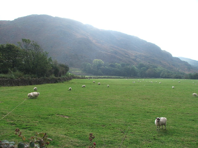
The downs of Birkby Fell are characterized by rolling hills and open grasslands. These areas provide ample grazing opportunities for livestock, and are often dotted with sheep and cattle. The downs offer panoramic views of the surrounding countryside, with the distant hills and valleys creating a breathtaking vista.

The moorland of Birkby Fell is a wilder and more rugged terrain. It is covered in heather and bracken, creating a rich tapestry of colors throughout the seasons. The moorland is home to a diverse range of flora and fauna, including various species of birds, mammals, and plant life. It is a popular destination for nature enthusiasts and birdwatchers, who come to observe the unique wildlife that thrives in this habitat.

Visitors to Birkby Fell can enjoy a range of recreational activities, such as hiking, cycling, and picnicking. There are numerous trails and paths that crisscross the fell, allowing visitors to explore its various landscapes and discover hidden gems along the way.

Overall, Birkby Fell offers a peaceful and idyllic escape from the hustle and bustle of everyday life. Its natural beauty and serene atmosphere make it a perfect destination for those seeking tranquility and a connection with nature.

If you have any feedback on the listing, please let us know in the comments section below.

Birkby Fell Images

Images are sourced within 2km of 54.355831/-3.3263531 or Grid Reference SD1396. Thanks to Geograph Open Source API. All images are credited.

Water Crag across Linbeck Gill
Water Crag. Looking SW from its neighbour Rough Crag.
Water Crag.
Looking SW from its neighbour Rough Crag.
Brantrake Crags looking S from the near the road junction at SD 148 990
Brantrake Crags
looking S from the near the road junction at SD 148 990
Stords Hill. Stords Hill, as seen from the boathouse on Devoke Water.
Stords Hill.
Stords Hill, as seen from the boathouse on Devoke Water.
High Coppice The older High Coppice wood now has a backdrop of more recent plantings.
High Coppice
The older High Coppice wood now has a backdrop of more recent plantings.
Stock's Bridge An unusual design, using galvanised steel, wire and timber. Crosses the River Esk.
Stock's Bridge
An unusual design, using galvanised steel, wire and timber. Crosses the River Esk.
River Esk At Stock's Bridge. Now in the final run-out into the sea, the crystal clear river meanders gently.
River Esk
At Stock's Bridge. Now in the final run-out into the sea, the crystal clear river meanders gently.
From White Pike White Pike throws out a steep buttress of crags North West of its summit cairn which sits in the North East corner of the square. Looking down towards Burkby Fell.
From White Pike
White Pike throws out a steep buttress of crags North West of its summit cairn which sits in the North East corner of the square. Looking down towards Burkby Fell.
Birkby Fell From the slopes of White Pike en route for Devoke Water.
Birkby Fell
From the slopes of White Pike en route for Devoke Water.
Devoke Water The largest Tarn in the Lake District having a surface area of over Three Hundred Thousand square feet in old money.The deepest point is at about Forty Six Feet on the North side of the Tarn. According to Heaton Cooper in the Thirteenth Century it was named 'Dudockis Terne and also Fosse Terne.' The locals call it 'Duvvock Water'
Devoke Water
The largest Tarn in the Lake District having a surface area of over Three Hundred Thousand square feet in old money.The deepest point is at about Forty Six Feet on the North side of the Tarn. According to Heaton Cooper in the Thirteenth Century it was named 'Dudockis Terne and also Fosse Terne.' The locals call it 'Duvvock Water'
Waterfall, Linbeck Gill Linbeck Gill is the outflow from Devoke Water. Water Crag in shot.
Waterfall, Linbeck Gill
Linbeck Gill is the outflow from Devoke Water. Water Crag in shot.
Devoke Water The small island is called Watness Coy
Devoke Water
The small island is called Watness Coy
Stainton Fell From the slopes of Stainton Pike
Stainton Fell
From the slopes of Stainton Pike
Looking North, Woodend Height Devoke Water in the foreground, Kirk Fell central on the horizon.
Looking North, Woodend Height
Devoke Water in the foreground, Kirk Fell central on the horizon.
White Pike from Woodend Height Great ridge walking above Devoke Water.White Pike's tall Cairn just visible on the skyline
White Pike from Woodend Height
Great ridge walking above Devoke Water.White Pike's tall Cairn just visible on the skyline
Cairn on a Rock On the approach to White Pike. The Western Fells fill the skyline
Cairn on a Rock
On the approach to White Pike. The Western Fells fill the skyline
Cairn, White Pike An Outlying Wainwright, one of three in this square along with Yoadcastle and Woodend Height
Cairn, White Pike
An Outlying Wainwright, one of three in this square along with Yoadcastle and Woodend Height
Show me another place!

Birkby Fell is located at Grid Ref: SD1396 (Lat: 54.355831, Lng: -3.3263531)

Administrative County: Cumbria

District: Copeland

Police Authority: Cumbria

What 3 Words

///olive.preoccupied.segregate. Near Seascale, Cumbria

Nearby Locations

Birkby Fell Raven Crag

Related Wikis

Devoke Water

Devoke Water is a small lake in the south west of the Lake District in North West England. It is the largest tarn in the Lake District, a tarn being a...

Stainton Pike

Stainton Pike is a hill in the English Lake District, near Waberthwaite, Cumbria. It is the subject of a chapter of Wainwright's book The Outlying Fells...

Woodend, Ulpha

Woodend is situated between the Duddon Valley and the village of Ulpha and the valley of Eskdale, high up on Birker Fell, approximately 950 feet above...

Muncaster Fell

Muncaster Fell is a fell at the far western edge of the Lake District National Park, in Cumbria, England. Muncaster Fell is a long, narrow ridge of land...

Broad Oak, Cumbria

Broad Oak is a hamlet in Cumbria, England. It is located along the A595 road, 14.4 miles (23.2 km) by road south of Egremont. == See also == List of places...

St Michael's Church, Muncaster

St Michael's Church is in the grounds of Muncaster Castle, near Ravenglass, Cumbria, England. It is an active Anglican parish church in the deanery of...

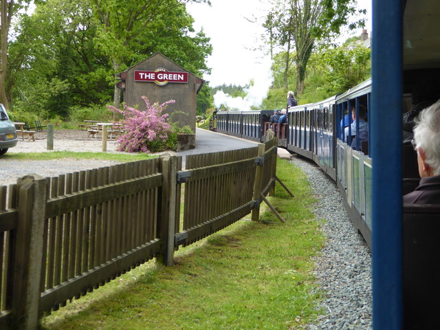
The Green railway station

The Green is a railway station on the 15-inch gauge Ravenglass & Eskdale Railway in the Lake District National Park and the English county of Cumbria....

Muncaster Castle

Muncaster Castle is a privately owned castle overlooking the River Esk, about a mile east of the west-coastal town of Ravenglass in Cumbria, England. It...

Nearby Amenities

Located within 500m of 54.355831,-3.3263531
Ford: yes
Lat/Long: 54.3575171/-3.328916
The data included in this document is from www.openstreetmap.org. The data is made available under ODbL.

Have you been to Birkby Fell?

Leave your review of Birkby Fell below (or comments, questions and feedback).