Dulyard Brae

Downs, Moorland in Peeblesshire

Scotland

Dulyard Brae

At the top of Mossfennan Brae Looking down towards farmland by the River Tweed.
At the top of Mossfennan Brae Credit: Alan O'Dowd

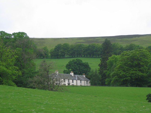
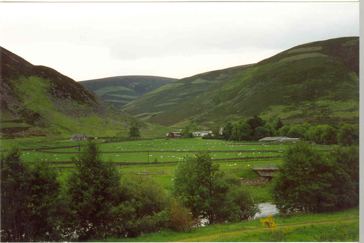
Dulyard Brae is a picturesque area located in Peeblesshire, a historic county in the Scottish Borders region of Scotland. Nestled amidst the undulating Downs and Moorland landscapes, Dulyard Brae offers a serene and idyllic setting for nature enthusiasts and outdoor adventurers.

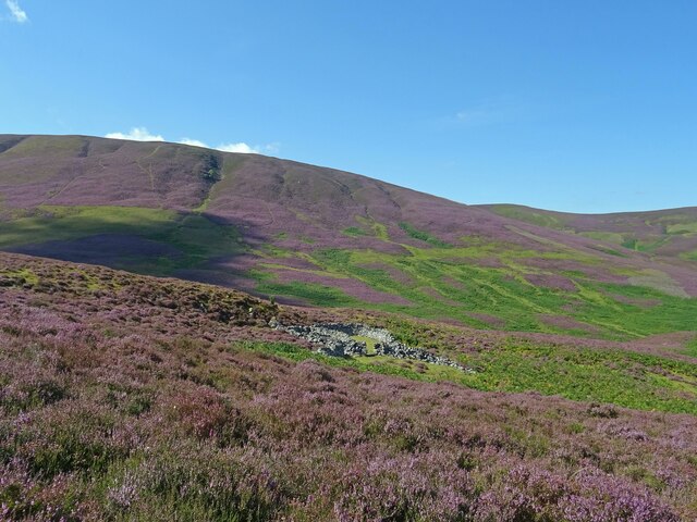
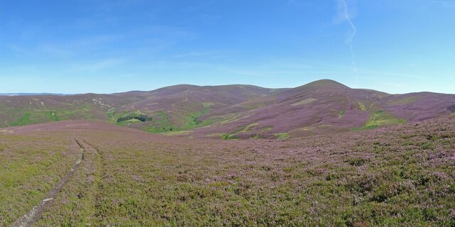
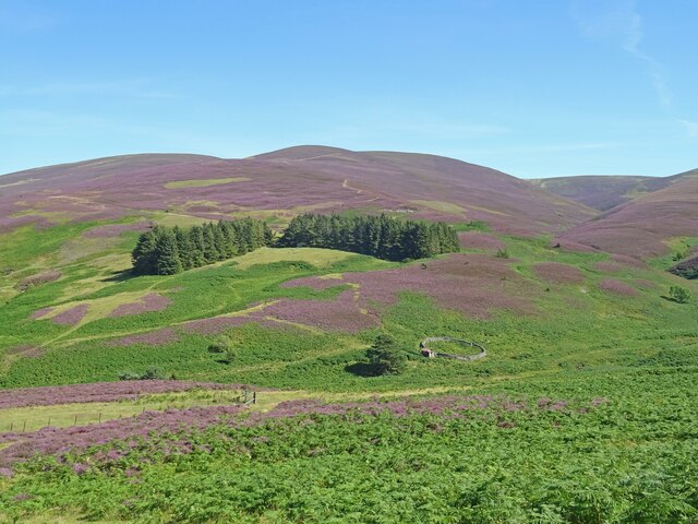
The area is characterized by its rolling hills, heather-clad moorlands, and breathtaking panoramic views. The Downs in Dulyard Brae are covered with lush grasses and dotted with vibrant wildflowers, creating a vibrant tapestry of colors during the warmer months. These gently sloping hills provide an excellent vantage point to observe the surrounding countryside and capture stunning photographs.

Moorland, on the other hand, adds a touch of ruggedness to the landscape. Its expansive stretches of heather, interspersed with patches of bog and peat, create a unique habitat for a diverse range of wildlife. Birdwatchers can spot various species of birds, including the majestic golden eagle and the elusive hen harrier, soaring above the moors.

For outdoor enthusiasts, Dulyard Brae offers ample opportunities for hiking, walking, and exploring. There are numerous trails and paths that wind through the Downs and Moorland, allowing visitors to immerse themselves in the natural beauty of the area. These trails cater to different skill levels, ensuring that everyone can enjoy a leisurely stroll or a more challenging hike.

Whether it's the tranquility of the moorland or the breathtaking views from the Downs, Dulyard Brae in Peeblesshire is a haven for those seeking a respite from the hustle and bustle of everyday life.

If you have any feedback on the listing, please let us know in the comments section below.

Dulyard Brae Images

Images are sourced within 2km of 55.570795/-3.3794411 or Grid Reference NT1331. Thanks to Geograph Open Source API. All images are credited.

At the top of Mossfennan Brae Looking down towards farmland by the River Tweed.
At the top of Mossfennan Brae
Looking down towards farmland by the River Tweed.
Gentle rise towards Wrae Hill A typical rounded Southern Uplands hill with a mix of grass and heather. A heavy shower is passing through not too far away, hence the dark clouds.
Gentle rise towards Wrae Hill
A typical rounded Southern Uplands hill with a mix of grass and heather. A heavy shower is passing through not too far away, hence the dark clouds.
Sheep grazing on Wrae Hill The distinctive conical shape of Worm Hill forms part of the backdrop.
Sheep grazing on Wrae Hill
The distinctive conical shape of Worm Hill forms part of the backdrop.
Lower Slopes of Drumelzier Law Lovely early autumnal/late summer colours in the hills south of Drumelzier.
The differing shades of purple showing that both Common Heather and Bell Heather are in abundance on the hills here.
Lower Slopes of Drumelzier Law
Lovely early autumnal/late summer colours in the hills south of Drumelzier. The differing shades of purple showing that both Common Heather and Bell Heather are in abundance on the hills here.
All around the bloomin' heather Heather in full bloom on the hills south of Drumelzier. A grand day to be out in the bloomin' heather though not sure there is wild mountain thyme about.
Very different colours to this scene from October 2020 from about the same spot.
<a title="https://www.geograph.org.uk/photo/6627939" href="https://www.geograph.org.uk/photo/6627939">Link</a>
All around the bloomin' heather
Heather in full bloom on the hills south of Drumelzier. A grand day to be out in the bloomin' heather though not sure there is wild mountain thyme about. Very different colours to this scene from October 2020 from about the same spot. Link
Heather in Full Bloom Sheepfold above the Drumelzier Burn and the lower slopes of Pykestone Hill seen from Finglen Rig. Heather in full bloom and very different to the relatively drab colours seen here in October 2020:-
<a title="https://www.geograph.org.uk/photo/6627953" href="https://www.geograph.org.uk/photo/6627953">Link</a>
Heather in Full Bloom
Sheepfold above the Drumelzier Burn and the lower slopes of Pykestone Hill seen from Finglen Rig. Heather in full bloom and very different to the relatively drab colours seen here in October 2020:- Link
Pykestone Hill and Drumelzier Law A circular hill walking loop is possible starting and finishing in the hamlet of Drumelzier.
Pykestone Hill and Drumelzier Law
A circular hill walking loop is possible starting and finishing in the hamlet of Drumelzier.
The hill of Craig Head, Stanhope
Deer seat, Hopekist Plantation Situated at a ride junction.
Deer seat, Hopekist Plantation
Situated at a ride junction.
Drumelzier Burn Steep V shaped valley running down to the Tweed. The track is used by shepherds to get around the vast acreage of sheepwalk on the surrounding hills.
Drumelzier Burn
Steep V shaped valley running down to the Tweed. The track is used by shepherds to get around the vast acreage of sheepwalk on the surrounding hills.
Drumelzier Burn Looking up the Drumelzier glen to Drumelzier Law (668m), a striking spur of the Tweedsmuir hill plateau.
Drumelzier Burn
Looking up the Drumelzier glen to Drumelzier Law (668m), a striking spur of the Tweedsmuir hill plateau.
Drumelzier Law The summit area. Constant exposure to wind keeps the vegetation close to the ground. Walk away from the ridge and deep heather returns.
Drumelzier Law
The summit area. Constant exposure to wind keeps the vegetation close to the ground. Walk away from the ridge and deep heather returns.
Floor of Tweeddale Hay meadows at Stanhope.
Floor of Tweeddale
Hay meadows at Stanhope.
Woodend The wooded knoll on the floor of Tweeddale is marked by the OS as an antiquity. As you can see this is very much sheep country.
Woodend
The wooded knoll on the floor of Tweeddale is marked by the OS as an antiquity. As you can see this is very much sheep country.
Mossfennan Large house in a bowl on the west side of Tweeddale. Above -grouse moors, below - improved grazing and the Tweed.
Mossfennan
Large house in a bowl on the west side of Tweeddale. Above -grouse moors, below - improved grazing and the Tweed.
Mother of all survey markers Dwarfing the conventional trig pillar, this monster (note rucksac for scale) on Worm Hill is a survey pillar for the Edinburgh Aqueduct. The aqueduct runs under the summit carrying water from Talla and Fruid reservoirs to the city.
Mother of all survey markers
Dwarfing the conventional trig pillar, this monster (note rucksac for scale) on Worm Hill is a survey pillar for the Edinburgh Aqueduct. The aqueduct runs under the summit carrying water from Talla and Fruid reservoirs to the city.
Wrae Wood A steep wooded area on the west side of Tweeddale.
Wrae Wood
A steep wooded area on the west side of Tweeddale.
Ford, Drumelzier River Tweed
Ford, Drumelzier
River Tweed
Show me another place!

Dulyard Brae is located at Grid Ref: NT1331 (Lat: 55.570795, Lng: -3.3794411)

Unitary Authority: The Scottish Borders

Police Authority: The Lothians and Scottish Borders

What 3 Words

///returns.professes.safe. Near Biggar, South Lanarkshire

Nearby Locations

Dulyard Brae Dulyard Brae

Related Wikis

Mossfennan

Mossfennan is a small settlement in southern Scotland near Drumelzier in the Scottish Borders, in the valley of the River Tweed. Mossfennan is a wooded...

Stanhope, Peeblesshire

Stanhope is a small settlement in the Scottish Borders region. It is situated in the parish of Drumelzier in Peeblesshire, in the valley of the River...

Wrae Tower

Wrae Tower is a ruined 16th-century stone tower house, located in the upper Tweed Valley in the Scottish Borders area of Scotland, and similarly south...

Drumelzier

Drumelzier (), is a village and civil parish on the B712 in the Tweed Valley in the Scottish Borders. The area of the village is extensive and includes...

Have you been to Dulyard Brae?

Leave your review of Dulyard Brae below (or comments, questions and feedback).