Braco Moss

Downs, Moorland in Kirkcudbrightshire

Scotland

Braco Moss

The A75 road from the air The short dual carriageway section at Drummore is obscured by cloud at the top of the photo. Lochfoot and Northpark are on the right. A pipeline is being laid across the road, section of the pipe can be seen in the trench to the left of the road.
The A75 road from the air Credit: Thomas Nugent

Braco Moss is a picturesque area located in Kirkcudbrightshire, Scotland. It is known for its stunning natural beauty, characterized by its rolling downs and vast moorland. Spread across an expansive area, Braco Moss offers visitors a serene and tranquil environment to explore and enjoy.

The downs of Braco Moss are covered in lush green grass and feature gentle slopes, creating a visually pleasing landscape. The area is home to a variety of plant species, including heather, gorse, and wildflowers, which add bursts of vibrant colors to the surroundings.

The moorland of Braco Moss is more rugged and wild, with vast stretches of open land. It is covered in heather and grasses, providing a habitat for various wildlife species. Visitors may spot birds such as curlews, lapwings, and plovers, as well as mammals like red deer and rabbits.

Walking and hiking enthusiasts are drawn to Braco Moss for its numerous trails and paths that wind through the downs and moorland. These routes offer breathtaking views of the surrounding countryside and provide opportunities for outdoor activities such as birdwatching, photography, and nature observation.

Braco Moss is also home to a small community, with a few farmhouses scattered throughout the area. The local residents contribute to the preservation of the natural environment and maintain the rural charm of the place.

Overall, Braco Moss in Kirkcudbrightshire is a captivating destination for nature lovers and those seeking a peaceful retreat. Its downs and moorland offer a harmonious blend of beauty and tranquility, making it an ideal spot to connect with nature and unwind.

If you have any feedback on the listing, please let us know in the comments section below.

Braco Moss Images

Images are sourced within 2km of 55.061674/-3.7564292 or Grid Reference NX8775. Thanks to Geograph Open Source API. All images are credited.

The A75 road from the air The short dual carriageway section at Drummore is obscured by cloud at the top of the photo. Lochfoot and Northpark are on the right. A pipeline is being laid across the road, section of the pipe can be seen in the trench to the left of the road.
The A75 road from the air
The short dual carriageway section at Drummore is obscured by cloud at the top of the photo. Lochfoot and Northpark are on the right. A pipeline is being laid across the road, section of the pipe can be seen in the trench to the left of the road.
The A75 road from the air The short dual carriageway section at Drummore is obscured by cloud at the top of the photo. Shealinghill is in the foreground, with Northpark beyond. A pipeline is being laid across the road, section of the pipe can be seen in the trench to the left of the road.
The A75 road from the air
The short dual carriageway section at Drummore is obscured by cloud at the top of the photo. Shealinghill is in the foreground, with Northpark beyond. A pipeline is being laid across the road, section of the pipe can be seen in the trench to the left of the road.
Henderland farm yard
Bogrie Lane from Bogrie Bridge
Driveway to Oakbank
Driveway to Oakbank
Minor road to Knockshinnoch
Old Milestone by Merkland, Lochrutton Parish Affleck by the A75, in parish of Lochrutton (Stewartry District), Merkland East of farm, on verge near hedge, North side of road.

Inscription reads:- : C / {arrow} / 12 : : D / {arrow} / 5¾ : 
(To Castle Douglas and Dumfries)

Surveyed

Milestone Society National ID: DG_PPLN78
Old Milestone by Merkland, Lochrutton Parish
Affleck by the A75, in parish of Lochrutton (Stewartry District), Merkland East of farm, on verge near hedge, North side of road. Inscription reads:- : C / {arrow} / 12 : : D / {arrow} / 5¾ : (To Castle Douglas and Dumfries) Surveyed Milestone Society National ID: DG_PPLN78
Route 75 Diner The A75 is a Primary Trunk Road; the main through route for traffic between northern England and Northern Ireland (more specifically the ferry terminal from Cairnryan to Belfast and Larne). It runs for 95½ miles between Stranraer and the A74(M) at Gretna, close to the Border with England and the M6 Motorway. Although it is an important trunk route (it is also a Euroroute, the E18), and has been subject to a number of upgrades over the years, the majority of the road is still single-carriageway although there are a few short dual carriageway sections and some three-lane sections which allow overtaking in one direction.
Route 75 Diner
The A75 is a Primary Trunk Road; the main through route for traffic between northern England and Northern Ireland (more specifically the ferry terminal from Cairnryan to Belfast and Larne). It runs for 95½ miles between Stranraer and the A74(M) at Gretna, close to the Border with England and the M6 Motorway. Although it is an important trunk route (it is also a Euroroute, the E18), and has been subject to a number of upgrades over the years, the majority of the road is still single-carriageway although there are a few short dual carriageway sections and some three-lane sections which allow overtaking in one direction.
A75 near Shawhead The A75 is a Primary Trunk Road; the main through route for traffic between northern England and Northern Ireland (more specifically the ferry terminal from Cairnryan to Belfast and Larne). It runs for 95½ miles between Stranraer and the A74(M) at Gretna, close to the Border with England and the M6 Motorway. Although it is an important trunk route (it is also a Euroroute, the E18), and has been subject to a number of upgrades over the years, the majority of the road is still single-carriageway although there are a few short dual carriageway sections and some three-lane sections which allow overtaking in one direction.
A75 near Shawhead
The A75 is a Primary Trunk Road; the main through route for traffic between northern England and Northern Ireland (more specifically the ferry terminal from Cairnryan to Belfast and Larne). It runs for 95½ miles between Stranraer and the A74(M) at Gretna, close to the Border with England and the M6 Motorway. Although it is an important trunk route (it is also a Euroroute, the E18), and has been subject to a number of upgrades over the years, the majority of the road is still single-carriageway although there are a few short dual carriageway sections and some three-lane sections which allow overtaking in one direction.
Eastbound A75 The A75 is a Primary Trunk Road; the main through route for traffic between northern England and Northern Ireland (more specifically the ferry terminal from Cairnryan to Belfast and Larne). It runs for 95½ miles between Stranraer and the A74(M) at Gretna, close to the Border with England and the M6 Motorway. Although it is an important trunk route (it is also a Euroroute, the E18), and has been subject to a number of upgrades over the years, the majority of the road is still single-carriageway although there are a few short dual carriageway sections and some three-lane sections which allow overtaking in one direction.
Eastbound A75
The A75 is a Primary Trunk Road; the main through route for traffic between northern England and Northern Ireland (more specifically the ferry terminal from Cairnryan to Belfast and Larne). It runs for 95½ miles between Stranraer and the A74(M) at Gretna, close to the Border with England and the M6 Motorway. Although it is an important trunk route (it is also a Euroroute, the E18), and has been subject to a number of upgrades over the years, the majority of the road is still single-carriageway although there are a few short dual carriageway sections and some three-lane sections which allow overtaking in one direction.
Near Henderland Farm Rough grazing near Henderland Farm.
Near Henderland Farm
Rough grazing near Henderland Farm.
Shawhead A small hamlet near Dumfries.
Shawhead
A small hamlet near Dumfries.
Old Cluden to Rosebank footpath Signeage on the Old Cluden to Rosebank footpath which is an old coffin road.
Old Cluden to Rosebank footpath
Signeage on the Old Cluden to Rosebank footpath which is an old coffin road.
Road to Shawhead Small unnamed road off the A75 to Shawhead.
Road to Shawhead
Small unnamed road off the A75 to Shawhead.
Henderland Looking along the A75 towards Dumfries with Deanside right of picture.
Henderland
Looking along the A75 towards Dumfries with Deanside right of picture.
Henderland Looking along the A75 towards Stranraer.
Henderland
Looking along the A75 towards Stranraer.
Henderland Looking over the A75 towards Barnbackle Hill.
Henderland
Looking over the A75 towards Barnbackle Hill.
Layby by Tara Looking along the A75 towards Stranraer.
Layby by Tara
Looking along the A75 towards Stranraer.
Show me another place!

Braco Moss is located at Grid Ref: NX8775 (Lat: 55.061674, Lng: -3.7564292)

Unitary Authority: Dumfries and Galloway

Police Authority: Dumfries and Galloway

What 3 Words

///depending.fuse.rags. Near Dumfries, Dumfries & Galloway

Related Wikis

Lochrutton Loch

Lochrutton Loch is a large, lowland freshwater loch that lies to the west of Dumfries, Scotland. The loch trends from north to south and is 0.75 mi (1...

Easthill stone circle

Easthill stone circle (grid reference NX91937388), also known as the Seven Grey Stanes, is a small oval stone circle 3¾ miles south-west of Dumfries. Eight...
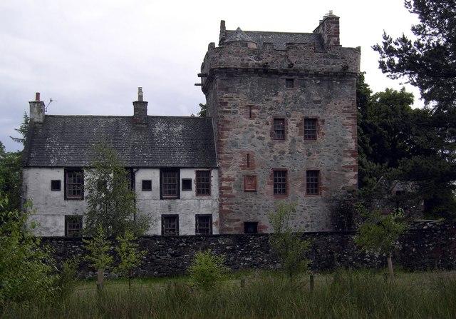
Hills Tower

Hills Tower is a sixteenth-century square tower house, with an adjoining eighteenth-century wing, near Dumfries in Scotland. Originally built around 1527...

Newtonairds railway station

Newtonairds (NX877801) was one of the principal stations on the now closed Cairn Valley Light Railway branch from Dumfries. It served a very rural area...

Glenkiln Sculpture Park

Glenkiln Sculpture Park was a sculpture landscape in the historic county of Kirkcudbrightshire in Dumfries and Galloway, south-west Scotland. After one...

Hallhill Covenanter Martyrs Memorial

The Hallhill Covenanter Martyrs Memorial at Irongray (NX 910797) near Kirkpatrick Irongray Church in the old county of Kirkcudbrightshire, now Dumfries...

Lochanhead railway station

Lochanhead railway station served the settlement of Lochanhead, Dumfries and Galloway, Scotland from 1859 to 1965 on the Castle Douglas and Dumfries Railway...

Crocketford

Crocketford (/ˈkrɒkɪtfɔːd/, also frequently /ˈkrɒkɪtfəd/) also known as Ninemile Bar (Scottish Gaelic: Ath Crogaid), as it is approximately equidistant...

Nearby Amenities

Located within 500m of 55.061674,-3.7564292
Power: pole
Lat/Long: 55.0577294/-3.7563409
Power: pole
Lat/Long: 55.0582758/-3.7574527
Power: pole
Lat/Long: 55.0588022/-3.7585238
Power: pole
Lat/Long: 55.0593271/-3.7596015
Power: pole
Lat/Long: 55.0598374/-3.760658
Power: pole
Lat/Long: 55.0603781/-3.7617739
Power: pole
Lat/Long: 55.06092/-3.7628834
Power: pole
Lat/Long: 55.0614716/-3.764012
Power: pole
Lat/Long: 55.0577537/-3.7581865
Power: pole
Lat/Long: 55.0649832/-3.7594604
The data included in this document is from www.openstreetmap.org. The data is made available under ODbL.

Have you been to Braco Moss?

Leave your review of Braco Moss below (or comments, questions and feedback).