Hadley

Settlement in Worcestershire Wychavon

England

Hadley

Farmland north of Ombersley Flat meadows as far as the eye can see
Farmland north of Ombersley Credit: Eirian Evans

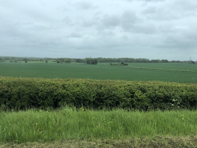
Hadley is a small village located in Worcestershire, England. Situated approximately 4 miles south of the town of Droitwich Spa, Hadley is nestled in a picturesque rural setting. The village is surrounded by rolling hills and lush green fields, offering stunning views of the Worcestershire countryside.

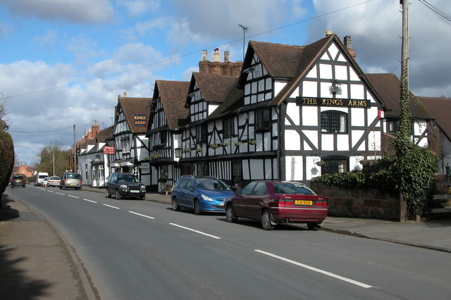
Hadley has a rich history that dates back many centuries. It is mentioned in the Domesday Book of 1086, highlighting its significance even in medieval times. The village has managed to retain its traditional charm, with many of its buildings showcasing beautiful architecture from different eras.

The heart of Hadley is its village green, a well-maintained open space that serves as a gathering point for locals. The green is often used for community events and activities, creating a strong sense of community spirit. In addition, Hadley has a quaint parish church, which is an architectural gem and a site of historical interest.

Although small in size, Hadley offers a range of amenities and services to its residents. These include a village hall, a primary school, and a local pub, which serves as a hub for socializing and enjoying traditional British cuisine.

For those looking to explore the surrounding area, Hadley is conveniently located near several attractions. The nearby town of Droitwich Spa offers a variety of shops, restaurants, and leisure facilities, while the vibrant city of Worcester is within easy reach, providing further entertainment and cultural opportunities.

In summary, Hadley is a charming village with a rich history and a strong sense of community. Its idyllic location and proximity to larger towns make it an appealing place to live for those seeking a peaceful and picturesque setting.

If you have any feedback on the listing, please let us know in the comments section below.

Hadley Images

Images are sourced within 2km of 52.271692/-2.205142 or Grid Reference SO8663. Thanks to Geograph Open Source API. All images are credited.

Farmland north of Ombersley Flat meadows as far as the eye can see
Farmland north of Ombersley
Flat meadows as far as the eye can see
Old Bridge Marker on the A4133 Bridge Marker inscribed in the north parapet of Ward's Bridge, Hadley Brook, on the A4133. On the boundary of Ombersley, Westwood and Salwarpe parishes.

Milestone Society National ID: WO_OMWESA01br
Old Bridge Marker on the A4133
Bridge Marker inscribed in the north parapet of Ward's Bridge, Hadley Brook, on the A4133. On the boundary of Ombersley, Westwood and Salwarpe parishes. Milestone Society National ID: WO_OMWESA01br
Locals at Mayhouse Farm Rescued cows at the farm.
Locals at Mayhouse Farm
Rescued cows at the farm.
Ombersley Court from the footpath by the fishponds
St Andrews Church, Ombersley from the South West
Old Milestone, A449, South of Ombersley The milestone is located 20m north of the junction with the A4133 old road through Ombersley on the grass verge on the west side of the road. Parish of Ombersley (Wychavon District). Concrete post with replacement metal plate, Bradley post design, originally erected by the County Council in the 1930's. 

The original plate was stolen by professional thieves in April 2019, see <a title="https://www.geograph.org.uk/photo/6583401" href="https://www.geograph.org.uk/photo/6583401">Link</a> . The replacement plate was provided by the Milestone Society in October 2021, funded by a bequest from society member Rob Bubb of Kidderminster, being painstakingly installed by Worcestershire Highways staff, with additional refurbishment by the Ombersley and Doverdale Parish Council.

Inscription reads:-
A449 / STOURPORT 7 / C.C.W.

Milestone Society National ID: WO_SPWO07
Old Milestone, A449, South of Ombersley
The milestone is located 20m north of the junction with the A4133 old road through Ombersley on the grass verge on the west side of the road. Parish of Ombersley (Wychavon District). Concrete post with replacement metal plate, Bradley post design, originally erected by the County Council in the 1930's. The original plate was stolen by professional thieves in April 2019, see Link . The replacement plate was provided by the Milestone Society in October 2021, funded by a bequest from society member Rob Bubb of Kidderminster, being painstakingly installed by Worcestershire Highways staff, with additional refurbishment by the Ombersley and Doverdale Parish Council. Inscription reads:- A449 / STOURPORT 7 / C.C.W. Milestone Society National ID: WO_SPWO07
Tolley Memorial in the churchyard, Ombersley Early 19th century chest tomb commemorating Henry Godfrey Tolley, died 1822. Listed Grade II.
Tolley Memorial in the churchyard, Ombersley
Early 19th century chest tomb commemorating Henry Godfrey Tolley, died 1822. Listed Grade II.
Churchyard wall and gates, Ombersley These are c1830 and Listed Grade II.
Churchyard wall and gates, Ombersley
These are c1830 and Listed Grade II.
Pardoe Memorial, St Andrew's churchyard, Ombersley A disintegrating early 19th century chest tomb for Richard Pardoe, died 1807. Listed Grade II.
Pardoe Memorial, St Andrew's churchyard, Ombersley
A disintegrating early 19th century chest tomb for Richard Pardoe, died 1807. Listed Grade II.
Pedestal tomb in St Andrew's churchyard, Ombersley Early 19th century in sandstone ashlar and Listed Grade II. The inscriptions are illegible.
Pedestal tomb in St Andrew's churchyard, Ombersley
Early 19th century in sandstone ashlar and Listed Grade II. The inscriptions are illegible.
Watkins Memorial, St Andrew's Churchyard, Ombersley Early 19th century in sandstone ashlar with panels commemorating Mary Watkins, died 1816, and John Watkins, died 1833. Listed Grade II. The Sandys Mausoleum is in the left background.
Watkins Memorial, St Andrew's Churchyard, Ombersley
Early 19th century in sandstone ashlar with panels commemorating Mary Watkins, died 1816, and John Watkins, died 1833. Listed Grade II. The Sandys Mausoleum is in the left background.
Watkins Memorial, St Andrew's Churchyard, Ombersley This is the other Watkins Memorial and is a pedestal tomb from the mid-19th century in sandstone ashlar. One face commemorates Anne Watkins, died 1844. Listed Grade II.
Watkins Memorial, St Andrew's Churchyard, Ombersley
This is the other Watkins Memorial and is a pedestal tomb from the mid-19th century in sandstone ashlar. One face commemorates Anne Watkins, died 1844. Listed Grade II.
Sandys Mausoleum, St Andrew's churchyard, Ombersley Part of an old parish church that is now a mausoleum. Late 13th century with c1830 alterations. Listed Grade II*.
Sandys Mausoleum, St Andrew's churchyard, Ombersley
Part of an old parish church that is now a mausoleum. Late 13th century with c1830 alterations. Listed Grade II*.
Shaw Memorial, St Andrew's churchyard, Ombersley Chest tomb of c1832 to commemorate Thomas Shaw, died 1832. Listed Grade II.
Shaw Memorial, St Andrew's churchyard, Ombersley
Chest tomb of c1832 to commemorate Thomas Shaw, died 1832. Listed Grade II.
Churchyard Cross, St Andrew's churchyard, Ombersley Late 15th century with later alterations. Listed Grade II.
Churchyard Cross, St Andrew's churchyard, Ombersley
Late 15th century with later alterations. Listed Grade II.
Pedestal Tomb, St Andrew's churchyard, Ombersley Pedestal tomb late 18th/early 19th century. Listed Grade II.
Pedestal Tomb, St Andrew's churchyard, Ombersley
Pedestal tomb late 18th/early 19th century. Listed Grade II.
Bourne Family Headstone, St Andrew's churchyard, Ombersley Mid-18th century cast-iron gravestone with a visible date of 1762. Commemorates Mary and Alice wives of Henry Bourne. Listed Grade II.
Bourne Family Headstone, St Andrew's churchyard, Ombersley
Mid-18th century cast-iron gravestone with a visible date of 1762. Commemorates Mary and Alice wives of Henry Bourne. Listed Grade II.
Wheeler Memorial, St Andrew's churchyard, Ombersley Mid-18th century chest tomb in sandstone ashlar. Commemorates Mary Wheeler, died 1771. Listed Grade II.
Wheeler Memorial, St Andrew's churchyard, Ombersley
Mid-18th century chest tomb in sandstone ashlar. Commemorates Mary Wheeler, died 1771. Listed Grade II.
Show me another place!

Hadley is located at Grid Ref: SO8663 (Lat: 52.271692, Lng: -2.205142)

Administrative County: Worcestershire

District: Wychavon

Police Authority: West Mercia

What 3 Words

///nervy.lurching.start. Near Droitwich, Worcestershire

Nearby Locations

Hadley

Related Wikis

Doverdale

Doverdale is a small village and civil parish in Worcestershire, England, to the west of Droitwich. It has a parish church. Doverdale Manor is one of largest...

Westwood House

Westwood House is a stately home, near Droitwich, Worcestershire, England. It has been subdivided into twelve self-contained apartments. The house has...

Ombersley

Ombersley is a village and civil parish in Wychavon district, in the county of Worcestershire, England. The parish includes the hamlet of Holt Fleet,...

Ombersley and Doverdale

Ombersley and Doverdale is an area in Wychavon district, Worcestershire, England served by a single parish council but comprising the two separate civil...

Nearby Amenities

Located within 500m of 52.271692,-2.205142
Hadley
Is In: Worcester
Place: hamlet
Lat/Long: 52.2712592/-2.2050579
Hadley- Telephone Box
Naptan AtcoCode: 2000G056700
Naptan Bearing: W
Naptan BusStopType: CUS
Naptan CommonName: Hadley- Telephone Box
Naptan Indicator: Adj
Naptan Landmark: Brickhouse Farm Lane
Naptan NaptanCode: wocdjgda
Naptan Street: Droitwich Road (A4133)
Naptan Verified: no
Source: naptan_import
Lat/Long: 52.2697544/-2.2041409
Nurseries
Naptan AtcoCode: 2000G663008
Naptan Bearing: SE
Naptan BusStopType: CUS
Naptan CommonName: Nurseries
Naptan Indicator: opp
Naptan Landmark: Hadley Farm
Naptan NaptanCode: wocgamta
Naptan Street: A4133 Ombersley Road
Naptan Verified: no
Source: naptan_import
Lat/Long: 52.2712677/-2.2076504
Barrier: stile
Foot: yes
Lat/Long: 52.2681698/-2.2062567
Post Box
Collection Times: Mo-Fr 15:45; Sa 09:45
Old Ref: D.381 Hadley
Post Box Type: lamp
Ref: WR9 381
Royal Cypher: EIIR
Royal Cypher Wikidata: Q33102113
Source Old Ref: collection plate
Source Ref: dracos
Lat/Long: 52.2697419/-2.2043948
Barrier: cattle_grid
Lat/Long: 52.2701481/-2.2062197
Power: pole
Lat/Long: 52.2751403/-2.2039282
Power: pole
Lat/Long: 52.2723203/-2.2013841
Barrier: stile
Foot: yes
Lat/Long: 52.2721398/-2.201559
Hadley Bungalow
Power: pole
Transformer: distribution
Voltage Primary: 11000
Lat/Long: 52.2730609/-2.1987997
Location Transition: yes
Power: pole
Lat/Long: 52.2698735/-2.202807
Power: pole
Lat/Long: 52.2760406/-2.2041242
Power: pole
Lat/Long: 52.2725639/-2.200568
Power: pole
Lat/Long: 52.2716124/-2.2022125
Power: pole
Lat/Long: 52.2710241/-2.2071714
Power: pole
Lat/Long: 52.2705531/-2.2024498
Power: pole
Lat/Long: 52.2721314/-2.2020845
Power: pole
Lat/Long: 52.2709436/-2.2079367
Power: pole
Lat/Long: 52.2733239/-2.202812
Fixme: continue
Lat/Long: 52.2736662/-2.2002112
Power: pole
Lat/Long: 52.2716349/-2.203752
Power: pole
Lat/Long: 52.2701471/-2.2028436
Power: pole
Lat/Long: 52.2727258/-2.2024464
Hadley Farm
Power: pole
Transformer: distribution
Voltage Primary: 11000
Lat/Long: 52.2708775/-2.2086638
Power: pole
Lat/Long: 52.2728829/-2.1994266
Tile House
Power: pole
Transformer: distribution
Voltage Primary: 11000
Lat/Long: 52.2739123/-2.2031765
Power: pole
Lat/Long: 52.2704716/-2.2085206
Power: pole
Lat/Long: 52.2745247/-2.2035584
Fixme: continue
Lat/Long: 52.2750251/-2.2008746
Power: pole
Lat/Long: 52.2710843/-2.2023356
Power: pole
Lat/Long: 52.2711887/-2.205407
Power: pole
Lat/Long: 52.2693213/-2.2026745
Location Transition: yes
Power: pole
Lat/Long: 52.2701263/-2.2084084
Brickhouse Farm
Power: pole
Transformer: distribution
Voltage Primary: 11000
Lat/Long: 52.2690662/-2.2035365
Barrier: stile
Foot: yes
Lat/Long: 52.2704526/-2.2029362
Power: pole
Lat/Long: 52.2733903/-2.1999384
Hadley Mill
Power: pole
Transformer: distribution
Voltage Primary: 11000
Lat/Long: 52.2744239/-2.1998298
Power: pole
Lat/Long: 52.2738544/-2.2003515
The Cross
Power: pole
Transformer: distribution
Voltage Primary: 11000
Lat/Long: 52.2726013/-2.2068653
Power: pole
Lat/Long: 52.2721532/-2.2064066
Power: pole
Lat/Long: 52.2716699/-2.2059117
Southernwood
Power: pole
Transformer: distribution
Voltage Primary: 11000
Lat/Long: 52.270633/-2.2035058
Osmonds
Power: pole
Transformer: distribution
Voltage Primary: 11000
Lat/Long: 52.2704758/-2.2004226
Power: pole
Lat/Long: 52.2703494/-2.20136
The data included in this document is from www.openstreetmap.org. The data is made available under ODbL.

Have you been to Hadley?

Leave your review of Hadley below (or comments, questions and feedback).