Haconby

Settlement in Lincolnshire South Kesteven

England

Haconby

St.John the Baptist's church, Morton, Lincs. A grand cruciform church looking down on the village of Morton. Perpendicular tower, decorated chancel and south arcade, but the 4 bay north arcade is late 13th century Early English and has particularly good capitals.
St.John the Baptist's church, Morton, Lincs. Credit: Richard Croft

Haconby is a small village located in the South Kesteven district of Lincolnshire, England. Situated approximately 10 miles east of the market town of Stamford, Haconby is a peaceful rural settlement with a population of around 300 residents.

The village is known for its picturesque countryside, characterized by rolling hills and lush farmland. Haconby is surrounded by other small villages, creating a tight-knit community that is proud of its heritage and traditions. The village itself retains much of its historic charm, with many well-preserved stone cottages and buildings that date back several centuries.

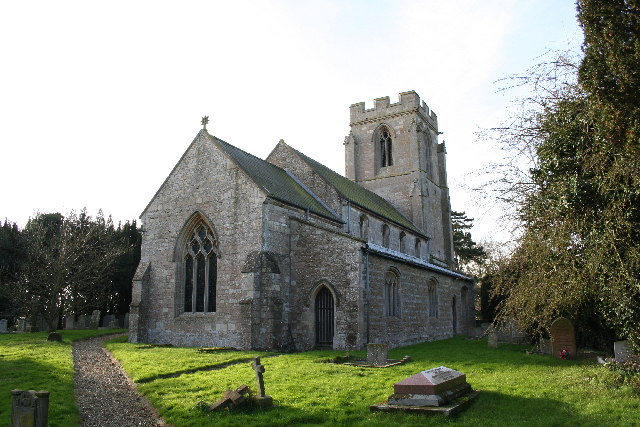
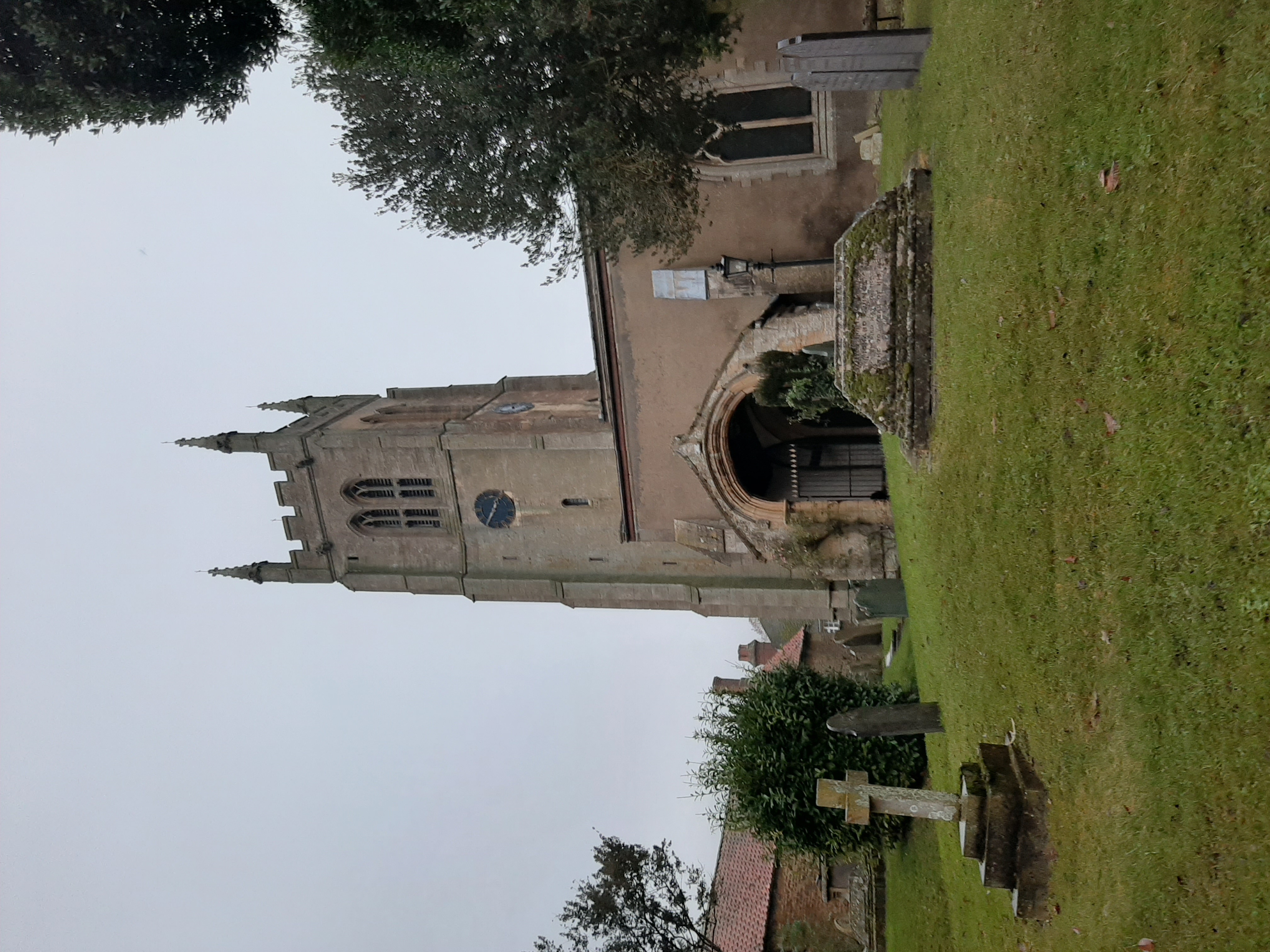
Despite its small size, Haconby offers a few amenities to its residents. The village has a local pub, The Hare & Hounds, which serves as a social hub for both locals and visitors alike. Additionally, there is a primary school, St. Gilbert's Church, and a village hall that hosts various community events throughout the year.

The surrounding area provides ample opportunities for outdoor activities. Haconby is situated near the River Glen, which is popular for fishing and boating. The nearby countryside offers scenic walking and cycling routes, allowing residents to enjoy the beauty of nature at their doorstep.

Overall, Haconby is a charming village that provides a quiet and idyllic lifestyle for its residents. Its rural setting, historic architecture, and sense of community make it a desirable place to live for those seeking a quaint village atmosphere in Lincolnshire.

If you have any feedback on the listing, please let us know in the comments section below.

Haconby Images

Images are sourced within 2km of 52.815148/-0.361576 or Grid Reference TF1025. Thanks to Geograph Open Source API. All images are credited.

St.John the Baptist's church, Morton, Lincs. A grand cruciform church looking down on the village of Morton. Perpendicular tower, decorated chancel and south arcade, but the 4 bay north arcade is late 13th century Early English and has particularly good capitals.
St.John the Baptist's church, Morton, Lincs.
A grand cruciform church looking down on the village of Morton. Perpendicular tower, decorated chancel and south arcade, but the 4 bay north arcade is late 13th century Early English and has particularly good capitals.
Morton Village On the junction with the A15 trunk road.
Morton Village
On the junction with the A15 trunk road.
Footpath to Stainfield This footpath leads from the A15 to Stainfield.
Footpath to Stainfield
This footpath leads from the A15 to Stainfield.
Morton church Morton church on a sunny November afternoon
Morton church
Morton church on a sunny November afternoon
Public footpath Looking towards Dunsby from the stile on the A15. Standing in the shadow of Dunsby Wood on a bright January afternoon.
Public footpath
Looking towards Dunsby from the stile on the A15. Standing in the shadow of Dunsby Wood on a bright January afternoon.
Looking towards Bourne on the A15 Dunsby Wood on the right.
Looking towards Bourne on the A15
Dunsby Wood on the right.
Dunsby Wood This large mixed woodland is part of a string of woodland across this part of Lincolnshire. It is commercially managed for timber and this section is mainly oak. Taken from the public bridleway.
Dunsby Wood
This large mixed woodland is part of a string of woodland across this part of Lincolnshire. It is commercially managed for timber and this section is mainly oak. Taken from the public bridleway.
Dunsby Wood Low winter sunshine streaming through the conifers in this part felled area in the centre of Dunsby Wood, a mixed private woodland north of Stainfield. Younger trees can be seen beyond.
Taken from the private gated entrance off the public bridleway which skirts the woodland on its way to Glebe Farm.
Dunsby Wood
Low winter sunshine streaming through the conifers in this part felled area in the centre of Dunsby Wood, a mixed private woodland north of Stainfield. Younger trees can be seen beyond. Taken from the private gated entrance off the public bridleway which skirts the woodland on its way to Glebe Farm.
Morton Church, at night The church, at the eastern end of High Street, is illuminated each night by intense lamps at ground level - which should prevent theft from the church.
Morton Church, at night
The church, at the eastern end of High Street, is illuminated each night by intense lamps at ground level - which should prevent theft from the church.
A roof over his head The Kings Head at Morton has had a temporary roof installed following severe damage by fire
A roof over his head
The Kings Head at Morton has had a temporary roof installed following severe damage by fire
Morton Village Hall
Morton Village Hall
Hulme Farm, High Street, Morton Most older buildings on the High Street are built in the traditional local yellow limestone
Hulme Farm, High Street, Morton
Most older buildings on the High Street are built in the traditional local yellow limestone
Morton - Village Store and Post Office Note the modern style of post-mounted post box
Morton - Village Store and Post Office
Note the modern style of post-mounted post box
New Day Baptist Church, Morton This brick built chapel contrasts with the general use of local stone for buildings in the High Street. Even the thatched cottage to the right is a one-off.
New Day Baptist Church, Morton
This brick built chapel contrasts with the general use of local stone for buildings in the High Street. Even the thatched cottage to the right is a one-off.
Morton High Street The round towers to the right flank the entrance to Morton Grange
Morton High Street
The round towers to the right flank the entrance to Morton Grange
With the Delaine to Peterborough - Morton High Street Delaine Buses provide Morton with an hourly link to Peterborough.
See grid square discussion <a title="https://www.geograph.org.uk/discuss/index.php?&action=vthread&forum=5&topic=7047" href="https://www.geograph.org.uk/discuss/index.php?&action=vthread&forum=5&topic=7047">Link</a> and slide show <a title="https://www.geograph.org.uk/search.php?i=2189430" href="https://www.geograph.org.uk/search.php?i=2189430">Link</a>
With the Delaine to Peterborough - Morton High Street
Delaine Buses provide Morton with an hourly link to Peterborough. See grid square discussion Link and slide show Link
With the Delaine to Peterborough - Morton This is the end of the route. The driver has a few minutes wait before commencing his run to Peterborough via Bourne and The Deepings
See grid square discussion <a title="https://www.geograph.org.uk/discuss/index.php?&action=vthread&forum=5&topic=7047" href="https://www.geograph.org.uk/discuss/index.php?&action=vthread&forum=5&topic=7047">Link</a> and slide show <a title="https://www.geograph.org.uk/search.php?i=2189430" href="https://www.geograph.org.uk/search.php?i=2189430">Link</a>
With the Delaine to Peterborough - Morton
This is the end of the route. The driver has a few minutes wait before commencing his run to Peterborough via Bourne and The Deepings See grid square discussion Link and slide show Link
With the Delaine to Peterborough - Morton Church 5 minutes to go by the church clock before departing to Peterborough.
See grid square discussion <a title="https://www.geograph.org.uk/discuss/index.php?&action=vthread&forum=5&topic=7047" href="https://www.geograph.org.uk/discuss/index.php?&action=vthread&forum=5&topic=7047">Link</a> and slide show <a title="https://www.geograph.org.uk/search.php?i=2189430" href="https://www.geograph.org.uk/search.php?i=2189430">Link</a>
With the Delaine to Peterborough - Morton Church
5 minutes to go by the church clock before departing to Peterborough. See grid square discussion Link and slide show Link
Show me another place!

Haconby is located at Grid Ref: TF1025 (Lat: 52.815148, Lng: -0.361576)

Division: Parts of Kesteven

Administrative County: Lincolnshire

District: South Kesteven

Police Authority: Lincolnshire

What 3 Words

///goose.mulls.brains. Near Bourne, Lincolnshire

Nearby Locations

Haconby

Related Wikis

Haconby

Haconby is a village and civil parish in the South Kesteven district of Lincolnshire, England. The population of the civil parish at the 2001 census was...

Dunsby

Dunsby is a small village and civil parish in the South Kesteven district of in Lincolnshire, England. It is 4 miles (6.4 km) north from Bourne, just east...

Morton Road railway station

Morton Road railway station was a station serving the village of Morton, Lincolnshire on the Great Northern Railway Bourne and Sleaford railway. It opened...

Morton and Hanthorpe

Morton and Hanthorpe is a civil parish, formerly known as Morton by Bourne in the South Kesteven district of Lincolnshire, England. It is situated 2 miles...

St Andrew's Church, Rippingale

The Church of St Andrew in Rippingale, Lincolnshire, England, is a Grade Iā€“listed Anglican church. The earliest phase of the church dates back to the mid...

Rippingale

Rippingale is a village and civil parish in the South Kesteven district of Lincolnshire, England. The population of the civil parish was 929 at the 2011...

Stainfield near Bourne

Stainfield is a hamlet in the South Kesteven district of Lincolnshire, England. It is 3 miles (5 km) north from Bourne and 1 mile (1.6 km) west from the...

Dyke, Lincolnshire

Dyke is a village in the South Kesteven district of Lincolnshire, England. It is situated less than 1 mile (1.6 km) east from the A15 road, and approximately...

Nearby Amenities

Located within 500m of 52.815148,-0.361576
Haconby
Is In: Lincolnshire, England, UK
Old Name: Hacconby
Place: village
Lat/Long: 52.8144993/-0.3617334
Bus Stop
Hall Road Shelter
Bus: yes
Naptan AtcoCode: 270000014574
Naptan Bearing: S
Naptan CommonName: Hall Road Shelter
Naptan Landmark: Shelter
Naptan NaptanCode: linjpwpt
Naptan Street: Hall Road
Naptan Verified: no
Public Transport: platform
Source: naptan_import
Lat/Long: 52.8142645/-0.3641523
Bus Stop
Hall Road Shelter
Bus: yes
Naptan AtcoCode: 270000014575
Naptan Bearing: N
Naptan CommonName: Hall Road Shelter
Naptan Indicator: opp
Naptan Landmark: Shelter
Naptan NaptanCode: linjpwpw
Naptan Street: Hall Road
Naptan Verified: no
Public Transport: platform
Source: naptan_import
Lat/Long: 52.8142394/-0.3642868
Bus Stop
The Sportsman PH
Bus: yes
Naptan AtcoCode: 270002700409
Naptan Bearing: W
Naptan CommonName: The Sportsman PH
Naptan Indicator: W - bound
Naptan Landmark: The Sportsman PH
Naptan Street: Main Street
Naptan Verified: no
Public Transport: platform
Source: naptan_import
Lat/Long: 52.8146513/-0.3648204
Bus Stop
The Sportsman PH
Bus: yes
Naptan AtcoCode: 270002700410
Naptan Bearing: E
Naptan CommonName: The Sportsman PH
Naptan Indicator: E - bound
Naptan Landmark: The Sportsman PH
Naptan Street: Main Street
Naptan Verified: no
Public Transport: platform
Source: naptan_import
Lat/Long: 52.8147412/-0.364817
Bus Stop
Main Street Telephone Box
Bus: yes
Naptan AtcoCode: 2700LHBS2267
Naptan Bearing: NE
Naptan CommonName: Main Street Telephone Box
Naptan Landmark: Telephone Box
Naptan NaptanCode: linapmpa
Naptan Street: Main Street
Naptan Verified: no
Public Transport: platform
Source: naptan_import
Lat/Long: 52.8150401/-0.3623722
Place Of Worship
Baptist Chapel
Denomination: baptist
Religion: christian
Lat/Long: 52.8151709/-0.3597274
Pub
Hare and Hounds
Addr City: Bourne
Addr Country: GB
Addr Housenumber: 2
Addr Postcode: PE10 0UZ
Addr Street: West Road
Addr Suburb: Haconby
Fhrs Authority: South Kesteven
Fhrs Id: 238493
Fhrs Local Authority Id: 4761
Lat/Long: 52.814764/-0.3645383
Archaeological Site: fortification
Historic: archaeological_site
Source: Bing
Lat/Long: 52.8143071/-0.3576256
Power: pole
Lat/Long: 52.8160845/-0.3688174
Removed Amenity: telephone
Lat/Long: 52.8150658/-0.3620941
Post Box
Post Box Type: lamp
Lat/Long: 52.8150748/-0.3620673
The data included in this document is from www.openstreetmap.org. The data is made available under ODbL.

Have you been to Haconby?

Leave your review of Haconby below (or comments, questions and feedback).