Brent Moor

Downs, Moorland in Devon South Hams

England

Brent Moor

Trig Point and Carn, Three Barrows
Trig Point and Carn, Three Barrows Credit: Chris Andrews

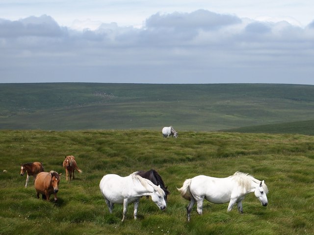
Brent Moor is a picturesque area located in Devon, England. It is situated on the eastern edge of Dartmoor National Park, surrounded by rolling hills and stunning natural beauty. The moor is characterized by its open grassland, interspersed with patches of heather and gorse bushes.

Covering an expansive area of approximately 2 square kilometers, Brent Moor is known for its rich biodiversity and unique flora and fauna. The moorland is home to a variety of bird species, including skylarks, stonechats, and meadow pipits, making it a popular destination for birdwatchers.

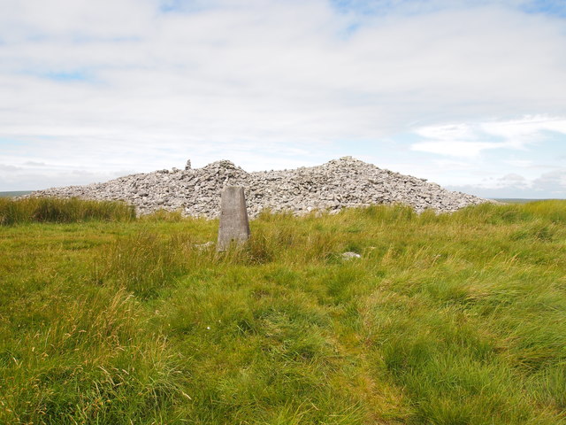
The landscape of Brent Moor is largely influenced by its geology, with granite outcrops and tors scattered throughout the area. These rocky formations provide a dramatic backdrop against the vast expanse of greenery. The most prominent tors on Brent Moor are Sharpitor and Peek Hill, which offer breathtaking panoramic views of the surrounding countryside.

The moorland is crisscrossed by a network of footpaths and bridleways, allowing visitors to explore its beauty on foot, bicycle, or horseback. It is a popular destination for outdoor enthusiasts, offering ample opportunities for hiking, wildlife spotting, and photography.

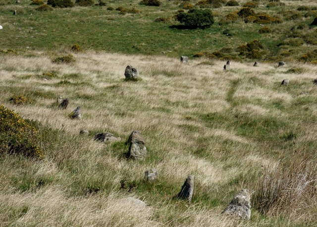
Brent Moor also holds historical significance, with evidence of prehistoric settlements and ancient burial sites. The area is dotted with stone circles and cairns, providing a glimpse into the region's rich heritage.

Overall, Brent Moor is a captivating destination that showcases the natural beauty and cultural history of Devon. Its tranquil atmosphere and stunning vistas make it a must-visit for nature lovers and those seeking a peaceful retreat.

If you have any feedback on the listing, please let us know in the comments section below.

Brent Moor Images

Images are sourced within 2km of 50.452003/-3.8756352 or Grid Reference SX6663. Thanks to Geograph Open Source API. All images are credited.

Trig Point and Carn, Three Barrows
Ponies on Three Barrows
River Avon upstream of Shipley Bridge
Wall by the ford at Shipley Bridge There isn't much water about today and the ford isn't over the road. The fields here are the last before 
the unfenced moorland begins.
Wall by the ford at Shipley Bridge
There isn't much water about today and the ford isn't over the road. The fields here are the last before the unfenced moorland begins.
Marshy patch at Shipley Bridge Right on the edge of Dartmoor proper here. Facing this way it's green fields and woods but just behind me are the gorse and bracken covered slopes of the unfenced moorland.
Marshy patch at Shipley Bridge
Right on the edge of Dartmoor proper here. Facing this way it's green fields and woods but just behind me are the gorse and bracken covered slopes of the unfenced moorland.
Zeal Gully A short tributary joining the River Avon a short way downstream from the reservoir dam.
Zeal Gully
A short tributary joining the River Avon a short way downstream from the reservoir dam.
A little bit of bog Not one of Dartmoor's famous quagmires, just a bit of seepage at the bottom of the hill by the River Avon.
A little bit of bog
Not one of Dartmoor's famous quagmires, just a bit of seepage at the bottom of the hill by the River Avon.
Towards Brent Moor The west side of the Avon Valley towards the higher ground of Brent Moor.
Towards Brent Moor
The west side of the Avon Valley towards the higher ground of Brent Moor.
Ruins of Brent Moor House The house was demolished in 1968. This is all that remains.
Ruins of Brent Moor House
The house was demolished in 1968. This is all that remains.
River Avon, Shipley Bridge
River Avon, Near Shipley Bridge
Gauging Station, River Avon
River Avon Looking upstream, below Black Brake.
River Avon
Looking upstream, below Black Brake.
River Avon Upstream from Shipley Bridge.
River Avon
Upstream from Shipley Bridge.
Black Tor prehistoric stone row A double prehistoric stone row measuring 56m long, including at least 22 small-sized stones. The row is orientated north west to south east and there is a cairn at the upper northern western end. <span class="nowrap"><a title="https://stonerows.wordpress.com/gazetteer/region/dartmoor/black-tor-avon-stone-row/" rel="nofollow ugc noopener" href="https://stonerows.wordpress.com/gazetteer/region/dartmoor/black-tor-avon-stone-row/">Link</a><img style="margin-left:2px;" alt="External link" title="External link - shift click to open in new window" src="https://s1.geograph.org.uk/img/external.png" width="10" height="10"/></span>
Black Tor prehistoric stone row
A double prehistoric stone row measuring 56m long, including at least 22 small-sized stones. The row is orientated north west to south east and there is a cairn at the upper northern western end. LinkExternal link
Brent Fore Hill prehistoric stone row A double prehistoric stone row measuring 120m long, including at least 32 small and medium-sized stones. The row is orientated north east to south west and there is a kerbed cairn at the upper north eastern end. <span class="nowrap"><a title="https://stonerows.wordpress.com/gazetteer/region/dartmoor/brent-fore-hill/" rel="nofollow ugc noopener" href="https://stonerows.wordpress.com/gazetteer/region/dartmoor/brent-fore-hill/">Link</a><img style="margin-left:2px;" alt="External link" title="External link - shift click to open in new window" src="https://s1.geograph.org.uk/img/external.png" width="10" height="10"/></span>
Brent Fore Hill prehistoric stone row
A double prehistoric stone row measuring 120m long, including at least 32 small and medium-sized stones. The row is orientated north east to south west and there is a kerbed cairn at the upper north eastern end. LinkExternal link
Corringdon Ball, North prehistoric stone row A single prehistoric stone row measuring 132m long, including at least 21 small and medium-sized stones. The row is orientated north east to south west and there is a kerbed cairn at the lower north eastern end. The large stone in the middle distance forms part of the kerbed cairn at the end of this row. The stones to the right form part of Corringdon Ball, South stone row and its terminal cairn. <span class="nowrap"><a title="https://stonerows.wordpress.com/gazetteer/region/dartmoor/corringdon-ball-north/" rel="nofollow ugc noopener" href="https://stonerows.wordpress.com/gazetteer/region/dartmoor/corringdon-ball-north/">Link</a><img style="margin-left:2px;" alt="External link" title="External link - shift click to open in new window" src="https://s1.geograph.org.uk/img/external.png" width="10" height="10"/></span>
Corringdon Ball, North prehistoric stone row
A single prehistoric stone row measuring 132m long, including at least 21 small and medium-sized stones. The row is orientated north east to south west and there is a kerbed cairn at the lower north eastern end. The large stone in the middle distance forms part of the kerbed cairn at the end of this row. The stones to the right form part of Corringdon Ball, South stone row and its terminal cairn. LinkExternal link
Corringdon Ball, South prehistoric stone row A multiple prehistoric stone row measuring 178m long, including at least 247 mainly small-sized together with some medium-sized stones arranged in at least 7 separate lines. The row is orientated north east to south west and there is a kerbed cairn at the lower north eastern end. This row is of a rare multiple row type, consisting as it does of parallel lines of stones rather than the usual fan-shaped arrangement. <span class="nowrap"><a title="https://stonerows.wordpress.com/gazetteer/region/dartmoor/corringdon-ball-south/" rel="nofollow ugc noopener" href="https://stonerows.wordpress.com/gazetteer/region/dartmoor/corringdon-ball-south/">Link</a><img style="margin-left:2px;" alt="External link" title="External link - shift click to open in new window" src="https://s1.geograph.org.uk/img/external.png" width="10" height="10"/></span>
Corringdon Ball, South prehistoric stone row
A multiple prehistoric stone row measuring 178m long, including at least 247 mainly small-sized together with some medium-sized stones arranged in at least 7 separate lines. The row is orientated north east to south west and there is a kerbed cairn at the lower north eastern end. This row is of a rare multiple row type, consisting as it does of parallel lines of stones rather than the usual fan-shaped arrangement. LinkExternal link
Show me another place!

Brent Moor is located at Grid Ref: SX6663 (Lat: 50.452003, Lng: -3.8756352)

Administrative County: Devon

District: South Hams

Police Authority: Devon and Cornwall

What 3 Words

///creatures.anyone.knots. Near South Brent, Devon

Nearby Locations

Old Hill Brent Moor

Related Wikis

Badworthy

Badworthy is a village in Devon, England.

Aish, South Brent

Aish is a relatively small hamlet in the English county of Devon. It is near the large village of South Brent. This Aish is not to be confused with the...

Lutton, South Brent

Lutton is a small farming hamlet on the outskirts of South Brent, Devon, England. It is a hillside community on the side of Brent Hill. It is only a small...

Brent Hill

Brent Hill is the site of an Iron Age hill fort situated close to South Brent in Devon, England. The fort occupies the top of Brent Hill at approx 311...

South Brent

South Brent is a large village on the southern edge of Dartmoor, England, in the valley of the River Avon. The parish includes the small hamlets of Aish...

Stalldown Barrow

Stalldown Barrow, sometimes called Staldon, is a megalithic site in Devon, about 5 km from Harford. It consists of a long stone row. It is fairly close...

Glazebrook House, South Brent

Glazebrook House is a building of historical significance in South Brent, Devon. Part of the house was built in about 1650 and was successively added to...

Butterdon Hill

Butterdon Hill is on Dartmoor, in southwest England. The remains of a small stone circle and a stone row can be found on the summit. The name Butterdon...

Nearby Amenities

Located within 500m of 50.452003,-3.8756352
Old Hill
Place: locality
Source: NPE
Lat/Long: 50.4510637/-3.8804792
Ford: yes
Lat/Long: 50.4515109/-3.8741008
Ford: yes
Lat/Long: 50.4507989/-3.8735927
The data included in this document is from www.openstreetmap.org. The data is made available under ODbL.

Have you been to Brent Moor?

Leave your review of Brent Moor below (or comments, questions and feedback).