Battishill Down

Downs, Moorland in Devon West Devon

England

Battishill Down

St Patrick's church
St Patrick's church Credit: Tim Glover

Battishill Down is a picturesque area located in Devon, England. Situated on the southern edge of Dartmoor National Park, it is characterized by its rolling hills, expansive moorland, and scenic beauty. Covering an area of approximately 2.5 square miles, Battishill Down is a popular destination for outdoor enthusiasts and nature lovers.

The landscape of Battishill Down is defined by its open grasslands, dotted with patches of gorse and heather. The undulating hills offer stunning panoramic views of the surrounding countryside, with the towering tors of Dartmoor visible in the distance. The area is home to a diverse range of flora and fauna, including many species of birds, insects, and wildflowers.

Visitors to Battishill Down can enjoy a variety of outdoor activities. Hiking and walking trails crisscross the area, allowing visitors to explore the vast expanses of moorland and take in the breathtaking scenery. The Down is also a popular spot for birdwatching, with numerous species of birds, including the rare Dartford warbler, making their homes in the area.

For those interested in history, Battishill Down has significant archaeological importance. The area is known for its ancient stone circles and burial mounds, which date back thousands of years and provide insight into the region's prehistoric past.

Overall, Battishill Down offers a tranquil and idyllic escape from the bustle of city life. With its stunning natural beauty and rich history, it is a must-visit destination for those seeking an authentic Devonshire experience.

If you have any feedback on the listing, please let us know in the comments section below.

Battishill Down Images

Images are sourced within 2km of 50.654696/-4.0962401 or Grid Reference SX5185. Thanks to Geograph Open Source API. All images are credited.

St Patrick's church
St Patrick's church
The Dartmoor Inn near Lydford Beside the A386 road to Tavistock and Plymouth. By one of the entry points onto the moor. Sadly, the inn is closed on three nights a week - a sign of the times?
The Dartmoor Inn near Lydford
Beside the A386 road to Tavistock and Plymouth. By one of the entry points onto the moor. Sadly, the inn is closed on three nights a week - a sign of the times?
A right of way onto the moor Leading to the Dartmoor Common Land, also leads to a public car park a short distance ahead.
A right of way onto the moor
Leading to the Dartmoor Common Land, also leads to a public car park a short distance ahead.
Pathway on the edge of Dartmoor common/access land Across High Down. Great Links Tor ahead.
Pathway on the edge of Dartmoor common/access land
Across High Down. Great Links Tor ahead.
Three options for crossing the River Lyd You can ford the river, hop over the stepping stones or use the footbridge. I chose the latter!
Three options for crossing the River Lyd
You can ford the river, hop over the stepping stones or use the footbridge. I chose the latter!
The footbridge over the River Lyd Looking towards Great Links Tor.
The footbridge over the River Lyd
Looking towards Great Links Tor.
The river Lyd ford
The river Lyd ford
Heading across Arms Tor There doesn't appear to be a defined path here. If there is, I had wandered off it.
Heading across Arms Tor
There doesn't appear to be a defined path here. If there is, I had wandered off it.
Ladder stile beside the path to Bleak House Across the stile for a public footpath to Nodden Gate and beyond.
Ladder stile beside the path to Bleak House
Across the stile for a public footpath to Nodden Gate and beyond.
On the path to Bleak House approaching the River Lyd crossing Brat Tor rises on the right and Arms Tor is on the left.
On the path to Bleak House approaching the River Lyd crossing
Brat Tor rises on the right and Arms Tor is on the left.
River Lyd stepping stones and ford There is also a footbridge just out of shot on the left.
River Lyd stepping stones and ford
There is also a footbridge just out of shot on the left.
Path crossing the lower slopes of Brat Tor Looking towards Arms Tor.
Path crossing the lower slopes of Brat Tor
Looking towards Arms Tor.
Lydford Castle <span class="nowrap"><a title="https://historicengland.org.uk/listing/the-list/list-entry/1311769?section=official-listing" rel="nofollow ugc noopener" href="https://historicengland.org.uk/listing/the-list/list-entry/1311769?section=official-listing">Link</a><img style="margin-left:2px;" alt="External link" title="External link - shift click to open in new window" src="https://s1.geograph.org.uk/img/external.png" width="10" height="10"/></span>
Lydford Castle
Shortacombe : The A386 A road heading through the countryside.
Shortacombe : The A386
A road heading through the countryside.
Shortacombe : The A386 Looking along the A386.
Shortacombe : The A386
Looking along the A386.
Dartmoor : Path A path heads across the countryside on the outskirts of Dartmoor.
Dartmoor : Path
A path heads across the countryside on the outskirts of Dartmoor.
Dartmoor : Grassland Looking along a grassy path.
Dartmoor : Grassland
Looking along a grassy path.
Dartmoor : Sheep Sheep on a grassy track.
Dartmoor : Sheep
Sheep on a grassy track.
Show me another place!

Battishill Down is located at Grid Ref: SX5185 (Lat: 50.654696, Lng: -4.0962401)

Administrative County: Devon

District: West Devon

Police Authority: Devon and Cornwall

What 3 Words

///surcharge.peroxide.describes. Near Okehampton, Devon

Nearby Locations

Battishill Down

Related Wikis

Lydford

Lydford, sometimes spelled Lidford, is a village, once an important town, in Devon, seven miles (11 km) north of Tavistock on the western fringe of Dartmoor...

Bridestowe railway station

Bridestowe railway station served the 2 miles or so distant village of Bridestowe in West Devon, England, located outside Okehampton on the edge of Dartmoor...
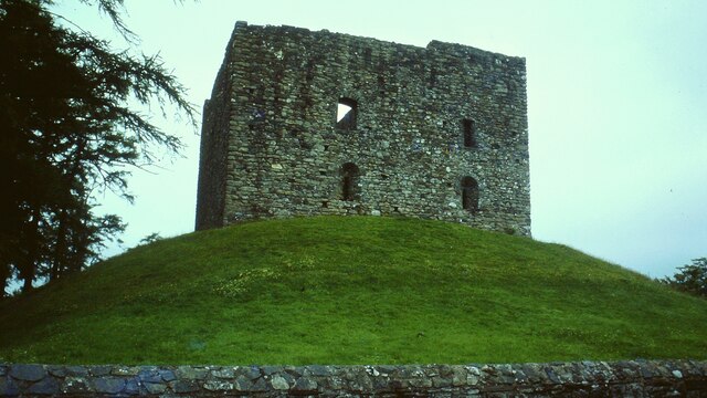
Lydford Castle

Lydford Castle is a medieval castle in the town of Lydford, Devon, England. The first castle in Lydford, sometimes termed the Norman fort, was a small...

Brat Tor

Brat Tor, also known as Brai Tor and Widgery Tor, is a dramatic granite tor on the western flank of Dartmoor, England. It is best known for Widgery Cross...

West Devon

West Devon is a local government district with borough status in Devon, England. Its council is based in Tavistock, the borough's largest town. The borough...

Burley Wood

Burley Wood is the site of an Iron Age hill fort north of Lydford in Devon, England. The fort occupies much of a hilltop some 220 metres above sea level...

Great Links Tor

Great Links Tor is a prominent tor on the north-western flank of Dartmoor, Devon, England. It is visible for a considerable distance on the approach to...

Bridestowe

Bridestowe () is a civil parish and village in the district of West Devon, Devon, England. The parish is surrounded clockwise from the north by the parishes...

Nearby Amenities

Located within 500m of 50.654696,-4.0962401
Vale Down
Place: hamlet
Source: OS_OpenData_StreetView
Lat/Long: 50.6559178/-4.0906301
Moor View House
Addr City: Okehampton
Addr Postcode: EX20 4BB
Addr Street: Vale Down
Addr Suburb: Vale Down
Tourism: guest_house
Lat/Long: 50.6553939/-4.0904023
Mine (dis)
Historic: archaeological_site
Lat/Long: 50.656475/-4.1020183
Ncn Milepost: mills
Sustrans Ref: MP781
Lat/Long: 50.6565034/-4.0960974
Post Box
Brand: Royal Mail
Brand Wikidata: Q638098
Brand Wikipedia: en:Royal Mail
Collection Times: Mo-Fr 09:00; Sa 07:00; Su off
Drive Through: no
Operator: Royal Mail
Operator Wikidata: Q638098
Post Box Design: type_c
Post Box Mounting: brick_pillar
Post Box Type: wall
Ref: EX20 154D
Royal Cypher: GR
Royal Cypher Wikidata: Q33102273
Source: survey;streetlevel imagery;aerial imagery
Lat/Long: 50.6553157/-4.0899305
The data included in this document is from www.openstreetmap.org. The data is made available under ODbL.

Have you been to Battishill Down?

Leave your review of Battishill Down below (or comments, questions and feedback).