Bad nan Cearc

Downs, Moorland in Perthshire

Scotland

Bad nan Cearc

The lower slopes of Stob Garbh-Leachtir
The lower slopes of Stob Garbh-Leachtir Credit: John Ferguson

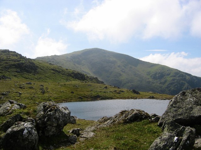
Bad nan Cearc, located in Perthshire, Scotland, is a picturesque area known for its expansive downs and moorland landscapes. Situated amidst the stunning Scottish Highlands, this region boasts breathtaking natural beauty and a rich history.

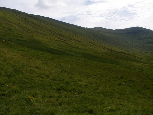
The downs of Bad nan Cearc offer vast open spaces adorned with heather, grasses, and wildflowers, creating a colorful and vibrant panorama. The undulating terrain provides ample opportunities for leisurely walks, horse riding, and wildlife observation. Visitors can enjoy the peacefulness and solitude of the downs, as well as the stunning views of the surrounding mountains.

The moorlands in Bad nan Cearc are characterized by their rugged beauty and diverse ecosystems. These areas are home to various species of birds, including golden eagles, red grouse, and peregrine falcons. Additionally, the moorlands support a variety of plant life, such as heather and sphagnum moss, creating a unique and enchanting environment.

Stepping into Bad nan Cearc is like taking a step back in time. The region is steeped in history, with ancient ruins and archaeological sites dotting the landscape. Visitors can explore the remnants of Iron Age settlements, standing stones, and burial sites, gaining insight into the lives of past inhabitants.

Overall, Bad nan Cearc in Perthshire offers visitors a chance to immerse themselves in the natural beauty of Scotland. With its downs and moorlands, rich wildlife, and historical significance, this region is a must-visit for nature lovers and history enthusiasts alike.

If you have any feedback on the listing, please let us know in the comments section below.

Bad nan Cearc Images

Images are sourced within 2km of 56.53747/-4.6016549 or Grid Reference NN4041. Thanks to Geograph Open Source API. All images are credited.

The lower slopes of Stob Garbh-Leachtir
Stock fence on the flank of Meallan Odhar Looking across Loch Lyon towards Meall Tionail.
Stock fence on the flank of Meallan Odhar
Looking across Loch Lyon towards Meall Tionail.
Hydro Road Hydro road on north shore of Loch Lyon. In the distance can be seen one of the many tracks hereabouts that are ignored on the latest Ordnance maps.
Hydro Road
Hydro road on north shore of Loch Lyon. In the distance can be seen one of the many tracks hereabouts that are ignored on the latest Ordnance maps.
Lochside Track This photo is looking west over Loch Lyon from the track on the south side of the loch. The hill on the right is Beinn Chreachain. On the left Beinn Mhanach. The distant notch in the centre of the skyline is the north face of Beinn An Dothaidh.
  Of note for anyone visiting this area is that despite not being shown on current maps there is now a track all the way round Loch Lyon. The track on the south side is excellent and suitable for cycling.
Lochside Track
This photo is looking west over Loch Lyon from the track on the south side of the loch. The hill on the right is Beinn Chreachain. On the left Beinn Mhanach. The distant notch in the centre of the skyline is the north face of Beinn An Dothaidh. Of note for anyone visiting this area is that despite not being shown on current maps there is now a track all the way round Loch Lyon. The track on the south side is excellent and suitable for cycling.
Southern reaches of Loch Lyon The rounded hill is Beinn nam Fhuaran (806m) with Beinn Dorain (1076m) beyond.
Southern reaches of Loch Lyon
The rounded hill is Beinn nam Fhuaran (806m) with Beinn Dorain (1076m) beyond.
The central stretch of Loch Lyon Across the water the Munro of Beinn a'Chreachain rises above Gleann Meurain and Gleann Cailliche.
The central stretch of Loch Lyon
Across the water the Munro of Beinn a'Chreachain rises above Gleann Meurain and Gleann Cailliche.
Loch Lyon looking west Three Munros dominate the skyline: Beinn Dorain, Beinn Mhanach and Beinn Achaladair.
Loch Lyon looking west
Three Munros dominate the skyline: Beinn Dorain, Beinn Mhanach and Beinn Achaladair.
Allt Sheasgarnaich
Allt Sheasgarnaich
Allt Sheasgarnaich
Allt Sheasgarnaich
Estate track above Loch Lyon
Gleann Meurain This gap in the hills south of Rannoch Moor was once suggested by Telford as a possible route for a road. Now part of it is flooded by the extended Loch Lyon, but not to the extent suggested by the Ordnance Survey. The well established road runs through to Auch or returns by the south side of Loch Lyon and is still not on any Ordnance Survey mapping.

The road has few bridges and will  be difficult or impossible in very wet weather.

The hill is Beinn a' Chreachain, 1085m/650m prominence.
Gleann Meurain
This gap in the hills south of Rannoch Moor was once suggested by Telford as a possible route for a road. Now part of it is flooded by the extended Loch Lyon, but not to the extent suggested by the Ordnance Survey. The well established road runs through to Auch or returns by the south side of Loch Lyon and is still not on any Ordnance Survey mapping. The road has few bridges and will be difficult or impossible in very wet weather. The hill is Beinn a' Chreachain, 1085m/650m prominence.
Bogs and Loch Lyon Looking towards the dam across the Meurain arm.  Out in the water is the approximate site of the outflow of the natural loch and the former end of the public road up Glen Lyon. Evidence from vegetation shows that the new loch is nowhere near as extensive as shown by the Ordnance Survey. 

Even though a reservoir now, this is still a beautiful place surrounded by snow topped hills and with numerous waterfalls.
Bogs and Loch Lyon
Looking towards the dam across the Meurain arm. Out in the water is the approximate site of the outflow of the natural loch and the former end of the public road up Glen Lyon. Evidence from vegetation shows that the new loch is nowhere near as extensive as shown by the Ordnance Survey. Even though a reservoir now, this is still a beautiful place surrounded by snow topped hills and with numerous waterfalls.
Sheepwalk, Glen Lyon Lime rich soils produce good grazing for sheep, but the best land was lost to the hydro electric reservoir. 
A burn enters the loch near the site of Invermearn, a drowned farm downstream of the outflow of the natural Loch Lyon.
Sheepwalk, Glen Lyon
Lime rich soils produce good grazing for sheep, but the best land was lost to the hydro electric reservoir. A burn enters the loch near the site of Invermearn, a drowned farm downstream of the outflow of the natural Loch Lyon.
Loch Lyon, Invermearn Good quality grazing has survived, but most of the best farmland has gone the way of Invermearn, beneath Loch Lyon.
Loch Lyon, Invermearn
Good quality grazing has survived, but most of the best farmland has gone the way of Invermearn, beneath Loch Lyon.
Invermearn Invermearn is now beneath the loch which was vastly enlarged for hydro electric generation. On the right is the Meurain arm, the flooded bit of Gleann Meurain, while Glen Lyon continues straight ahead. The narrow bit of the loch beyond the arm is the site of the natural loch.
Invermearn
Invermearn is now beneath the loch which was vastly enlarged for hydro electric generation. On the right is the Meurain arm, the flooded bit of Gleann Meurain, while Glen Lyon continues straight ahead. The narrow bit of the loch beyond the arm is the site of the natural loch.
Leacan Tarsainn Steep slopes of Meall Dail above Gleann Meurain.
Leacan Tarsainn
Steep slopes of Meall Dail above Gleann Meurain.
Road, Loch Lyon A road now runs right around the enlarged Loch Lyon.
Road, Loch Lyon
A road now runs right around the enlarged Loch Lyon.
Delivery, Loch Lyon A tractor delivering what were probably fencing materials. It had driven in from Auch. The view is across Loch Lyon at a point where there was a natural loch before the Hydro.
Delivery, Loch Lyon
A tractor delivering what were probably fencing materials. It had driven in from Auch. The view is across Loch Lyon at a point where there was a natural loch before the Hydro.
Show me another place!

Bad nan Cearc is located at Grid Ref: NN4041 (Lat: 56.53747, Lng: -4.6016549)

Unitary Authority: Perth and Kinross

Police Authority: Tayside

What 3 Words

///offline.embedded.crows. Near Pubil, Perth & Kinross

Nearby Locations

Bad nan Cearc

Related Wikis

Beinn Mhanach

Beinn Mhanach (Scottish Gaelic for 'monks' mountain'), also anglicized Ben Vannoch, is a mountain in the Breadalbane region of the Scottish Highlands....

Loch Lyon

Loch Lyon (Scottish Gaelic, Loch Lìobhann) is a freshwater loch in Glen Lyon, located in Perthshire, Scotland, which feeds the River Lyon, a tributary...

Beinn Heasgarnich

Beinn Heasgarnich (Scottish Gaelic: Beinn Sheasgarnaich) is a mountain in the Breadalbane region of the Scottish Highlands. It lies about 2 km south of...

Beinn a' Chreachain

Beinn a' Chreachain (lit. "Mountain of Scallops") is a Scottish mountain, with a conical top, to the north-west of Loch Lyon. == References == The Munros...

Meall Buidhe (Corbett)

Meall Buidhe is a Corbett situated in the southern highlands of Scotland. It forms part of the ridge line separating Glen Daimh, an offshoot of Glen Lyon...

Creag Mhòr

Creag Mhòr is a mountain in the Breadalbane region of the Scottish Highlands. It is in the Forest of Mamlorn, ten kilometres northeast of Tyndrum, and...

Beinn Achaladair

Beinn Achaladair is a Scottish mountain situated six kilometres north east of the hamlet of Bridge of Orchy. The mountain stands on the border of the...

Gorton railway station (Scotland)

Gorton railway station or Gortan railway station, named for the nearby Meall a Ghortain area of high ground, was a remote rural private railway station...

Nearby Amenities

Located within 500m of 56.53747,-4.6016549
Ford: yes
Lat/Long: 56.533616/-4.6035723
The data included in this document is from www.openstreetmap.org. The data is made available under ODbL.

Have you been to Bad nan Cearc?

Leave your review of Bad nan Cearc below (or comments, questions and feedback).