Berry Down

Downs, Moorland in Cornwall

England

Berry Down

On SW Coast Path - view W above Trethill Cliffs
On SW Coast Path - view W above Trethill Cliffs Credit: Colin Park

Berry Down is a picturesque region located in Cornwall, England. Situated on the outskirts of the town of Bideford, it encompasses a vast expanse of downs and moorland, offering visitors breathtaking views and a serene environment.

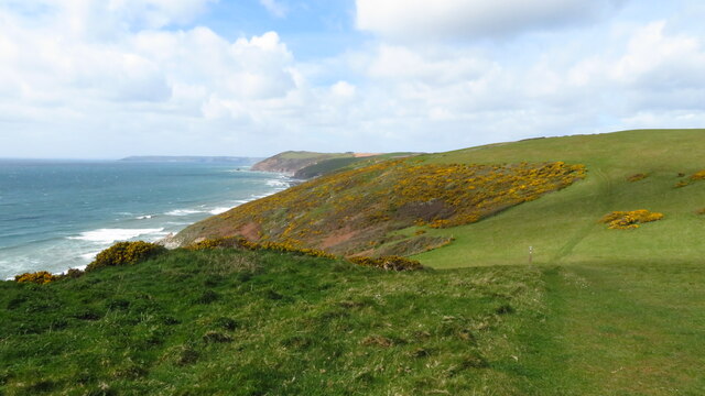
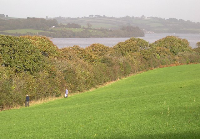
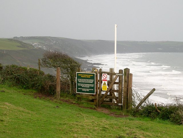
The downs of Berry Down are characterized by rolling hills covered in lush grasses and dotted with vibrant wildflowers during the spring and summer months. As visitors traverse the landscape, they can enjoy panoramic vistas of the surrounding countryside, including the nearby coastline and the Bristol Channel. The area is popular among nature enthusiasts and hikers, who can explore the numerous walking trails that crisscross the downs, providing access to hidden valleys and secluded spots.

The moorland of Berry Down adds further diversity to the region's natural beauty. Blanketed with heather and gorse, the moors create a stunning patchwork of colors, particularly during late summer. The moorland is also home to a variety of wildlife, including birds such as skylarks and stonechats, as well as small mammals like rabbits and foxes.

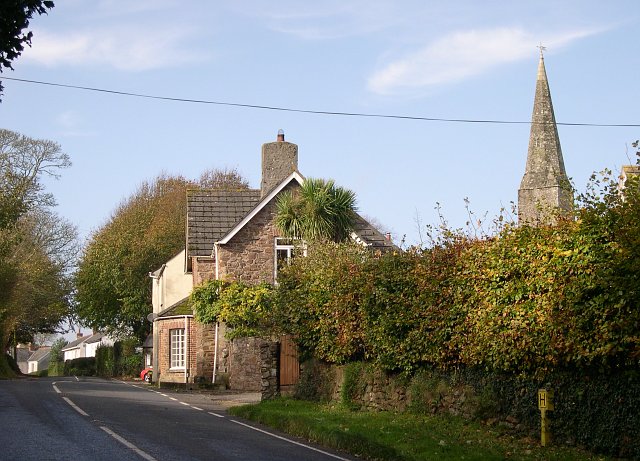
Aside from its natural wonders, Berry Down also holds historical significance. The remnants of ancient settlements can be found scattered across the downs, offering glimpses into the area's rich past. Additionally, the nearby village of Northam boasts several historic buildings and landmarks that attract history enthusiasts.

Overall, Berry Down in Cornwall is a captivating destination that seamlessly combines natural beauty, tranquility, and historical heritage. Whether exploring its downs, wandering through its moorland, or delving into its history, visitors are sure to be captivated by the charm and allure of this remarkable region.

If you have any feedback on the listing, please let us know in the comments section below.

Berry Down Images

Images are sourced within 2km of 50.374822/-4.2849701 or Grid Reference SX3755. Thanks to Geograph Open Source API. All images are credited.

On SW Coast Path - view W above Trethill Cliffs
Crafthole Village Crafthole is a village on the hilltop above Portwrinkle. The picture shows part of the old village centre although there are many more 20th century houses in the village.
Crafthole Village
Crafthole is a village on the hilltop above Portwrinkle. The picture shows part of the old village centre although there are many more 20th century houses in the village.
Old farm buildings at Tredrossel Conversions are taking place, the farthest building has been converted into cottages.
Old farm buildings at Tredrossel
Conversions are taking place, the farthest building has been converted into cottages.
Sheviock Looking east towards the village of Sheviock from Horsepool Road.  The freshwater lake in the foreground has been artificially created.
Sheviock
Looking east towards the village of Sheviock from Horsepool Road. The freshwater lake in the foreground has been artificially created.
Sheviock A view of the village from the eastern side.  The church spire on the right is the Parish Church of St Mary, Sheviock.  While this may look an idyllic scene, Sheviock is one of those unfortunate villages which is split by a fast main road.  Although some of the traffic actually obeys the 40mph speed limit, this does not really help to make it either peaceful or safe.
Sheviock
A view of the village from the eastern side. The church spire on the right is the Parish Church of St Mary, Sheviock. While this may look an idyllic scene, Sheviock is one of those unfortunate villages which is split by a fast main road. Although some of the traffic actually obeys the 40mph speed limit, this does not really help to make it either peaceful or safe.
The A374 east of Sheviock This stretch of road between the villages of Antony and Polbathic cuts through the low-lying mainly wooded countryside along the south side of Lynher River estuary.  Its open curves and good cambers make it a favourite with motor cyclists.
The A374 east of Sheviock
This stretch of road between the villages of Antony and Polbathic cuts through the low-lying mainly wooded countryside along the south side of Lynher River estuary. Its open curves and good cambers make it a favourite with motor cyclists.
Not the way into Wacker Woods While the footpath looks inviting, the sign warns that it leads into a military training area and that entry is forbidden.
Not the way into Wacker Woods
While the footpath looks inviting, the sign warns that it leads into a military training area and that entry is forbidden.
Wacker Quay and Warren Point Looking over the old quayside and across the entrance to the tidal creek called Wacker Lake to the woodlands at Warren Point.  Wacker Quay used to be where ammunition and other goods were brought in for the military fortifications of Scraesdon Fort and Tregantle Fort.  They were taken up to the forts on a railway line which started here but has long since disappeared.
Wacker Quay and Warren Point
Looking over the old quayside and across the entrance to the tidal creek called Wacker Lake to the woodlands at Warren Point. Wacker Quay used to be where ammunition and other goods were brought in for the military fortifications of Scraesdon Fort and Tregantle Fort. They were taken up to the forts on a railway line which started here but has long since disappeared.
A waterside field Note the two berry pickers at the field edge.
A waterside field
Note the two berry pickers at the field edge.
Golf Course near Crafthole Looking over part of a golf course between Crafthole and the sea cliffs.
Golf Course near Crafthole
Looking over part of a golf course between Crafthole and the sea cliffs.
Entrance to the path by Tregantle Fort This permissive path is one of the most recently opened sections of the South West Coast Path.  It is closed when the MOD firing ranges at Tregantle are being used, at which times walkers must take a detour to the landward side of the fort.
Entrance to the path by Tregantle Fort
This permissive path is one of the most recently opened sections of the South West Coast Path. It is closed when the MOD firing ranges at Tregantle are being used, at which times walkers must take a detour to the landward side of the fort.
World War II Pillbox This old pillbox sits decaying in the corner of a field.
World War II Pillbox
This old pillbox sits decaying in the corner of a field.
Entrance to Cornish Owl Centre There are a lot of interesting owls here.
Entrance to Cornish Owl Centre
There are a lot of interesting owls here.
Lynher River near Erth Barton One of the arms of the complex estuary which becomes Plymouth Sound. The Lynher (or St. Germans) River snakes inland for several miles forming numerous tidal creeks. This section varies dramatically between low and high tides.
Lynher River near Erth Barton
One of the arms of the complex estuary which becomes Plymouth Sound. The Lynher (or St. Germans) River snakes inland for several miles forming numerous tidal creeks. This section varies dramatically between low and high tides.
Tidal Marshes, Sconner Turf , St Germans Photograph taken in winter from high ground close to St Germans railway station south eastwards, down river from Polbathic lake.  Sconner Turf Wood is beyond the river. These are the higher reaches of the Lyner, a tidal drowned river valley.
Tidal Marshes, Sconner Turf , St Germans
Photograph taken in winter from high ground close to St Germans railway station south eastwards, down river from Polbathic lake. Sconner Turf Wood is beyond the river. These are the higher reaches of the Lyner, a tidal drowned river valley.
Fort Tregantle from the sea
Scraesdon Fort Used by Marines for Training - used blanks / trip flares all around
Scraesdon Fort
Used by Marines for Training - used blanks / trip flares all around
Aerial View of Scraesdon Fort and Antony This picture clearly shows the outline of Scraesdon Fort with its defensive moat filled with mature trees. The village of Antony is in the picture as is Scraesdon Farm and all roads contained within the 1km square map image.
Aerial View of Scraesdon Fort and Antony
This picture clearly shows the outline of Scraesdon Fort with its defensive moat filled with mature trees. The village of Antony is in the picture as is Scraesdon Farm and all roads contained within the 1km square map image.
Show me another place!

Berry Down is located at Grid Ref: SX3755 (Lat: 50.374822, Lng: -4.2849701)

Unitary Authority: Cornwall

Police Authority: Devon and Cornwall

What 3 Words

///coasters.huts.sweetly. Near Landrake, Cornwall

Related Wikis

Sheviock

Sheviock (Cornish: Seviek, meaning strawberry bed) is a coastal civil parish and a hamlet in south-east Cornwall, England, United Kingdom. The parish is...

Crafthole

Crafthole is a village in the parish of Sheviock, in southeast Cornwall, England, UK. The village has a pub (Finnygook Inn), Post Office, shop, Methodist...
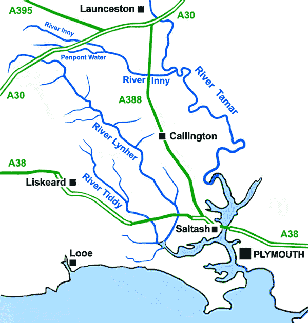
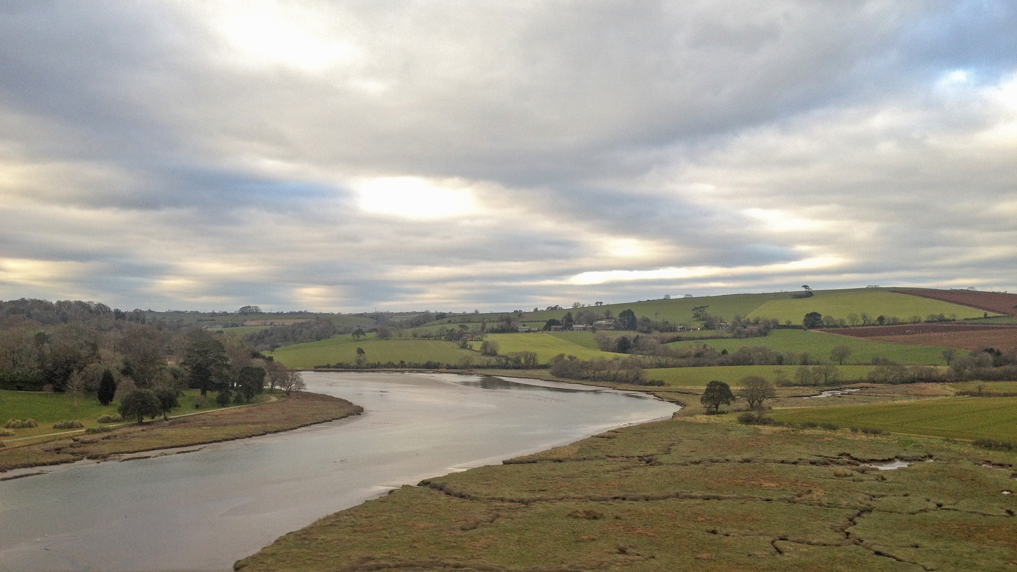
River Lynher

The River Lynher (Cornish: Linar) (or St Germans River downstream from its confluence with the Tiddy) flows through east Cornwall, England, and enters...

River Tiddy

The River Tiddy (Cornish: Teudhi) is a small river in south-east Cornwall, the main tributary of the River Lynher. The Tiddy rises near Pensilva and flows...
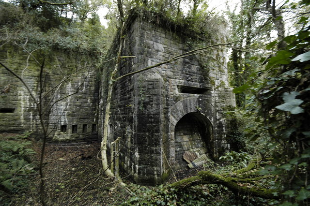
Scraesdon Fort

Scraesdon Fort, near the village of Antony, is one of several forts in South East Cornwall which formed part of the ring of forts surrounding Plymouth...
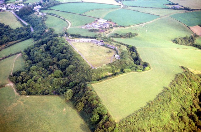
Tregantle Fort

Tregantle Fort in south east Cornwall is one of several forts surrounding Plymouth that were built as a result of a decision in Lord Palmerston's premiership...

Lower Tregantle

Lower Tregantle is a hamlet in Cornwall, England, UK. It is about half a mile south of Antony; Higher Tregantle is about a quarter of a mile further south...

Church of St James, Antony

The Church of St James is a Grade I listed 12th-century Anglican parish church in Antony, Cornwall, England. == History == The church is located in Antony...

Nearby Amenities

Located within 500m of 50.374822,-4.2849701
Created By: almien_coastlines
Source: PGS
Lat/Long: 50.375047/-4.278111
Created By: almien_coastlines
Source: PGS
Lat/Long: 50.375555/-4.278525
Created By: almien_coastlines
Source: PGS
Lat/Long: 50.375807/-4.278933
Created By: almien_coastlines
Source: PGS
Lat/Long: 50.376571/-4.279354
Source: PGS
Lat/Long: 50.3772295/-4.2794926
Source: PGS
Lat/Long: 50.3776954/-4.2798992
Created By: almien_coastlines
Source: PGS
Lat/Long: 50.377841/-4.28039
Source: PGS
Lat/Long: 50.3783953/-4.281501
Source: PGS
Lat/Long: 50.3788045/-4.2824044
Power: pole
Lat/Long: 50.373722/-4.2788529
Power: pole
Lat/Long: 50.3743737/-4.2795825
Power: pole
Lat/Long: 50.3751247/-4.2804649
Power: pole
Lat/Long: 50.3759047/-4.2813742
Power: pole
Lat/Long: 50.3767121/-4.2822996
Power: pole
Lat/Long: 50.377386/-4.2830801
Power: pole
Lat/Long: 50.3778701/-4.2822808
Generator Method: photovoltaic
Generator Output Electricity: yes
Generator Source: solar
Generator Type: solar_photovoltaic_panel
Location: roof
Power: generator
Lat/Long: 50.3734341/-4.2909468
The data included in this document is from www.openstreetmap.org. The data is made available under ODbL.

Have you been to Berry Down?

Leave your review of Berry Down below (or comments, questions and feedback).