Burnhead Moor
Downs, Moorland in Renfrewshire
Scotland
Burnhead Moor
Burnhead Moor is a vast expanse of moorland located in Renfrewshire, Scotland. Covering an area of approximately 1,000 acres, it is situated near the village of Howwood, about 12 miles southwest of Glasgow. The moorland is characterized by its undulating terrain, featuring gently sloping hills and valleys.
The landscape of Burnhead Moor is predominantly covered in heather, which creates a beautiful purple hue during the summer months. This vegetation provides a habitat for various species of birds, including skylarks, meadow pipits, and curlews. The moorland is also home to a variety of insects and small mammals.
Visitors to Burnhead Moor can enjoy the tranquility and open space the area offers. It is a popular destination for walkers, nature enthusiasts, and birdwatchers. Several walking trails crisscross the moorland, allowing visitors to explore its diverse habitats and take in the stunning views of the surrounding countryside.
Due to its remote location and limited light pollution, Burnhead Moor is an excellent spot for stargazing. On clear nights, the dark skies provide an opportunity to observe constellations, planets, and even the occasional meteor shower.
However, it is important to note that Burnhead Moor is a protected area, managed by the Scottish Wildlife Trust. Visitors are urged to respect the fragile ecosystem and adhere to any guidelines or restrictions in place to preserve the natural beauty of the moorland.
If you have any feedback on the listing, please let us know in the comments section below.
Burnhead Moor Images
Images are sourced within 2km of 55.925232/-4.7457642 or Grid Reference NS2873. Thanks to Geograph Open Source API. All images are credited.

![Remains of enclosures See <a href="https://www.geograph.org.uk/photo/1853572">NS2973 : Lurg Moor Roman fortlet</a> for a discussion of various other antiquities located nearby on the moor, with links to photographs. Compared to some of those sites, the remains shown in the present photograph are less conspicuous, but they are shown on the 1:25000 OS map.
Several enclosures have been reported in the immediate vicinity of this one, but the remains shown in this photograph are the easiest to pick out visually. See <span class="nowrap"><a title="https://canmore.org.uk/site/41340/burnhead-moor" rel="nofollow ugc noopener" href="https://canmore.org.uk/site/41340/burnhead-moor">Link</a><img style="margin-left:2px;" alt="External link" title="External link - shift click to open in new window" src="https://s1.geograph.org.uk/img/external.png" width="10" height="10"/></span> (at Canmore) for further details; the subject of this photograph is structure &quot;A&quot; in that report, the D-shaped enclosure. Structures &quot;A&quot; and &quot;B&quot; together make up the enclosures that are depicted on the 1:25000 map.
[See <span class="nowrap"><a title="https://www.google.com/maps/d/viewer?mid=1Np6emNB53CxbNJmyJ_LicpxJvus&amp;ll=55.915499%2C-4.72162400000002&amp;z=19" rel="nofollow ugc noopener" href="https://www.google.com/maps/d/viewer?mid=1Np6emNB53CxbNJmyJ_LicpxJvus&amp;ll=55.915499%2C-4.72162400000002&amp;z=19">Link</a><img style="margin-left:2px;" alt="External link" title="External link - shift click to open in new window" src="https://s1.geograph.org.uk/img/external.png" width="10" height="10"/></span> for an annotated satellite image (zoom out for other antiquities located nearby). The satellite view shows some other interesting details nearby: for example, only 60 metres ESE is another feature, the form of two overlapping circles: I examined that area on a later visit: <a href="https://www.geograph.org.uk/photo/2089851">NS3072 : Possible hut circles on Burnhead Moor</a>.]
The present photograph shows two ridges, both greener than the surrounding moor, but with some dark tussocks along their course. The nearer one is straight, and the more distant one is curved into a C-shape, with the open side toward the photographer, so that they are arranged (very roughly) as &quot;C|&quot;.
In the foreground, just below the centre of the photograph, part of the nearer (straight) ridge runs across the width of the image, sloping upwards to the right. Behind it is the other (curved) ridge. Only one half of its C-shape is seen in this view; the near end of that arm of the ridge is to the left of and slightly above the centre of the photograph. From there, the ridge can be followed to the right-hand edge of the picture.
Providing confirmation of the view direction, Corlic Hill (called Corlick Hill on the OS map) appears centrally on the skyline.](https://s3.geograph.org.uk/geophotos/01/85/55/1855511_63674562.jpg)


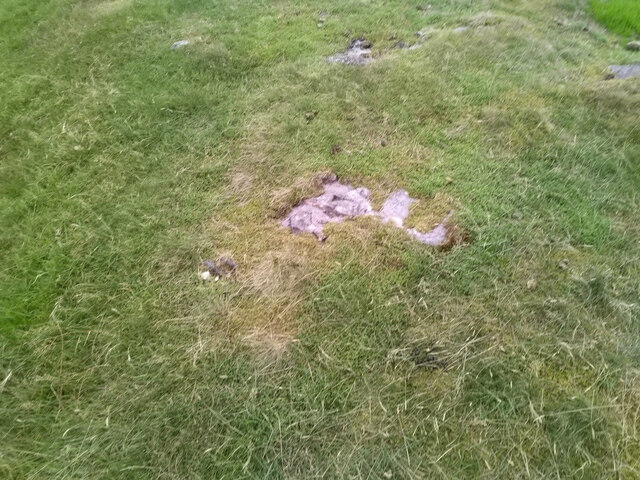
![Possible hut circles on Burnhead Moor [Update: on the nature of what is shown here, the following comments refer to a field visit made by professional archaeologists in 2012: &quot;It is possible that both features ... are the remains of hut platforms, but they are equally likely to be the result of geology and natural vegetation cover&quot;. One of the main reasons for my submitting possible finds is so that they can be properly assessed, and I am glad that this has occurred.]
A number of hut circles and ancient enclosures have already been reported from these moors. The majority of these discoveries were made by the Renfrewshire archaeologist Frank Newall.
Three such sites are known from the immediate vicinity of the area shown in this photograph; for those reports, see (1) <span class="nowrap"><a title="https://canmore.org.uk/site/41340/burnhead-moor" rel="nofollow ugc noopener" href="https://canmore.org.uk/site/41340/burnhead-moor">Link</a><img style="margin-left:2px;" alt="External link" title="External link - shift click to open in new window" src="https://s1.geograph.org.uk/img/external.png" width="10" height="10"/></span> (2) <span class="nowrap"><a title="https://canmore.org.uk/site/41375/burnhead-moor" rel="nofollow ugc noopener" href="https://canmore.org.uk/site/41375/burnhead-moor">Link</a><img style="margin-left:2px;" alt="External link" title="External link - shift click to open in new window" src="https://s1.geograph.org.uk/img/external.png" width="10" height="10"/></span> (3) <span class="nowrap"><a title="https://canmore.org.uk/site/42449/burnhead-moor-hut-circle" rel="nofollow ugc noopener" href="https://canmore.org.uk/site/42449/burnhead-moor-hut-circle">Link</a><img style="margin-left:2px;" alt="External link" title="External link - shift click to open in new window" src="https://s1.geograph.org.uk/img/external.png" width="10" height="10"/></span> (all at Canmore). The first of those reports corresponds to <a href="https://www.geograph.org.uk/photo/1855511">NS3072 : Remains of enclosures</a>; the other two are about sites just to the north and west of those enclosures.
However, the rather faint feature that is shown in this photograph lies about 65 metres to the east of the enclosures; it seems, therefore, that this particular site had not been reported until now. It is noticeable on some satellite imagery (although to what extent very much depends on when those images were taken); see the link in the end-note for a satellite view centred on this feature.
The NW circle of the pair is shown here at the centre of the photograph, and it fills most of the width of the image. For a view from a different angle, see <a href="https://www.geograph.org.uk/photo/2089865">NS3072 : Possible hut circles on Burnhead Moor</a>. The area is flat, and falls away at its northern rocky edge. In both photographs, traces of a low circular ridge can be seen on the elevated upper surface (most notably at the link just cited).
These circular features might be hut circles (the conventional name given to the remains of roundhouses – circular dwellings of various kinds – dating from the late Bronze Age or early Iron Age); if this interpretation is correct, then the overlapping circles indicate that a later building was erected on almost the same spot as an earlier one (a good location was likely to be re-used). As mentioned above, several rather more visible hut circles have already been recorded from other parts of the moor (see <a href="https://www.geograph.org.uk/photo/1853572">NS2973 : Lurg Moor Roman fortlet</a> for the relevant links).
The area shown in the present photograph is flat, and is slightly elevated above the surrounding moorland; it would have provided an ideal platform for a dwelling. However, the traces visible on the ground here are slight, and it would take a more expert appraisal than mine to definitely identify them as genuine hut circles. Nevertheless, the feature shown in the present photograph may merit further examination; to that end, I have submitted a report to WoSAS (that report also includes the feature described below).
Similar circular features can be seen nearby; one of them is located just 55 metres to the east: <a href="https://www.geograph.org.uk/photo/2089891">NS3072 : Possible hut circle on Burnhead Moor</a>.](https://s3.geograph.org.uk/geophotos/02/08/98/2089851_3b668788.jpg)
![Possible hut circles on Burnhead Moor [Update: on the nature of what is shown here, the following comments refer to a field visit made by professional archaeologists in 2012: &quot;It is possible that both features ... are the remains of hut platforms, but they are equally likely to be the result of geology and natural vegetation cover&quot;. One of the main reasons for my submitting possible finds is so that they can be properly assessed, and I am glad that this has occurred.]
See <a href="https://www.geograph.org.uk/photo/2089851">NS3072 : Possible hut circles on Burnhead Moor</a> for the main description. The present photograph is likewise a view over the north-western circle of the pair, but looking to the NE.
Compare a known <a href="https://www.geograph.org.uk/photo/1855199">NS2973 : Hut circle on Lurg Moor</a>, which is located about 1.3 km to the NNW, and which presents a rather similar appearance; the slightly-elevated area shown in the present photograph is likewise very flat on top. Note also, in the present view, what appears to be a low ridge, extending from the near side of the rocky area on the left, and following a curving course along the near edge of the flat elevated area.
Harelaw Reservoir can be seen in the background, although it is more apparent in the larger versions of the image.](https://s1.geograph.org.uk/geophotos/02/08/98/2089865_bdfd4472.jpg)
![Possible hut circle on Burnhead Moor [Update: on the nature of what is shown here, the following comments refer to a field visit made by professional archaeologists in 2012: &quot;It is possible that both features ... are the remains of hut platforms, but they are equally likely to be the result of geology and natural vegetation cover&quot;. One of the main reasons for my submitting possible finds is so that they can be properly assessed, and I am glad that this has occurred.]
This feature is located about 55 metres to the east of <a href="https://www.geograph.org.uk/photo/2089851">NS3072 : Possible hut circles on Burnhead Moor</a>; the view direction of both photographs is the same.
The circular outline fills most of the width of the image, and can be followed as a line of tussocks (the left-hand side is more apparent than the right). The feature is about 15 metres across, and could be the remains of a hut circle that had gone unrecorded until now; see the link in the previous paragraph for further details. Traces of ancient enclosures had already been recorded from close to this spot, and several hut circles are present elsewhere on the moor (see the 1:25000 map for <a href="https://www.geograph.org.uk/gridref/NS2973">NS2973</a>, and see <a href="https://www.geograph.org.uk/photo/1853572">NS2973 : Lurg Moor Roman fortlet</a> for links to the various antiquities located in this area).
See <span class="nowrap"><a title="https://www.google.com/maps/d/viewer?mid=1Np6emNB53CxbNJmyJ_LicpxJvus&amp;ll=55.915215999999994%2C-4.7198399999999765&amp;z=19" rel="nofollow ugc noopener" href="https://www.google.com/maps/d/viewer?mid=1Np6emNB53CxbNJmyJ_LicpxJvus&amp;ll=55.915215999999994%2C-4.7198399999999765&amp;z=19">Link</a><img style="margin-left:2px;" alt="External link" title="External link - shift click to open in new window" src="https://s1.geograph.org.uk/img/external.png" width="10" height="10"/></span> for a satellite view centred on this feature, which is indicated by a marker. On that view, there are hints of several similar features nearby, but they are considerably fainter and more indistinct.
[I have submitted a report to WoSAS, describing this circular feature and the one that is located 55 metres to the west (on which, see the link in the second paragraph).]](https://s3.geograph.org.uk/geophotos/02/08/98/2089891_9f90a19a.jpg)
![The ruins of Lurg Farm Of the three ruined farm buildings that I visited on the day, Lurg was the least well preserved.
[The other two are <a href="https://www.geograph.org.uk/photo/2503919">NS3074 : The ruins of Knocknairshill Farm</a>, 400m to the east, and <a href="https://www.geograph.org.uk/photo/2503964">NS2874 : The ruins of Loudenward Farm</a>, 1.3 km to the WSW.]
Lurg is shown and named from the first edition OS map (surveyed in 1857) onwards. The farm building was about 30 metres long, and fairly narrow, with its long axis oriented SW-NE. From the 1960s on, OS maps no longer name the ruins, which must already have been in poor condition. They are not depicted at all on present-day mapping (which is understandable, given that they are now fairly inconspicuous).
The photograph is a view of the south-eastern side (one of the long walls). The lower area on the right is outside the building, and the raised area on the left is the interior. The ground drops away quite sharply at the edge of that area, revealing the line of the wall, although there is now little exposed stone to be seen.
Trees now cover much of the area of the ruin, making it more difficult to reveal its form in photographs. Isolated fragments of wall, with some exposed stone, are located among the trees.
The farm appears to correspond to one that is shown, but not named, on Roy&#039;s Military Survey of Scotland (1740s-50s); see <a href="https://www.geograph.org.uk/photo/2088129">NS3074 : The ruins of Knocknairshill Farm</a>.
Although Lurg Farm is gone, the name survives in Lurg Moor (<a href="https://www.geograph.org.uk/gridref/NS2973">NS2973</a>) on the high ground to the south; also, just as Knocknairshill Farm was not far to the east of Lurg Farm, there is a Knocknairs Moor (<a href="https://www.geograph.org.uk/gridref/NS3073">NS3073</a>) just to the east of Lurg Moor.](https://s1.geograph.org.uk/geophotos/02/50/38/2503869_e72d8b4c.jpg)


Burnhead Moor is located at Grid Ref: NS2873 (Lat: 55.925232, Lng: -4.7457642)
Unitary Authority: Inverclyde
Police Authority: Renfrewshire and Inverclyde
What 3 Words
///grant.tree.ruled. Near Greenock, Inverclyde
Nearby Locations
Related Wikis

Easter Greenock Castle
Easter Greenock Castle was a castle of unknown design near the burgh of Greenock, Scotland. == History == === Construction and location === Built sometime...

Whinhill railway station
Whinhill railway station is a railway station located in the east of the town of Greenock, Inverclyde, Scotland. The station is managed by ScotRail and...
Upper Greenock railway station
Upper Greenock railway station was a railway station serving the town of Greenock, Inverclyde, Scotland, originally as part of the Greenock and Wemyss...
Cartsdyke
Cartsdyke (Scots: Cairstdyke, Scottish Gaelic: Gàradh Cairte), formerly known as Crawfurdsdyke, is a suburb of the town of Greenock, Scotland.Crawfurdsdyke...

Lynedoch railway station
Greenock Lynedoch was a railway station serving Greenock, Inverclyde, Scotland, originally as part of the Greenock and Ayrshire Railway. == History... ==

Gryffe Reservoirs
The Gryffe Reservoirs, also spelled 'Gryfe', take their name from the River Gryffe, name deriving from the Gaelic garbh meaning "rough stream". are two...

Cartsdyke railway station
Cartsdyke railway station serves part of the town of Greenock, Scotland. The station is on the Inverclyde Line, 22 miles (35 km) west of Glasgow Central...

Cappielow
Cappielow, also known as Cappielow Park supported by Dalrada Technology UK for sponsorship reasons, is a football stadium in Greenock, Inverclyde, Scotland...
Nearby Amenities
Located within 500m of 55.925232,-4.7457642Have you been to Burnhead Moor?
Leave your review of Burnhead Moor below (or comments, questions and feedback).