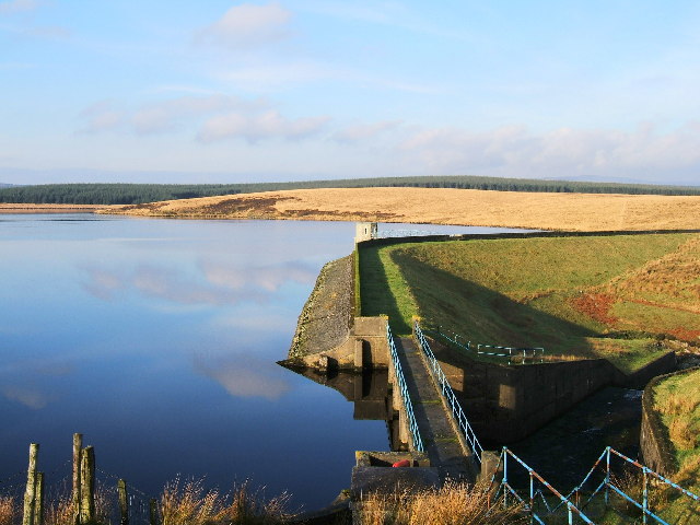
Bowdy House Brae

Downs, Moorland in Wigtownshire

Scotland

Bowdy House Brae

Old milestone New Luce 4 milestone hiding among the gorse nearly opposite a Passing Place.   Shortly, the road reaches the railway line and crosses the bridge over the Cross Water of Luce.   Barrhill is 10 miles to the north.
Old milestone Credit: Chris Minto

Bowdy House Brae is a picturesque area located in Wigtownshire, Scotland. Nestled amidst rolling hills and vast moorlands, it offers a captivating experience for nature enthusiasts and outdoor adventurers alike. The landscape is characterized by its dramatic downs and moorlands, creating a breathtaking panorama that stretches as far as the eye can see.

The area is known for its diverse flora and fauna, showcasing a rich tapestry of colors throughout the seasons. During the warmer months, the downs come alive with vibrant wildflowers, including heather, foxgloves, and bluebells, creating a stunning carpet of colors. The moorlands, on the other hand, provide a haven for various bird species, including curlews, lapwings, and skylarks, making it a paradise for birdwatchers.

Hikers and nature lovers will find plenty of opportunities to explore the area, with numerous trails and pathways meandering through the downs and moorlands. These trails offer breathtaking views and allow visitors to immerse themselves in the tranquility of the surrounding nature. It is worth mentioning that the terrain can be rugged and challenging in certain areas, so it is advisable to come prepared with appropriate footwear and clothing.

Bowdy House Brae is also steeped in history, with remnants of ancient settlements and burial sites scattered throughout the landscape. Archaeology enthusiasts can marvel at the stone circles and cairns, which provide a glimpse into the region's rich past.

Overall, Bowdy House Brae in Wigtownshire is a captivating destination, offering a harmonious blend of natural beauty, wildlife, and historical significance. Whether you are seeking solitude, adventure, or a deeper connection with nature, this area promises to leave a lasting impression.

If you have any feedback on the listing, please let us know in the comments section below.

Bowdy House Brae Images

Images are sourced within 2km of 54.995209/-4.8529286 or Grid Reference NX1770. Thanks to Geograph Open Source API. All images are credited.

Old milestone New Luce 4 milestone hiding among the gorse nearly opposite a Passing Place.   Shortly, the road reaches the railway line and crosses the bridge over the Cross Water of Luce.   Barrhill is 10 miles to the north.
Old milestone
New Luce 4 milestone hiding among the gorse nearly opposite a Passing Place. Shortly, the road reaches the railway line and crosses the bridge over the Cross Water of Luce. Barrhill is 10 miles to the north.
Road sign The traditional style of Passing Place sign which is almost opposite milestone New Luce 4.
Road sign
The traditional style of Passing Place sign which is almost opposite milestone New Luce 4.
Old milestone Behind the milestone, the Cross Water of Luce which eventually drains into Luce Bay.   This was the most northerly milestone spotted on this road although it is still about 4 miles to the border with Ayrshire.
Old milestone
Behind the milestone, the Cross Water of Luce which eventually drains into Luce Bay. This was the most northerly milestone spotted on this road although it is still about 4 miles to the border with Ayrshire.
Old milestone Gorse cleared away, milestone set upright.   A big improvement since April when it was almost hidden in the gorse bush.  The Cross Water of Luce is just visible in this photo.
Old milestone
Gorse cleared away, milestone set upright. A big improvement since April when it was almost hidden in the gorse bush. The Cross Water of Luce is just visible in this photo.
Old milestone This style of milestone was set up all over Wigtownshire at the end of the 19C.  This one has been slightly damaged at some time but the white paint will now make it more visible to passing vehicles.
Old milestone
This style of milestone was set up all over Wigtownshire at the end of the 19C. This one has been slightly damaged at some time but the white paint will now make it more visible to passing vehicles.
Old milestone Although it is still over 3 miles to the Wigtownshire border with Ayrshire, this is the most northerly milestone found so far.   Grass cleared and more white paint applied show this milestone just south of Tryock bridge to good advantage.
Old milestone
Although it is still over 3 miles to the Wigtownshire border with Ayrshire, this is the most northerly milestone found so far. Grass cleared and more white paint applied show this milestone just south of Tryock bridge to good advantage.
Old milestone The Barrhill face of the most northerly milestone found on this lovely route which often shares its views with the railway line to Stranraer.  Tryock bridge is just round the bend.
Old milestone
The Barrhill face of the most northerly milestone found on this lovely route which often shares its views with the railway line to Stranraer. Tryock bridge is just round the bend.
Dirniemow Bridge, north of New Luce The bridge carries the minor road (which makes a quarter turn at this point) from Barrhill to Glenluce across the Cross Water of Luce, a tributary of the Water of Luce. Built c.1813 and rebuilt in 1984, the bridge is a Category C Listed Building. <span class="nowrap"><a title="https://www.britishlistedbuildings.co.uk/200353701-dirniemow-bridge-new-luce#.WXH-LTGWw5s" rel="nofollow ugc noopener" href="https://www.britishlistedbuildings.co.uk/200353701-dirniemow-bridge-new-luce#.WXH-LTGWw5s">Link</a><img style="margin-left:2px;" alt="External link" title="External link - shift click to open in new window" src="https://s1.geograph.org.uk/img/external.png" width="10" height="10"/></span>
Dirniemow Bridge, north of New Luce
The bridge carries the minor road (which makes a quarter turn at this point) from Barrhill to Glenluce across the Cross Water of Luce, a tributary of the Water of Luce. Built c.1813 and rebuilt in 1984, the bridge is a Category C Listed Building. LinkExternal link
The Dirniemow Bridge On the road to Barrhill.
The Dirniemow Bridge
On the road to Barrhill.
The Road to New Luce
Cross Water of Luce
Cross Water of Luce
Cross Water of Luce
Cross Water of Luce
The Road to Barrhill
The Road to Glenwhilly Signal Box
The Dirniemow Bridge
Glenwhilly Signal Box
Ford, Cross Water of Luce
Show me another place!

Bowdy House Brae is located at Grid Ref: NX1770 (Lat: 54.995209, Lng: -4.8529286)

Unitary Authority: Dumfries and Galloway

Police Authority: Dumfries and Galloway

What 3 Words

///campfires.publisher.barefoot. Near Cairnryan, Dumfries & Galloway

Nearby Locations

Bowdy House Brae

Related Wikis

Glenwhilly railway station

Glenwhilly railway station served the area of Glenwhilly, Dumfries and Galloway, Scotland from 1887 to 1965 on the Girvan and Portpatrick Junction Railway...

Loups of Dalnigap

Loups of Dalnigap is a waterfall of Scotland. It sits below Dalnigap House, in the South of the Lagafater Estate. == See also == Waterfalls of Scotland...

Penwhirn Reservoir

Penwhirn Reservoir, is a reservoir in Dumfries and Galloway, Scotland, approximately 3.5 miles (6 km) east of Cairnryan. The reservoir was built in the...

New Luce

New Luce (Scottish Gaelic: Baile Ùr Ghlinn Lus) is a civil parish in Dumfries and Galloway, south-west Scotland. It lies in the traditional county of Wigtownshire...

Nearby Amenities

Located within 500m of 54.995209,-4.8529286
Power: pole
Lat/Long: 54.997976/-4.8579038
Power: pole
Lat/Long: 54.9970169/-4.8579038
Power: pole
Lat/Long: 54.9964381/-4.8579226
Power: pole
Lat/Long: 54.9957501/-4.8579438
Power: pole
Lat/Long: 54.9950432/-4.8579391
Power: pole
Lat/Long: 54.994509/-4.8579626
Power: pole
Lat/Long: 54.9936429/-4.8579109
Power: pole
Lat/Long: 54.9927714/-4.8578991
Power: pole
Lat/Long: 54.9922965/-4.8569043
Power: pole
Lat/Long: 54.9918202/-4.8559166
Power: pole
Lat/Long: 54.99129/-4.8548325
Power: pole
Lat/Long: 54.9910418/-4.8543057
The data included in this document is from www.openstreetmap.org. The data is made available under ODbL.

Have you been to Bowdy House Brae?

Leave your review of Bowdy House Brae below (or comments, questions and feedback).