East Glenquoich Forest

Downs, Moorland in Inverness-shire

Scotland

East Glenquoich Forest

Bridge over Allt a' Ghobhainn Known as Gow Bridge, between Poulary and Kingie on road to Kinloch Hourn.
Bridge over Allt a' Ghobhainn Credit: George Cross

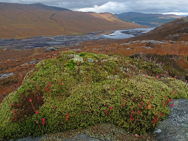
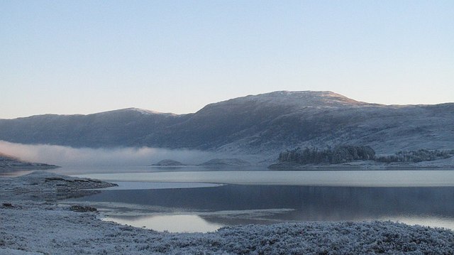
East Glenquoich Forest is a picturesque woodland located in Inverness-shire, Scotland. Situated in the southeastern part of the region, it covers a vast area of downs and moorland, providing a diverse and enchanting landscape for visitors to explore.

The forest is known for its abundance of native trees, including oak, birch, and pine, which create a dense canopy overhead, casting dappled shadows on the forest floor. This creates a perfect habitat for a variety of wildlife, such as red deer, squirrels, and a wide array of bird species.

Traversing through the forest, visitors can enjoy a network of well-marked trails that cater to different levels of fitness and interests. These trails offer magnificent views of the surrounding hills and valleys, providing a tranquil and peaceful experience for nature lovers and hikers alike.

East Glenquoich Forest also boasts a rich cultural heritage. There are remnants of ancient settlements and historical sites scattered throughout the forest, providing glimpses into the area's past. Visitors can stumble upon old stone circles, burial mounds, and even the ruins of a castle, adding an element of intrigue and fascination to their exploration.

For those seeking a more immersive experience, there are camping facilities available, allowing visitors to spend the night under the starry sky, surrounded by the soothing sounds of nature.

Overall, East Glenquoich Forest is a hidden gem in Inverness-shire, offering a harmonious blend of natural beauty, wildlife, and historical significance. It is a must-visit destination for anyone looking to escape the hustle and bustle of modern life and immerse themselves in the tranquility of the Scottish countryside.

If you have any feedback on the listing, please let us know in the comments section below.

East Glenquoich Forest Images

Images are sourced within 2km of 57.084796/-5.1210646 or Grid Reference NH1003. Thanks to Geograph Open Source API. All images are credited.

Bridge over Allt a' Ghobhainn Known as Gow Bridge, between Poulary and Kingie on road to Kinloch Hourn.
Bridge over Allt a' Ghobhainn
Known as Gow Bridge, between Poulary and Kingie on road to Kinloch Hourn.
New electric poles for 'Quoich T' Ongoing work, making ready for new pylon line to Skye, at 'Quoich T'.
New electric poles for 'Quoich T'
Ongoing work, making ready for new pylon line to Skye, at 'Quoich T'.
Signed path to Cluanie or Glen Shiel
The road from Kinloch Hourn In Glen Garry.
The road from Kinloch Hourn
In Glen Garry.
Birch tree beside the road in Glen Garry The road to Kinloch Hourn.
Birch tree beside the road in Glen Garry
The road to Kinloch Hourn.
Birch trees beside the road in Glen Garry The road from Kinloch Hourn. Loch Poulary can be glimpsed through the trees,
Birch trees beside the road in Glen Garry
The road from Kinloch Hourn. Loch Poulary can be glimpsed through the trees,
Pylon and substation in Glen Garry The landscape in Glen Garry is dominated by power lines running from the Quoich Power Station.
Pylon and substation in Glen Garry
The landscape in Glen Garry is dominated by power lines running from the Quoich Power Station.
Glen Garry - Footpath to Shiel Bridge and Cluanie Looking north-westward. The sign indicates that it is 20 miles to Shiel Bridge and 9 miles to Cluanie.
Glen Garry - Footpath to Shiel Bridge and Cluanie
Looking north-westward. The sign indicates that it is 20 miles to Shiel Bridge and 9 miles to Cluanie.
Ordnance Survey Cut Mark The mark is on top of the parapet of the road bridge that crosses the All a' Ghobhainn. Originally there would also have been a rivet but this has now gone.
This benchmark has a recorded height of 139.260 metres above sea level.
For more detail see : <span class="nowrap"><a title="https://www.bench-marks.org.uk/bm138369" rel="nofollow ugc noopener" href="https://www.bench-marks.org.uk/bm138369">Link</a><img style="margin-left:2px;" alt="External link" title="External link - shift click to open in new window" src="https://s1.geograph.org.uk/img/external.png" width="10" height="10"/></span>
Ordnance Survey Cut Mark
The mark is on top of the parapet of the road bridge that crosses the All a' Ghobhainn. Originally there would also have been a rivet but this has now gone. This benchmark has a recorded height of 139.260 metres above sea level. For more detail see : LinkExternal link
Lochan near Druim na h-Achlaise
New forestry plantation below Creag Poll-airigh
Moss covered rock, East Glenquoich Forest, Inverness-shire Looking towards Loch Loyne and Beinn Loinne (top left).

Taken during the annual autumn reduction of Loch Loyne's water level by the Hydro.  The course of the River Loyne, which can be seen on the left of the photo, would normally be submerged under the loch.
Moss covered rock, East Glenquoich Forest, Inverness-shire
Looking towards Loch Loyne and Beinn Loinne (top left). Taken during the annual autumn reduction of Loch Loyne's water level by the Hydro. The course of the River Loyne, which can be seen on the left of the photo, would normally be submerged under the loch.
Rocks, East Glenquoich Forest, Inverness-shire Looking across Glen Loyne towards Creag a' Mhàim.
Rocks, East Glenquoich Forest, Inverness-shire
Looking across Glen Loyne towards Creag a' Mhàim.
Rock, East Glenquoich Forest, Inverness-shire Looking across Glen Loyne towards Creag a' Mhàim.
Rock, East Glenquoich Forest, Inverness-shire
Looking across Glen Loyne towards Creag a' Mhàim.
Dead silver birch tree, East Glenquoich Forest, Inverness-shire Looking across Loch Loyne towards Beinn Loinne. <a href="https://www.geograph.org.uk/photo/1322503">NH1305 : Glenloyne</a> can just be seen at the bottom of the hillside opposite (to the right of the centre of the photo).
Dead silver birch tree, East Glenquoich Forest, Inverness-shire
Looking across Loch Loyne towards Beinn Loinne. NH1305 : Glenloyne can just be seen at the bottom of the hillside opposite (to the right of the centre of the photo).
Rowan tree, Glen Loyne, Inverness-shire Looking west along the glen towards Sgùrr Thionail.
Rowan tree, Glen Loyne, Inverness-shire
Looking west along the glen towards Sgùrr Thionail.
Rowan tree, Glen Loyne, Inverness-shire Looking west along the glen towards Sgùrr Thionail at the furthest point visible.
Rowan tree, Glen Loyne, Inverness-shire
Looking west along the glen towards Sgùrr Thionail at the furthest point visible.
The Allt Gorm, Inverness-shire Although this point is shown as under Loch Loyne on the map, water levels are variable in this area due to dams for hydroelectric schemes.
The Allt Gorm, Inverness-shire
Although this point is shown as under Loch Loyne on the map, water levels are variable in this area due to dams for hydroelectric schemes.
Show me another place!

East Glenquoich Forest is located at Grid Ref: NH1003 (Lat: 57.084796, Lng: -5.1210646)

Unitary Authority: Highland

Police Authority: Highlands and Islands

What 3 Words

///width.podcast.taxpayers. Near Gairlochy, Highland

Nearby Locations

East Glenquoich Forest

Related Wikis

Spidean Mialach

Spidean Mialach (996 m) is a mountain in the Northwest Highlands, Scotland, situated on the northern shore of Loch Quoich in Inverness-shire. One of a...

Beinn Loinne

Beinn Loinne (also known as Druim nan Cnamh) (789 m) is a mountain in the Northwest Highlands of Scotland. It rises above the southern shore of Loch Cluanie...

Tomdoun

Tomdoun (Scottish Gaelic: An Tom Donn) is a settlement on the north side of the River Garry, near the western end of Loch Garry, in Glen Garry in the Highlands...

Loch Loyne

Loch Loyne is a loch in the Northwest Highlands of Scotland. Loch Loyne lies between Glen Garry and Glen Cluanie. The A87 road runs beside the eastern...

Loch Cluanie

Loch Cluanie (Scottish Gaelic: Loch Cluanaidh) is a loch in the Northwest Highlands of Scotland at the south-east end of Glen Shiel. It is a reservoir...

Gleouraich

Gleouraich (Scottish Gaelic: Gleadhraich) is a Scottish mountain located to the north of Loch Quoich in the north western highlands. It has a height of...

Aonach air Chrith

Aonach air Chrith (1,020 m) is a mountain in the Northwest Highlands, Scotland. It is located on the southern side of Glen Shiel in Kintail. The mountain...

Gairich

Gairich, sometimes Sgurr Gairoch (Scottish Gaelic: Sgùrr Ghairich), is a mountain in Lochaber in the Northwest Highlands of Scotland. It is on the southern...

Nearby Amenities

Located within 500m of 57.084796,-5.1210646
Ford: yes
Lat/Long: 57.0812969/-5.1259433
Mam na Seilg
Ele: ~490
Mountain Pass: yes
Natural: saddle
Lat/Long: 57.0857746/-5.1270362
The data included in this document is from www.openstreetmap.org. The data is made available under ODbL.

Have you been to East Glenquoich Forest?

Leave your review of East Glenquoich Forest below (or comments, questions and feedback).