Bad Leathan

Downs, Moorland in Ross-shire

Scotland

Bad Leathan

A832 The A832 runs 127 miles from the Black Isle to Braemore Junction <a href="https://www.geograph.org.uk/photo/7232275">NH2077 : Braemore Junction</a>.
<span class="nowrap"><a title="https://www.sabre-roads.org.uk/wiki/index.php?title=A832" rel="nofollow ugc noopener" href="https://www.sabre-roads.org.uk/wiki/index.php?title=A832">Link</a><img style="margin-left:2px;" alt="External link" title="External link - shift click to open in new window" src="https://s1.geograph.org.uk/img/external.png" width="10" height="10"/></span>
A832 Credit: N Chadwick

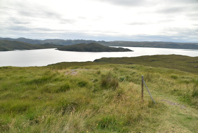
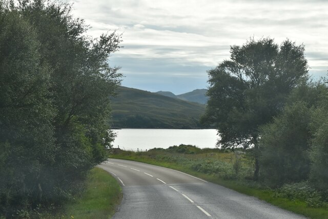
Bad Leathan is a small village located in Ross-shire, a county in the Highland region of Scotland. Situated in the northern part of the country, it is known for its picturesque landscape and natural beauty. The village is primarily surrounded by downs and moorland, offering residents and visitors stunning views of rolling hills and expansive open spaces.

The downs in Bad Leathan are characterized by their gentle slopes and grassy meadows. These areas provide excellent grazing land for livestock, particularly sheep, which are commonly seen dotting the landscape. The downs also attract a variety of bird species, making it a haven for birdwatchers and nature enthusiasts.

The moorland in Bad Leathan consists of vast expanses of heather-covered terrain. This rugged and wild landscape is punctuated by rocky outcrops and peat bogs, creating a unique and diverse ecosystem. Moorland plants such as heather, moss, and gorse thrive in this environment, adding vibrant colors to the landscape throughout the year.

The village itself is small, with a close-knit community that values the tranquility and natural surroundings of the area. There are a few local amenities, including a small shop and a pub, providing basic services to residents and visitors.

For those seeking outdoor activities, Bad Leathan offers ample opportunities for walking, hiking, and cycling. The downs and moorland provide scenic trails, allowing individuals to explore the natural beauty of the area at their leisure.

Overall, Bad Leathan is a charming village nestled in the downs and moorland of Ross-shire, offering a peaceful and idyllic setting for those who appreciate Scotland's natural landscapes.

If you have any feedback on the listing, please let us know in the comments section below.

Bad Leathan Images

Images are sourced within 2km of 57.79692/-5.5763817 or Grid Reference NG8784. Thanks to Geograph Open Source API. All images are credited.

A832 The A832 runs 127 miles from the Black Isle to Braemore Junction <a href="https://www.geograph.org.uk/photo/7232275">NH2077 : Braemore Junction</a>.
<span class="nowrap"><a title="https://www.sabre-roads.org.uk/wiki/index.php?title=A832" rel="nofollow ugc noopener" href="https://www.sabre-roads.org.uk/wiki/index.php?title=A832">Link</a><img style="margin-left:2px;" alt="External link" title="External link - shift click to open in new window" src="https://s1.geograph.org.uk/img/external.png" width="10" height="10"/></span>
A832
The A832 runs 127 miles from the Black Isle to Braemore Junction NH2077 : Braemore Junction. LinkExternal link
NC500 The North Coast 500 is a 516 mile scenic route around the north coast of Scotland, starting and ending at Inverness Castle. The route is also known as the NC500 and was launched in 2015, linking many features in the north Highlands of Scotland in one touring route.
The route has increased visitor numbers to parts of the north of Scotland, which has brought economic benefits to some areas. The increase in traffic has also led to more instances of bad and dangerous driving, as well as damage to the roads and concerns about the environmental impact. 
Apparently the route was amended in 2022 with detours etc being removed.
Wikipedia: <span class="nowrap"><a title="https://en.wikipedia.org/wiki/North_Coast_500" rel="nofollow ugc noopener" href="https://en.wikipedia.org/wiki/North_Coast_500">Link</a><img style="margin-left:2px;" alt="External link" title="External link - shift click to open in new window" src="https://s1.geograph.org.uk/img/external.png" width="10" height="10"/></span> 
Original route map: <span class="nowrap"><a title="https://en.wikipedia.org/wiki/North_Coast_500#/media/File:North_Coast_500,_Scotland.svg" rel="nofollow ugc noopener" href="https://en.wikipedia.org/wiki/North_Coast_500#/media/File:North_Coast_500,_Scotland.svg">Link</a><img style="margin-left:2px;" alt="External link" title="External link - shift click to open in new window" src="https://s1.geograph.org.uk/img/external.png" width="10" height="10"/></span> 
Latest route map: <span class="nowrap"><a title="https://www.northcoast500.com/explore-the-route/" rel="nofollow ugc noopener" href="https://www.northcoast500.com/explore-the-route/">Link</a><img style="margin-left:2px;" alt="External link" title="External link - shift click to open in new window" src="https://s1.geograph.org.uk/img/external.png" width="10" height="10"/></span>
NC500
The North Coast 500 is a 516 mile scenic route around the north coast of Scotland, starting and ending at Inverness Castle. The route is also known as the NC500 and was launched in 2015, linking many features in the north Highlands of Scotland in one touring route. The route has increased visitor numbers to parts of the north of Scotland, which has brought economic benefits to some areas. The increase in traffic has also led to more instances of bad and dangerous driving, as well as damage to the roads and concerns about the environmental impact. Apparently the route was amended in 2022 with detours etc being removed. Wikipedia: LinkExternal link Original route map: LinkExternal link Latest route map: LinkExternal link
View toward Loch Thunaig
Loch Thunaig
Loch Thunaig
Coastal grasses
Coastal grasses
Difficult to sit here! The North Coast 500 is a 516 mile scenic route around the north coast of Scotland, starting and ending at Inverness Castle. The route is also known as the NC500 and was launched in 2015, linking many features in the north Highlands of Scotland in one touring route.
The route has increased visitor numbers to parts of the north of Scotland, which has brought economic benefits to some areas. The increase in traffic has also led to more instances of bad and dangerous driving, as well as damage to the roads and concerns about the environmental impact. 
Apparently the route was amended in 2022 with detours etc being removed.
Wikipedia: <span class="nowrap"><a title="https://en.wikipedia.org/wiki/North_Coast_500" rel="nofollow ugc noopener" href="https://en.wikipedia.org/wiki/North_Coast_500">Link</a><img style="margin-left:2px;" alt="External link" title="External link - shift click to open in new window" src="https://s1.geograph.org.uk/img/external.png" width="10" height="10"/></span> 
Original route map: <span class="nowrap"><a title="https://en.wikipedia.org/wiki/North_Coast_500#/media/File:North_Coast_500,_Scotland.svg" rel="nofollow ugc noopener" href="https://en.wikipedia.org/wiki/North_Coast_500#/media/File:North_Coast_500,_Scotland.svg">Link</a><img style="margin-left:2px;" alt="External link" title="External link - shift click to open in new window" src="https://s1.geograph.org.uk/img/external.png" width="10" height="10"/></span> 
Latest route map: <span class="nowrap"><a title="https://www.northcoast500.com/explore-the-route/" rel="nofollow ugc noopener" href="https://www.northcoast500.com/explore-the-route/">Link</a><img style="margin-left:2px;" alt="External link" title="External link - shift click to open in new window" src="https://s1.geograph.org.uk/img/external.png" width="10" height="10"/></span>
Difficult to sit here!
The North Coast 500 is a 516 mile scenic route around the north coast of Scotland, starting and ending at Inverness Castle. The route is also known as the NC500 and was launched in 2015, linking many features in the north Highlands of Scotland in one touring route. The route has increased visitor numbers to parts of the north of Scotland, which has brought economic benefits to some areas. The increase in traffic has also led to more instances of bad and dangerous driving, as well as damage to the roads and concerns about the environmental impact. Apparently the route was amended in 2022 with detours etc being removed. Wikipedia: LinkExternal link Original route map: LinkExternal link Latest route map: LinkExternal link
A832 The A832 runs 127 miles from the Black Isle to Braemore Junction <a href="https://www.geograph.org.uk/photo/7232275">NH2077 : Braemore Junction</a>.
<span class="nowrap"><a title="https://www.sabre-roads.org.uk/wiki/index.php?title=A832" rel="nofollow ugc noopener" href="https://www.sabre-roads.org.uk/wiki/index.php?title=A832">Link</a><img style="margin-left:2px;" alt="External link" title="External link - shift click to open in new window" src="https://s1.geograph.org.uk/img/external.png" width="10" height="10"/></span>
A832
The A832 runs 127 miles from the Black Isle to Braemore Junction NH2077 : Braemore Junction. LinkExternal link
A832 nearing Tournaig
Loch nan Dilthean
Loch nan Dilthean
Outcrops on Druim Lochan na Ba Caoile
From the A832 viewpoint towards Inverewe Garden A misty day.  The shallow promontory in Loch Ewe is Leac Bhuidhe.
From the A832 viewpoint towards Inverewe Garden
A misty day. The shallow promontory in Loch Ewe is Leac Bhuidhe.
Information board and sculpture describing the place of Loch Ewe in the story of the Arctic convoys during WW2 Loch Ewe (a sea loch) lies beyond.
Information board and sculpture describing the place of Loch Ewe in the story of the Arctic convoys during WW2
Loch Ewe (a sea loch) lies beyond.
Water tower by track A relic of the wartime installations. The track leads to a jetty on Loch Thùrnaig.
Water tower by track
A relic of the wartime installations. The track leads to a jetty on Loch Thùrnaig.
Tournaig Farm
Tournaig Farm
A832 north of Tournaig
Hydrographic survey station, Ploc an Rubha, Ross And Cromarty This hydrographic survey station is located approximately 20m SW of the OS triangulation pillar marked on the map and lies on the edge of a former anti-aircraft gun emplacement.  Unlike other hydrographic survey stations nearby (eg <a href="https://www.geograph.org.uk/photo/4961912">NG8189 : Hydrographic trig pillar, Ru Na Gavern</a>) the plate is not mounted on a pillar, but on concrete directly onto a rock.

The plate shows that it was installed from Seaward Defence Motor Launch 3516 in May 1957.  SDML 3516 was previously designated as HDML 1387 and was used to mark a channel which had been cleared of mines on D-day.  She was later named HMS Medusa.  She has been preserved, is still seaworthy and is shown in <a href="https://www.geograph.org.uk/photo/2977591">TQ2777 : Diamond Jubilee Pageant - ML137 HMS Medusa</a>.
Hydrographic survey station, Ploc an Rubha, Ross And Cromarty
This hydrographic survey station is located approximately 20m SW of the OS triangulation pillar marked on the map and lies on the edge of a former anti-aircraft gun emplacement. Unlike other hydrographic survey stations nearby (eg NG8189 : Hydrographic trig pillar, Ru Na Gavern) the plate is not mounted on a pillar, but on concrete directly onto a rock. The plate shows that it was installed from Seaward Defence Motor Launch 3516 in May 1957. SDML 3516 was previously designated as HDML 1387 and was used to mark a channel which had been cleared of mines on D-day. She was later named HMS Medusa. She has been preserved, is still seaworthy and is shown in TQ2777 : Diamond Jubilee Pageant - ML137 HMS Medusa.
Remains of Second World War jetty, Ob na Bà Ruaidhe, Ross and Cromarty The jetty served an anti-aircraft battery on Ploc an Rubha.  See <span class="nowrap"><a title="http://canmore.org.uk/site/79322" rel="nofollow ugc noopener" href="http://canmore.org.uk/site/79322">Link</a><img style="margin-left:2px;" alt="External link" title="External link - shift click to open in new window" src="https://s1.geograph.org.uk/img/external.png" width="10" height="10"/></span> for details.
Remains of Second World War jetty, Ob na Bà Ruaidhe, Ross and Cromarty
The jetty served an anti-aircraft battery on Ploc an Rubha. See LinkExternal link for details.
Show me another place!

Bad Leathan is located at Grid Ref: NG8784 (Lat: 57.79692, Lng: -5.5763817)

Unitary Authority: Highland

Police Authority: Highlands and Islands

What 3 Words

///brains.plausible.soak. Near Gairloch, Highland

Related Wikis

Tournaig

Tournaig is a remote scattered crofting and fishing hamlet, that sits on the confluence of the sea loch, Loch Thùrnaig to the west, and Loch Nan Dailthean...

Inverewe Garden

Inverewe Garden (Scottish Gaelic: Gàradh Inbhir Iù) is a botanical garden in Wester Ross in the Scottish Highlands. It is located just to the north of...

Londubh

Londubh (Scottish Gaelic: An Lòn Dubh) is a village on the south shore of Loch Ewe in Poolewe, Ross-shire, Scottish Highlands and is in the Scottish council...

Poolewe Stone

The Poolewe Stone is a Class-I Pictish stone discovered in 1992 in the cemetery at Poolewe (Poll Iùbh) in Wester Ross. The stone carries the common Pictish...

Nearby Amenities

Located within 500m of 57.79692,-5.5763817
Source: PGS
Lat/Long: 57.7987431/-5.5834878
Created By: almien_coastlines
Source: PGS
Lat/Long: 57.798671/-5.582017
Source: PGS
Lat/Long: 57.7986008/-5.5811786
Source: PGS
Lat/Long: 57.7989002/-5.5806687
Source: PGS
Lat/Long: 57.7980717/-5.5804436
Source: PGS
Lat/Long: 57.797526/-5.581155
Source: PGS
Lat/Long: 57.797264/-5.5810074
Source: PGS
Lat/Long: 57.79577/-5.5806495
Source: PGS
Lat/Long: 57.7941399/-5.579898
Source: PGS
Lat/Long: 57.7937711/-5.5796097
Source: PGS
Lat/Long: 57.7938533/-5.5790464
Source: PGS
Lat/Long: 57.7934169/-5.5784455
Source: PGS
Lat/Long: 57.7930142/-5.5777257
Source: PGS
Lat/Long: 57.7928141/-5.5776393
Power: pole
Lat/Long: 57.7940467/-5.5728881
Power: pole
Lat/Long: 57.7933299/-5.5732877
Power: pole
Lat/Long: 57.7930332/-5.5728853
Power: pole
Lat/Long: 57.7938308/-5.5724416
Power: pole
Lat/Long: 57.7944653/-5.5720888
Power: pole
Lat/Long: 57.7952291/-5.5717112
Power: pole
Lat/Long: 57.7958856/-5.5713778
Power: pole
Lat/Long: 57.7966934/-5.5709644
Power: pole
Lat/Long: 57.7973419/-5.5705882
Power: pole
Lat/Long: 57.7980902/-5.5701707
Power: pole
Lat/Long: 57.7986916/-5.569862
Power: pole
Lat/Long: 57.794784/-5.5724678
Power: pole
Lat/Long: 57.795564/-5.5720158
Power: pole
Lat/Long: 57.7963233/-5.5715886
Power: pole
Lat/Long: 57.7971847/-5.5710967
Power: pole
Lat/Long: 57.7979088/-5.5706778
Power: pole
Lat/Long: 57.7986167/-5.5702754
Power: pole
Lat/Long: 57.8003291/-5.5726207
Power: pole
Lat/Long: 57.7994612/-5.5714108
Power: pole
Lat/Long: 57.7992805/-5.5706419
Power: pole
Lat/Long: 57.7999003/-5.5714329
Power: pole
Lat/Long: 57.8004921/-5.5722872
Power: pole
Lat/Long: 57.8011566/-5.5737383
Camas a' Bhaid Leathain
Natural: bay
Lat/Long: 57.7976623/-5.5832823
The data included in this document is from www.openstreetmap.org. The data is made available under ODbL.

Have you been to Bad Leathan?

Leave your review of Bad Leathan below (or comments, questions and feedback).