Applecross Forest

Downs, Moorland in Ross-shire

Scotland

Applecross Forest

Rough mountainside Looking south-west up the featureless moorland on the way to Coire Attadale. This grid square contains only one marked feature, a stream Allt Tarsuinn.
Rough mountainside Credit: Neville Goodman

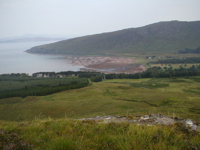
Applecross Forest is located in Ross-shire, Scotland, and is a vast expanse of land characterized by its diverse landscapes, including downs and moorland. It covers an area of approximately 30 square kilometers, making it a significant natural feature in the region.

The forest is known for its breathtaking beauty and untouched wilderness. The downs, with their gently rolling hills, offer stunning panoramic views of the surrounding countryside. They are covered in lush green grass and dotted with wildflowers, creating a picturesque scene that attracts nature enthusiasts and hikers alike.

In contrast, the moorland areas of Applecross Forest provide a unique and rugged terrain. Here, visitors can experience a more challenging and adventurous side of the forest. The moorland is characterized by its heather-covered hills, rocky outcrops, and numerous streams and small lochs. It is also home to a variety of wildlife, including deer, birds of prey, and smaller mammals.

The forest itself is abundant in native trees, such as Scots pine and birch, which provide a habitat for a wide range of flora and fauna. Walking trails and paths wind their way through the forest, allowing visitors to explore the different landscapes and discover the hidden treasures within.

Overall, Applecross Forest in Ross-shire offers a diverse and captivating natural environment, with its downs and moorland creating a stunning contrast. Whether visitors seek a peaceful stroll through the downs or a more challenging hike through the rugged moorland, this forest is a must-visit destination for those seeking to immerse themselves in the beauty of the Scottish countryside.

If you have any feedback on the listing, please let us know in the comments section below.

Applecross Forest Images

Images are sourced within 2km of 57.454265/-5.7331272 or Grid Reference NG7646. Thanks to Geograph Open Source API. All images are credited.

Rough mountainside Looking south-west up the featureless moorland on the way to Coire Attadale. This grid square contains only one marked feature, a stream Allt Tarsuinn.
Rough mountainside
Looking south-west up the featureless moorland on the way to Coire Attadale. This grid square contains only one marked feature, a stream Allt Tarsuinn.
Footbridge At the end of the stalkers' track (easily walked this far, although very wet in places) a footbridge leads over the Allt Coire Attadale. The going is far rougher on the other side. The gorge of the Allt Tarsuinn comes down to the river nearby.
Footbridge
At the end of the stalkers' track (easily walked this far, although very wet in places) a footbridge leads over the Allt Coire Attadale. The going is far rougher on the other side. The gorge of the Allt Tarsuinn comes down to the river nearby.
A jewel of a lochan A  jewel of a lochan: unnamed even on the 1:25000 OS map, and just beside a small knoll that gives a good view down into Coire Attadale <a href="https://www.geograph.org.uk/gridref/NG7846">NG7846</a>.
A jewel of a lochan
A jewel of a lochan: unnamed even on the 1:25000 OS map, and just beside a small knoll that gives a good view down into Coire Attadale NG7846.
A boulder A boulder of Torridonian sandstone lies by a peat hag on the way to Coire Attadale, whose enclosing walls can be seen in the distance. This is not the place to be without a compass (or a GPS) in the mist.
A boulder
A boulder of Torridonian sandstone lies by a peat hag on the way to Coire Attadale, whose enclosing walls can be seen in the distance. This is not the place to be without a compass (or a GPS) in the mist.
Sundew Sundew in a boggy puddle up on the moorland on the way to Coire Attadale.
Sundew
Sundew in a boggy puddle up on the moorland on the way to Coire Attadale.
Small grassy meadow Hidden on this heathery hillside is this wee meadow, where the burns disappear underground, presumably into fine scree.  Because it's better drained than the surrounding area, it supports different flora.
Small grassy meadow
Hidden on this heathery hillside is this wee meadow, where the burns disappear underground, presumably into fine scree. Because it's better drained than the surrounding area, it supports different flora.
Boggy pool Obstacles like this make the going much harder than the map would suggest!
Boggy pool
Obstacles like this make the going much harder than the map would suggest!
Loch Dubh There are two Lochan Dubha (black lochs) at the top of the hill here.  With almost no catchment, they sit as testament to the excess of precipitation over evaporation in Ross-shire.
Loch Dubh
There are two Lochan Dubha (black lochs) at the top of the hill here. With almost no catchment, they sit as testament to the excess of precipitation over evaporation in Ross-shire.
Allt Mòr A substantial river, with plenty of birch trees growing in its valley.
Allt Mòr
A substantial river, with plenty of birch trees growing in its valley.
Departing hind This deer shot up only 20 yards or so in front of me, but by the time I got the camera ready, all I managed was this glimpse of her rear end!
Departing hind
This deer shot up only 20 yards or so in front of me, but by the time I got the camera ready, all I managed was this glimpse of her rear end!
Peat haggs The flat top of this ridge is poorly drained, and thus ideal for the formation of peat.  The deer love to wallow in the peat pools, particularly during the midge season.
Peat haggs
The flat top of this ridge is poorly drained, and thus ideal for the formation of peat. The deer love to wallow in the peat pools, particularly during the midge season.
Boggy pools Peat bogs on the poorly-drained ridge
Boggy pools
Peat bogs on the poorly-drained ridge
Isolated cairn This cairn stands all on its own, with no paths anywhere nearby.  It's a nice place for a view of the Skye Cuillin and Raasay, as can be seen here.
Isolated cairn
This cairn stands all on its own, with no paths anywhere nearby. It's a nice place for a view of the Skye Cuillin and Raasay, as can be seen here.
Tiny lochan Only 50m long by 20m wide, this wee lochan nestles under sandstone scree.
Tiny lochan
Only 50m long by 20m wide, this wee lochan nestles under sandstone scree.
Show me another place!

Applecross Forest is located at Grid Ref: NG7646 (Lat: 57.454265, Lng: -5.7331272)

Unitary Authority: Highland

Police Authority: Highlands and Islands

What 3 Words

///easily.apples.noble. Near Lochcarron, Highland

Nearby Locations

Applecross Forest

Related Wikis

Bealach na Bà

Bealach na Bà (pronounced [bjaLəx na baː]) is a winding single track road through the mountains of the Applecross peninsula, in Wester Ross in the Scottish...

Beinn Bhàn (Applecross)

Beinn Bhàn is a mountain in the highlands of Scotland, lying on the Applecross peninsula, on the north side of Loch Kishorn.Located on the eastern side...

Applecross

Applecross (Scottish Gaelic: A' Chomraich) is a peninsula north-west of Kyle of Lochalsh in the council area of Highland, Scotland. The name Applecross...

Applecross Bay

Applecross Bay is large remote tidal coastal embayment, located next to the small fishing village of Applecross and is on the west coast of the Applecross...

Nearby Amenities

Located within 500m of 57.454265,-5.7331272
Man Made: cairn
Source: survey
Lat/Long: 57.4569912/-5.7318286
The data included in this document is from www.openstreetmap.org. The data is made available under ODbL.

Have you been to Applecross Forest?

Leave your review of Applecross Forest below (or comments, questions and feedback).