Grutness

Settlement in Shetland

Scotland

Grutness

To Sumburgh Head Taken at Jarlshof, settlement site on Shetland dating back 4,000 years and still in use in the 17th century, I am looking across the West Voe of Sumburgh towards Sumburgh Head, the most southerly point of mainland Shetland.
To Sumburgh Head Credit: Carroll Pierce

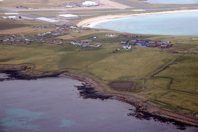
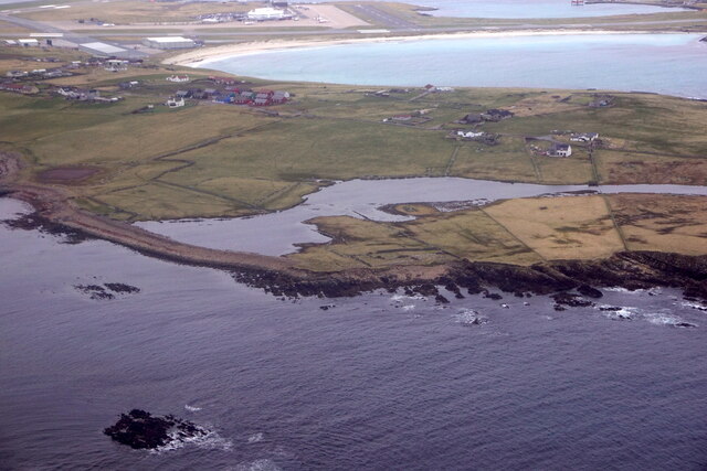
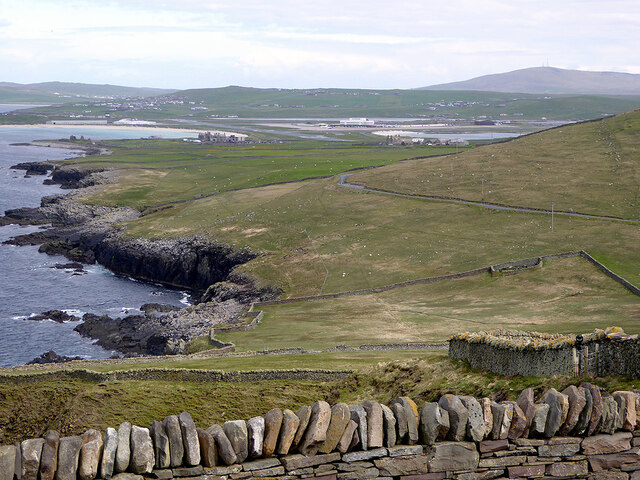
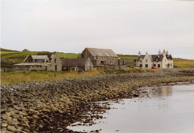
Grutness is a small coastal village located on the southern tip of the Shetland Mainland, the largest island in the Shetland archipelago. Situated in the parish of Dunrossness, Grutness is approximately 20 miles southwest of the island's capital, Lerwick.

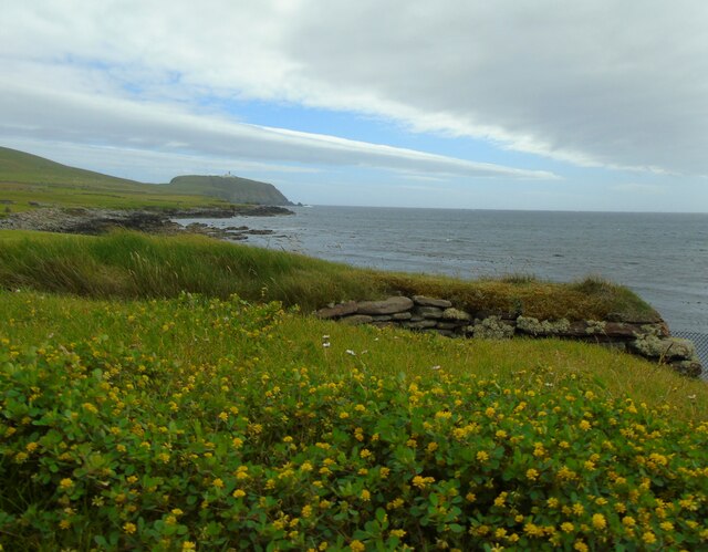
Known for its picturesque setting, Grutness offers stunning views of the North Sea and the surrounding rugged coastline. The village is nestled within a natural harbor, providing a sheltered anchorage for boats and fishing vessels. Its proximity to the sea has shaped the local economy, with fishing and aquaculture playing a significant role in the community.

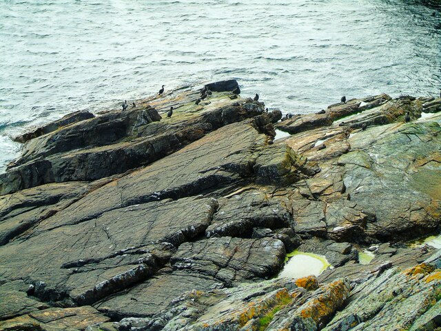
One prominent landmark in Grutness is the Muckle Roe, a small island located just off the coast. This uninhabited island is a popular destination for birdwatchers, who come to observe a variety of seabirds, including puffins and razorbills.

Grutness is also home to the famous Sumburgh Head Lighthouse, situated nearby on the southernmost point of mainland Shetland. This historic lighthouse, built in 1821, offers guided tours and provides visitors with breathtaking panoramic views of the coastline and the surrounding islands.

The village itself has a small population, with a close-knit community that values its rich heritage and traditional way of life. There are a few local amenities, including a primary school and a community hall, which hosts various events throughout the year.

Overall, Grutness is a charming coastal village that offers visitors tranquility, natural beauty, and a glimpse into the unique culture and history of the Shetland Isles.

If you have any feedback on the listing, please let us know in the comments section below.

Grutness Images

Images are sourced within 2km of 59.87408/-1.277447 or Grid Reference HU4010. Thanks to Geograph Open Source API. All images are credited.

To Sumburgh Head Taken at Jarlshof, settlement site on Shetland dating back 4,000 years and still in use in the 17th century, I am looking across the West Voe of Sumburgh towards Sumburgh Head, the most southerly point of mainland Shetland.
To Sumburgh Head
Taken at Jarlshof, settlement site on Shetland dating back 4,000 years and still in use in the 17th century, I am looking across the West Voe of Sumburgh towards Sumburgh Head, the most southerly point of mainland Shetland.
Wheelhouse entrance This is a section of the extensive remains located at Jarlshof, Sumburgh, Shetland. The site was first settled around 4,000 years ago and had a succession of inhabitants through the Bronze and Iron Ages to Norse settlement and medieval farming following on until the 17th century. I am looking at an entrance to the wheelhouse complex on the site.
Wheelhouse entrance
This is a section of the extensive remains located at Jarlshof, Sumburgh, Shetland. The site was first settled around 4,000 years ago and had a succession of inhabitants through the Bronze and Iron Ages to Norse settlement and medieval farming following on until the 17th century. I am looking at an entrance to the wheelhouse complex on the site.
Sumburgh Airport from Jarlshof Taken on the inner path running between the wheelhouse complex and the Norse settlement at Jarlshof, Sumburgh, I am looking across the eastern edge of West Voe to Sumburgh Airport, Shetland's main airport.
Sumburgh Airport from Jarlshof
Taken on the inner path running between the wheelhouse complex and the Norse settlement at Jarlshof, Sumburgh, I am looking across the eastern edge of West Voe to Sumburgh Airport, Shetland's main airport.
Sumburgh Hotel I am near the visitor centre at Jarlshof, Shetland, and looking past the Shetland pony towards the Sumburgh Hotel which is flying the Shetland flag. The hill beyond crowned with radar installation is the landward side of Compass Head.
Sumburgh Hotel
I am near the visitor centre at Jarlshof, Shetland, and looking past the Shetland pony towards the Sumburgh Hotel which is flying the Shetland flag. The hill beyond crowned with radar installation is the landward side of Compass Head.
Scatness from the air
Loch of Gards, Scatness, from the air
Looss Laward from the air
Punds, Eastshore, Virkie, from the air
Male House Sparrow (Passer domesticus) bathing, Grutness
Hudsonian Godwit (Limosa haemastica), Grutness A rare vagrant from North America; only the 5th seen in Britain.
Hudsonian Godwit (Limosa haemastica), Grutness
A rare vagrant from North America; only the 5th seen in Britain.
Sumburgh Head Lighthouse At the summit of this path lie the lighthouse and visitor centre at Sumburgh Head, the southernmost point of mainland Shetland. This is also a nature reserve teeming with birdlife on the cliffs and the rocks below.
Sumburgh Head Lighthouse
At the summit of this path lie the lighthouse and visitor centre at Sumburgh Head, the southernmost point of mainland Shetland. This is also a nature reserve teeming with birdlife on the cliffs and the rocks below.
Shags at Sumburgh Head One of many bird colonies to be found at Sumburgh Head, Shetland, these are shags or skarfs as they are known in Shetland dialect.
Shags at Sumburgh Head
One of many bird colonies to be found at Sumburgh Head, Shetland, these are shags or skarfs as they are known in Shetland dialect.
Minor lighthouse, Sumburgh With Sumburgh Head and its main lighthouse behind me, I am looking back to the car park which is also the location of a minor lighthouse. This light was relocated from its original position at Muckle Roe in 2001 to make way for a lower-maintenance version lit by solar panels.
Minor lighthouse, Sumburgh
With Sumburgh Head and its main lighthouse behind me, I am looking back to the car park which is also the location of a minor lighthouse. This light was relocated from its original position at Muckle Roe in 2001 to make way for a lower-maintenance version lit by solar panels.
Compass Head from the air
View across Sumburgh from the Head With the airport further on.
View across Sumburgh from the Head
With the airport further on.
Communication masts, Sumburgh Viewed from Grutness.
Communication masts, Sumburgh
Viewed from Grutness.
Sumburgh Airport (1) This is Shetland's main airport at Sumburgh to the south of the mainland, taken from the road as it approached from the north.
Sumburgh Airport (1)
This is Shetland's main airport at Sumburgh to the south of the mainland, taken from the road as it approached from the north.
Sumburgh Airport (2) This is Sumburgh Airport, the main airport serving Shetland, taken from the road as it passes its south western side.
Sumburgh Airport (2)
This is Sumburgh Airport, the main airport serving Shetland, taken from the road as it passes its south western side.
Show me another place!

Grutness is located at Grid Ref: HU4010 (Lat: 59.87408, Lng: -1.277447)

Unitary Authority: Shetland Islands

Police Authority: Highlands and Islands

What 3 Words

///relaxed.lightbulb.swipes. Near Sumburgh, Shetland Islands

Related Wikis

Grutness

Grutness is a small settlement and headland at the southern tip of the main island of the Shetland Islands, Scotland. The settlement is within the parish...
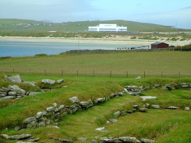
Sumburgh

Sumburgh is a small settlement in the Shetland Islands, Scotland. Sumburgh is located at the south end of the Mainland on Sumburgh Head. Sumburgh Airport...
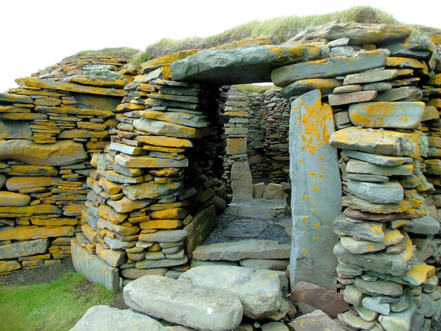
Jarlshof

Jarlshof ( YARLZ-hof) is the best-known prehistoric archaeological site in Shetland, Scotland. It lies in Sumburgh, Mainland, Shetland and has been described...

Dan-Air Flight 0034

Dan-Air Flight 0034 was a fatal accident involving a Hawker Siddeley HS 748 series 1 turboprop aircraft operated by Dan-Air Services Limited on an oil...

Nearby Amenities

Located within 500m of 59.87408,-1.277447
Toilets
Lat/Long: 59.8741924/-1.2776806
Ferry Terminal
Ferry: yes
Public Transport: station
Lat/Long: 59.8743823/-1.278544
Telephone
Booth: K6
Covered: booth
Lat/Long: 59.8740787/-1.2775087
Grutness
Place: hamlet
Lat/Long: 59.8737914/-1.2772983
Bight of Laward
Natural: bay
Lat/Long: 59.8733565/-1.2723756
Power: pole
Lat/Long: 59.8723607/-1.2800899
Power: pole
Lat/Long: 59.8710111/-1.2757263
Bus Stop
Grutness Pier
Bus: yes
Public Transport: platform
Lat/Long: 59.8740579/-1.2775898
End section 6/ beginning section 7
Tourism: viewpoint
Lat/Long: 59.8718133/-1.2723578
End section 7
Tourism: viewpoint
Lat/Long: 59.8743769/-1.2773429
The data included in this document is from www.openstreetmap.org. The data is made available under ODbL.

Have you been to Grutness?

Leave your review of Grutness below (or comments, questions and feedback).