Nanquidno Downs

Downs, Moorland in Cornwall

England

Nanquidno Downs

Chapel Carn Brea - Beacon & Toposcope The Beacon & Toposcope on top of Chapel Carn Brea looking in a roughly westerly direction. The Longships lighthouse can just be seen out to sea.
See shared description below:
Chapel Carn Brea - Beacon & Toposcope Credit: Rob Farrow

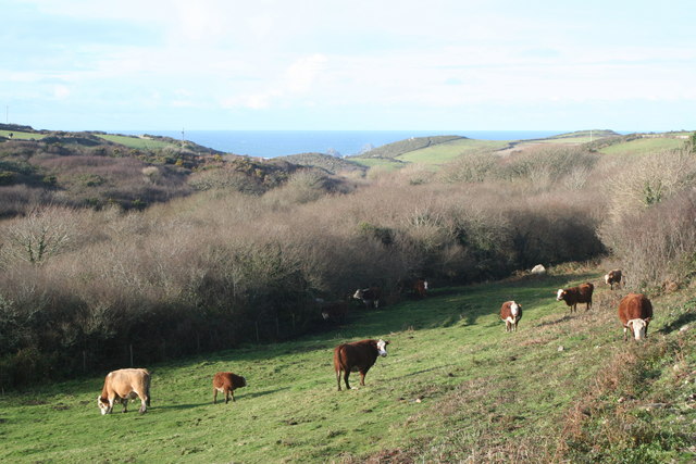
Nanquidno Downs, located in Cornwall, England, is a captivating landscape known for its stunning natural beauty and diverse wildlife. These downs, also referred to as moorland, span an area of approximately 30 square kilometers in the southwest region of the country.

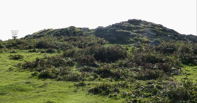
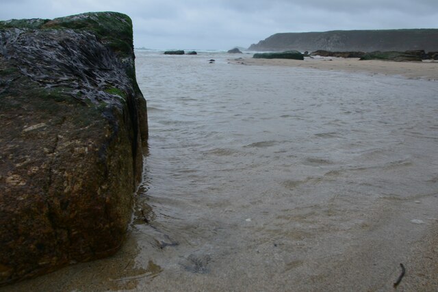
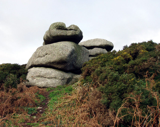
Characterized by rolling hills, open grasslands, and rocky outcrops, Nanquidno Downs offer visitors a serene and tranquil environment to explore. The region is blessed with a mild maritime climate, resulting in abundant rainfall that nurtures a rich and vibrant ecosystem. As a result, the downs are home to a diverse range of flora and fauna, making it a popular destination for nature enthusiasts and birdwatchers.

Visitors to Nanquidno Downs can expect to encounter a variety of plant species, including heather, gorse, and bracken, which create a picturesque and colorful landscape. The undulating terrain also provides a habitat for numerous bird species, such as peregrine falcons, kestrels, and skylarks, making it an ideal location for birdwatching.

Aside from its natural beauty, Nanquidno Downs also hold historical significance. The area is dotted with remnants of ancient settlements, stone circles, and burial sites, offering a glimpse into Cornwall's rich past.

Overall, Nanquidno Downs in Cornwall is a captivating destination for those seeking a peaceful escape amidst nature's wonders. Whether it be for a leisurely stroll, birdwatching, or exploring historical landmarks, this moorland offers a truly immersive experience for all who visit.

If you have any feedback on the listing, please let us know in the comments section below.

Nanquidno Downs Images

Images are sourced within 2km of 50.100258/-5.6815861 or Grid Reference SW3628. Thanks to Geograph Open Source API. All images are credited.

Chapel Carn Brea - Beacon & Toposcope The Beacon & Toposcope on top of Chapel Carn Brea looking in a roughly westerly direction. The Longships lighthouse can just be seen out to sea.
See shared description below:
Chapel Carn Brea - Beacon & Toposcope
The Beacon & Toposcope on top of Chapel Carn Brea looking in a roughly westerly direction. The Longships lighthouse can just be seen out to sea. See shared description below:
Chapel Carn Brea - Summit cairn The cairn atop Chapel Carn Brea with the beacon peeping out on the left.
See <a href="https://www.geograph.org.uk/photo/7013214">SW3828 : Chapel Carn Brea - entrance to Bronze Age chambered cairn</a> for the Bronze Age chambered cairn entrance hidden among these rocks.
See shared description below:
Chapel Carn Brea - Summit cairn
The cairn atop Chapel Carn Brea with the beacon peeping out on the left. See SW3828 : Chapel Carn Brea - entrance to Bronze Age chambered cairn for the Bronze Age chambered cairn entrance hidden among these rocks. See shared description below:
Chapel Carn Brea - entrance to Bronze Age chambered cairn This is the entrance to a Bronze Age chambered cairn atop Chapel Carn Brea. See shared description below.
Chapel Carn Brea - entrance to Bronze Age chambered cairn
This is the entrance to a Bronze Age chambered cairn atop Chapel Carn Brea. See shared description below.
Sennen Cove : Sandy Beach A rocky part of the beach.
Sennen Cove : Sandy Beach
A rocky part of the beach.
Sennen Cove : Sandy Beach A rocky part of the beach.
Sennen Cove : Sandy Beach
A rocky part of the beach.
Sennen Cove : Coastal Scenery A rocky section of the coastline.
Sennen Cove : Coastal Scenery
A rocky section of the coastline.
Sennen Cove : Coastal Scenery Looking across the sandy beach in a rocky part of the cove.
Sennen Cove : Coastal Scenery
Looking across the sandy beach in a rocky part of the cove.
Sennen Cove : Coastal Scenery Looking across the sandy beach.
Sennen Cove : Coastal Scenery
Looking across the sandy beach.
Sennen Cove : Coastal Scenery Looking across the rocky coastline.
Sennen Cove : Coastal Scenery
Looking across the rocky coastline.
Sennen : Escalls Methodist Chapel A chapel and hadstones in the surrounding yard.
Sennen : Escalls Methodist Chapel
A chapel and hadstones in the surrounding yard.
Sennen : Escalls Methodist Chapel Looking from the A30 to the chapel.
Sennen : Escalls Methodist Chapel
Looking from the A30 to the chapel.
Sennen : Escalls Methodist Chapel A chapel off the A30.
Sennen : Escalls Methodist Chapel
A chapel off the A30.
Sennen : A30 Looking along the A30.
Sennen : A30
Looking along the A30.
Sennen : A30 Looking along the A30.
Sennen : A30
Looking along the A30.
Crows-an-Wra : A30 The A30 passing W.C Matthews & Son.
Crows-an-Wra : A30
The A30 passing W.C Matthews & Son.
Eschall's Methodist Church
Bosworlas Rock Basins Also referred to as The Giant's Chair by Dr Borlase in his 1769 book on Penwith's stones.
Bosworlas Rock Basins
Also referred to as The Giant's Chair by Dr Borlase in his 1769 book on Penwith's stones.
The Road into Cot Valley
Show me another place!

Nanquidno Downs is located at Grid Ref: SW3628 (Lat: 50.100258, Lng: -5.6815861)

Unitary Authority: Cornwall

Police Authority: Devon and Cornwall

What 3 Words

///forum.embraced.crypt. Near St Just, Cornwall

Nearby Locations

Nanquidno Downs

Related Wikis

Nanquidno

Nanquidno is a hamlet near St Just in Penwith in west Cornwall, England. It is about half a mile southwest of Kelynack. == References ==

Land's End Airport

Land's End Airport (IATA: LEQ, ICAO: EGHC), situated near St Just in Penwith, 5 NM (9.3 km; 5.8 mi) west of Penzance, in Cornwall, is the most south westerly...

Kelynack

Kelynack (from Cornish: Kelynek is a settlement in west Cornwall, England, UK. == Geography == Kelynack is on the Penwith peninsula approximately four...

Escalls

Escalls is a hamlet in the civil parish of Sennen on the Penwith peninsula in west Cornwall, England, UK. == Toponyny == Escalls previously written as...

Nearby Amenities

Located within 500m of 50.100258,-5.6815861
Barrier: cattle_grid
Lat/Long: 50.0968637/-5.6845596
Power: pole
Lat/Long: 50.1005146/-5.6884477
Power: pole
Transformer: distribution
Lat/Long: 50.0983261/-5.6868705
Power: pole
Lat/Long: 50.0999778/-5.6880292
Power: pole
Lat/Long: 50.0995563/-5.6876752
Power: pole
Lat/Long: 50.098844/-5.6871173
Power: pole
Lat/Long: 50.0983648/-5.686723
Power: pole
Lat/Long: 50.0973952/-5.6859532
Power: pole
Lat/Long: 50.0967225/-5.6854141
The data included in this document is from www.openstreetmap.org. The data is made available under ODbL.

Have you been to Nanquidno Downs?

Leave your review of Nanquidno Downs below (or comments, questions and feedback).