Sand Cliffs

Cliff, Slope in Norfolk Great Yarmouth

England

Sand Cliffs

Scratby village sign, repainted Scratby and California share a sign featuring a lifebelt, the Royal Albert lifeboat, an oar and some ruins with a glazed window, probably representing Scratby church which was demolished in 1548. On the right is what I believe to be a lifeboat shed and perhaps a beacon.
Scratby village sign, repainted Credit: Jane Rackham

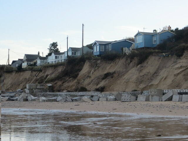
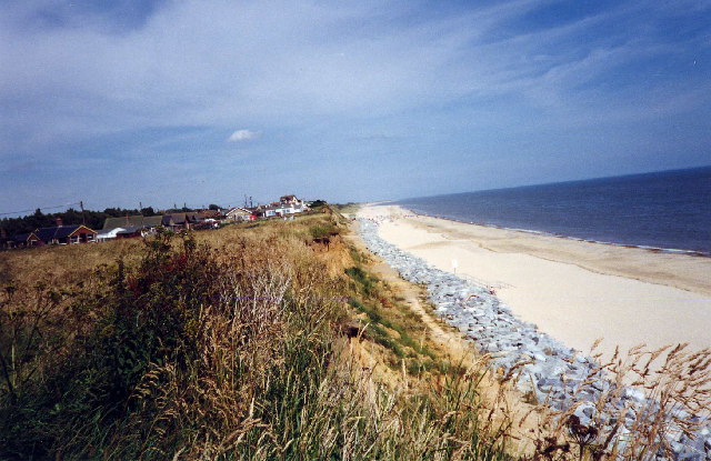
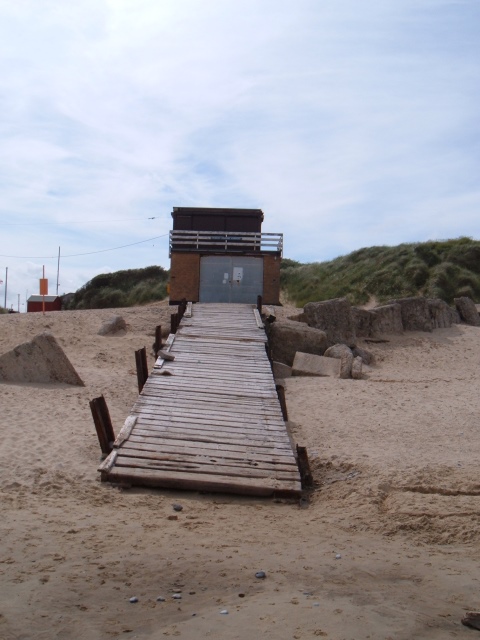
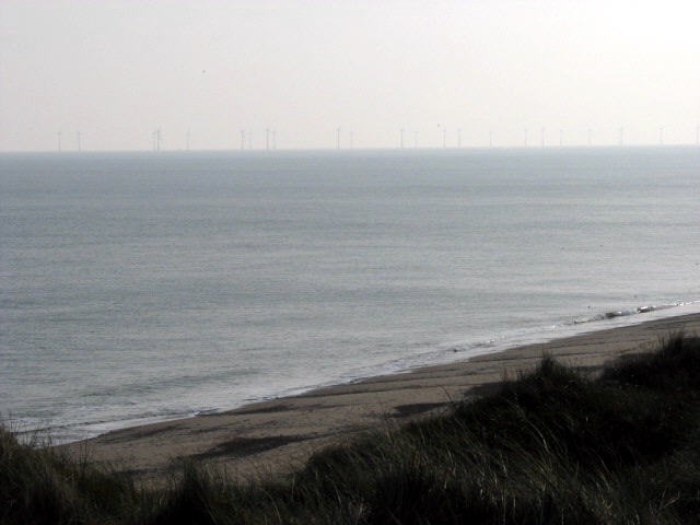
Sand Cliffs, located in Norfolk, England, is a stunning natural formation that stretches along the coastline. These cliffs, also known as sand dunes, are made up of loose, golden sand and rise to an impressive height of up to 20 meters above sea level. The cliffs offer breathtaking views of the North Sea, making it a popular destination for tourists and locals alike.

The sand cliffs are formed by the constant movement of wind and water, which gradually shape and reshape the landscape. Over time, layers of sand accumulate, creating a distinctive layered effect that adds to the beauty of the cliffs. The sand itself is composed of fine grains, giving it a soft and powdery texture.

One of the most notable features of Sand Cliffs is the presence of large, eroded slopes. These slopes, formed by the gradual erosion of the cliffs, create a dramatic and picturesque scene. Visitors can observe the intricate patterns left behind by the wind and water on the slopes, adding to the overall charm of the area.

Sand Cliffs is also home to a diverse range of plant and animal species. The sandy environment provides a unique habitat for various coastal plants that have adapted to the challenging conditions. Additionally, the cliffs attract numerous bird species, making it a popular spot for birdwatching.

Overall, Sand Cliffs in Norfolk offers a captivating experience for nature enthusiasts and those seeking a peaceful retreat. Its stunning views, unique geological formations, and rich biodiversity make it a must-visit destination for anyone exploring the Norfolk coastline.

If you have any feedback on the listing, please let us know in the comments section below.
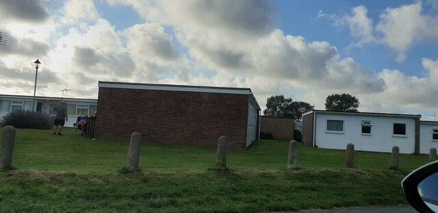
Sand Cliffs Images

Images are sourced within 2km of 52.679167/1.7183716 or Grid Reference TG5115. Thanks to Geograph Open Source API. All images are credited.

Scratby village sign, repainted Scratby and California share a sign featuring a lifebelt, the Royal Albert lifeboat, an oar and some ruins with a glazed window, probably representing Scratby church which was demolished in 1548. On the right is what I believe to be a lifeboat shed and perhaps a beacon.
Scratby village sign, repainted
Scratby and California share a sign featuring a lifebelt, the Royal Albert lifeboat, an oar and some ruins with a glazed window, probably representing Scratby church which was demolished in 1548. On the right is what I believe to be a lifeboat shed and perhaps a beacon.
California bungalows Bungalows in California, from California Road.
California bungalows
Bungalows in California, from California Road.
Houses on edge of eroding cliff - Hemsby Houses exposed to coastal erosion after storms. November 2023
Houses on edge of eroding cliff - Hemsby
Houses exposed to coastal erosion after storms. November 2023
Beach  Scratby Nr Great Yarmouth Norfolk Beach at Scratby Nr Great Yarmouth.
Beach Scratby Nr Great Yarmouth Norfolk
Beach at Scratby Nr Great Yarmouth.
The California Tavern California Nr Great Yarmouth The California Tavern, California Cliffs, Great Yarmouth.
The California Tavern California Nr Great Yarmouth
The California Tavern, California Cliffs, Great Yarmouth.
Caravan Site, California, Norfolk
Sunrise Taken on the beach early one April morning.
Sunrise
Taken on the beach early one April morning.
Sundowner Chalet Park Hemsby near Great Yarmouth
Sundowner Chalet Park
Hemsby near Great Yarmouth
Dunes & Beach - Caister Lower pathway beside the dunes and beach at the northern end of Caister.
Dunes & Beach - Caister
Lower pathway beside the dunes and beach at the northern end of Caister.
Beach at northern end of Caister A section of beach further along from the north end of Caister, this section is a mixture of sand and pebbles.
Beach at northern end of Caister
A section of beach further along from the north end of Caister, this section is a mixture of sand and pebbles.
Station Road going in the direction of California Station Road, and to the right is Flint Cottage. At the extent to which the road can be seen in the picture, but out of view, is the B1159 and crossroad. The road straight over at the crossroad leads to California.
Station Road going in the direction of California
Station Road, and to the right is Flint Cottage. At the extent to which the road can be seen in the picture, but out of view, is the B1159 and crossroad. The road straight over at the crossroad leads to California.
Scratby Road in the direction of Hemsby Scratby Road, seen here running through farmland as it heads out of Scratby and towards Hemsby village.
Scratby Road in the direction of Hemsby
Scratby Road, seen here running through farmland as it heads out of Scratby and towards Hemsby village.
Upper Footpath - North of Caister Upper footpath running alongside the dunes and beach. This section of the beach lies roughly between Caister and California.
Upper Footpath - North of Caister
Upper footpath running alongside the dunes and beach. This section of the beach lies roughly between Caister and California.
Scratby Road and Thoroughfare Lane junction The car is emerging onto Scratby Road from Thoroughfare Lane. Scratby Hall is behind the clump of trees to the right of the picture; in the years 1948-1986 it was a school for boys, named Duncan Hall School – See <span class="nowrap"><a title="www.home.earthlink.net/~duncanhallschool" rel="nofollow ugc noopener" href="http://www.home.earthlink.net/~duncanhallschool">Link</a><img style="margin-left:2px;" alt="External link" title="External link - shift click to open in new window" src="https://s1.geograph.org.uk/img/external.png" width="10" height="10"/></span>
Scratby Road and Thoroughfare Lane junction
The car is emerging onto Scratby Road from Thoroughfare Lane. Scratby Hall is behind the clump of trees to the right of the picture; in the years 1948-1986 it was a school for boys, named Duncan Hall School – See LinkExternal link
Beach Road - Scratby A well looked after and scenic area of Beach Road. Following this road all the way to the coast and then bearing right will take you to California.
Beach Road - Scratby
A well looked after and scenic area of Beach Road. Following this road all the way to the coast and then bearing right will take you to California.
B1159 Scratby Road & Beach Road Junction B1159 Scratby Road and Beach Road junction, not an easy junction to get out of, Scratby Road is quite a busy road this time of the year.
B1159 Scratby Road & Beach Road Junction
B1159 Scratby Road and Beach Road junction, not an easy junction to get out of, Scratby Road is quite a busy road this time of the year.
Lifeboat House, Hemsby A view of the Inshore Rescue Boat Station on Hemsby beach.
Lifeboat House, Hemsby
A view of the Inshore Rescue Boat Station on Hemsby beach.
View across the beach The turbines of Scroby Sands wind farm can be seen in the distance. Scroby Sands wind farm is Great Britain's second offshore wind farm (completed in December 2004). It is located in the North Sea, 2.5 km off the coast of Great Yarmouth. The farm was commissioned by Powergen Renewables Offshore, a division of one of the UK's major electricity producing companies, and it is expected to produce up to a maximum of 60 megawatts of power (sufficient for supplying 41000 homes). The farm has 30 wind turbines, each with three 40 metre blades rotating around a centre-point some 60 metres above the mean sea level on hollow 4.5 metre diameter steel masts, in from 13 to 20 metres depth of water. The masts are piled up to 30 metres into the sea bed, to provide stability on a substrate of shifting sands.

For more detailed information see  <span class="nowrap"><a title="http://en.wikipedia.org/wiki/Scroby_Sands_wind_farm" rel="nofollow ugc noopener" href="http://en.wikipedia.org/wiki/Scroby_Sands_wind_farm">Link</a><img style="margin-left:2px;" alt="External link" title="External link - shift click to open in new window" src="https://s1.geograph.org.uk/img/external.png" width="10" height="10"/></span>
View across the beach
The turbines of Scroby Sands wind farm can be seen in the distance. Scroby Sands wind farm is Great Britain's second offshore wind farm (completed in December 2004). It is located in the North Sea, 2.5 km off the coast of Great Yarmouth. The farm was commissioned by Powergen Renewables Offshore, a division of one of the UK's major electricity producing companies, and it is expected to produce up to a maximum of 60 megawatts of power (sufficient for supplying 41000 homes). The farm has 30 wind turbines, each with three 40 metre blades rotating around a centre-point some 60 metres above the mean sea level on hollow 4.5 metre diameter steel masts, in from 13 to 20 metres depth of water. The masts are piled up to 30 metres into the sea bed, to provide stability on a substrate of shifting sands. For more detailed information see LinkExternal link
Show me another place!

Sand Cliffs is located at Grid Ref: TG5115 (Lat: 52.679167, Lng: 1.7183716)

Administrative County: Norfolk

District: Great Yarmouth

Police Authority: Norfolk

What 3 Words

///ejects.clogging.wildfires. Near Ormesby St Margaret, Norfolk

Nearby Locations

Sand Cliffs

Related Wikis

Blitz and Pieces

Blitz and Pieces is a museum in Scratby in Great Yarmouth, England, owned and operated by Darren Stride. Based on the British Home Front during World...

California Halt railway station

California Halt was a railway station on the Midland and Great Northern Joint Railway which served the Norfolk village of California, England. == History... ==

Scratby Halt railway station

Scratby Halt was a railway station on the Midland and Great Northern Joint Railway which served the Norfolk village of Scratby, England. == History... ==

Duncan Hall School

Duncan Hall School was a boys’ prep school at Scratby Hall in Ormesby St Margaret with Scratby, Norfolk from 1949 to 1986, with girls admitted from 1979...

Ormesby St Margaret with Scratby

Ormesby St Margaret with Scratby is a civil parish in the English county of Norfolk. It is made up of the inland village of Ormesby St Margaret and the...

Great Ormesby railway station

Great Ormesby railway station was a station in Ormesby St Margaret, Norfolk. It was opened in 1877 and later became part of the Midland and Great Northern...

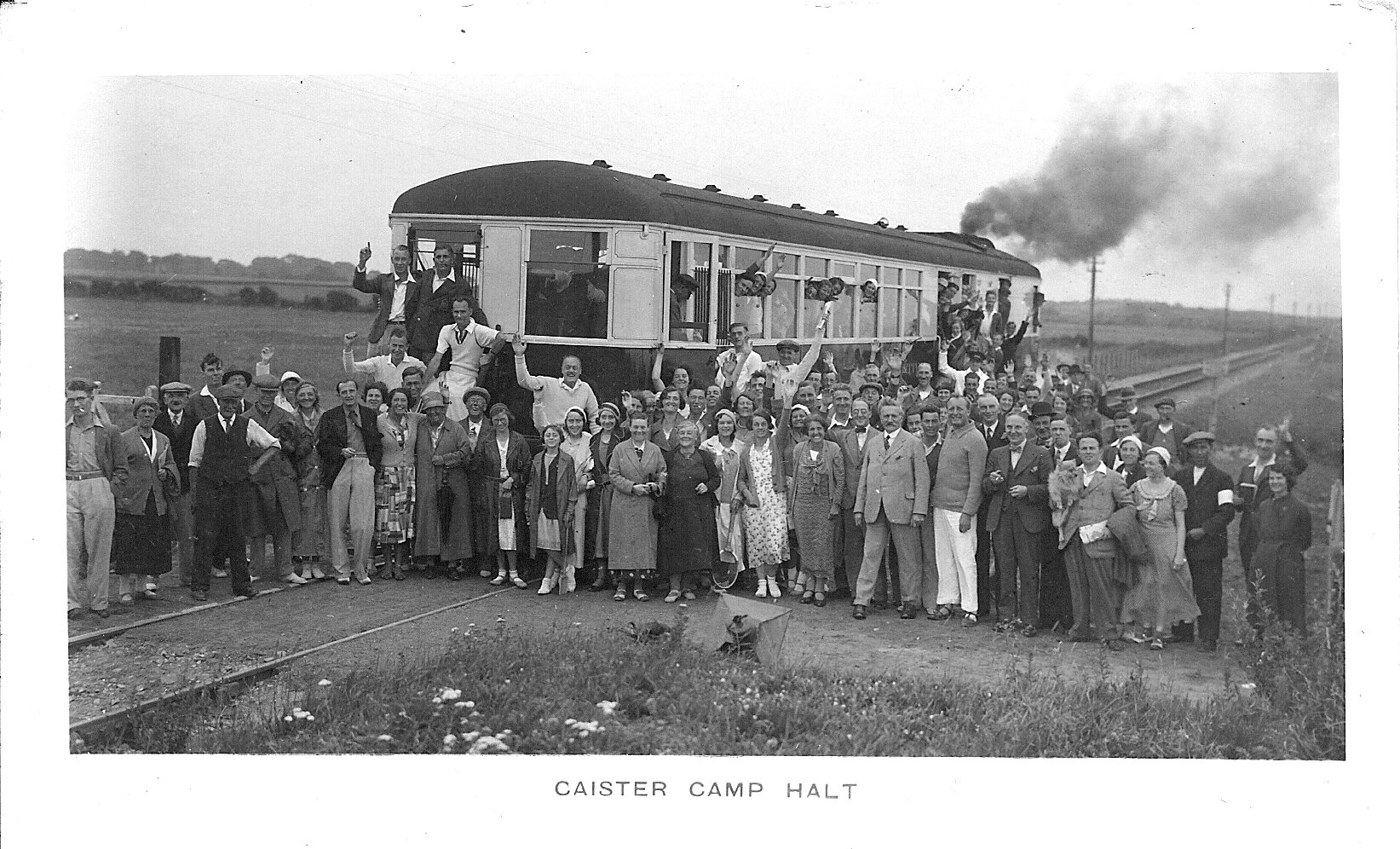
Caister Camp Halt railway station

Caister Camp Halt was a railway station on the Midland and Great Northern Joint Railway which served the holiday camps near the Norfolk coastal town of...

Hemsby railway station

Hemsby railway station was a station in Hemsby, Norfolk. It was on the line between Melton Constable and Great Yarmouth. It was closed in 1959. == References ==

Nearby Amenities

Located within 500m of 52.679167,1.7183716
Scratby
Place: village
Lat/Long: 52.6792799/1.7137473
Bus Stop
Caravan Camp, opp
Bus: yes
Naptan AtcoCode: 2900O0116
Naptan Bearing: S
Naptan BusStopType: CUS
Naptan CommonName: Caravan Camp
Naptan Indicator: opp
Naptan Landmark: opp caravan site
Naptan Locality: California
Naptan NaptanCode: nfodmtmj
Naptan PlusbusZoneRef: YARMTH
Naptan Street: Rottenstone Lane
Naptan Verified: no
Public Transport: platform
Source: naptan_import
Lat/Long: 52.6748945/1.7195212
Bus Stop
Beach Drive, opp
Naptan AtcoCode: 2900O0117
Naptan Bearing: W
Naptan BusStopType: CUS
Naptan CommonName: Beach Drive
Naptan Indicator: opp
Naptan Locality: Scratby
Naptan NaptanCode: nfodmtmp
Naptan Street: Beach Road
Naptan Verified: no
Source: naptan_import
Lat/Long: 52.6782252/1.7128488
Bus Stop
California Avenue, adj
Naptan AtcoCode: 2900O0118
Naptan Bearing: SW
Naptan BusStopType: CUS
Naptan CommonName: California Avenue
Naptan Indicator: adj
Naptan Landmark: Corner California Avenue
Naptan Locality: Scratby
Naptan NaptanCode: nfodmtmt
Naptan Street: Beach Drive
Naptan Verified: no
Source: naptan_import
Lat/Long: 52.6819917/1.7140715
Bus Stop
Beach Drive, adj
Naptan AtcoCode: 2900O012
Naptan Bearing: E
Naptan BusStopType: CUS
Naptan CommonName: Beach Drive
Naptan Indicator: adj
Naptan Landmark: No. 53b Beach Drive
Naptan Locality: Scratby
Naptan NaptanCode: nfodmtpa
Naptan Street: Beach Road
Naptan Verified: no
Shelter: yes
Source: naptan_import
Lat/Long: 52.6784631/1.7113016
Bus Stop
The Promenade, adj
Naptan AtcoCode: 2900O0136
Naptan Bearing: E
Naptan CommonName: The Promenade
Naptan Indicator: adj
Naptan Locality: Scratby
Naptan NaptanCode: nfogptgj
Naptan Street: Beach Road
Naptan Verified: no
Source: naptan_import
Lat/Long: 52.6783287/1.7170014
Bus Stop
The Promenade, opp
Naptan AtcoCode: 2900O0137
Naptan Bearing: W
Naptan CommonName: The Promenade
Naptan Indicator: opp
Naptan Locality: Scratby
Naptan NaptanCode: nfogptgm
Naptan Street: Beach Road
Naptan Verified: no
Source: naptan_import
Lat/Long: 52.6781822/1.7167966
Bus Stop
Caravan Camp, adj
Bus: yes
Naptan AtcoCode: 2900O019
Naptan Bearing: N
Naptan BusStopType: CUS
Naptan CommonName: Caravan Camp
Naptan Indicator: adj
Naptan Landmark: caravan site
Naptan Locality: California
Naptan NaptanCode: nfodmwaw
Naptan PlusbusZoneRef: YARMTH
Naptan Street: Rottenstone Lane
Naptan Verified: no
Public Transport: platform
Source: naptan_import
Lat/Long: 52.6752517/1.7193148
Post Box
Operator: Royal Mail
Post Box Mounting: pier
Post Box Type: lamp
Lat/Long: 52.6819769/1.7140912
Give Way
Lat/Long: 52.6821113/1.7141327
Bench
Backrest: yes
Material: wood
Seats: 3
Lat/Long: 52.6783982/1.7187937
Bench
Backrest: yes
Material: wood
Seats: 3
Lat/Long: 52.6783417/1.7188601
Bench
Backrest: yes
Material: wood
Seats: 3
Lat/Long: 52.6783734/1.7188105
Launderette
Shop: laundry
Lat/Long: 52.6755788/1.7183434
Nisa
Brand: Nisa
Brand Wikidata: Q16999069
Brand Wikipedia: en:Nisa (retailer)
Shop: convenience
Shop 1: souvenir
Lat/Long: 52.6755846/1.718502
Fast Food
Califonia Cliffs Fish & Chippery
Delivery: no
Takeaway: yes
Lat/Long: 52.6755928/1.7186657
Bench
Lat/Long: 52.6784775/1.7115459
Bench
Lat/Long: 52.6784409/1.7116362
Public Bookcase
Book Exchange
Booth: K6
Man Made: telephone_box
Public Bookcase Type: phone_box
Lat/Long: 52.6784612/1.711588
Give Way
Direction: backward
Lat/Long: 52.6784263/1.7114042
The data included in this document is from www.openstreetmap.org. The data is made available under ODbL.

Have you been to Sand Cliffs?

Leave your review of Sand Cliffs below (or comments, questions and feedback).