Beast Cliff

Cliff, Slope in Yorkshire Scarborough

England

Beast Cliff

Dead Roe Deer at OV000000 First Visit.
I have been fascinated by this grid reference for years but didn't manage my first visit to OV0000 until 29 July 2011. We descended the zig-zag path down the cliffs from the Cleveland Way near Ravenscar and I left my daughter and her friends on the shore at NZ993012 while I went solo over the boulders heading south. At OV000000 I found a dead Roe Deer at the top of the beach - mostly bones with salt-dried skin still attached.  I guessed that it had tumbled down the cliff. On the way back I found a fixed rope from the shore to the undercliff and I hauled myself up across the shaly outcrop, hoping to find the old path along the undercliff. Then problems started. The path became overgrown and I got totally tangled up in gorse and briar. I was wearing shorts and my legs were well lacerated. Eventually I managed to hack my way back to the top of the fixed rope and abseiled down to the shore. I wasted over an hour with this foolish detour. By then the tide was coming in and I had to do some wading between the boulders, but the cool sea water soothed my hot bloody legs.

OV0000 Revisited
24 October 2013, a sunny warm autumn day with a low tide. A half decent fisherman's path with 6 or 7 fixed ropes takes you down to the shore at NZ993012. Then it was a scramble over the boulder shore for about 1400 metres down to OV000000. My main aim on this trip was to take some insect samples for the national and Yorkshire recording schemes (insects are mapped by grid reference too!)  Small Tortoiseshell butterflies were flying down the shore, and a micromoth species was out in good numbers. I also found a cranefly, a caterpillar, a snail-killing fly, three species of woodlice, a millipede, an earthworm, a caddis fly, two different ground beetles, a parasitic wasp and a planthopper. Not bad for late October!

So now OV00 will appear on some invertebrate distribution maps. By the time I had bouldered back along the shore and hauled myself up the cliff path I was pretty tired and ready for a cuppa. But it was much easier with the tide out.
Dead Roe Deer at OV000000 Credit: Derek Whiteley

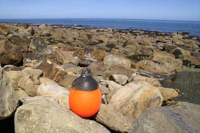
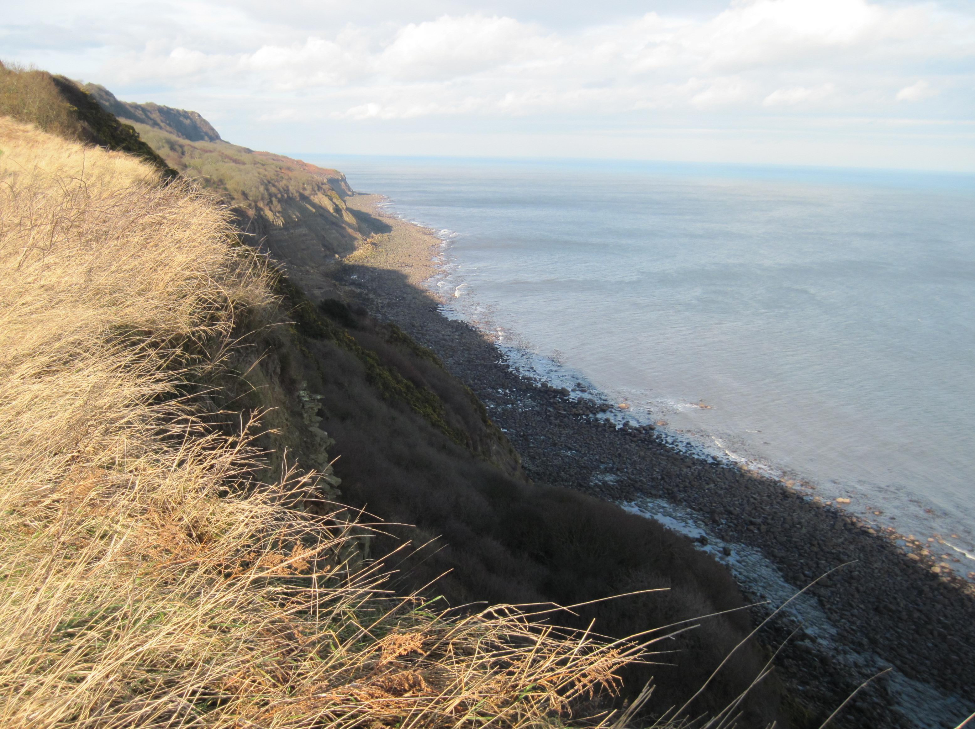
Beast Cliff is a prominent geological feature located in Yorkshire, England. It is a steep cliff that stretches along the coast, providing stunning views of the North Sea. With its rugged beauty and dramatic landscape, Beast Cliff is a popular destination for nature enthusiasts and photographers.

Rising to a height of approximately 100 meters, the cliff is composed of layers of sandstone and shale, which have been shaped by the erosive forces of wind and water over millions of years. The exposed rock formations showcase the region's geological history and offer valuable insights into the Earth's past.

The cliff is home to a diverse range of plant and animal species, including seabirds such as puffins, kittiwakes, and fulmars, which nest in the crevices and ledges. Visitors can often spot these birds gliding above the waves or perched on the cliff's edge. Additionally, the surrounding coastal waters are teeming with marine life, making Beast Cliff a popular spot for fishing and birdwatching.

Access to Beast Cliff is relatively easy, with a well-maintained footpath that runs along the cliff's edge. This allows visitors to explore the area and enjoy the breathtaking views safely. However, caution is advised as the cliff's edge can be unstable in certain areas, and it is important to adhere to safety guidelines.

Overall, Beast Cliff is an awe-inspiring natural wonder, offering visitors a chance to immerse themselves in the beauty of Yorkshire's coastline and witness the power and majesty of nature.

If you have any feedback on the listing, please let us know in the comments section below.

Beast Cliff Images

Images are sourced within 2km of 54.381514/-0.46072281 or Grid Reference TA0099. Thanks to Geograph Open Source API. All images are credited.

Dead Roe Deer at OV000000 First Visit.
I have been fascinated by this grid reference for years but didn't manage my first visit to OV0000 until 29 July 2011. We descended the zig-zag path down the cliffs from the Cleveland Way near Ravenscar and I left my daughter and her friends on the shore at NZ993012 while I went solo over the boulders heading south. At OV000000 I found a dead Roe Deer at the top of the beach - mostly bones with salt-dried skin still attached.  I guessed that it had tumbled down the cliff. On the way back I found a fixed rope from the shore to the undercliff and I hauled myself up across the shaly outcrop, hoping to find the old path along the undercliff. Then problems started. The path became overgrown and I got totally tangled up in gorse and briar. I was wearing shorts and my legs were well lacerated. Eventually I managed to hack my way back to the top of the fixed rope and abseiled down to the shore. I wasted over an hour with this foolish detour. By then the tide was coming in and I had to do some wading between the boulders, but the cool sea water soothed my hot bloody legs.

OV0000 Revisited
24 October 2013, a sunny warm autumn day with a low tide. A half decent fisherman's path with 6 or 7 fixed ropes takes you down to the shore at NZ993012. Then it was a scramble over the boulder shore for about 1400 metres down to OV000000. My main aim on this trip was to take some insect samples for the national and Yorkshire recording schemes (insects are mapped by grid reference too!)  Small Tortoiseshell butterflies were flying down the shore, and a micromoth species was out in good numbers. I also found a cranefly, a caterpillar, a snail-killing fly, three species of woodlice, a millipede, an earthworm, a caddis fly, two different ground beetles, a parasitic wasp and a planthopper. Not bad for late October!

So now OV00 will appear on some invertebrate distribution maps. By the time I had bouldered back along the shore and hauled myself up the cliff path I was pretty tired and ready for a cuppa. But it was much easier with the tide out.
Dead Roe Deer at OV000000
First Visit. I have been fascinated by this grid reference for years but didn't manage my first visit to OV0000 until 29 July 2011. We descended the zig-zag path down the cliffs from the Cleveland Way near Ravenscar and I left my daughter and her friends on the shore at NZ993012 while I went solo over the boulders heading south. At OV000000 I found a dead Roe Deer at the top of the beach - mostly bones with salt-dried skin still attached. I guessed that it had tumbled down the cliff. On the way back I found a fixed rope from the shore to the undercliff and I hauled myself up across the shaly outcrop, hoping to find the old path along the undercliff. Then problems started. The path became overgrown and I got totally tangled up in gorse and briar. I was wearing shorts and my legs were well lacerated. Eventually I managed to hack my way back to the top of the fixed rope and abseiled down to the shore. I wasted over an hour with this foolish detour. By then the tide was coming in and I had to do some wading between the boulders, but the cool sea water soothed my hot bloody legs. OV0000 Revisited 24 October 2013, a sunny warm autumn day with a low tide. A half decent fisherman's path with 6 or 7 fixed ropes takes you down to the shore at NZ993012. Then it was a scramble over the boulder shore for about 1400 metres down to OV000000. My main aim on this trip was to take some insect samples for the national and Yorkshire recording schemes (insects are mapped by grid reference too!) Small Tortoiseshell butterflies were flying down the shore, and a micromoth species was out in good numbers. I also found a cranefly, a caterpillar, a snail-killing fly, three species of woodlice, a millipede, an earthworm, a caddis fly, two different ground beetles, a parasitic wasp and a planthopper. Not bad for late October! So now OV00 will appear on some invertebrate distribution maps. By the time I had bouldered back along the shore and hauled myself up the cliff path I was pretty tired and ready for a cuppa. But it was much easier with the tide out.
OV00 square distant view from Petard Point. Image captured with telephoto lens.
OV00 square distant view from Petard Point.
Image captured with telephoto lens.
Beast Cliff Edge close to Beach Attempting to reach Myriad OV but failed due to safety.
Beast Cliff Edge close to Beach
Attempting to reach Myriad OV but failed due to safety.
The coastline near Common Cliff This photo was taken from NZ9900, within five minutes of low tide. It shows land in all of <a href="https://www.geograph.org.uk/gridref/NZ9900">NZ9900</a>, <a href="https://www.geograph.org.uk/gridref/OV0000">OV0000</a>, <a href="https://www.geograph.org.uk/gridref/SE9999">SE9999</a> and <a href="https://www.geograph.org.uk/gridref/TA0099">TA0099</a>. I have submitted it for the 'difficult' myriad OV to enable the best link with another photo of that square. There is also a link to a photo in TA0099.

For those Geograph-ers who, like me, don't welcome a 3 km (each way) trip across large, unstable and slimy boulders to reach the actual square OV0000, location NZ99610017 provides the best, indeed the only worthwhile view of the square. There is a useful bench there, though I doubt that the National Park authorities placed it with the specific objective of granting the view of OV0000 !

The shore in OV0000 is in the centre of the photo, and is shown in greater detail in <a href="https://www.geograph.org.uk/photo/4383031">OV0000 : The shore in square OV0000</a>. Further away is another stretch of shore at TA00259960;  this is shown in <a href="https://www.geograph.org.uk/photo/4383069">TA0099 : The shoreline north-east of Prospect House Farm</a>. Both photos were taken from the same spot, and at the same time as this one.
The coastline near Common Cliff
This photo was taken from NZ9900, within five minutes of low tide. It shows land in all of NZ9900, OV0000, SE9999 and TA0099. I have submitted it for the 'difficult' myriad OV to enable the best link with another photo of that square. There is also a link to a photo in TA0099. For those Geograph-ers who, like me, don't welcome a 3 km (each way) trip across large, unstable and slimy boulders to reach the actual square OV0000, location NZ99610017 provides the best, indeed the only worthwhile view of the square. There is a useful bench there, though I doubt that the National Park authorities placed it with the specific objective of granting the view of OV0000 ! The shore in OV0000 is in the centre of the photo, and is shown in greater detail in OV0000 : The shore in square OV0000. Further away is another stretch of shore at TA00259960; this is shown in TA0099 : The shoreline north-east of Prospect House Farm. Both photos were taken from the same spot, and at the same time as this one.
The shore in square OV0000 A difficult square to get as a Supplemental, and an even more difficult one to visit! This was taken within five minutes of low tide. <a href="https://www.geograph.org.uk/photo/4383025">OV0000 : The coastline near Common Cliff</a>, taken from the same spot at the same time, puts this shot in the context of the wider landscape.
The shore in square OV0000
A difficult square to get as a Supplemental, and an even more difficult one to visit! This was taken within five minutes of low tide. OV0000 : The coastline near Common Cliff, taken from the same spot at the same time, puts this shot in the context of the wider landscape.
Cleveland Way at Petard Point
Blackthorn by the Cleveland Way
Meeting of the Myriads OV 0000 is a unique square being the sole land representative of the OV myriad. It only just qualifies with around 10 square metres of boulders above the high tide mark. The low tide level is a good 50 metres away and well displayed in this photo. Taking an average of GPS fixes I placed a buoy on the approximate location of OV 000000 which marks the intersection of the four myriads OV, TA, SE and NZ. Each of these has a different first letter because each belongs to a different 500 kilometre square. OV 000000 is the only point in the UK where four such giant myriads intersect.
Meeting of the Myriads
OV 0000 is a unique square being the sole land representative of the OV myriad. It only just qualifies with around 10 square metres of boulders above the high tide mark. The low tide level is a good 50 metres away and well displayed in this photo. Taking an average of GPS fixes I placed a buoy on the approximate location of OV 000000 which marks the intersection of the four myriads OV, TA, SE and NZ. Each of these has a different first letter because each belongs to a different 500 kilometre square. OV 000000 is the only point in the UK where four such giant myriads intersect.
Below Beast Cliff Although War Dike is only 500 metres away from OV000000, a direct ascent is very challenging. It begins up a short ladder in the shallow gully (top centre of the picture) and then traverses through dense undergrowth and boulder fields with hidden chasms before fighting a way through the rather unstable part of Beast Cliff directly under the Cleveland Way.
Below Beast Cliff
Although War Dike is only 500 metres away from OV000000, a direct ascent is very challenging. It begins up a short ladder in the shallow gully (top centre of the picture) and then traverses through dense undergrowth and boulder fields with hidden chasms before fighting a way through the rather unstable part of Beast Cliff directly under the Cleveland Way.
Shipwreck at OV The gull is sitting on a ship's boiler exposed at low tide and possibly from the Premier, a Grimsby trawler wrecked in 1923. The North Yorkshire coastline is littered with wrecks.
Shipwreck at OV
The gull is sitting on a ship's boiler exposed at low tide and possibly from the Premier, a Grimsby trawler wrecked in 1923. The North Yorkshire coastline is littered with wrecks.
Radio Bolt at OV The corroded remains of a rawl-bolt placed in 1987 to secure a radio mast. Because of its difficult access and tiny land surface OV is a highly prized objective for amateur radio enthusiasts.
Radio Bolt at OV
The corroded remains of a rawl-bolt placed in 1987 to secure a radio mast. Because of its difficult access and tiny land surface OV is a highly prized objective for amateur radio enthusiasts.
OV - Distant View from Common Cliff OV lies at sea level just beyond Rocky Point which is below the coastal outline just above and right of centre of this photo. Direct access to OV from the Cleveland Way is problematical because of local topography. The upper band of cliffs top right is composed of oolitic limestone and the lower band just above the sea of very unstable shale and sandstone. The two bands are separated by the undercliff, a broad shelf or plateau, which is thickly vegetated especially in summer.
OV - Distant View from Common Cliff
OV lies at sea level just beyond Rocky Point which is below the coastal outline just above and right of centre of this photo. Direct access to OV from the Cleveland Way is problematical because of local topography. The upper band of cliffs top right is composed of oolitic limestone and the lower band just above the sea of very unstable shale and sandstone. The two bands are separated by the undercliff, a broad shelf or plateau, which is thickly vegetated especially in summer.
OV0000 in 1987.  Old Descent Route, now defunct. This view, taken in July 1987 shows an 8m high Amateur Radio Mast consisting of a tree-trunk bolted via a metal stanchion to a large rock, just inside OV000 square at OV 00011 00017.  This position has since been confirmed via GPS averaging but was at the time determined via a mixture of triangulation and linear measurement.   The final section of the safeguarded route, built between March & July 1987 can be seen down the lower 45m cliff.  The key to this was a 4.3m ladder, purpose built from local materials for direct access into OV0000.  This is shown (at top of frame) fixed to the vertical rock-face within SE9999 square and accessible directly from Beast Cliff’s Plateau, which in turn was accessible down the upper cliff from the Cleveland Way near War Dike Gate.  Foreshore rocks (out of frame) to the left are in TA0099 whilst some pictured on the right are within NZ9900.  This route was gradually destroyed without trace over a 3-year period by storms starting 4th March 1999.  These caused major rock-falls and though the tidal foreshore in the foreground, remains largely unchanged, the cliff shown here is bare of vegetation, unrecognisable and unstable.  A replacement route, 70m NW was opened up on 16th April 2006 but its condition as of January 2009 is unknown.  Photo taken 7th July 1987 – G4YSS.
OV0000 in 1987. Old Descent Route, now defunct.
This view, taken in July 1987 shows an 8m high Amateur Radio Mast consisting of a tree-trunk bolted via a metal stanchion to a large rock, just inside OV000 square at OV 00011 00017. This position has since been confirmed via GPS averaging but was at the time determined via a mixture of triangulation and linear measurement. The final section of the safeguarded route, built between March & July 1987 can be seen down the lower 45m cliff. The key to this was a 4.3m ladder, purpose built from local materials for direct access into OV0000. This is shown (at top of frame) fixed to the vertical rock-face within SE9999 square and accessible directly from Beast Cliff’s Plateau, which in turn was accessible down the upper cliff from the Cleveland Way near War Dike Gate. Foreshore rocks (out of frame) to the left are in TA0099 whilst some pictured on the right are within NZ9900. This route was gradually destroyed without trace over a 3-year period by storms starting 4th March 1999. These caused major rock-falls and though the tidal foreshore in the foreground, remains largely unchanged, the cliff shown here is bare of vegetation, unrecognisable and unstable. A replacement route, 70m NW was opened up on 16th April 2006 but its condition as of January 2009 is unknown. Photo taken 7th July 1987 – G4YSS.
OV from Cleveland Way Path
Oh, that I had the wings of a dOVe! After following Peter Standing's excellent directions <a href="https://www.geograph.org.uk/photo/203863">OV0000 : Below Beast Cliff</a> but stepping onto the slippery boulders three quarters of a mile to the north on a slippery January day rather than during the summer, I decided (wrongly) to take the more direct route to OV000000 along the lower cliffs instead.  This shot, tantalizingly just outside the elusive gridsquare shows how close I was and how hard it would have been to get back up without sprouting wings!  Just look at these curved overhangs in the soft cliff face.  The erosion here is quite evident as my GPS map indicated I was much further away from the cliff edge instead of being perilously close.  Hats off to Peter and partner <a href="https://www.geograph.org.uk/photo/213640">NZ9900 : En route to OV 0000 (2)</a> for reaching what must be one of the top gridsquares to add to ones Geograph collection.

Psalm 55 : 6 
"I said, “Oh, that I had the wings of a dove!  I would fly away and be at rest."
Oh, that I had the wings of a dOVe!
After following Peter Standing's excellent directions OV0000 : Below Beast Cliff but stepping onto the slippery boulders three quarters of a mile to the north on a slippery January day rather than during the summer, I decided (wrongly) to take the more direct route to OV000000 along the lower cliffs instead. This shot, tantalizingly just outside the elusive gridsquare shows how close I was and how hard it would have been to get back up without sprouting wings! Just look at these curved overhangs in the soft cliff face. The erosion here is quite evident as my GPS map indicated I was much further away from the cliff edge instead of being perilously close. Hats off to Peter and partner NZ9900 : En route to OV 0000 (2) for reaching what must be one of the top gridsquares to add to ones Geograph collection. Psalm 55 : 6 "I said, “Oh, that I had the wings of a dove! I would fly away and be at rest."
Staintondale station The disused  Staintondale station.
Staintondale station
The disused Staintondale station.
Staintondale Looking SW from the old railway line towards  Staintondale.
Staintondale
Looking SW from the old railway line towards Staintondale.
Railway line near Staintondale Looking towards Ravenscar.
Railway line near Staintondale
Looking towards Ravenscar.
Show me another place!

Beast Cliff is located at Grid Ref: TA0099 (Lat: 54.381514, Lng: -0.46072281)

Division: North Riding

Administrative County: North Yorkshire

District: Scarborough

Police Authority: North Yorkshire

What 3 Words

///culminate.bulletins.stitch. Near Burniston, North Yorkshire

Nearby Locations

Beast Cliff

Related Wikis

Beast Cliff

Beast Cliff is a steep sea cliff situated about halfway between Whitby and Scarborough on the coast of North Yorkshire in northeastern England. Beast Cliff...

Staintondale

Staintondale (or Stainton Dale) is a small village and civil parish in the Scarborough district of North Yorkshire, England. The village is situated 7...

Bent Rigg radar station

Bent Rigg Radar Station, (also known as Royal Air Force Ravenscar, and Ravenscar tracking station), was a radar site located at Bent Rigg, 0.6 miles (1...

Staintondale railway station

Staintondale railway station, also known as Stainton Dale railway station, was 8 miles (13 km) north of Scarborough and served the hamlet of Staintondale...

Nearby Amenities

Located within 500m of 54.381514,-0.46072281
Source: PGS
Lat/Long: 54.3781744/-0.4561118
Source: PGS
Lat/Long: 54.3792011/-0.456512
Source: PGS
Lat/Long: 54.3801086/-0.4569767
Source: PGS
Lat/Long: 54.3804468/-0.4572336
Source: PGS
Lat/Long: 54.3811713/-0.4575243
Source: PGS
Lat/Long: 54.3820707/-0.4583837
Source: PGS
Lat/Long: 54.3825803/-0.4588769
Source: PGS
Lat/Long: 54.3831139/-0.4592748
Source: PGS
Lat/Long: 54.3833986/-0.4594725
Source: PGS
Lat/Long: 54.3837485/-0.4598586
Source: PGS
Lat/Long: 54.3840221/-0.4602824
Source: PGS
Lat/Long: 54.3843253/-0.4606478
Source: PGS
Lat/Long: 54.384904/-0.4611025
Source: PGS
Lat/Long: 54.3859054/-0.4617686
The data included in this document is from www.openstreetmap.org. The data is made available under ODbL.

Have you been to Beast Cliff?

Leave your review of Beast Cliff below (or comments, questions and feedback).