Hordle Cliff

Cliff, Slope in Hampshire New Forest

England

Hordle Cliff

Downton Park The view of part of the Shorefield caravan park in Downton, Hampshire.
Downton Park Credit: Gordon Griffiths

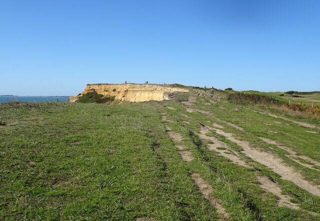
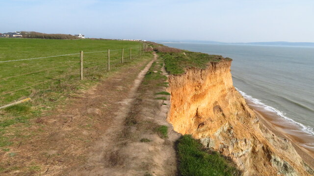
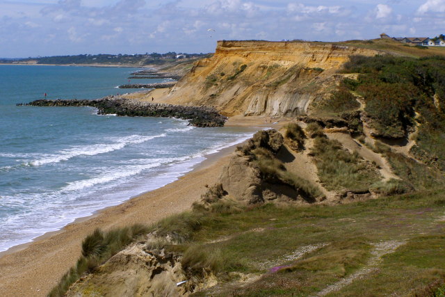
Hordle Cliff is a prominent geographical feature located along the coast of Hampshire, England. It is a steep cliff that stretches for approximately 1 kilometer, offering breathtaking views of the surrounding area. The cliff is situated between the coastal towns of Milford on Sea and Barton on Sea, and is a popular destination for tourists and locals alike.

The cliff is composed primarily of clay and sand, which have eroded over time due to the relentless force of the sea. This erosion has created a distinctive slope that varies in height, with some sections reaching up to 30 meters. The cliff is constantly changing due to weather conditions and coastal erosion, making it a fascinating site for geologists and nature enthusiasts.

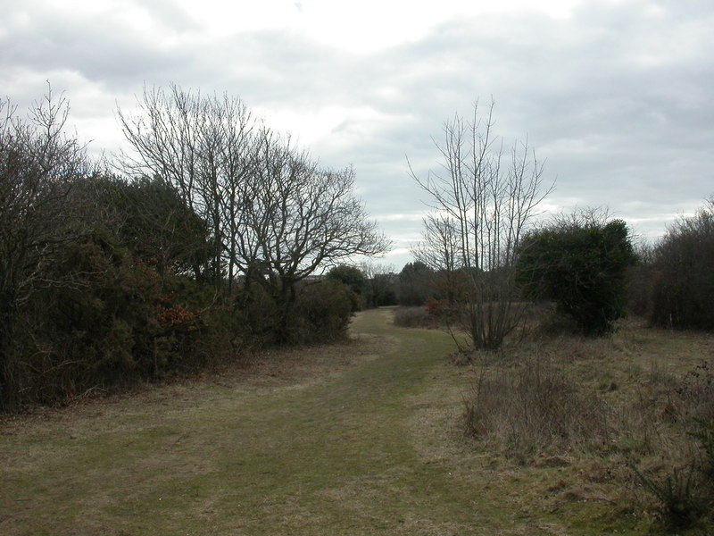
Hordle Cliff is also known for its diverse wildlife. The cliff's vegetation includes a variety of grasses, shrubs, and wildflowers, providing a habitat for numerous species of birds, insects, and small mammals. It is a designated Site of Special Scientific Interest (SSSI) due to its rich biodiversity and geological importance.

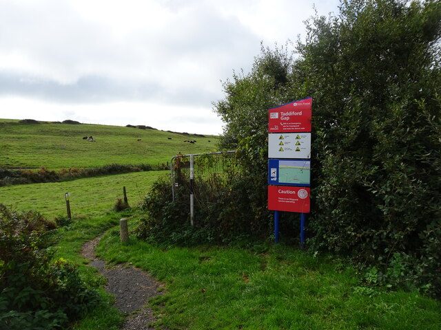
Visitors to Hordle Cliff can enjoy stunning panoramic views of the English Channel and Isle of Wight from the cliff's vantage points. The area is popular for hiking and walking, with several footpaths and trails leading up and along the cliff. However, caution is advised as the cliff is unstable and can be dangerous, especially during periods of heavy rainfall or high winds.

Hordle Cliff is not only a natural wonder but also a valuable educational resource, providing insight into the processes of coastal erosion and the impact of human activities on the environment.

If you have any feedback on the listing, please let us know in the comments section below.

Hordle Cliff Images

Images are sourced within 2km of 50.727586/-1.6200616 or Grid Reference SZ2692. Thanks to Geograph Open Source API. All images are credited.

Downton Park The view of part of the Shorefield caravan park in Downton, Hampshire.
Downton Park
The view of part of the Shorefield caravan park in Downton, Hampshire.
Downton Park View The view of part of the Shorefield caravan park in Downton, Hampshire.
Downton Park View
The view of part of the Shorefield caravan park in Downton, Hampshire.
Coast Scene The sea front at Milford-on-Sea.
Coast Scene
The sea front at Milford-on-Sea.
Crumbling Cliffs There is no sea wall along here and the soft sandy cliffs are being left to nature, which is attacking them quite severely.
There are no properties immediately threatened. The buildings on Park Lane visible in the background are safe for some time to come.  
And when they're not, it will be someone else's budget.
Crumbling Cliffs
There is no sea wall along here and the soft sandy cliffs are being left to nature, which is attacking them quite severely. There are no properties immediately threatened. The buildings on Park Lane visible in the background are safe for some time to come. And when they're not, it will be someone else's budget.
Richmond Court, Park Lane A smart apartment block with good views of the sea.
Well, from this side anyway.
Richmond Court, Park Lane
A smart apartment block with good views of the sea. Well, from this side anyway.
A Recent Landslip More and more of the coast is being lost to the sea all along here.
A detailed study of what's happening is on <span class="nowrap"><a title="https://wessexcoastgeology.soton.ac.uk/Milford-on-Sea.html" rel="nofollow ugc noopener" href="https://wessexcoastgeology.soton.ac.uk/Milford-on-Sea.html">Link</a><img style="margin-left:2px;" alt="External link" title="External link - shift click to open in new window" src="https://s1.geograph.org.uk/img/external.png" width="10" height="10"/></span>
A Recent Landslip
More and more of the coast is being lost to the sea all along here. A detailed study of what's happening is on LinkExternal link
Diverted path at Rook Cliff The clifftop path has been diverted inland and the steps closed due to erosion.
Diverted path at Rook Cliff
The clifftop path has been diverted inland and the steps closed due to erosion.
Clifftop path at Milford on Sea The new path on the left replaces a former route closer to the eroding edge.
Clifftop path at Milford on Sea
The new path on the left replaces a former route closer to the eroding edge.
Inland view towards The Beach House Coastal hotel set back from the cliff edge.
Inland view towards The Beach House
Coastal hotel set back from the cliff edge.
Cliff Scene The view at Barton on Sea along the Hampshire coast.
Cliff Scene
The view at Barton on Sea along the Hampshire coast.
Shorefield Road The view on the Shorefield caravan park in Downton, Hampshire.
Shorefield Road
The view on the Shorefield caravan park in Downton, Hampshire.
Shorefield Park View The view from the Shorefield caravan park along Downton Lane, Hampshire.
Shorefield Park View
The view from the Shorefield caravan park along Downton Lane, Hampshire.
Shorefield Park Reception The view of the Shorefield caravan park in Downton, Hampshire.
Shorefield Park Reception
The view of the Shorefield caravan park in Downton, Hampshire.
Cliff Car Park The view of the Milton Road car park near New Milton, Hampshire.
Cliff Car Park
The view of the Milton Road car park near New Milton, Hampshire.
Taddiford Gap View The view from the Cliff Car Park off the Milton Road near New Milton, Hampshire.
Taddiford Gap View
The view from the Cliff Car Park off the Milton Road near New Milton, Hampshire.
Coastal erosion at Hordle Cliff
The coastal slope and shoreline at Milford on Sea
The coastal path at Milford on Sea
Show me another place!

Hordle Cliff is located at Grid Ref: SZ2692 (Lat: 50.727586, Lng: -1.6200616)

Administrative County: Hampshire

District: New Forest

Police Authority: Hampshire

What 3 Words

///thinkers.blueberry.reason. Near Milford on Sea, Hampshire

Related Wikis

Milford on Sea LNR

Milford on Sea LNR is a 20.6-hectare (51-acre) local nature reserve in Milford on Sea in Hampshire. It is owned and managed by Milford On Sea Parish Council...

Downton, Hampshire

Downton is a hamlet in Hampshire, England, clustered around a crossroads on the A337 road (Lymington to New Milton) with a lane to the sea southwards whilst...

Solent Way

The Solent Way is a 60-mile (97 km) long-distance footpath in Hampshire, southern England. With the exception of a few inland diversions, the path follows...

Milford on Sea

Milford on Sea, often hyphenated, is a large coastal village and civil parish in the New Forest district, on the Hampshire coast, England. The parish had...

Sturt Pond

Sturt Pond is a 10.9-hectare (27-acre) Local Nature Reserve in Milford on Sea in Hampshire. It is owned and managed by Milford On Sea Parish Council....

Everton, Hampshire

Everton is a village in the civil parish of Hordle, 2+1⁄2 miles (4.0 km) west of Lymington, in the English county of Hampshire. == Overview == Everton...

Barton on Sea

Barton on Sea (often hyphenated as Barton-on-Sea) is a cliff-top village in Hampshire, England close to the town New Milton, which is its civil parish...

Highcliffe to Milford Cliffs

Highcliffe to Milford Cliffs is a 110.1-hectare (272-acre) geological Site of Special Scientific Interest which stretches along the south coast of England...

Nearby Amenities

Located within 500m of 50.727586,-1.6200616
Source: PGS
Lat/Long: 50.7253709/-1.614925
Bus Stop
West Road
Bus: yes
Naptan AtcoCode: 1900HA080767
Naptan Bearing: SE
Naptan CommonName: West Road
Naptan Crossing: West Road
Naptan NaptanCode: hamagmag
Naptan Street: North Head
Naptan Verified: no
Public Transport: platform
Shelter: no
Source: naptan_import
Lat/Long: 50.7275991/-1.6141664
Bus Stop
West Road
Bench: yes
Bin: yes
Bus: yes
Naptan AtcoCode: 1900HA080768
Naptan Bearing: NW
Naptan CommonName: West Road
Naptan Crossing: West Road
Naptan NaptanCode: hamagjwt
Naptan Street: North Head
Naptan Verified: no
Public Transport: platform
Shelter: yes
Source: naptan_import
Tactile Paving: no
Lat/Long: 50.7275544/-1.6142376
Bus Stop
Downton Lane
Bench: no
Bin: no
Bus: yes
Naptan AtcoCode: 1900HA080769
Naptan Bearing: NW
Naptan CommonName: Downton Lane
Naptan Crossing: Milford Road
Naptan NaptanCode: hamagjmg
Naptan Street: Cliff Road
Naptan Verified: no
Public Transport: platform
Shelter: no
Source: naptan_import
Tactile Paving: no
Lat/Long: 50.7318866/-1.6217404
Bench
Backrest: yes
Material: wood
Seats: 3
Lat/Long: 50.7264102/-1.6132411
Bench
Backrest: yes
Material: wood
Seats: 3
Lat/Long: 50.7264998/-1.6135949
Bench
Backrest: yes
Material: wood
Seats: 3
Lat/Long: 50.726542/-1.6137843
Generator Method: photovoltaic
Generator Output Electricity: yes
Generator Source: solar
Generator Type: solar_photovoltaic_panel
Location: roof
Power: generator
Lat/Long: 50.7274346/-1.6133632
Generator Method: photovoltaic
Generator Output Electricity: yes
Generator Source: solar
Generator Type: solar_photovoltaic_panel
Location: roof
Power: generator
Lat/Long: 50.7276615/-1.6137135
The data included in this document is from www.openstreetmap.org. The data is made available under ODbL.

Have you been to Hordle Cliff?

Leave your review of Hordle Cliff below (or comments, questions and feedback).