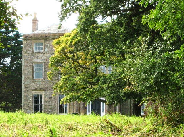
Barr Heugh

Cliff, Slope in Wigtownshire

Scotland

Barr Heugh
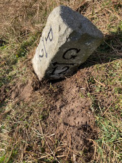
Old milestone On the 14 miles of the A747 north of Port William towards Glenluce on the A75 are about 9 of the typical Wigtownshire milestones.   This one is leaning considerably.   The ground around has been cleared and the legend repainted black.
Old milestone Credit: Jacqueline Crowther

Barr Heugh is a prominent cliff and slope located in Wigtownshire, a historical county in southwestern Scotland. Situated on the shores of the Irish Sea, this natural feature is known for its stunning beauty and geological significance.

The cliff itself stands at an impressive height, towering over the surrounding landscape. Made up of layers of sedimentary rock, it showcases the unique geological history of the region. The exposed rocks offer a glimpse into the ancient past, with formations dating back millions of years.

The slope leading up to the cliff is characterized by lush vegetation, including grasses, shrubs, and wildflowers. This creates a picturesque setting, attracting nature enthusiasts and hikers alike. The view from the top of Barr Heugh is breathtaking, with panoramic vistas of the sea and the surrounding countryside.

In addition to its natural beauty, Barr Heugh is also of historical significance. It has been a site of human activity for centuries, with evidence of ancient settlements and archaeological remains found in the area. These historical artifacts provide insights into the lives of the people who once inhabited the region.

Barr Heugh has become a popular destination for tourists and locals alike, offering opportunities for hiking, birdwatching, and photography. The cliff and slope are also important habitats for various bird species, including nesting seabirds such as fulmars and kittiwakes.

Overall, Barr Heugh in Wigtownshire is a captivating natural landmark, showcasing Scotland's geological and historical heritage. Its towering cliff, scenic slope, and rich biodiversity make it an essential destination for nature enthusiasts and those seeking to explore the region's natural wonders.

If you have any feedback on the listing, please let us know in the comments section below.

Barr Heugh Images

Images are sourced within 2km of 54.781366/-4.6109786 or Grid Reference NX3246. Thanks to Geograph Open Source API. All images are credited.

Old milestone On the 14 miles of the A747 north of Port William towards Glenluce on the A75 are about 9 of the typical Wigtownshire milestones.   This one is leaning considerably.   The ground around has been cleared and the legend repainted black.
Old milestone
On the 14 miles of the A747 north of Port William towards Glenluce on the A75 are about 9 of the typical Wigtownshire milestones. This one is leaning considerably. The ground around has been cleared and the legend repainted black.
Bale store, Port William Silage bales stored on an old alignment of the coast road.
Bale store, Port William
Silage bales stored on an old alignment of the coast road.
Sheep on coastal pasture Here the strip of land below the steep bank is wide enough for fields.
Sheep on coastal pasture
Here the strip of land below the steep bank is wide enough for fields.
Links, Killantrae A stony strip with dense vegetation beside the sea.
Links, Killantrae
A stony strip with dense vegetation beside the sea.
Bank, Killantrae The road runs along a narrow strip between the sea and a steep bank.
Bank, Killantrae
The road runs along a narrow strip between the sea and a steep bank.
A747, Barr The road keeps to a narrow coastal strip with a steep vegetated bank to landward.
A747, Barr
The road keeps to a narrow coastal strip with a steep vegetated bank to landward.
Overgrown bank, Milton The steep slopes above the road and raised beach are covered with dense vegetation.
Overgrown bank, Milton
The steep slopes above the road and raised beach are covered with dense vegetation.
A747, Milton The road runs along a narrow strip between sea and steep vegetated slopes, probably a raised beach.
A747, Milton
The road runs along a narrow strip between sea and steep vegetated slopes, probably a raised beach.
Links, Airyolland The narrow coastal strip beside the A747.
Links, Airyolland
The narrow coastal strip beside the A747.
A747, Airyolland
A747, Airyolland
Landslip, Airyolland A scar which will soon be colonised by vegetation.
Landslip, Airyolland
A scar which will soon be colonised by vegetation.
Rough Sea Looking towards Philip and Mary across the waves.
Rough Sea
Looking towards Philip and Mary across the waves.
Sand hoppers A very windy day and a very high tide have driven a multitude of sand hoppers to shelter in a handy footprint.
Sand hoppers
A very windy day and a very high tide have driven a multitude of sand hoppers to shelter in a handy footprint.
Old milestone The first milestone north of Port William, in the distance, has had vegetation cleared and been painted by a Milestone Society member.
Old milestone
The first milestone north of Port William, in the distance, has had vegetation cleared and been painted by a Milestone Society member.
Old milestone Once leaning, this milestone has been cleared of vegetation, set upright and painted by a Milestone Society member.
Old milestone
Once leaning, this milestone has been cleared of vegetation, set upright and painted by a Milestone Society member.
Old milestone The position of this milestone at the back of the grassy verge sees it almost surrounded by yellow gorse on the hillside.   The rough back of the stone can also be seen.  Only the two front faces of these milestones were worked flat to have the legends inscribed.
Old milestone
The position of this milestone at the back of the grassy verge sees it almost surrounded by yellow gorse on the hillside. The rough back of the stone can also be seen. Only the two front faces of these milestones were worked flat to have the legends inscribed.
Old milestone Another of the milestones north of Port William that has had the vegetation cleared by a Milestone Society member and then repainted.   Most of the Wigtownshire milestones are of the same shape with just a single letter on each face and an arrow indicating the places to and from.   On this road the G is for Glenluce.
Old milestone
Another of the milestones north of Port William that has had the vegetation cleared by a Milestone Society member and then repainted. Most of the Wigtownshire milestones are of the same shape with just a single letter on each face and an arrow indicating the places to and from. On this road the G is for Glenluce.
Old milestone A view from the milestone along this lovely coastal road on a fine day.
Old milestone
A view from the milestone along this lovely coastal road on a fine day.
Show me another place!

Barr Heugh is located at Grid Ref: NX3246 (Lat: 54.781366, Lng: -4.6109786)

Unitary Authority: Dumfries and Galloway

Police Authority: Dumfries and Galloway

What 3 Words

///stance.abandons.napped. Near Whithorn, Dumfries & Galloway

Nearby Locations

Barr Heugh

Related Wikis

Elrig

Elrig (Scottish Gaelic: An Eileirg, meaning "the deer run") is a clachan or hamlet in the historical county of Wigtownshire in Dumfries and Galloway...

Port William, Dumfries and Galloway

Port William (Scottish Gaelic: Cill na TrĂ ghad) is a fishing village in the parish of Mochrum in the historical county of Wigtownshire, Dumfries and Galloway...

Mochrum

Mochrum () is a coastal civil and Church of Scotland parish situated to the east of Luce Bay on the Machars peninsula and 8 miles (13 km) southwest of...

Drumtroddan standing stones

The Drumtroddan standing stones (grid reference NX 36449 44300) are a small Neolithic or Bronze Age stone alignment in the parish of Mochrum, Wigtownshire...

Monreith House

Monreith House is a category A listed Georgian mansion located 1.5 kilometres (0.93 mi) east of the village of Port William in Mochrum parish in the historical...

Machars

The Machars (Scottish Gaelic: Machair Ghallghaidhealaibh) is a peninsula in the historical county of Wigtownshire in Galloway in the south-west of Scotland...

Wren's Egg

The Wren's Egg (grid reference NX 3610 4199) is the name given to a set of late Neolithic or Bronze Age stone monuments in the parish of Glasserton, Wigtownshire...

Doon of May

The Doon of May is a conifer plantation associated with an Iron Age hill fort in Dumfries and Galloway, south-west Scotland. Located around 14 kilometres...

Nearby Amenities

Located within 500m of 54.781366,-4.6109786
Source: PGS
Lat/Long: 54.7821069/-4.6183655
Source: PGS
Lat/Long: 54.781946/-4.6177003
Source: PGS
Lat/Long: 54.781561/-4.616759
Source: PGS
Lat/Long: 54.7813892/-4.6164558
Source: PGS
Lat/Long: 54.7812345/-4.6160803
Source: PGS
Lat/Long: 54.7809746/-4.6157155
Source: PGS
Lat/Long: 54.780919/-4.6154365
Source: PGS
Lat/Long: 54.7807643/-4.6151039
Source: PGS
Lat/Long: 54.7806591/-4.6148035
Source: PGS
Lat/Long: 54.780591/-4.6144817
Source: PGS
Lat/Long: 54.7806715/-4.6140632
Source: PGS
Lat/Long: 54.7808942/-4.6136448
Source: PGS
Lat/Long: 54.7810303/-4.6130225
Source: PGS
Lat/Long: 54.7809499/-4.612132
Source: PGS
Lat/Long: 54.78069/-4.611027
Source: PGS
Lat/Long: 54.780523/-4.6105764
Source: PGS
Lat/Long: 54.7803373/-4.6101365
Source: PGS
Lat/Long: 54.7799847/-4.6096751
Source: PGS
Lat/Long: 54.7797928/-4.6096966
Source: PGS
Lat/Long: 54.7795701/-4.6095035
Source: PGS
Lat/Long: 54.7798423/-4.6081624
Source: PGS
Lat/Long: 54.7797372/-4.6076045
Source: PGS
Lat/Long: 54.7794401/-4.6067998
Source: PGS
Lat/Long: 54.7790503/-4.6062848
Source: PGS
Lat/Long: 54.7780417/-4.6067033
Source: PGS
Lat/Long: 54.7777509/-4.6071539
Elrig
Naptan AtcoCode: 680000869111
Naptan Bearing: NW
Naptan BusStopType: CUS
Naptan CommonName: Elrig
Naptan Indicator: opp Road End
Naptan Landmark: C26
Naptan NaptanCode: 34237243
Naptan Notes: none
Naptan Street: A747
Naptan Verified: no
Source: naptan_import
Lat/Long: 54.781667/-4.6141834
Elrig
Naptan AtcoCode: 680000869222
Naptan Bearing: SE
Naptan BusStopType: CUS
Naptan CommonName: Elrig
Naptan Indicator: Road End
Naptan Landmark: C26
Naptan NaptanCode: 34237242
Naptan Notes: none
Naptan Street: A747
Naptan Verified: no
Source: naptan_import
Lat/Long: 54.7817139/-4.6140931
Power: pole
Lat/Long: 54.7821589/-4.6149974
Power: pole
Lat/Long: 54.7829021/-4.6152655
Power: pole
Lat/Long: 54.7836236/-4.6155078
Power: pole
Lat/Long: 54.7843546/-4.6157594
The data included in this document is from www.openstreetmap.org. The data is made available under ODbL.

Have you been to Barr Heugh?

Leave your review of Barr Heugh below (or comments, questions and feedback).