Eastern Cliff

Cliff, Slope in Cornwall

England

Eastern Cliff

Lichen-covered rock
Lichen-covered rock Credit: Ian Cunliffe

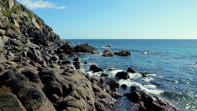
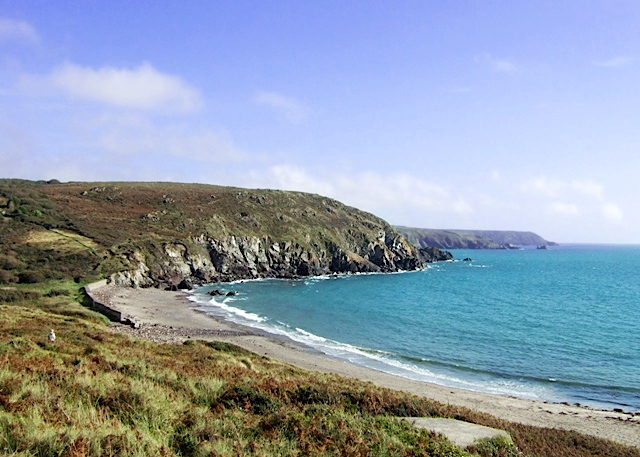
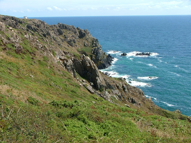
Eastern Cliff is a prominent geographical feature located in Cornwall, a county in the southwestern region of England. It is a steep and imposing cliff that stretches along the eastern coast of Cornwall, overlooking the Atlantic Ocean. Formed through centuries of erosion by wind and waves, Eastern Cliff stands as a captivating landmark in the area.

The cliff is characterized by its sheer vertical drop, which ranges in height from 30 to 100 meters, depending on the specific location. Its rugged and rocky facade is composed of various types of sedimentary rocks, including sandstone and shale, which display a stunning array of colors, from deep reds to pale yellows.

Due to its proximity to the ocean, Eastern Cliff offers breathtaking panoramic views of the Atlantic, with its crashing waves and dramatic tides. The cliff also serves as a nesting site for various seabird species, including puffins, gulls, and cormorants, making it a popular spot for birdwatchers and nature enthusiasts.

Eastern Cliff is easily accessible via a network of footpaths and trails that wind along its edge, allowing visitors to explore its natural beauty firsthand. However, caution is advised when venturing close to the cliff's edge, as the terrain can be unstable and the drop-offs steep.

Overall, Eastern Cliff in Cornwall is a visually striking and ecologically significant geological formation, offering visitors a chance to marvel at the raw power of nature and experience the stunning coastal scenery that Cornwall is renowned for.

If you have any feedback on the listing, please let us know in the comments section below.

Eastern Cliff Images

Images are sourced within 2km of 50.007824/-5.1488069 or Grid Reference SW7416. Thanks to Geograph Open Source API. All images are credited.

Lichen-covered rock
Lichen-covered rock
Carrick Luz
Carrick Luz
Old Serpentine Works, Poltesco The ruins of the serpentine factory - with the pilchard tower on the end, taken from the pebbly beach at Carleon Cove.
Old Serpentine Works, Poltesco
The ruins of the serpentine factory - with the pilchard tower on the end, taken from the pebbly beach at Carleon Cove.
Downas Cove From Beagles Point, looking down on the cove with Carrick Luz beyond.
Downas Cove
From Beagles Point, looking down on the cove with Carrick Luz beyond.
Downas Cove Taking by the stream which flows through Downas Valley and into the sea at the cove.
Downas Cove
Taking by the stream which flows through Downas Valley and into the sea at the cove.
Downas Cove Looking down on the cove from The Gaider.
Downas Cove
Looking down on the cove from The Gaider.
Lighthouse ornament created from serpentine rock An example of the traditional lighthouse ornament created from the local rock known as serpentine. There are currently (2011) only five craftsmen and one young apprentice creating such ornaments.
Lighthouse ornament created from serpentine rock
An example of the traditional lighthouse ornament created from the local rock known as serpentine. There are currently (2011) only five craftsmen and one young apprentice creating such ornaments.
Capstan Room - Old Pilchard Fishing Industry site It is within this now roofless building that the workers would have walked round and round winding the rope around a vertical capstan to gradually wind in the fishing nets or, probably was used to pull the small boats up from the sea onto the beach. <a href="https://www.geograph.org.uk/photo/2378147">SW7215 : Old Serpentine Works, Poltesco</a> <a href="https://www.geograph.org.uk/photo/1263630">SW7215 : Poltesco Serpentine Works 1</a>

The path shown leads down to Carleon Cove along a sloping rocky incline.
Capstan Room - Old Pilchard Fishing Industry site
It is within this now roofless building that the workers would have walked round and round winding the rope around a vertical capstan to gradually wind in the fishing nets or, probably was used to pull the small boats up from the sea onto the beach. SW7215 : Old Serpentine Works, Poltesco SW7215 : Poltesco Serpentine Works 1 The path shown leads down to Carleon Cove along a sloping rocky incline.
Eastern Cliff West of Kennack Sands at approaching high tide (didn't want to go any further into the square!)
Eastern Cliff
West of Kennack Sands at approaching high tide (didn't want to go any further into the square!)
The Caerverracks This rocky section splits the two sections of Kennack Sands.
View south-west towards Lizard Point.
The Caerverracks
This rocky section splits the two sections of Kennack Sands. View south-west towards Lizard Point.
The road to Kennack Sands
A nice day at the beach? Kennack Sands and the lady was waiting for her grandchildren to return.
A nice day at the beach?
Kennack Sands and the lady was waiting for her grandchildren to return.
Pond at Arrowan
Pond at Arrowan
Hay meadow South of the road to Gwenter
The road to Gwenter
The road to Gwenter
A rock garden (literally) in Gwenter No scale evident but the main rock was probably 3 metres in height.
A rock garden (literally) in Gwenter
No scale evident but the main rock was probably 3 metres in height.
Start of footpath to Kennack Sands Not easily located and it is routed through two private gardens.
Start of footpath to Kennack Sands
Not easily located and it is routed through two private gardens.
Footpath from Gwenter to Lower Treland
Show me another place!

Eastern Cliff is located at Grid Ref: SW7416 (Lat: 50.007824, Lng: -5.1488069)

Unitary Authority: Cornwall

Police Authority: Devon and Cornwall

What 3 Words

///plums.revamped.hairpin. Near Landewednack, Cornwall

Related Wikis

Kennack Sands

Kennack Sands is a beach and sand-dune system on the east coast of the Lizard Peninsula, Cornwall, England, UK. == Geography == The beach is approximately...

Gwenter

Gwenter (Cornish: Gwynstir) is a hamlet in the parish of St Keverne (where the 2011 census population was included), Cornwall, England.Gwenter lies within...

Kennack to Coverack

Kennack to Coverack is a coastal Site of Special Scientific Interest (SSSI) on the Lizard Peninsula in Cornwall, England, UK, noted for both its biological...

Trelan

Trelan (Cornish: Trelann) is a hamlet in the parish of St Keverne in Cornwall, England, United Kingdom, on the eastern borders of Goonhilly Downs.Trelan...

Nearby Amenities

Located within 500m of 50.007824,-5.1488069
Source: PGS
Lat/Long: 50.0077095/-5.1555683
Green Saddle
Is In: Cornwall, England, UK
Place: locality
Lat/Long: 50.0060466/-5.1498378
The data included in this document is from www.openstreetmap.org. The data is made available under ODbL.

Have you been to Eastern Cliff?

Leave your review of Eastern Cliff below (or comments, questions and feedback).