Aoineadh Fada

Cliff, Slope in Argyllshire

Scotland

Aoineadh Fada

Rubha na Faoilinn Rubha na Faoilinn is the headland at the southeast side of the entrance to Loch Buie, and is exposed to swell even on a very calm day such as the one seen here. The ridge behind the wave-cut platform rises to 301m at Cnoc a'Ghille, though the skyline seen in the picture is nearer and lower.
Rubha na Faoilinn Credit: Andy Waddington

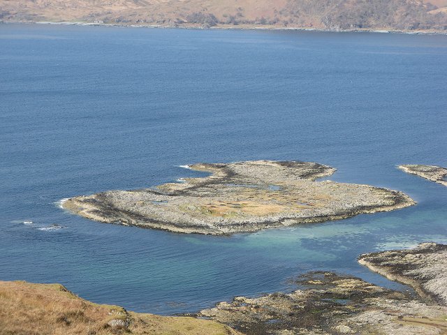
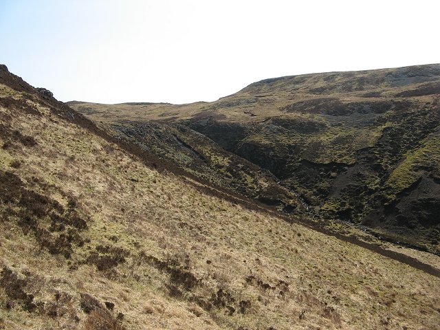
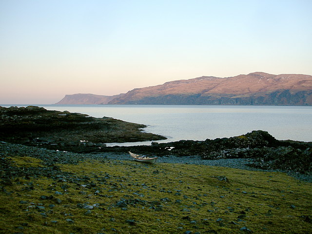
Aoineadh Fada, also known as the Cliff Slope, is a prominent geographical feature located in Argyllshire, Scotland. This majestic cliff slope is situated on the western coast of the region, overlooking the vast expanse of the Atlantic Ocean.

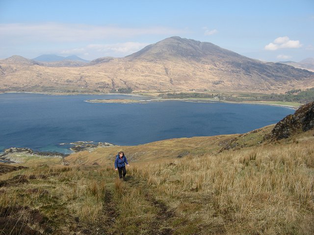
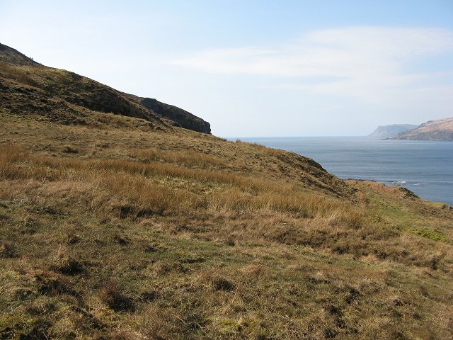
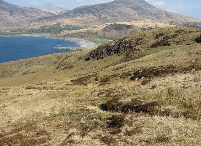
Rising to an impressive height of approximately 200 meters, Aoineadh Fada attracts visitors and nature enthusiasts from near and far. The cliff slope offers breathtaking panoramic views of the surrounding landscape, with its rugged rock formations, lush greenery, and the endless expanse of the ocean stretching out into the horizon.

The area surrounding Aoineadh Fada is rich in biodiversity, providing a habitat for various species of birds, marine life, and plant species. The cliff slope is home to a variety of seabirds, including gannets, puffins, and guillemots, which nest in the crevices and ledges of the rocks. The pristine waters below the cliff slope are also teeming with marine life, making it a popular spot for fishing and diving enthusiasts.

For those seeking outdoor adventure, Aoineadh Fada offers opportunities for hiking and exploration. Several walking trails wind their way along the edge of the cliff, providing visitors with a chance to experience the stunning natural beauty up close. However, caution is advised as the cliff slope can be steep and treacherous in certain areas.

Aoineadh Fada, with its dramatic cliffs, breathtaking views, and abundant wildlife, is a true gem of Argyllshire. It serves as a testament to the raw and untamed beauty of the Scottish coast, captivating all who venture to its edge.

If you have any feedback on the listing, please let us know in the comments section below.

Aoineadh Fada Images

Images are sourced within 2km of 56.327972/-5.8711519 or Grid Reference NM6021. Thanks to Geograph Open Source API. All images are credited.

Rubha na Faoilinn Rubha na Faoilinn is the headland at the southeast side of the entrance to Loch Buie, and is exposed to swell even on a very calm day such as the one seen here. The ridge behind the wave-cut platform rises to 301m at Cnoc a'Ghille, though the skyline seen in the picture is nearer and lower.
Rubha na Faoilinn
Rubha na Faoilinn is the headland at the southeast side of the entrance to Loch Buie, and is exposed to swell even on a very calm day such as the one seen here. The ridge behind the wave-cut platform rises to 301m at Cnoc a'Ghille, though the skyline seen in the picture is nearer and lower.
Between Rubha na Faoilinn and Lord Lovat's Bay The sea kayaker coming from Loch Buie passes Rubha na Faoilinn into the open Firth of Lorn and, heading east, starts a committing stretch of coast exposed to the swell and with few landing places for ten miles. This is the first bit of that coast, with the shore becoming increasingly rocky and running to cliffs which soon rise to 280m. This photo was taken on a trip in very fine stable weather under a high pressure area with very little swell and no wind, so conditions were very benign, but it is still a three hour paddle to reach the next beach with an escape route to the roads.
Between Rubha na Faoilinn and Lord Lovat's Bay
The sea kayaker coming from Loch Buie passes Rubha na Faoilinn into the open Firth of Lorn and, heading east, starts a committing stretch of coast exposed to the swell and with few landing places for ten miles. This is the first bit of that coast, with the shore becoming increasingly rocky and running to cliffs which soon rise to 280m. This photo was taken on a trip in very fine stable weather under a high pressure area with very little swell and no wind, so conditions were very benign, but it is still a three hour paddle to reach the next beach with an escape route to the roads.
Uamh Ghauidhre Part of the big raised beach on the south side of Loch Buie. The small islands are tidal, separated by sandy beaches.  The former wave cut platform is now sheep grazing with boggy areas and the usual mess of plastic litter washed up by the sea.
Uamh Ghauidhre
Part of the big raised beach on the south side of Loch Buie. The small islands are tidal, separated by sandy beaches. The former wave cut platform is now sheep grazing with boggy areas and the usual mess of plastic litter washed up by the sea.
Raised beach, Loch Buie Raised beach on the south shore of Loch Buie.  Result of the land rebounding from depression under the weight of an ice sheet. The crags, now inland are former sea cliffs.
Raised beach, Loch Buie
Raised beach on the south shore of Loch Buie. Result of the land rebounding from depression under the weight of an ice sheet. The crags, now inland are former sea cliffs.
Eilean Uamh Guaidhre Tidal island in Loch Buidhe, joined to Mull at low tide by a sandy beach which is visible beneath the water. Once seabed, it has been lifted above sea level by the rebound of the land after the icecap melted.
Eilean Uamh Guaidhre
Tidal island in Loch Buidhe, joined to Mull at low tide by a sandy beach which is visible beneath the water. Once seabed, it has been lifted above sea level by the rebound of the land after the icecap melted.
Breac Achadh A grassy strip allowing easy access to the hills of the Laggan Forest. Once arable land, with a common name meaning spotty fields. Ben More and Ben Buie in the background.
Breac Achadh
A grassy strip allowing easy access to the hills of the Laggan Forest. Once arable land, with a common name meaning spotty fields. Ben More and Ben Buie in the background.
Breac Achadh Grassland amongst the heather and rock of the Laggan Forest. View towards the cliff tops and Loch Buidhe.
Breac Achadh
Grassland amongst the heather and rock of the Laggan Forest. View towards the cliff tops and Loch Buidhe.
Maol Breac -achadh Rough grassland on the west side of Beinn a' Bhainne.
Maol Breac -achadh
Rough grassland on the west side of Beinn a' Bhainne.
Allt Shios Breac-achadh Burn about to plunge down a ravine towards Loch Buidhe.
Allt Shios Breac-achadh
Burn about to plunge down a ravine towards Loch Buidhe.
Beinn a' Bhainne The western slopes of Beinn a' Bhainne in the Laggan  Forest.
Beinn a' Bhainne
The western slopes of Beinn a' Bhainne in the Laggan Forest.
Allt Shios Breac-achadh Burn draining the south and west of Beinn a' Bhainne.
Allt Shios Breac-achadh
Burn draining the south and west of Beinn a' Bhainne.
Allt Shios Breac-achadh view of the burn from the slopes of Beinn a' Bhainne.
Allt Shios Breac-achadh
view of the burn from the slopes of Beinn a' Bhainne.
Sunset boulder, Loch Buie In the middle of setting up my tent under a thinly overcast sky, I looked up to notice the sun just dipping below the cloud line, casting a sunset light all along the SE shore of Loch Buie, including cliffs and waterfalls below Na h-Airichean. Lighting like this rarely lasts long, so abandoning the tent erect, but not pegged down at all (it was a windless evening!) I grabbed the camera and started running around like a headless chicken... Ben Buie, across the loch in NM6027, was still not getting the sun, and the blue skylight on its snowy remnants made a fine contrast with the warmth of the light on my side of the water.
Sunset boulder, Loch Buie
In the middle of setting up my tent under a thinly overcast sky, I looked up to notice the sun just dipping below the cloud line, casting a sunset light all along the SE shore of Loch Buie, including cliffs and waterfalls below Na h-Airichean. Lighting like this rarely lasts long, so abandoning the tent erect, but not pegged down at all (it was a windless evening!) I grabbed the camera and started running around like a headless chicken... Ben Buie, across the loch in NM6027, was still not getting the sun, and the blue skylight on its snowy remnants made a fine contrast with the warmth of the light on my side of the water.
Sea kayak camp, south shore of Loch Buie Whilst there are better landings and easier escapes to civilisation further up Loch Buie, it's a long paddle from the mainland side of the Kerrera ferry, and in limited daylight, I chose the first place I could actually land and get the boat above the tide. It proved to be a good camping spot, with fresh water and sunlight for longer than the head of the loch in the evening - <a href="https://www.geograph.org.uk/photo/1749219">NM6122 : Sunset boulder, Loch Buie</a> but perhaps a bit shaded in the morning. This view was at 07:15, looking over my boat high on the beach, towards Malcolm's Point and the Carsaig arches across Loch Buie.
Sea kayak camp, south shore of Loch Buie
Whilst there are better landings and easier escapes to civilisation further up Loch Buie, it's a long paddle from the mainland side of the Kerrera ferry, and in limited daylight, I chose the first place I could actually land and get the boat above the tide. It proved to be a good camping spot, with fresh water and sunlight for longer than the head of the loch in the evening - NM6122 : Sunset boulder, Loch Buie but perhaps a bit shaded in the morning. This view was at 07:15, looking over my boat high on the beach, towards Malcolm's Point and the Carsaig arches across Loch Buie.
Sunset waterfall, Loch Buie In the middle of setting up my tent under a thinly overcast sky, I looked up to notice the sun just dipping below the cloud line, casting a sunset light all along the SE shore of Loch Buie, including cliffs and waterfalls below Na h-Airichean. Lighting like this rarely lasts long, so abandoning the tent erect, but not pegged down at all (it was a windless evening!) I grabbed both camera and GPS and started running around like a headless chicken...

The GPS showed the waterfall where the Allt nan Airichean stream drops over the cliffs of Aoineadh Fada to be just inside this gridsquare, so it took some casting about to get a viewpoint on the scree slope in the same square. The view was almost due east at ten to six, so my shadow in the view was unavoidable !
Sunset waterfall, Loch Buie
In the middle of setting up my tent under a thinly overcast sky, I looked up to notice the sun just dipping below the cloud line, casting a sunset light all along the SE shore of Loch Buie, including cliffs and waterfalls below Na h-Airichean. Lighting like this rarely lasts long, so abandoning the tent erect, but not pegged down at all (it was a windless evening!) I grabbed both camera and GPS and started running around like a headless chicken... The GPS showed the waterfall where the Allt nan Airichean stream drops over the cliffs of Aoineadh Fada to be just inside this gridsquare, so it took some casting about to get a viewpoint on the scree slope in the same square. The view was almost due east at ten to six, so my shadow in the view was unavoidable !
Allt nan Airichean waterfall at sunset A lot of running about was needed to get photos in the sunset, as the sun was only below the cloud and above the horizon for a short time and the GPS indicated that four gridsquares meet just to the right of the photographer. A shot was required of the waterfall from the same gridsquare <a href="https://www.geograph.org.uk/photo/1750999">NM6121 : Sunset waterfall, Loch Buie</a>, but the aesthetically most pleasing view was this one.

The lighting lasted all of five minutes, after which I was able to relax and return to my tent - erected but not pegged down in the rush to get the photographs whilst the sun was shining. Fortunately it was not a windy evening, or these could have been very expensive photos, followed by a very cold couple of nights !
Allt nan Airichean waterfall at sunset
A lot of running about was needed to get photos in the sunset, as the sun was only below the cloud and above the horizon for a short time and the GPS indicated that four gridsquares meet just to the right of the photographer. A shot was required of the waterfall from the same gridsquare NM6121 : Sunset waterfall, Loch Buie, but the aesthetically most pleasing view was this one. The lighting lasted all of five minutes, after which I was able to relax and return to my tent - erected but not pegged down in the rush to get the photographs whilst the sun was shining. Fortunately it was not a windy evening, or these could have been very expensive photos, followed by a very cold couple of nights !
Tidal islands, Loch Buie A series of tidal skerries and reefs occupy the southeast shore of Loch Buie in its upper part. There is a fair shoreline path here, leading towards Rubha na Faoilinn where the Loch opens to the Firth of Lorn. Across the Loch, there is a good path on the far shore, leading to Carsaig beyond the first headland, Rubha Dubh, and eventually to Carsaig Arches and Malcolm's Point at the far left of the picture. The Carsaig Arches walk is very fine in good weather, but watch out for adders - we met three on the walk a few years ago in May.
Tidal islands, Loch Buie
A series of tidal skerries and reefs occupy the southeast shore of Loch Buie in its upper part. There is a fair shoreline path here, leading towards Rubha na Faoilinn where the Loch opens to the Firth of Lorn. Across the Loch, there is a good path on the far shore, leading to Carsaig beyond the first headland, Rubha Dubh, and eventually to Carsaig Arches and Malcolm's Point at the far left of the picture. The Carsaig Arches walk is very fine in good weather, but watch out for adders - we met three on the walk a few years ago in May.
Shore below Aoineadh Fada There was a bit more swell at the open end of Loch Buie than in the shelter further up, and this was keeping the bottom couple of feet of the rocky platform wet. There are no good landings this side of <a href="https://www.geograph.org.uk/photo/1750948">NM6021 : Sea kayak camp, south shore of Loch Buie</a>, although there is an extensive shingle storm beach above the rocks and access on foot from Lochbuie would be straightforward. The cliffs of Aoineadh Fada rise 30 to 50 metres along this section of coast, with various waterfalls and gullies.
Shore below Aoineadh Fada
There was a bit more swell at the open end of Loch Buie than in the shelter further up, and this was keeping the bottom couple of feet of the rocky platform wet. There are no good landings this side of NM6021 : Sea kayak camp, south shore of Loch Buie, although there is an extensive shingle storm beach above the rocks and access on foot from Lochbuie would be straightforward. The cliffs of Aoineadh Fada rise 30 to 50 metres along this section of coast, with various waterfalls and gullies.
Show me another place!

Aoineadh Fada is located at Grid Ref: NM6021 (Lat: 56.327972, Lng: -5.8711519)

Unitary Authority: Argyll and Bute

Police Authority: Argyll and West Dunbartonshire

What 3 Words

///devalued.helpfully.elects. Near Lochbuie, Argyll & Bute

Related Wikis

Loch Buie

Loch Buie (Scottish Gaelic: Locha Buidhe, meaning "yellow loch") is a sea loch on the south coast of the Isle of Mull, off the west coast of Scotland....

Moy Castle

Moy Castle is a ruined castle near Lochbuie on the Isle of Mull, Scotland. The site is now a scheduled monument. == History == The land upon which Moy...

Lochbuie, Mull

Lochbuie (Scottish Gaelic: Locha Buidhe, meaning "yellow loch") is a settlement on the Isle of Mull in Scotland about 22 kilometres (14 mi) west of Craignure...

Ben Buie

Ben Buie (717 m) is a mountain in the south of the Isle of Mull, Scotland. A rocky mountain, it has steep and rugged slopes, especially on its eastern...

Nearby Amenities

Located within 500m of 56.327972,-5.8711519
Source: PGS
Lat/Long: 56.3253644/-5.8765199
Source: PGS
Lat/Long: 56.3256126/-5.8761325
Source: PGS
Lat/Long: 56.3259214/-5.8757249
Source: PGS
Lat/Long: 56.3262279/-5.8751375
Source: PGS
Lat/Long: 56.3269356/-5.8743455
Source: PGS
Lat/Long: 56.3273999/-5.8740889
Source: PGS
Lat/Long: 56.3277204/-5.8737874
Source: PGS
Lat/Long: 56.3279151/-5.8737434
Source: PGS
Lat/Long: 56.3281632/-5.8731629
Created By: dmgroom_coastlines
Source: PGS
Lat/Long: 56.328465/-5.872851
Created By: dmgroom_coastlines
Source: PGS
Lat/Long: 56.328731/-5.87241
Created By: dmgroom_coastlines
Source: PGS
Lat/Long: 56.329008/-5.871509
Created By: dmgroom_coastlines
Source: PGS
Lat/Long: 56.329158/-5.870598
Source: PGS
Lat/Long: 56.3294906/-5.8698384
Source: PGS
Lat/Long: 56.3299174/-5.8691948
Source: PGS
Lat/Long: 56.330097/-5.8685409
Source: PGS
Lat/Long: 56.3304276/-5.867993
Source: PGS
Lat/Long: 56.3306799/-5.8670923
Created By: dmgroom_coastlines
Source: PGS
Lat/Long: 56.331044/-5.866589
The data included in this document is from www.openstreetmap.org. The data is made available under ODbL.

Have you been to Aoineadh Fada?

Leave your review of Aoineadh Fada below (or comments, questions and feedback).