Creag a' Ghaill

Cliff, Slope in Argyllshire

Scotland

Creag a' Ghaill

Igneous escarpment above Balmeanach Tertiary lava flows dominate the view but there are surviving sedimentary rocks, including chalk, here from before the volcanoes, this has led to good farmland along the coast and on Inch Kenneth.
Igneous escarpment above Balmeanach Credit: Richard Webb

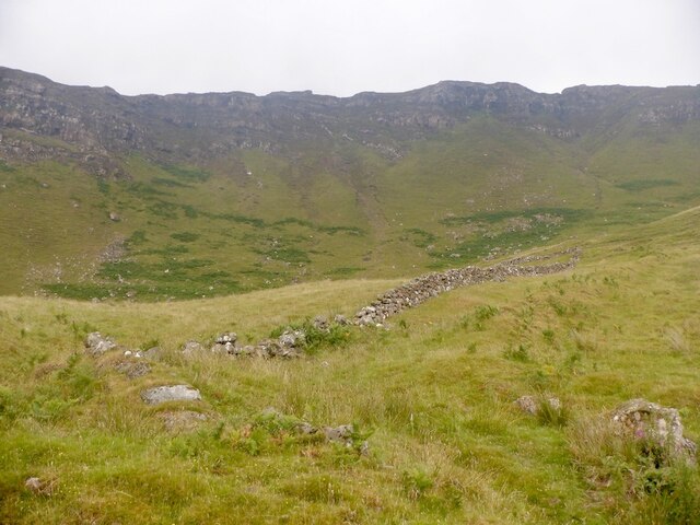
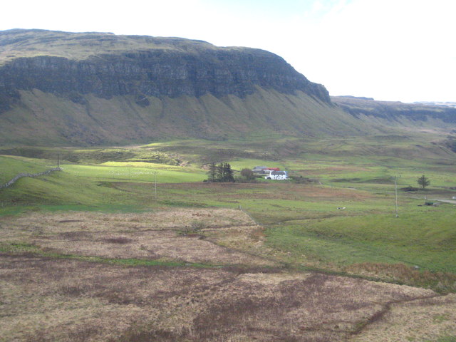
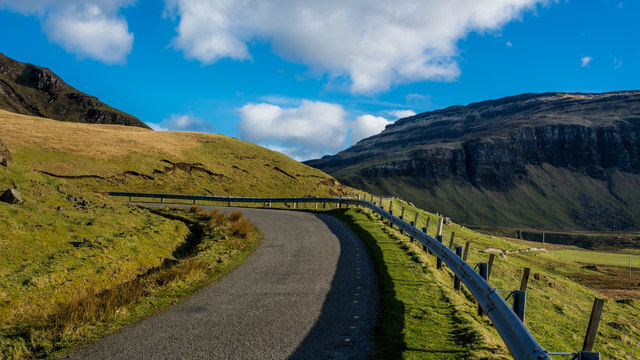
Creag a' Ghaill, located in Argyllshire, Scotland, is a prominent cliff or slope that offers breathtaking views and is well-known for its natural beauty. Rising majestically to an impressive height, this geological formation is a popular destination for nature enthusiasts and hikers alike.

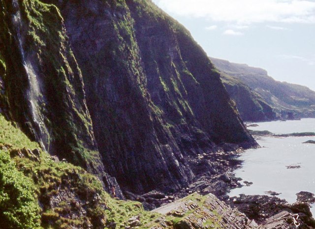
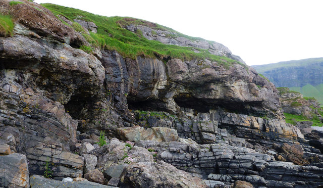
The cliff face of Creag a' Ghaill showcases a rugged and dramatic landscape, characterized by steep inclines and jagged rock formations. The cliff is primarily composed of ancient sandstone, which has been sculpted by the forces of weathering and erosion over millions of years. This erosion has resulted in the creation of deep crevices and fissures, adding to the allure and intrigue of the site.

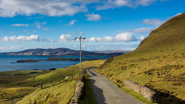
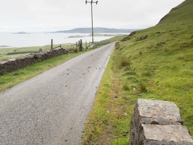
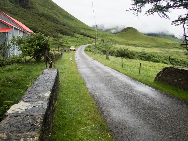
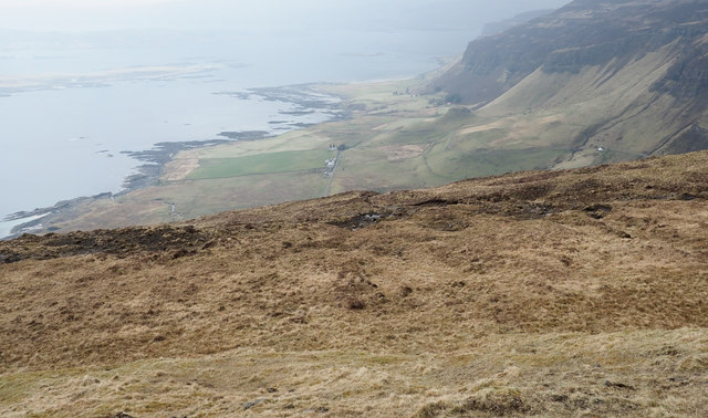
The cliff's location provides visitors with stunning vistas of the surrounding countryside, including panoramic views of rolling hills, lush forests, and picturesque lochs. The elevated vantage point offers a unique perspective of the natural wonders of Argyllshire, making it a favored spot for photography enthusiasts.

Creag a' Ghaill is also home to a diverse array of flora and fauna, providing a habitat for various species of birds, mammals, and plant life. This makes it an ideal location for wildlife observation and nature walks, allowing visitors to immerse themselves in the rich biodiversity of the region.

Overall, Creag a' Ghaill is a captivating destination that showcases the raw beauty of Scotland's natural landscapes. Whether it's the awe-inspiring views, the geological wonders, or the abundant wildlife, this cliff or slope in Argyllshire is a must-visit for those seeking an authentic and unforgettable experience in the Scottish Highlands.

If you have any feedback on the listing, please let us know in the comments section below.

Creag a' Ghaill Images

Images are sourced within 2km of 56.412711/-6.1417344 or Grid Reference NM4432. Thanks to Geograph Open Source API. All images are credited.

Igneous escarpment above Balmeanach Tertiary lava flows dominate the view but there are surviving sedimentary rocks, including chalk, here from before the volcanoes, this has led to good farmland along the coast and on Inch Kenneth.
Igneous escarpment above Balmeanach
Tertiary lava flows dominate the view but there are surviving sedimentary rocks, including chalk, here from before the volcanoes, this has led to good farmland along the coast and on Inch Kenneth.
Marshy ground below the B8035 near An Sithean Looking towards a farmstead at Balmeanach in square <a href="https://www.geograph.org.uk/gridref/NM4433">NM4433</a>.
Marshy ground below the B8035 near An Sithean
Looking towards a farmstead at Balmeanach in square NM4433.
Gribun cattle Cattle around a ring-feeder on ground below the B8035 at Gribun, Mull. Inch Kenneth island is across the water and Little Colonsay further off to the left.
Gribun cattle
Cattle around a ring-feeder on ground below the B8035 at Gribun, Mull. Inch Kenneth island is across the water and Little Colonsay further off to the left.
Sea cliffs at Mackinnon's Cave
Start of the downhill section of the B8073 to Loch na Keal
In the hairpins on the B8035
Coastal road on Mull There are a number of images taken along the Allt na Teangaidh, eg <a href="https://www.geograph.org.uk/photo/4388391">NM4532 : Allt na Teangaidh</a>. This bridge, with a rivet benchmark <a href="https://www.geograph.org.uk/photo/5461761">NM4532 : Benchmark on a bridge parapet</a> at the end of the parapet, is over an unnamed tributary flowing from the cliffs of A Mhaol. The view is along the A8035 (which runs out of the square in about 150m) to the small island of Inch Kenneth and the larger island of Ulva beyond.
Coastal road on Mull
There are a number of images taken along the Allt na Teangaidh, eg NM4532 : Allt na Teangaidh. This bridge, with a rivet benchmark NM4532 : Benchmark on a bridge parapet at the end of the parapet, is over an unnamed tributary flowing from the cliffs of A Mhaol. The view is along the A8035 (which runs out of the square in about 150m) to the small island of Inch Kenneth and the larger island of Ulva beyond.
Benchmark on a bridge parapet The OS description is NBM RIVET NE PARA BR NW END. The bridge parapet and the view from it are shown in <a href="https://www.geograph.org.uk/photo/5461757">NM4532 : Coastal road on Mull</a>.
Benchmark on a bridge parapet
The OS description is NBM RIVET NE PARA BR NW END. The bridge parapet and the view from it are shown in NM4532 : Coastal road on Mull.
On the bridge over the Alltan na Caillich This is looking SE to the fantastic scenery (partly obscured by mist) that overlooks the A8035 and the coast of this part of Mull. The red-roofed house features in <a href="https://www.geograph.org.uk/photo/2944007">NM4534 : Corrugated House by the B8035</a> and  <a href="https://www.geograph.org.uk/photo/3377713">NM4534 : Corrugated iron house at Balnahard</a>. There is a rivet benchmark <a href="https://www.geograph.org.uk/photo/5461779">NM4534 : A well indicated benchmark</a> on the right hand edge of the stone with the large patch of whitish lichen on its left hand edge.
On the bridge over the Alltan na Caillich
This is looking SE to the fantastic scenery (partly obscured by mist) that overlooks the A8035 and the coast of this part of Mull. The red-roofed house features in NM4534 : Corrugated House by the B8035 and NM4534 : Corrugated iron house at Balnahard. There is a rivet benchmark NM4534 : A well indicated benchmark on the right hand edge of the stone with the large patch of whitish lichen on its left hand edge.
Buried landscape on the Gribun coast In Scotland where one is so used to seeing younger rocks thrust over older ones by the dramatic (if long drawn out) collision of continents, it's good to find a classic unconformity where the younger rocks (in this case Triassic conglomerates) were laid down over the top of an existing, ancient landscape. The lower rocks (grey, layered, fine-grained) are Psammites of the Moine Series - ancient impure sandstones metamorphosed by heat and pressure, then raised to the surface and eroded. They formed shoreline rocks as the sea covered them and deposited sand and pebbles which, with deeper burial, became the conglomerate rock you see above the eroded caves and below the grass. The uneven boundary between the two rock types shows the shape of the rocky shore before its burial. More recently again, in Tertiary times, as Europe and North America started to separate, the whole lot was buried deeper by lava flows.  Erosion works constantly, and here they all are again exposed to view as the sea cuts away the land, leaving scattered boulders not only of the conglomerate and the psammite, but also of the basalt from the cliffs seen in the distance.
Buried landscape on the Gribun coast
In Scotland where one is so used to seeing younger rocks thrust over older ones by the dramatic (if long drawn out) collision of continents, it's good to find a classic unconformity where the younger rocks (in this case Triassic conglomerates) were laid down over the top of an existing, ancient landscape. The lower rocks (grey, layered, fine-grained) are Psammites of the Moine Series - ancient impure sandstones metamorphosed by heat and pressure, then raised to the surface and eroded. They formed shoreline rocks as the sea covered them and deposited sand and pebbles which, with deeper burial, became the conglomerate rock you see above the eroded caves and below the grass. The uneven boundary between the two rock types shows the shape of the rocky shore before its burial. More recently again, in Tertiary times, as Europe and North America started to separate, the whole lot was buried deeper by lava flows. Erosion works constantly, and here they all are again exposed to view as the sea cuts away the land, leaving scattered boulders not only of the conglomerate and the psammite, but also of the basalt from the cliffs seen in the distance.
Balmeanach Farm Creag a' Ghaill is beyond the farm.
Balmeanach Farm
Creag a' Ghaill is beyond the farm.
Small cove near Mackinnon's Cave Apparently unnamed cove, SW of the cave and below the west end of Creag a' Ghaill. The Allt an Ath Dheirg enters the sea here.
Out to sea are Erisgeir (centre) with Staffa and the Dutchman's Cap aligned (centre right).
Small cove near Mackinnon's Cave
Apparently unnamed cove, SW of the cave and below the west end of Creag a' Ghaill. The Allt an Ath Dheirg enters the sea here. Out to sea are Erisgeir (centre) with Staffa and the Dutchman's Cap aligned (centre right).
Allt na Teangaidh The Allt na Teangaidh close to the B8035 flowing north, soon to enter a steepening slot along its course, passing the eastern end of the rocks of Creag a' Ghaill before entering Loch na Keal.
Allt na Teangaidh
The Allt na Teangaidh close to the B8035 flowing north, soon to enter a steepening slot along its course, passing the eastern end of the rocks of Creag a' Ghaill before entering Loch na Keal.
Moorland drained by Allt na Teangaidh The minor watercourse in the foreground is a tributary to the  Allt na Teangaidh which crosses the wider space beyond.
The tiered rocks are on the north-east face of Beinn na h-Iolaire.
Moorland drained by Allt na Teangaidh
The minor watercourse in the foreground is a tributary to the Allt na Teangaidh which crosses the wider space beyond. The tiered rocks are on the north-east face of Beinn na h-Iolaire.
Gravelly material on north side of Beinn na h-Iolaire There are extensive areas of this granular, earthy/gravelly material on Beinn na h-Iolaire. Similar areas are found on nearby hills to the south, Beinn na Srèine and Maol Mhèadhonach. In this area there are 'pegs', (tubes actually), set into the surface of the material; it's likely they were placed to assess the rate of erosion of the surface which must occur by wind and water. For a similar example (without tubes), see <a title="https://www.geograph.org.uk/photo/5742073" href="https://www.geograph.org.uk/photo/5742073">Link</a> .
Gravelly material on north side of Beinn na h-Iolaire
There are extensive areas of this granular, earthy/gravelly material on Beinn na h-Iolaire. Similar areas are found on nearby hills to the south, Beinn na Srèine and Maol Mhèadhonach. In this area there are 'pegs', (tubes actually), set into the surface of the material; it's likely they were placed to assess the rate of erosion of the surface which must occur by wind and water. For a similar example (without tubes), see Link .
Moorland on Beinn na h-Iolaire The moorland is on the broad, north-west ridge of Beinn na h-Iolaire.
Beyond are the hills Fionna Mhàm, nearer the camera, and Creach-Bheinn.
Moorland on Beinn na h-Iolaire
The moorland is on the broad, north-west ridge of Beinn na h-Iolaire. Beyond are the hills Fionna Mhàm, nearer the camera, and Creach-Bheinn.
Slope descending towards Creag a' Ghaill There's little clue in the image but just beyond the limit of the foreground slope there's terrific verticality in the form of a high cliff - Creag a' Ghaill; Alex Nelson's photograph shows it well - <a title="https://www.geograph.org.uk/photo/521227" href="https://www.geograph.org.uk/photo/521227">Link</a>.
The sea below is Loch na Keal with the island, Inch Kenneth seen dimly offshore.
Slope descending towards Creag a' Ghaill
There's little clue in the image but just beyond the limit of the foreground slope there's terrific verticality in the form of a high cliff - Creag a' Ghaill; Alex Nelson's photograph shows it well - Link. The sea below is Loch na Keal with the island, Inch Kenneth seen dimly offshore.
B8035 crossing slope above Balmeanach Balmeanach is an area of farmed land close to Loch na Keal; it lies below the slope largely out of view in the image. The B8035 continues around the corner climbing to cross a pass before descending to the shore of Loch Scridain.
B8035 crossing slope above Balmeanach
Balmeanach is an area of farmed land close to Loch na Keal; it lies below the slope largely out of view in the image. The B8035 continues around the corner climbing to cross a pass before descending to the shore of Loch Scridain.
Show me another place!

Creag a' Ghaill is located at Grid Ref: NM4432 (Lat: 56.412711, Lng: -6.1417344)

Unitary Authority: Argyll and Bute

Police Authority: Argyll and West Dunbartonshire

What 3 Words

///shaky.logbook.readings. Near Salen, Argyll & Bute

Related Wikis

Ardmeanach

Ardmeanach in modern times refers to a peninsula on the Isle of Mull. It is the middle one out of three westward-facing peninsulas on the island, and the...

St Kenneth's Chapel

St. Kenneth's Chapel is a ruined chapel on Inch Kenneth Island, Parish of Kilfinichen and Kilvickeon, Isle of Mull, Argyll and Bute, Scotland. It dates...

Inch Kenneth

Inch Kenneth (Scottish Gaelic: Innis Choinnich) is a small grassy island off the west coast of the Isle of Mull, in Scotland. It is at the entrance of...

Samalan Island

Samalan Island is a small island, just off the Isle of Mull at the mouth of Loch na Keal in the Inner Hebrides, Scotland. To its south west is the island...

Have you been to Creag a' Ghaill?

Leave your review of Creag a' Ghaill below (or comments, questions and feedback).