Creag a' Chapaill

Cliff, Slope in Inverness-shire

Scotland

Creag a' Chapaill

Portable radio operation from NG 31 Looking North to the Cullin Hills from NG3917. In the foreground radio amateur activating the remote 10km x 10km square NG31 for the Worked All Britain Award Scheme.
Portable radio operation from NG 31 Credit: Barrie Eyre

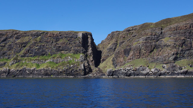
Creag a' Chapaill is a prominent cliff located in Inverness-shire, Scotland. It is situated near the village of Inverfarigaig, overlooking the famous Loch Ness. The name Creag a' Chapaill translates to "The Horse's Rock" in English.

The cliff is characterized by its steep slope and rugged terrain, making it a popular destination for outdoor enthusiasts and hikers looking for a challenging climb. The rock formations on the cliff provide a stunning backdrop against the scenic views of Loch Ness and the surrounding countryside.

Creag a' Chapaill is home to a variety of wildlife, including birds of prey such as eagles and falcons, making it a great spot for birdwatching. The area is also rich in flora, with heather, mosses, and lichens covering the rocky surfaces.

Visitors to Creag a' Chapaill can enjoy breathtaking views of Loch Ness and the surrounding mountains from the top of the cliff. The rugged beauty of this natural landmark makes it a must-visit destination for nature lovers and outdoor adventurers in Inverness-shire.

If you have any feedback on the listing, please let us know in the comments section below.

Creag a' Chapaill Images

Images are sourced within 2km of 57.161718/-6.3017563 or Grid Reference NG4016. Thanks to Geograph Open Source API. All images are credited.

Portable radio operation from NG 31 Looking North to the Cullin Hills from NG3917. In the foreground radio amateur activating the remote 10km x 10km square NG31 for the Worked All Britain Award Scheme.
Portable radio operation from NG 31
Looking North to the Cullin Hills from NG3917. In the foreground radio amateur activating the remote 10km x 10km square NG31 for the Worked All Britain Award Scheme.
Dunan 18th-Century Township See <span class="nowrap"><a title="http://canmore.org.uk/site/11224" rel="nofollow ugc noopener" href="http://canmore.org.uk/site/11224">Link</a><img style="margin-left:2px;" alt="External link" title="External link - shift click to open in new window" src="https://s1.geograph.org.uk/img/external.png" width="10" height="10"/></span> for more info.
Dunan 18th-Century Township
See LinkExternal link for more info.
A Lamb's Sheltered Haven
Cliffs at Slochd Dubh Slochd Dubh (trench) cuts across the Rubh an Dunain peninsula.
Cliffs at Slochd Dubh
Slochd Dubh (trench) cuts across the Rubh an Dunain peninsula.
Unnamed lochan below Creag Mhór The Cuillin is in the background.
Unnamed lochan below Creag Mhór
The Cuillin is in the background.
Creag Mhór Loch Brittle is on the left, the Cuillin is in the background.
Creag Mhór
Loch Brittle is on the left, the Cuillin is in the background.
Creag Mhór The south end of the crag. Looking across Loch Brittle.
Creag Mhór
The south end of the crag. Looking across Loch Brittle.
Rubha na Creige Moire, Loch Brittle Late afternoon light over the point and Cuillin Sound to the Isle of Canna
Rubha na Creige Moire, Loch Brittle
Late afternoon light over the point and Cuillin Sound to the Isle of Canna
Ruined farmstead in Slochd Dubh The ruin of a house with barn just below it. Across the moor, below the craggy outcrops, the long wall across Slochd Dubh can be made out. On the distant horizon are the islands of Rum and Canna.
Ruined farmstead in Slochd Dubh
The ruin of a house with barn just below it. Across the moor, below the craggy outcrops, the long wall across Slochd Dubh can be made out. On the distant horizon are the islands of Rum and Canna.
Built with care The solid heavy stones of this ruined farmstead in Slochd Dubh are a credit to the hands that put them in place, maybe 250 years ago.
Built with care
The solid heavy stones of this ruined farmstead in Slochd Dubh are a credit to the hands that put them in place, maybe 250 years ago.
Ruined farmstead in Slochd Dubh The ruin stands alone amid grassland no longer cared for or cultivated.
Ruined farmstead in Slochd Dubh
The ruin stands alone amid grassland no longer cared for or cultivated.
A long wall The people who once farmed here were not afraid of building with stone. This wall, now tumbled in places, extends right across the peninsula which ends at Rubha an Dùnain.
A long wall
The people who once farmed here were not afraid of building with stone. This wall, now tumbled in places, extends right across the peninsula which ends at Rubha an Dùnain.
Former farmland in Slochd Dubh The wall in the foreground extends right across the peninsula. There are also a few wooden fence posts here - remains of a boundary younger than the wall. The flatter land is now boggy, while bracken grows on the slopes. The distant Cuillin peaks peep over the hill.
Former farmland in Slochd Dubh
The wall in the foreground extends right across the peninsula. There are also a few wooden fence posts here - remains of a boundary younger than the wall. The flatter land is now boggy, while bracken grows on the slopes. The distant Cuillin peaks peep over the hill.
End of the track A stony track leads to here from the bottom of Glen Brittle. At about this point, the track vanishes. Just beyond, and not visible in this picture, lie the ruins  of the township of Dunan - a community of at least 22 houses. The residents were moved from here in the 19th century. On the horizon is the island of Canna, with part of Rum on the left.
End of the track
A stony track leads to here from the bottom of Glen Brittle. At about this point, the track vanishes. Just beyond, and not visible in this picture, lie the ruins of the township of Dunan - a community of at least 22 houses. The residents were moved from here in the 19th century. On the horizon is the island of Canna, with part of Rum on the left.
Ruin in Dunan This is Rudh an Dunain, the largest house, and best preserved ruin, in the ruined township of Dunan. The township was home to the MacAskills, who probably came to Skye from Ireland in about 1170AD, and lived here until the mid 18th century. More information: Highland Council, Historic Environment Record: <span class="nowrap"><a title="http://her.highland.gov.uk/SingleResult.aspx?uid=MHG5079" rel="nofollow ugc noopener" href="http://her.highland.gov.uk/SingleResult.aspx?uid=MHG5079">Link</a><img style="margin-left:2px;" alt="External link" title="External link - shift click to open in new window" src="https://s1.geograph.org.uk/img/external.png" width="10" height="10"/></span>. 
On the horizon is the island of Rum.
Ruin in Dunan
This is Rudh an Dunain, the largest house, and best preserved ruin, in the ruined township of Dunan. The township was home to the MacAskills, who probably came to Skye from Ireland in about 1170AD, and lived here until the mid 18th century. More information: Highland Council, Historic Environment Record: LinkExternal link. On the horizon is the island of Rum.
Ruin in Dunan This is the rounded end of the largest house in Dunan. The other end of the building was probably also originally rounded, but was rebuilt in the 16th/17th centuries to create a gable end wall and chimney. On the left is an outbuilding. There are remains of at least 22 houses in Dunan, which was home to the MacAskills from about 1170AD until the mid 18th century.
Ruin in Dunan
This is the rounded end of the largest house in Dunan. The other end of the building was probably also originally rounded, but was rebuilt in the 16th/17th centuries to create a gable end wall and chimney. On the left is an outbuilding. There are remains of at least 22 houses in Dunan, which was home to the MacAskills from about 1170AD until the mid 18th century.
Ruin in Dunan This is the largest and best preserved of the ruins in Dunan. The building possibly dates back to about 1200AD. There are remains of over 22 houses in Dunan, which was home to the MacAskills until the mid 18th Century.
Ruin in Dunan
This is the largest and best preserved of the ruins in Dunan. The building possibly dates back to about 1200AD. There are remains of over 22 houses in Dunan, which was home to the MacAskills until the mid 18th Century.
Detail of ruin in Dunan This is part of the gable end wall of the largest of the ruins in Dunan. This wall was probably built in the 16th/17th centuries, when a chimney was added to the house. This shot shows how the walls are constructed using many flat stones between the larger squared stones, which is a building style I have not come across before on Skye.
Detail of ruin in Dunan
This is part of the gable end wall of the largest of the ruins in Dunan. This wall was probably built in the 16th/17th centuries, when a chimney was added to the house. This shot shows how the walls are constructed using many flat stones between the larger squared stones, which is a building style I have not come across before on Skye.
Show me another place!

Creag a' Chapaill is located at Grid Ref: NG4016 (Lat: 57.161718, Lng: -6.3017563)

Unitary Authority: Highland

Police Authority: Highlands and Islands

What 3 Words

///flagging.marzipan.medium. Near Elgol, Highland

Nearby Locations

Creag a' Chapaill

Related Wikis

Rubha an Dùnain

Rubha an Dùnain or Rubh' an Dùnain (Scottish Gaelic pronunciation: [ᵲu(.ə) ən t̪uːnən]) is an uninhabited peninsula to the south of the Cuillin hills on...

Loch Brittle

Loch Brittle is a sea loch on the southwest coast of Skye in Scotland. A sandy beach separates Glen Brittle from Loch Brittle. The land to the sides of...

Soay, Inner Hebrides

Soay (Scottish Gaelic: Sòdhaigh, pronounced [ˈs̪ɔː.aj]) is an island just off the coast of Skye, in the Inner Hebrides of Scotland. == Geography == Soay...

Bualintur

Bualintur (Scottish Gaelic: Buaile an Todhair) is a remote township, which lies at the head of Loch Brittle on the island of Skye in the Highlands of...

Nearby Amenities

Located within 500m of 57.161718,-6.3017563
Source: PGS
Lat/Long: 57.1604198/-6.3094816
Source: PGS
Lat/Long: 57.1602046/-6.309267
Source: PGS
Lat/Long: 57.1601146/-6.3082768
Source: PGS
Lat/Long: 57.160335/-6.3079108
Source: PGS
Lat/Long: 57.1607404/-6.3059647
Source: PGS
Lat/Long: 57.1612107/-6.3055304
Source: PGS
Lat/Long: 57.1614264/-6.3052976
Source: PGS
Lat/Long: 57.1614726/-6.303183
Created By: dmgroom_coastlines
Source: PGS
Lat/Long: 57.16157/-6.30215
Created By: dmgroom_coastlines
Source: PGS
Lat/Long: 57.16155/-6.30122
Created By: dmgroom_coastlines
Source: PGS
Lat/Long: 57.16153/-6.30028
Created By: dmgroom_coastlines
Source: PGS
Lat/Long: 57.16165/-6.30003
Source: PGS
Lat/Long: 57.1619093/-6.2995145
Created By: dmgroom_coastlines
Source: PGS
Lat/Long: 57.16227/-6.2988
Created By: dmgroom_coastlines
Source: PGS
Lat/Long: 57.1625/-6.29785
Created By: dmgroom_coastlines
Source: PGS
Lat/Long: 57.16262/-6.29761
Source: PGS
Lat/Long: 57.1630797/-6.2970304
Source: PGS
Lat/Long: 57.1632415/-6.2959096
Source: PGS
Lat/Long: 57.1633299/-6.2949812
Created By: dmgroom_coastlines
Source: PGS
Lat/Long: 57.16345/-6.29448
Ford: yes
Lat/Long: 57.1644754/-6.3017295
Ford: yes
Lat/Long: 57.166097/-6.300479
Dun
Castle Type: defensive
Historic: castle
Lat/Long: 57.1602099/-6.3087155
Natural: cave_entrance
Lat/Long: 57.1632816/-6.3029753
Historic: ruins
Lat/Long: 57.1660457/-6.3001264
Source: PGS
Lat/Long: 57.161323/-6.3032482
Source: PGS
Lat/Long: 57.1614726/-6.303183
Source: PGS
Lat/Long: 57.1614726/-6.303183
Source: PGS
Lat/Long: 57.16131/-6.3022075
Source: PGS
Lat/Long: 57.16157/-6.30215
Source: PGS
Lat/Long: 57.1612751/-6.3009951
Source: PGS
Lat/Long: 57.16155/-6.30122
Source: PGS
Lat/Long: 57.1614275/-6.3001739
Source: PGS
Lat/Long: 57.16153/-6.30028
Source: PGS
Lat/Long: 57.1621722/-6.297835
Source: PGS
Lat/Long: 57.16227/-6.2988
Source: PGS
Lat/Long: 57.16262/-6.29761
Source: PGS
Lat/Long: 57.1624747/-6.2970948
Source: PGS
Lat/Long: 57.1633299/-6.2949812
Source: PGS
Lat/Long: 57.16345/-6.29448
Source: PGS
Lat/Long: 57.1628983/-6.2961564
Rudh an Dunain
Place: locality
Lat/Long: 57.1648891/-6.2997805
The data included in this document is from www.openstreetmap.org. The data is made available under ODbL.

Have you been to Creag a' Chapaill?

Leave your review of Creag a' Chapaill below (or comments, questions and feedback).