Ardensawah Cliff

Cliff, Slope in Cornwall

England

Ardensawah Cliff

Lower Bosistow Cliff path approaching Nanjizal Beach
Lower Bosistow Cliff path approaching Nanjizal Beach Credit: Tom Page

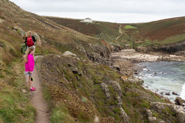
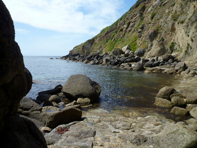
Ardensawah Cliff is an impressive coastal feature located in Cornwall, England. Situated near the small village of Ardensawah, this cliff offers breathtaking views of the Atlantic Ocean and is a popular destination for hikers, nature enthusiasts, and tourists alike.

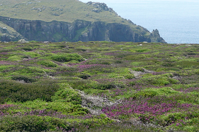
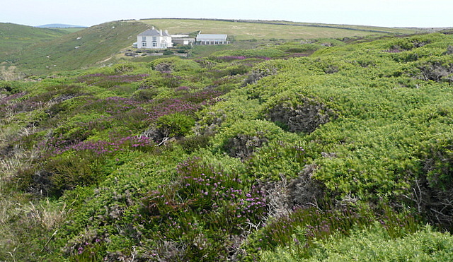
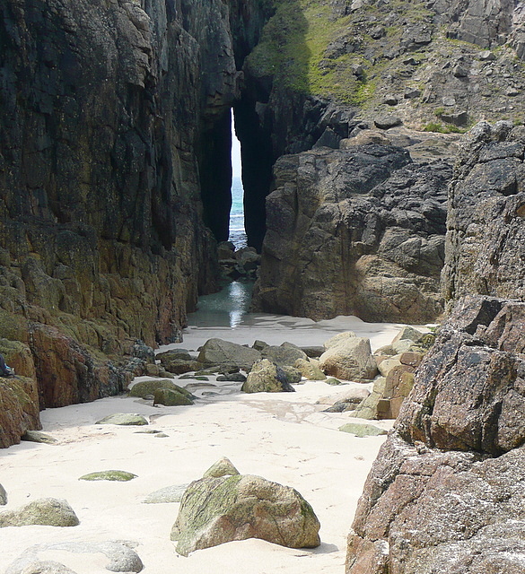
With its towering height and sheer drop, Ardensawah Cliff presents a striking natural landscape. The cliff is composed of rugged, weathered rock formations that have been shaped by centuries of erosion. The exposed layers of sedimentary rock provide a fascinating glimpse into the area's geological history.

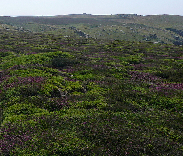
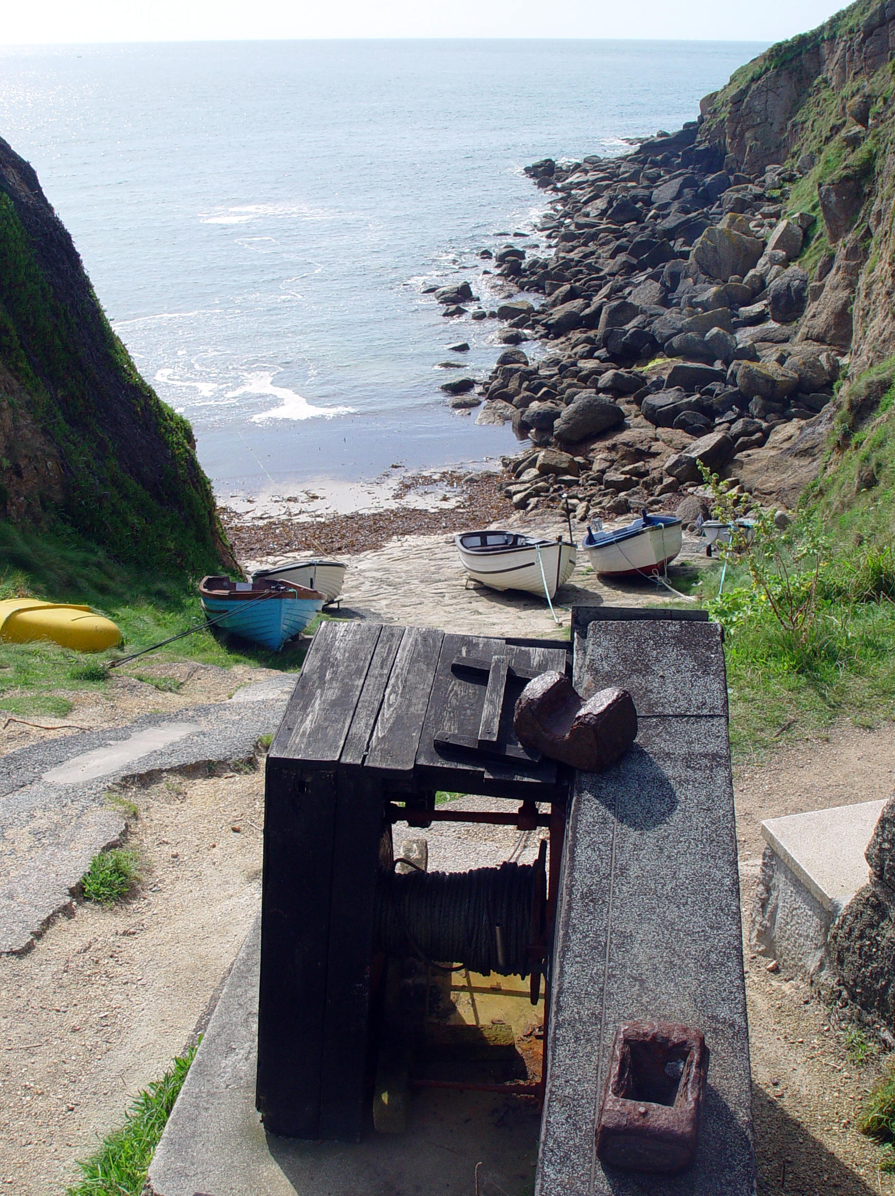
The cliff face is covered in lush vegetation, with hardy grasses, shrubs, and wildflowers clinging to the rocky surface. This diverse flora supports a variety of wildlife, including nesting seabirds, such as gulls and fulmars, which can be observed soaring above the cliff.

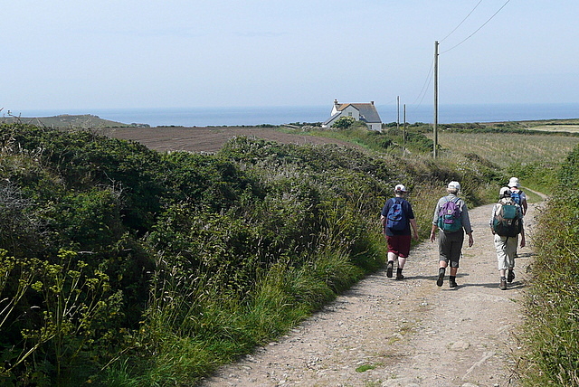
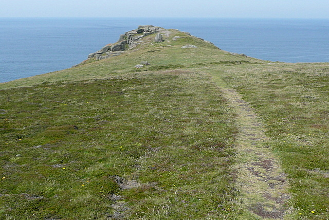
Visitors to Ardensawah Cliff can access it via a well-maintained footpath that winds its way along the cliff edge. This path offers stunning panoramic views of the surrounding coastline, with its dramatic cliffs, sandy beaches, and crashing waves.

It is advisable to exercise caution when exploring Ardensawah Cliff, as the terrain can be treacherous, especially during inclement weather. The cliffs are subject to erosion and occasional landslides, so it is important to stay on designated paths and heed any safety warnings.

Ardensawah Cliff is not only a picturesque destination but also serves as an important geological and ecological site in Cornwall. Its unique blend of natural beauty and scientific significance make it a must-visit location for anyone exploring the region.

If you have any feedback on the listing, please let us know in the comments section below.

Ardensawah Cliff Images

Images are sourced within 2km of 50.045351/-5.6869071 or Grid Reference SW3622. Thanks to Geograph Open Source API. All images are credited.

Lower Bosistow Cliff path approaching Nanjizal Beach
Old Wayside Cross towards Ardensawah in St Levan parish Ardensawah or Ardensaweth Cross, the old head and neck of a wayside cross. Set beside a stone stile on a footpath northwest of St Levan church in St Levan parish. Grade II Listed <span class="nowrap"><a title="https://historicengland.org.uk/listing/the-list/list-entry/1146492" rel="nofollow ugc noopener" href="https://historicengland.org.uk/listing/the-list/list-entry/1146492">Link</a><img style="margin-left:2px;" alt="External link" title="External link - shift click to open in new window" src="https://s1.geograph.org.uk/img/external.png" width="10" height="10"/></span>. See also <span class="nowrap"><a title="http://www.flickr.com/photos/ocifant/412959521" rel="nofollow ugc noopener" href="http://www.flickr.com/photos/ocifant/412959521">Link</a><img style="margin-left:2px;" alt="External link" title="External link - shift click to open in new window" src="https://s1.geograph.org.uk/img/external.png" width="10" height="10"/></span>.

Milestone Society National ID: CWPW_SLE01
Old Wayside Cross towards Ardensawah in St Levan parish
Ardensawah or Ardensaweth Cross, the old head and neck of a wayside cross. Set beside a stone stile on a footpath northwest of St Levan church in St Levan parish. Grade II Listed LinkExternal link. See also LinkExternal link. Milestone Society National ID: CWPW_SLE01
The B3315 at Polgigga village sign
Polgigga village pond
Milestone on the bend at Polgigga On the B3315, which runs from Newlyn to Land's End.
Milestone on the bend at Polgigga
On the B3315, which runs from Newlyn to Land's End.
The view from the porch at St Levan Church Looking out into the churchyard. The St Levan Stone <a href="https://www.geograph.org.uk/photo/1331315">SW3822 : The St Levan Stone</a> is just out of sight to the left of the path.
The view from the porch at St Levan Church
Looking out into the churchyard. The St Levan Stone SW3822 : The St Levan Stone is just out of sight to the left of the path.
The altar in St Levan Church Seen on the occasion of the church's 2011 flower festival - the theme was 'Songs from the Shows' and the beautiful display on the altar takes as its theme 'Jesus Christ Superstar'.
The altar in St Levan Church
Seen on the occasion of the church's 2011 flower festival - the theme was 'Songs from the Shows' and the beautiful display on the altar takes as its theme 'Jesus Christ Superstar'.
Shoreline at Porthgwarra, reached through the cliff tunnel
Footpath west of Polgigga A group of walkers enjoys the straight, level and tarmaced sufrace of this footpath west of Polgigga, that leads towards Bosistow then Mill Bay.
Footpath west of Polgigga
A group of walkers enjoys the straight, level and tarmaced sufrace of this footpath west of Polgigga, that leads towards Bosistow then Mill Bay.
Lower Bosistow A lovely Georgian farmhouse on the way to Mill Bay.
Lower Bosistow
A lovely Georgian farmhouse on the way to Mill Bay.
Towards Bosistow Cliffs A group of walkers descends the track, a bridleway, from Higher Bosistow towards the coast at Carn Lês Boel.
Towards Bosistow Cliffs
A group of walkers descends the track, a bridleway, from Higher Bosistow towards the coast at Carn Lês Boel.
Heather on Higher Bosistow Cliffs There are two well-defined tracks across the heather, the coastal path and an inland route towards Higher Bosistow.  This is the area of heather moorland in between.
Heather on Higher Bosistow Cliffs
There are two well-defined tracks across the heather, the coastal path and an inland route towards Higher Bosistow. This is the area of heather moorland in between.
Higher Bosistow Cliffs There is a stretch of heather moorland above the coastal path, which runs below the first horizon.
Higher Bosistow Cliffs
There is a stretch of heather moorland above the coastal path, which runs below the first horizon.
Towards Carn Lês Boel This is an ancient promontory name, at a location where there used to be a fort, probably Iron Age.  The coastal path runs just in front of us, having come down the bridleway from Higher Bosistow.
Towards Carn Lês Boel
This is an ancient promontory name, at a location where there used to be a fort, probably Iron Age. The coastal path runs just in front of us, having come down the bridleway from Higher Bosistow.
Mill Bay or Nanjizal This view from High Bosistow Cliff shows most of Mill Bay and the north-western part of the square, with the coastal path continuing over Trevilley Cliff beyond towards Lands End.  The buildings at Lands End <a href="https://www.geograph.org.uk/gridref/SW3424">SW3424</a> can be seen on the horizon.  The alternative name for Mill Bay, Nanjizal, is also given to the nearby house.  I cannot find the origin of the name though.
Mill Bay or Nanjizal
This view from High Bosistow Cliff shows most of Mill Bay and the north-western part of the square, with the coastal path continuing over Trevilley Cliff beyond towards Lands End. The buildings at Lands End SW3424 can be seen on the horizon. The alternative name for Mill Bay, Nanjizal, is also given to the nearby house. I cannot find the origin of the name though.
Nanjizal Holiday cottage with a view.  This is Nanjizal, a remote house with a stunning position above Mill Bay.
Nanjizal
Holiday cottage with a view. This is Nanjizal, a remote house with a stunning position above Mill Bay.
The Song of the Sea That is the name of this cove, adjacent to Mill Bay or Nanjizal beach, where the sea has cut through the rock to form a narrow passage.  

Someone who has been there writes on Wikipedia "Inside the cove are large rockpools with many types of sea anemones and seaweeds, although the rocks are very slippery and the cove dark and damp. Several of the rocks appear to be covered with a purple substance."
The Song of the Sea
That is the name of this cove, adjacent to Mill Bay or Nanjizal beach, where the sea has cut through the rock to form a narrow passage. Someone who has been there writes on Wikipedia "Inside the cove are large rockpools with many types of sea anemones and seaweeds, although the rocks are very slippery and the cove dark and damp. Several of the rocks appear to be covered with a purple substance."
Mill Bay or Nanjizal A wonderfully secluded beach.  When the weather is fine this is a great place to be, and to stay being.  But it faces due west, so when those Atlantic storms roll in it is probably not so pleasant.
Mill Bay or Nanjizal
A wonderfully secluded beach. When the weather is fine this is a great place to be, and to stay being. But it faces due west, so when those Atlantic storms roll in it is probably not so pleasant.
Show me another place!

Ardensawah Cliff is located at Grid Ref: SW3622 (Lat: 50.045351, Lng: -5.6869071)

Unitary Authority: Cornwall

Police Authority: Devon and Cornwall

What 3 Words

///topics.zooms.manhole. Near Sennen, Cornwall

Related Wikis

Porthgwarra to Pordenack Point

Porthgwarra to Pordenack Point is a coastal Site of Special Scientific Interest (SSSI) in west Cornwall, England, noted for its biological characteristics...

Nanjizal

Nanjizal (Cornish: Porth Nansusel, meaning "cove of the howling valley"), also known as Mill Bay, is a beach and cove in the civil parish of St Levan,...

Gwennap Head

Gwennap Head (Cornish: Toll Pedn Pennwydh, meaning holed head of Penwith; grid reference SW3621) is a headland on the south coast of the Penwith peninsula...

Porthgwarra

Porthgwarra (Cornish: Porth Gorwedhow, meaning very wooded cove) is a small coastal village in the civil parish of St Levan, Cornwall, England, United...

Nearby Amenities

Located within 500m of 50.045351,-5.6869071
Folly Cove
Is In: Cornwall, England, UK
Place: locality
Source: OS 1:25k
Lat/Long: 50.0426048/-5.687733
Black Carn
Is In: Cornwall, England, UK
Place: locality
Source: OS 1:25k
Lat/Long: 50.0423844/-5.6863168
Ardensaweth Cliff
Is In: Cornwall, England, UK
Place: locality
Source: OS 1:25k
Lat/Long: 50.0457191/-5.688763
Carn Trevean
Is In: Cornwall, England, UK
Place: locality
Source: OS 1:25k
Lat/Long: 50.047538/-5.6881192
Carn Barra
Is In: Cornwall, England, UK
Place: locality
Source: OS 1:25k
Lat/Long: 50.044975/-5.6899217
Pendower Cove
Is In: Cornwall, England, UK
Place: locality
Source: OS 1:25k
Lat/Long: 50.0481994/-5.6884197
Zawn Kelly
Is In: Cornwall, England, UK
Place: locality
Source: OS 1:25k
Lat/Long: 50.0455262/-5.6895354
Barrier: kissing_gate
Foot: yes
Lat/Long: 50.042014/-5.6855627
Source: PGS
Lat/Long: 50.0480368/-5.6887073
The data included in this document is from www.openstreetmap.org. The data is made available under ODbL.

Have you been to Ardensawah Cliff?

Leave your review of Ardensawah Cliff below (or comments, questions and feedback).