Blunts Point

Coastal Feature, Headland, Point in Durham

England

Blunts Point

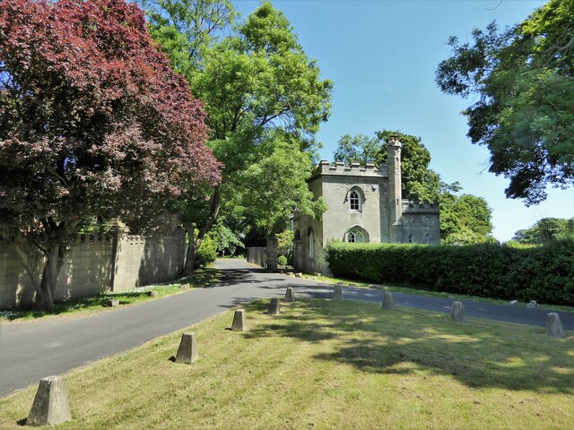
The Village, Castle Eden A quiet no through road called simply The Village leads to the parish church, an 18th century mansion called The Castle, and a handful of other houses.
Just because it has a bright red door, the nearest building looks like an old fire station, but I don't suppose it was.
The Village, Castle Eden Credit: Des Blenkinsopp

Blunts Point is a prominent coastal feature located in Durham, a county in the northeast of England. Situated along the rugged North Sea coastline, this headland juts out into the water, forming a distinct point that offers breathtaking views and unique geological formations.

This prominent headland is characterized by its towering cliffs, which rise steeply from the sea to a considerable height. The cliffs are composed of sedimentary rock layers, showcasing the geological history of the region. Blunts Point is known for its distinctive reddish-brown sandstone, which adds to its visual appeal.

The point itself is a popular destination for nature enthusiasts and hikers who are drawn to the stunning coastal scenery and the opportunity to explore the area's diverse flora and fauna. The cliffs provide nesting sites for various seabird species, including kittiwakes, fulmars, and cormorants, making it an important habitat for avian biodiversity.

Blunts Point also offers stunning panoramic views of the North Sea and the surrounding coastline, with its rugged cliffs stretching as far as the eye can see. On a clear day, visitors can even spot distant landmarks like the nearby Seaham Harbour and the iconic Whitby Abbey.

Access to Blunts Point is relatively easy, with a well-maintained footpath leading to the point from the nearest car park. However, caution is advised due to the steep cliffs and occasional strong winds. Overall, Blunts Point is a captivating coastal feature that showcases the natural beauty and geological significance of the Durham coastline.

If you have any feedback on the listing, please let us know in the comments section below.

Blunts Point Images

Images are sourced within 2km of 54.750701/-1.335378 or Grid Reference NZ4239. Thanks to Geograph Open Source API. All images are credited.

The Village, Castle Eden A quiet no through road called simply The Village leads to the parish church, an 18th century mansion called The Castle, and a handful of other houses.
Just because it has a bright red door, the nearest building looks like an old fire station, but I don't suppose it was.
The Village, Castle Eden
A quiet no through road called simply The Village leads to the parish church, an 18th century mansion called The Castle, and a handful of other houses. Just because it has a bright red door, the nearest building looks like an old fire station, but I don't suppose it was.
Castle Eden War Memorial Castle Eden's memorial is on a small triangular green by a bend in the road.
In the background past what looks like a lodge house, a road leads to an estate called Parklands.
Castle Eden War Memorial
Castle Eden's memorial is on a small triangular green by a bend in the road. In the background past what looks like a lodge house, a road leads to an estate called Parklands.
The Factory, Castle Eden A housing terrace called The Factory.
Something I found on the web about it says "The Factory is the name given to a row of houses located in Castle Eden. During the 1800s, they were used to produce rope and sails."
The Factory, Castle Eden
A housing terrace called The Factory. Something I found on the web about it says "The Factory is the name given to a row of houses located in Castle Eden. During the 1800s, they were used to produce rope and sails."
Shotton Hall, Peterlee, south frontage 18th to 19th century rebuild of earlier manor house, now used by Peterlee Town Council as offices, conference centre, function suites.
Shotton Hall, Peterlee, south frontage
18th to 19th century rebuild of earlier manor house, now used by Peterlee Town Council as offices, conference centre, function suites.
North side of Shotton Hall, Peterlee
Hesleden WMC On Front Street
Hesleden WMC
On Front Street
Cycle path following route of former railway Approaching a dangerous crossing of a track used by quarry wagons. To the left of this view is a former colliery spoil heap which is being remediated.
Cycle path following route of former railway
Approaching a dangerous crossing of a track used by quarry wagons. To the left of this view is a former colliery spoil heap which is being remediated.
Church of St James
Church of St James
West Lodge To the Castle Eden Estate
West Lodge
To the Castle Eden Estate
Co-operative Buildings, Cotsford Lane Presumably all a co-op store at one time, but now only partly retained as a co-op funeral parlour at the far end.
Co-operative Buildings, Cotsford Lane
Presumably all a co-op store at one time, but now only partly retained as a co-op funeral parlour at the far end.
Fourth Street, Horden A very short street leading to a green. In between the much longer Third and Fifth Streets.
Fourth Street, Horden
A very short street leading to a green. In between the much longer Third and Fifth Streets.
Horden, South Terrace The OS Flush Bracket G4888 is embedded into the roadside wall on the north side of the road. This is the boundary wall to Horden Catholic Social Club.
Horden, South Terrace
The OS Flush Bracket G4888 is embedded into the roadside wall on the north side of the road. This is the boundary wall to Horden Catholic Social Club.
Horden, St Mary's church The benchmark is cut into the south-west facing wall of the church.
Horden, St Mary's church
The benchmark is cut into the south-west facing wall of the church.
Horden, St Mary's church There is a benchmark cut into the south-west facing wall of the church.
Horden, St Mary's church
There is a benchmark cut into the south-west facing wall of the church.
Lee House From the roof top car park to the Wilko store at Peterlee. A typical piece of architecture for a new town in the second half of the 20th century.
Lee House
From the roof top car park to the Wilko store at Peterlee. A typical piece of architecture for a new town in the second half of the 20th century.
Peterlee Memorial Methodist Church Part of the new town
Peterlee Memorial Methodist Church
Part of the new town
The former Victoria Billiard Hall On Dene Street
The former Victoria Billiard Hall
On Dene Street
Show me another place!

Blunts Point is located at Grid Ref: NZ4239 (Lat: 54.750701, Lng: -1.335378)

Unitary Authority: County Durham

Police Authority: Durham

What 3 Words

///bought.sage.cried. Near Peterlee, Co. Durham

Nearby Locations

Sunny Blunts Blunts Point

Related Wikis

Peterlee Community Hospital

Peterlee Community Hospital is a health facility in O'Neill Drive, Peterlee, County Durham, England. It is managed by North Tees and Hartlepool NHS Foundation...

Castle Eden Dene

Castle Eden Dene is a Site of Special Scientific Interest and National Nature Reserve in the Easington district of County Durham, England. It is located...

Apollo Pavilion

The Apollo Pavilion, also known as the Pasmore Pavilion, is a piece of public art in the new town of Peterlee in County Durham in the North East of England...

The Academy at Shotton Hall

The Academy At Shotton Hall is a coeducational secondary school in Peterlee, County Durham, England. It is a school for 11- to 16-year-olds and is a specialist...

Nearby Amenities

Located within 500m of 54.750701,-1.335378
Bus Stop
North Blunts Community Hospital
Bus: yes
Naptan AtcoCode: 13003261E
Naptan Bearing: S
Naptan CommonName: North Blunts Community Hospital
Naptan Indicator: Hospital entrance
Naptan Landmark: Hospital entrance
Naptan NaptanCode: durapjwm
Naptan Street: Oneill Drive
Naptan Verified: no
Public Transport: platform
Source: naptan_import
Lat/Long: 54.7546695/-1.3327153
Bus Stop
Beaumont-Conyers Cr
Bus: yes
Naptan AtcoCode: 13003529D
Naptan Bearing: SE
Naptan CommonName: Beaumont-Conyers Cr
Naptan Indicator: south east bound
Naptan Landmark: Landmark not known
Naptan NaptanCode: duratdtg
Naptan Notes: on corner on approaching right hand turn bellister park - peterlee
Naptan Street: Street not known
Naptan Verified: no
Public Transport: platform
Source: naptan_import
Lat/Long: 54.7492691/-1.3328663
Generator Method: photovoltaic
Generator Output Electricity: yes
Generator Source: solar
Generator Type: solar_photovoltaic_panel
Location: roof
Power: generator
Lat/Long: 54.7490516/-1.3372076
Generator Method: photovoltaic
Generator Output Electricity: yes
Generator Source: solar
Generator Type: solar_photovoltaic_panel
Location: roof
Power: generator
Lat/Long: 54.7491135/-1.3358826
Generator Method: photovoltaic
Generator Output Electricity: yes
Generator Source: solar
Generator Type: solar_photovoltaic_panel
Location: roof
Power: generator
Lat/Long: 54.7489727/-1.3309446
Barrier: kissing_gate
Bicycle: no
Lat/Long: 54.7475664/-1.3370501
Generator Method: photovoltaic
Generator Output Electricity: yes
Generator Source: solar
Generator Type: solar_photovoltaic_panel
Location: roof
Power: generator
Lat/Long: 54.749251/-1.3421828
Generator Method: photovoltaic
Generator Output Electricity: yes
Generator Source: solar
Generator Type: solar_photovoltaic_panel
Location: roof
Power: generator
Lat/Long: 54.7492944/-1.3421774
Generator Method: photovoltaic
Generator Output Electricity: yes
Generator Source: solar
Generator Type: solar_photovoltaic_panel
Location: roof
Power: generator
Lat/Long: 54.7492928/-1.3418663
Generator Method: photovoltaic
Generator Output Electricity: yes
Generator Source: solar
Generator Type: solar_photovoltaic_panel
Location: roof
Power: generator
Lat/Long: 54.7492557/-1.3418582
Generator Method: photovoltaic
Generator Output Electricity: yes
Generator Source: solar
Generator Type: solar_photovoltaic_panel
Location: roof
Power: generator
Lat/Long: 54.7492324/-1.339463
Generator Method: photovoltaic
Generator Output Electricity: yes
Generator Source: solar
Generator Type: solar_photovoltaic_panel
Location: roof
Power: generator
Lat/Long: 54.7496705/-1.331647
Generator Method: photovoltaic
Generator Output Electricity: yes
Generator Source: solar
Generator Type: solar_photovoltaic_panel
Location: roof
Power: generator
Lat/Long: 54.7490513/-1.3313359
Generator Method: photovoltaic
Generator Output Electricity: yes
Generator Source: solar
Generator Type: solar_photovoltaic_panel
Location: roof
Power: generator
Lat/Long: 54.748912/-1.3348496
Generator Method: photovoltaic
Generator Output Electricity: yes
Generator Source: solar
Generator Type: solar_photovoltaic_panel
Location: roof
Power: generator
Lat/Long: 54.7488841/-1.334745
Social Facility
The Hawthorns Care Centre
Addr Postcode: SR8 5UQ
Fhrs Id: 302113
Fixme: Clarify location of care home vs medical centre
Operator: Barchester Healthcare
Social Facility: nursing_home
Website: https://www.barchester.com/home/hawthorns-care-centre
Lat/Long: 54.7547493/-1.3333556
Crossing
Lat/Long: 54.7520694/-1.3407931
Peterlee Cricket Club
Club: sport
Contact Facebook: peterleecc
Fhrs Id: 1516544
Sport: cricket
Website: https://peterlee.play-cricket.com/home
Lat/Long: 54.7513362/-1.3403924
Cafe
Cafe in the Dene
Addr Postcode: SR8 1NJ
Fhrs Id: 1155981
Fixme: Check location within centre. Not clear how relates to Oakerside Tea Rooms in same postcode
Lat/Long: 54.747182/-1.3376324
Noexit: yes
Lat/Long: 54.7537585/-1.3406614
Waste Basket
Lat/Long: 54.7539333/-1.3299667
Barrier: kissing_gate
Lat/Long: 54.752907/-1.3287408
The data included in this document is from www.openstreetmap.org. The data is made available under ODbL.

Have you been to Blunts Point?

Leave your review of Blunts Point below (or comments, questions and feedback).