Scordale Head

Landscape Feature in Westmorland Eden

England

Scordale Head

Shallow tarn near the summit of Murton Fell
Shallow tarn near the summit of Murton Fell Credit: habiloid

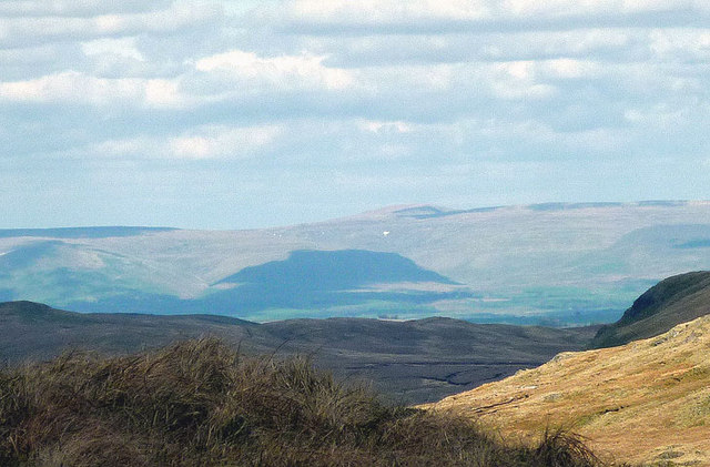
Scordale Head is a prominent landscape feature situated in the county of Westmorland, England. Located in the northern part of the county, it is part of the Pennines, a range of hills and mountains that form the backbone of England. Standing at an elevation of approximately 2,300 feet (700 meters), Scordale Head offers breathtaking views of the surrounding countryside.

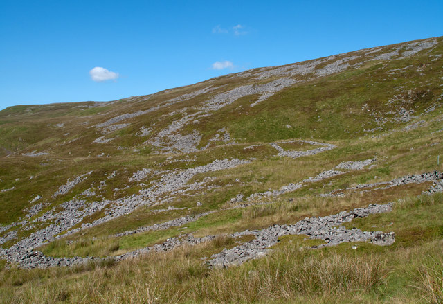
The area is characterized by its rugged and wild beauty, with steep slopes and craggy rock formations. The landscape is predominantly moorland, covered in heather and grasses, interspersed with rocky outcrops. Scordale Head is known for its distinctive shape, resembling a natural amphitheater, with the surrounding hills enclosing the area.

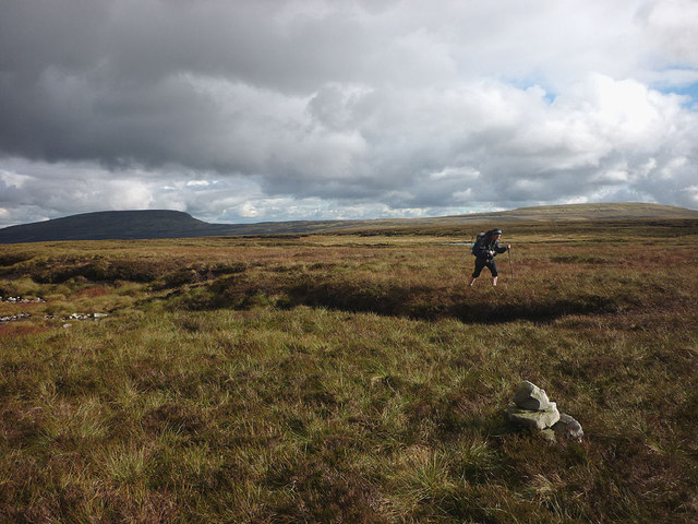
The site is popular among outdoor enthusiasts and nature lovers, offering numerous walking and hiking trails that wind through the hills and valleys. The views from the summit are particularly stunning, with panoramic vistas stretching for miles in every direction.

Scordale Head is also notable for its rich cultural and historical heritage. The area has been inhabited for centuries, and evidence of ancient settlements and farming practices can be found in the surrounding landscape. Additionally, Scordale Head is home to a variety of wildlife, including birds of prey, such as peregrine falcons and buzzards, as well as smaller mammals like rabbits and hares.

Overall, Scordale Head in Westmorland is a captivating landscape feature, offering a unique blend of natural beauty, outdoor activities, and historical significance.

If you have any feedback on the listing, please let us know in the comments section below.

Scordale Head Images

Images are sourced within 2km of 54.614679/-2.3624067 or Grid Reference NY7624. Thanks to Geograph Open Source API. All images are credited.

Shallow tarn near the summit of Murton Fell
Boulder rashes, Scordale Extensive areas of boulder such as are seen here on the western side of Scordale are very common in this side of the northern Pennines. Some of the boulder areas seen here appear to have been formed in to patterns - surely not for decoration!
There's a good many notices attached to low poles probably with 'no dig' symbols showing.  The area is of course in the MOD's Warcop range and such notices do appear occasionally all over the place but there may well be a particular concentration of them in the area.
Boulder rashes, Scordale
Extensive areas of boulder such as are seen here on the western side of Scordale are very common in this side of the northern Pennines. Some of the boulder areas seen here appear to have been formed in to patterns - surely not for decoration! There's a good many notices attached to low poles probably with 'no dig' symbols showing. The area is of course in the MOD's Warcop range and such notices do appear occasionally all over the place but there may well be a particular concentration of them in the area.
Murton Herds
Murton Herds
Disused dam above Scordale This was used by the miners as a source of water, possibly to power machinery. Just to the south there is a similar dam which appears to feed this one via a leat.
Disused dam above Scordale
This was used by the miners as a source of water, possibly to power machinery. Just to the south there is a similar dam which appears to feed this one via a leat.
Climbing out of upper Scordale After a break at the old sheepfold on the shelf below, it's a steep pull up to get to the curricks on Murton Fell.
Climbing out of upper Scordale
After a break at the old sheepfold on the shelf below, it's a steep pull up to get to the curricks on Murton Fell.
Ruined sheepfold, upper Scordale This old fold sits on a grassy shelf well above the old lead mine workings further down the dale.
Ruined sheepfold, upper Scordale
This old fold sits on a grassy shelf well above the old lead mine workings further down the dale.
Above upper Scordale Heading up the side of the upper valley above the area devastated by the old lead mine workings.
Above upper Scordale
Heading up the side of the upper valley above the area devastated by the old lead mine workings.
Curricks on Murton Fell 'Currick' is a local dialect term for a cairn. They may have been used by shepherds or miners as landmarks in poor weather. There are no visibility problems today, Mickle Fell being clearly in view.
Curricks on Murton Fell
'Currick' is a local dialect term for a cairn. They may have been used by shepherds or miners as landmarks in poor weather. There are no visibility problems today, Mickle Fell being clearly in view.
Curricks on Murton Fell (2) Two small but shapely cairns on a rash of gritstone boulders just above Scordale. Probably used by shepherds in the past as a navigational guide in poor weather. Mickle Fell beyond.
Curricks on Murton Fell (2)
Two small but shapely cairns on a rash of gritstone boulders just above Scordale. Probably used by shepherds in the past as a navigational guide in poor weather. Mickle Fell beyond.
Sunlight in Scordale Low autumn sun accentuates the gullies and folds on the far side of upper Scordale.
Sunlight in Scordale
Low autumn sun accentuates the gullies and folds on the far side of upper Scordale.
Moorland tarn, Murton Fell A sizeable but very shallow tarn sits between the two highest points of Murton Fell. It is so shallow and rock-strewn that windsurfing would probably not be a viable option here. The view is toward Mickle Fell, even further into the remote North Pennines wilderness.
Moorland tarn, Murton Fell
A sizeable but very shallow tarn sits between the two highest points of Murton Fell. It is so shallow and rock-strewn that windsurfing would probably not be a viable option here. The view is toward Mickle Fell, even further into the remote North Pennines wilderness.
On top of Murton Fell This tiny cairn is not quite the highest point of the fell. It probably has some significance for grouse shooters. The fell is almost the archetypal North Pennine mountain - acres of peat hags, soft going and wide open views. Here we are looking towards Mickle and Little Fells.
On top of Murton Fell
This tiny cairn is not quite the highest point of the fell. It probably has some significance for grouse shooters. The fell is almost the archetypal North Pennine mountain - acres of peat hags, soft going and wide open views. Here we are looking towards Mickle and Little Fells.
Shallow, rocky pool on Murton Fell Hollows in the peat which covers the top of the fell are sometimes occupied by these very shallow pools. They probably dry out at times (no chance of that this year!). Mickle Fell in the distance.
Shallow, rocky pool on Murton Fell
Hollows in the peat which covers the top of the fell are sometimes occupied by these very shallow pools. They probably dry out at times (no chance of that this year!). Mickle Fell in the distance.
Galena - lead ore This is what the old lead miners were after, galena which is the shiny, metallic crystal with a cubic structure. It is mainly lead sulphide - after crushing and smelting it would be reduced to pure lead.
Galena - lead ore
This is what the old lead miners were after, galena which is the shiny, metallic crystal with a cubic structure. It is mainly lead sulphide - after crushing and smelting it would be reduced to pure lead.
Last snow on the North Pennines? A zoom shot from 33km away on the fells above Longsleddale shows what appears to be a large patch of snow on the flank of Scordale.
Last snow on the North Pennines?
A zoom shot from 33km away on the fells above Longsleddale shows what appears to be a large patch of snow on the flank of Scordale.
Hilton Fell A large area of featureless peat moorland to the east of Scordale. The conical peak in the middle distance is Murton Pike with the Lakeland fells across the hazy Eden Valley.
Hilton Fell
A large area of featureless peat moorland to the east of Scordale. The conical peak in the middle distance is Murton Pike with the Lakeland fells across the hazy Eden Valley.
Shakeholes on Hilton Fell The moorland is pitted with shakeholes indicating the presence of limestone beneath the layer of peat. Mickle Fell beyond.
Shakeholes on Hilton Fell
The moorland is pitted with shakeholes indicating the presence of limestone beneath the layer of peat. Mickle Fell beyond.
Stone structure, Hilton Fell Although resembling a grouse butt there are no other examples nearby (butts are usually built in lines). This would appear to be a small shelter, possibly for shepherds up here in foul weather. Today, it is gloriously warm and sunny with a perfect view to Mickle Fell.
Stone structure, Hilton Fell
Although resembling a grouse butt there are no other examples nearby (butts are usually built in lines). This would appear to be a small shelter, possibly for shepherds up here in foul weather. Today, it is gloriously warm and sunny with a perfect view to Mickle Fell.
Show me another place!

Scordale Head is located at Grid Ref: NY7624 (Lat: 54.614679, Lng: -2.3624067)

Administrative County: Cumbria

District: Eden

Police Authority: Cumbria

What 3 Words

///marsh.awestruck.defected. Near Appleby-in-Westmorland, Cumbria

Nearby Locations

Scordale Head

Related Wikis

Appleby Fells

Appleby Fells is a Site of Special Scientific Interest in the Eden district of Cumbria, England, near Appleby-in-Westmorland. The area is approximately...

Warcop Training Area

The Warcop Training Area (WTA) is a UK Ministry of Defence military training area near the village of Warcop in Cumbria. Part of the Defence Training...

Murton Fell

Murton Fell is a hill of 675 metres (2,215 ft) above the village of Murton, Cumbria in Eden district, in the North Pennines. It lies east of the dramatic...

High Cup Gill

High Cup Gill (or High Cup Nick or just High Cup), almost a geometrically perfect U-shaped chasm, is a valley deeply incised into the Pennine scarp to...

Mickle Fell

Mickle Fell is a mountain in the Pennines, the range of hills and moors running down the middle of Northern England. It has a maximum elevation of 788...

Murton, Cumbria

Murton is a small village and civil parish in the Eden District of Cumbria, England. The parish had a population of 330 in 2001, rising to 360 at the 2011...

Moor House-Upper Teesdale

Moor House-Upper Teesdale National Nature Reserve covers 7,400 ha of the Pennine moors in the north of England. It straddles Cumbria and County Durham...

Hilton, Cumbria

Hilton is a village in Cumbria, England, in the civil parish of Murton, about 3 miles (4.8 km) east of Appleby-in-Westmorland and at an elevation of 752...

Have you been to Scordale Head?

Leave your review of Scordale Head below (or comments, questions and feedback).