Àird Ghoibhle

Landscape Feature in Ross-shire

Scotland

Àird Ghoibhle

A896, Glen Torridon The A896 runs 32 miles from Strathcarron to Kinlochewe.
<span class="nowrap"><a title="https://www.sabre-roads.org.uk/wiki/index.php?title=A896" rel="nofollow ugc noopener" href="https://www.sabre-roads.org.uk/wiki/index.php?title=A896">Link</a><img style="margin-left:2px;" alt="External link" title="External link - shift click to open in new window" src="https://s1.geograph.org.uk/img/external.png" width="10" height="10"/></span>
A896, Glen Torridon Credit: N Chadwick

Àird Ghoibhle is a spectacular landscape feature located in Ross-shire, Scotland. Situated on the western coast of the Highlands, this area boasts breathtaking views of the surrounding countryside and the stunning Loch Broom.

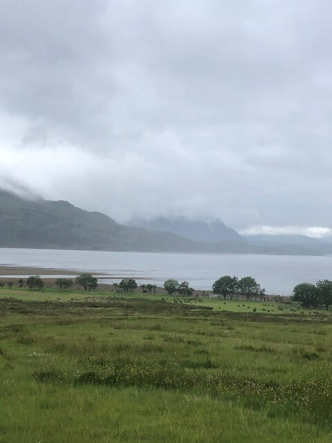
The landscape of Àird Ghoibhle is characterized by its rugged terrain and dramatic cliffs. The area is rich in natural beauty, with rolling hills, dense forests, and sparkling lochs. The prominent feature of Àird Ghoibhle is the imposing Ben Mor Coigach mountain, which stands tall at 743 meters and dominates the skyline. Its steep slopes and rocky outcrops make it a popular destination for hikers and climbers.

The coastline of Àird Ghoibhle is equally impressive, with its rocky shores and picturesque beaches. The area is known for its diverse wildlife, including seabirds, seals, and occasionally dolphins and whales. The clear waters of Loch Broom provide excellent opportunities for fishing and water sports.

The surrounding countryside is home to a variety of flora and fauna, including heather, wildflowers, and mosses. The area is also known for its ancient woodland, which is home to a rich array of plant and animal species.

In addition to its natural beauty, Àird Ghoibhle also has a rich cultural history. The area is dotted with ancient ruins, including standing stones and burial cairns, which provide a glimpse into the past. The local community takes great pride in preserving and celebrating this heritage.

Overall, Àird Ghoibhle is a captivating landscape feature that offers visitors a unique blend of natural beauty, outdoor activities, and historical significance.

If you have any feedback on the listing, please let us know in the comments section below.

Àird Ghoibhle Images

Images are sourced within 2km of 57.551285/-5.5288027 or Grid Reference NG8856. Thanks to Geograph Open Source API. All images are credited.
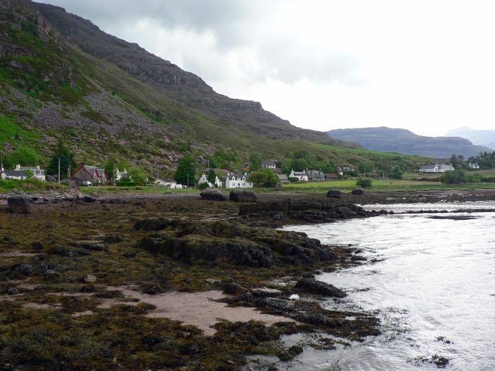
A896, Glen Torridon The A896 runs 32 miles from Strathcarron to Kinlochewe.
<span class="nowrap"><a title="https://www.sabre-roads.org.uk/wiki/index.php?title=A896" rel="nofollow ugc noopener" href="https://www.sabre-roads.org.uk/wiki/index.php?title=A896">Link</a><img style="margin-left:2px;" alt="External link" title="External link - shift click to open in new window" src="https://s1.geograph.org.uk/img/external.png" width="10" height="10"/></span>
A896, Glen Torridon
The A896 runs 32 miles from Strathcarron to Kinlochewe. LinkExternal link
Torridon village from above Annat The village is dwarfed by the flanks of Liathach.
Torridon village from above Annat
The village is dwarfed by the flanks of Liathach.
Doire an Fuaran - Field of Springs An old township, made up of three crofting communities, was here until 1845 when the tenants were forced to leave their land to be replaced by sheep. The ruins of the former crofts are still here in this moorland
Doire an Fuaran - Field of Springs
An old township, made up of three crofting communities, was here until 1845 when the tenants were forced to leave their land to be replaced by sheep. The ruins of the former crofts are still here in this moorland
Faint footpath in Doire an Fuaran (Field of the Springs) A path takes you around the former crofting community which lies in a field behind the village of Fasag
Faint footpath in Doire an Fuaran (Field of the Springs)
A path takes you around the former crofting community which lies in a field behind the village of Fasag
Stream in the Field of the Springs
Torridon Mountain Rescue Team building
Village below the mountain A view across the fields from Annat to Torridon village which sits almost at sea level with the huge flank of Liathach immediately behind. The mountain goes from sea level to over 1000m in one great sweep. The second highest point of the mountain, Mullach an Rathain [1023m] is just off camera to the right. In the centre of the village buildings can be seen the modern fitness and community centre, which also has an excellent cafe for those exhausted by looking at Liathach.
Village below the mountain
A view across the fields from Annat to Torridon village which sits almost at sea level with the huge flank of Liathach immediately behind. The mountain goes from sea level to over 1000m in one great sweep. The second highest point of the mountain, Mullach an Rathain [1023m] is just off camera to the right. In the centre of the village buildings can be seen the modern fitness and community centre, which also has an excellent cafe for those exhausted by looking at Liathach.
A meadow awaiting the sweep of the hay-maker's scythe A dry-stane wall, topped by three strands of wire that are intended to deter wall climbing sheep, overlooks a meadow scattered with the white seed heads of Cotton-grass, and patiently anticipating the sweep of the hay-maker's scythe. Beyond the vista across Glen Torridon is lost in the mist.
A meadow awaiting the sweep of the hay-maker's scythe
A dry-stane wall, topped by three strands of wire that are intended to deter wall climbing sheep, overlooks a meadow scattered with the white seed heads of Cotton-grass, and patiently anticipating the sweep of the hay-maker's scythe. Beyond the vista across Glen Torridon is lost in the mist.
The head of Loch Torridon A view from the Hill Track from Annat to Achnashellach and Coulags in Glen Carron.
The head of Loch Torridon
A view from the Hill Track from Annat to Achnashellach and Coulags in Glen Carron.
Upper Loch Torridon
Upper Loch Torridon
Torridon Serious mountain country - Torridon village nestles along the shore-line of Loch Torridon, overlooked by a series of  imposing mountains.
Torridon
Serious mountain country - Torridon village nestles along the shore-line of Loch Torridon, overlooked by a series of imposing mountains.
Rails to Sgùrr na Bana-Mhoraire From the MHWS mark, old rusty rails stretch across the pebbled shore, reaching out from the boathouse, their journey leading to Loch Torridon where the tide is at half-tide, a line marked, I estimate, by the ethereal northing. On the distant horizon, across the tranquil waters of Loch Torridon, stands Sgùrr na Bana-Mhoraire, the "peak of the lady," its name echoing the tale of a forlorn lady who was ordered to endure the summit's harsh embrace, surviving solely on seafood brought to her, a tragic consequence of her lord's merciless judgment for some transgression.

Source: Drummond, Peter. "Scottish Hill Names." Page 196. Scottish Mountaineering Trust. 1992.
Rails to Sgùrr na Bana-Mhoraire
From the MHWS mark, old rusty rails stretch across the pebbled shore, reaching out from the boathouse, their journey leading to Loch Torridon where the tide is at half-tide, a line marked, I estimate, by the ethereal northing. On the distant horizon, across the tranquil waters of Loch Torridon, stands Sgùrr na Bana-Mhoraire, the "peak of the lady," its name echoing the tale of a forlorn lady who was ordered to endure the summit's harsh embrace, surviving solely on seafood brought to her, a tragic consequence of her lord's merciless judgment for some transgression. Source: Drummond, Peter. "Scottish Hill Names." Page 196. Scottish Mountaineering Trust. 1992.
Half-tide at Loch Torridon On the pebble shore of Loch Torridon, Bladderwrack asserts its dominance as the tide gently recedes. In the distance horizon, across the tranquil waters, stands Sgùrr na Bana-Mhoraire, the "peak of the lady," its name echoing the tale of a forlorn lady who was ordered to endure the summit's harsh embrace, surviving solely on seafood brought to her, a tragic consequence of her lord's merciless judgment for some transgression.

Source: Drummond, Peter. "Scottish Hill Names." Page 196. Scottish Mountaineering Trust. 1992.
Half-tide at Loch Torridon
On the pebble shore of Loch Torridon, Bladderwrack asserts its dominance as the tide gently recedes. In the distance horizon, across the tranquil waters, stands Sgùrr na Bana-Mhoraire, the "peak of the lady," its name echoing the tale of a forlorn lady who was ordered to endure the summit's harsh embrace, surviving solely on seafood brought to her, a tragic consequence of her lord's merciless judgment for some transgression. Source: Drummond, Peter. "Scottish Hill Names." Page 196. Scottish Mountaineering Trust. 1992.
Allt Ghoibhle Allt Ghoibhle, a humble stream, tumbles down to Loch Torridon. Its waters dancing over rugged rocks, embraced by bracken with the occasional sprig of purple Bell heather. Higher up the brae of Liathach, Silver birch and Rowan trees become few and far between, and the hillside grows wilder and rockier.
Allt Ghoibhle
Allt Ghoibhle, a humble stream, tumbles down to Loch Torridon. Its waters dancing over rugged rocks, embraced by bracken with the occasional sprig of purple Bell heather. Higher up the brae of Liathach, Silver birch and Rowan trees become few and far between, and the hillside grows wilder and rockier.
Half-tide at Loch Torridon; a view to Beinn na h-Eaglaise On the pebble shore of Loch Torridon, Bladderwrack asserts its dominance as the tide gently recedes. In the distance horizon, across the tranquil waters, stands Beinn na h-Eaglaise, "the hill of the church," perhaps a reminder of the importance that the Christian religion played in the clansmen's lives.

Source: Drummond, Peter. "Scottish Hill Names." Page 194. Scottish Mountaineering Trust. 1992.
Half-tide at Loch Torridon; a view to Beinn na h-Eaglaise
On the pebble shore of Loch Torridon, Bladderwrack asserts its dominance as the tide gently recedes. In the distance horizon, across the tranquil waters, stands Beinn na h-Eaglaise, "the hill of the church," perhaps a reminder of the importance that the Christian religion played in the clansmen's lives. Source: Drummond, Peter. "Scottish Hill Names." Page 194. Scottish Mountaineering Trust. 1992.
View to Mol Mòr A dry-stone wall, crowned by three strands of slackened wire, supposedly intended, when taut, to deter wall climbing sheep, overlooks a meadow patiently anticipating the sweep of the hay-maker's scythe. Beyond, Mol Mòr catches the eye, its name signifying a "large shingly beach," at the head of Loch Torridon, where the distant bank vanishes into the mist.
View to Mol Mòr
A dry-stone wall, crowned by three strands of slackened wire, supposedly intended, when taut, to deter wall climbing sheep, overlooks a meadow patiently anticipating the sweep of the hay-maker's scythe. Beyond, Mol Mòr catches the eye, its name signifying a "large shingly beach," at the head of Loch Torridon, where the distant bank vanishes into the mist.
Aftermath of Torridon fire May 2011,#1 This update to <a href="https://www.geograph.org.uk/photo/182822">NG9055 : Torridon Fire Station.</a> by Dave Fergusson shows how close the spring fire of 2011 came to the fire station.  The crew had just left to respond to yet another smouldering remnant of the four square miles devastated.
Aftermath of Torridon fire May 2011,#1
This update to NG9055 : Torridon Fire Station. by Dave Fergusson shows how close the spring fire of 2011 came to the fire station. The crew had just left to respond to yet another smouldering remnant of the four square miles devastated.
Aftermath of Torridon fire May 2011,#2 Shows the fairly new bus-shelter badly damaged by the spring bush fire of 2011 with the far panel melted.  The hill face behind shows the blackened areas of burned out scrub and trees.
Aftermath of Torridon fire May 2011,#2
Shows the fairly new bus-shelter badly damaged by the spring bush fire of 2011 with the far panel melted. The hill face behind shows the blackened areas of burned out scrub and trees.
Show me another place!

Àird Ghoibhle is located at Grid Ref: NG8856 (Lat: 57.551285, Lng: -5.5288027)

Unitary Authority: Highland

Police Authority: Highlands and Islands

What 3 Words

///earpiece.vocal.buzzer. Near Kinlochewe, Highland

Nearby Locations

Àird Ghoibhle

Related Wikis

Torridon

Torridon (Scottish Gaelic: Toirbheartan) is a small village in the Northwest Highlands of Scotland. However the name is also applied to the area surrounding...

Torridon Hills

The Torridon Hills surround Torridon village in the Northwest Highlands of Scotland. The name is usually applied to the mountains to the north of Glen...

Annat, Highland

Annat (Scottish Gaelic: An Annaid) is a small village at the eastern end of Upper Loch Torridon in Wester Ross, in the Highland council area of Scotland...

Beinn Dearg (Torridon)

Beinn Dearg is the fourth highest of the Torridon Hills in the highlands of Scotland. Beinn Dearg offers all the typical features of a Torridon hill, with...

Nearby Amenities

Located within 500m of 57.551285,-5.5288027
Source: PGS
Lat/Long: 57.5525288/-5.5366812
Source: PGS
Lat/Long: 57.5523928/-5.5354291
Created By: almien_coastlines
Source: PGS
Lat/Long: 57.552484/-5.53455
Source: PGS
Lat/Long: 57.5525939/-5.5337808
Created By: almien_coastlines
Source: PGS
Lat/Long: 57.552385/-5.533114
Source: PGS
Lat/Long: 57.5521087/-5.5325286
Source: PGS
Lat/Long: 57.5515434/-5.5320166
Source: PGS
Lat/Long: 57.551163/-5.5317603
Created By: almien_coastlines
Source: PGS
Lat/Long: 57.551006/-5.531588
Created By: almien_coastlines
Source: PGS
Lat/Long: 57.55076/-5.531095
Source: PGS
Lat/Long: 57.5505647/-5.5303955
Source: PGS
Lat/Long: 57.5503118/-5.5292602
Source: PGS
Lat/Long: 57.5504493/-5.5279713
Created By: almien_coastlines
Source: PGS
Lat/Long: 57.55059/-5.526796
Source: PGS
Lat/Long: 57.5506515/-5.5262741
Source: PGS
Lat/Long: 57.5504402/-5.5243489
Source: PGS
Lat/Long: 57.5501196/-5.5229129
Source: PGS
Lat/Long: 57.5499377/-5.5223397
Source: PGS
Lat/Long: 57.5498959/-5.521396
Source: PGS
Lat/Long: 57.5499416/-5.520926
Passing Place
Lat/Long: 57.5526213/-5.5349413
Aird Ghoibhle
Place: locality
Lat/Long: 57.5510891/-5.5296426
Sron Aird Ghoibhle
Place: locality
Lat/Long: 57.5496385/-5.5295016
Passing Place
Lat/Long: 57.5525051/-5.5329079
Passing Place
Lat/Long: 57.5514642/-5.5315668
Power: pole
Lat/Long: 57.5533966/-5.5352411
Power: pole
Lat/Long: 57.5531581/-5.534006
Power: pole
Lat/Long: 57.5529488/-5.5328923
Power: pole
Lat/Long: 57.5526854/-5.5314841
Power: pole
Lat/Long: 57.5520033/-5.5307967
Power: pole
Lat/Long: 57.5515278/-5.5302825
Power: pole
Lat/Long: 57.5514238/-5.5290887
Power: pole
Lat/Long: 57.5512866/-5.5277554
Power: pole
Lat/Long: 57.5511743/-5.5265642
Power: pole
Lat/Long: 57.5510647/-5.525342
Power: pole
Lat/Long: 57.5509455/-5.5240501
Power: pole
Lat/Long: 57.5508249/-5.5228511
Power: pole
Lat/Long: 57.5507064/-5.5215398
The data included in this document is from www.openstreetmap.org. The data is made available under ODbL.

Have you been to Àird Ghoibhle?

Leave your review of Àird Ghoibhle below (or comments, questions and feedback).