Aird Dhubh

Landscape Feature in Ross-shire

Scotland

Aird Dhubh

Abandoned House A house near the shore of Tòb Cheann Tarabhaigh, an ilnet of Loch Seaforth.
Abandoned House Credit: Anne Burgess

Aird Dhubh is a prominent landscape feature located in the county of Ross-shire, Scotland. Situated on the western coast, it is characterized by its stunning cliffs, jagged rocks, and breathtaking views of the North Atlantic Ocean.

The cliffs at Aird Dhubh are composed of rugged sandstone formations, which have been shaped by the relentless force of the crashing waves over thousands of years. These cliffs reach impressive heights, providing an awe-inspiring backdrop against the turquoise waters below. Aird Dhubh is a haven for birdwatchers, as the cliffs are home to nesting seabirds such as guillemots, fulmars, and razorbills.

The jagged rocks that protrude from the ocean at Aird Dhubh add to the dramatic scenery of the area. These rocks are remnants of ancient volcanic activity, and their unique shapes have been sculpted by the elements over time. At low tide, it is possible to explore the rock pools that form around these structures, revealing a diverse range of marine life such as crabs, starfish, and small fish.

The views from Aird Dhubh are simply breathtaking. On a clear day, one can see the distant peaks of the Outer Hebrides to the west, while to the east, the towering mountains of the Scottish Highlands provide a majestic backdrop. The ever-changing weather conditions in this coastal region contribute to the dynamic beauty of the landscape.

Overall, Aird Dhubh in Ross-shire is a captivating landscape feature, offering visitors a unique opportunity to experience the rugged beauty of Scotland's western coast.

If you have any feedback on the listing, please let us know in the comments section below.

Aird Dhubh Images

Images are sourced within 2km of 58.049135/-6.6626674 or Grid Reference NB2416. Thanks to Geograph Open Source API. All images are credited.

Abandoned House A house near the shore of Tòb Cheann Tarabhaigh, an ilnet of Loch Seaforth.
Abandoned House
A house near the shore of Tòb Cheann Tarabhaigh, an ilnet of Loch Seaforth.
Loyal Hebrideans Monument The reason of the monument is explained in <a href="https://www.geograph.org.uk/photo/3481007">NB2517 : Plaque on a monument to the Hebrideans</a>. I regret not having found something else to photograph in this square!
Loyal Hebrideans Monument
The reason of the monument is explained in NB2517 : Plaque on a monument to the Hebrideans. I regret not having found something else to photograph in this square!
Abandoned croft house at Airidh a Bhruaich On the shore of Tòb Cheann Tarabhaigh.
Abandoned croft house at Airidh a Bhruaich
On the shore of Tòb Cheann Tarabhaigh.
Croft at Airidh a Bhruaich Almost no change over 5 years <a href="https://www.geograph.org.uk/photo/572440">NB2417 : Croft at  Airidh  a'  Bhruaich</a>
Croft at Airidh a Bhruaich
Almost no change over 5 years NB2417 : Croft at Airidh a' Bhruaich
Cairn at Airidh a' Bhruaich Commemorating the landing here of Charles Edward Stuart [Bonnie Prince Charlie] on 4 May 1746, while on the run after the battle of Culloden 18 days earlier.
Cairn at Airidh a' Bhruaich
Commemorating the landing here of Charles Edward Stuart [Bonnie Prince Charlie] on 4 May 1746, while on the run after the battle of Culloden 18 days earlier.
House near Airidh a' Bhruaich With a shelter of trees to protect from the elements.
House near Airidh a' Bhruaich
With a shelter of trees to protect from the elements.
Croft houses at Airidh a' Bhruaich By the A859, overlooking Tob Cheann Tarabhaigh.
Croft houses at Airidh a' Bhruaich
By the A859, overlooking Tob Cheann Tarabhaigh.
Plaque on a monument to the Hebrideans Commemorating the fact that they did not betray Charles Edward Stuart [Bonnie Prince Charlie] when he was on the run after Culloden and landed here on 4 May 1746, in spite of a bounty of £30000 on offer.
Plaque on a monument to the Hebrideans
Commemorating the fact that they did not betray Charles Edward Stuart [Bonnie Prince Charlie] when he was on the run after Culloden and landed here on 4 May 1746, in spite of a bounty of £30000 on offer.
Monument to the loyalty of the Hebrideans Above the crofting township of Airidh a' Bhruaich. Commemorating the fact that Charles Edward Stuart [Bonnie Prince Charlie] was not betrayed by them when he was on the run after Culloden and landed here on 4 May 1746, in spite of a bounty of £30000 on offer.
Monument to the loyalty of the Hebrideans
Above the crofting township of Airidh a' Bhruaich. Commemorating the fact that Charles Edward Stuart [Bonnie Prince Charlie] was not betrayed by them when he was on the run after Culloden and landed here on 4 May 1746, in spite of a bounty of £30000 on offer.
Memorial near Loch Seaforth
House at Arivruaich / Airidh a' Bhruaich
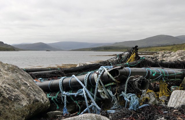
Debris on the shore of Loch Seaforth/Loch Shiphoirt, Isle of Lewis I assume the debris has drifted from a fish farm.
Debris on the shore of Loch Seaforth/Loch Shiphoirt, Isle of Lewis
I assume the debris has drifted from a fish farm.
View across moorland from Corra Chnoc, Isle of Lewis Looking towards Cearnabhal, the top of which is in the cloud.
View across moorland from Corra Chnoc, Isle of Lewis
Looking towards Cearnabhal, the top of which is in the cloud.
Fields and houses at Airidh a' Bhruaich
Loch a' Chorra Chnoic, Isle of Lewis According to the OS Name Book of 1848-1852, Loch a' Chorra Chnoic means Steep Hill Loch.
Loch a' Chorra Chnoic, Isle of Lewis
According to the OS Name Book of 1848-1852, Loch a' Chorra Chnoic means Steep Hill Loch.
Ruined farmstead by Loch Seaforth/Loch Shiphoirt, Isle of Lewis The farmstead is marked as a ruin on the 1st Edition OS map surveyed during 1850-53.
Ruined farmstead by Loch Seaforth/Loch Shiphoirt, Isle of Lewis
The farmstead is marked as a ruin on the 1st Edition OS map surveyed during 1850-53.
Dorus Beag, Loch Seaforth/Loch Shiphoirt, Isle of Lewis Dorus Beag is the channel between the shore and a rock called Sgeir Liath which was under water at the time the photo was taken.  Dorus Beag means Little Door.
Dorus Beag, Loch Seaforth/Loch Shiphoirt, Isle of Lewis
Dorus Beag is the channel between the shore and a rock called Sgeir Liath which was under water at the time the photo was taken. Dorus Beag means Little Door.
Shieling mound, Rubha Àirigh an t-Sruth, Loch Seaforth/Loch Shiphoirt, Isle of Lewis According to the OS Name Book of 1848-1852, Rubha Àirigh an t-Sruth means The Streams Shieling's point.
Shieling mound, Rubha Àirigh an t-Sruth, Loch Seaforth/Loch Shiphoirt, Isle of Lewis
According to the OS Name Book of 1848-1852, Rubha Àirigh an t-Sruth means The Streams Shieling's point.
Show me another place!

Aird Dhubh is located at Grid Ref: NB2416 (Lat: 58.049135, Lng: -6.6626674)

Unitary Authority: Na h-Eileanan an Iar

Police Authority: Highlands and Islands

What 3 Words

///digests.extreme.earmarked. Near Leurbost, Na h-Eileanan Siar

Related Wikis

Airidh a' Bhruaich

Airidh a' Bhruaich (Arivruaich - anglicised) is a scattered crofting township in the South Lochs district of the Isle of Lewis in the Outer Hebrides of...

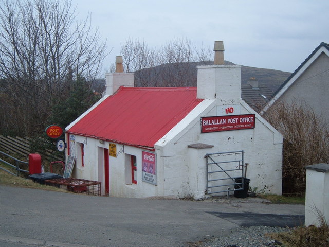
Balallan

Balallan (Scottish Gaelic: Baile Ailein, Bail' Ailein), meaning "Allan's Town", is a crofting township on the Isle of Lewis, in the Outer Hebrides, Scotland...

Seaforth Island

Seaforth Island (Scottish Gaelic: Eilean Shìphoirt/Shìophoirt or Mulag) is an uninhabited island in the Outer Hebrides of Scotland. Unlike many other...

Eilean Mòr, Loch Langavat

Eilean Mòr is an island in Loch Langavat on the Isle of Lewis in the Outer Hebrides of Scotland. == Footnotes ==

Nearby Amenities

Located within 500m of 58.049135,-6.6626674
Struth Sheaford
Natural: strait
Lat/Long: 58.0473195/-6.668154
The data included in this document is from www.openstreetmap.org. The data is made available under ODbL.

Have you been to Aird Dhubh?

Leave your review of Aird Dhubh below (or comments, questions and feedback).