Àird Chòinnich

Landscape Feature in Ross-shire

Scotland

Àird Chòinnich

Loch Laxavat Ard
Loch Laxavat Ard Credit: Peter Moore

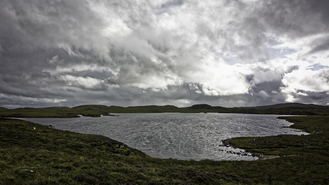
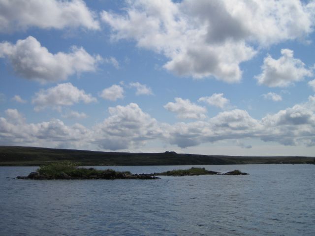
Àird Chòinnich, located in Ross-shire, Scotland, is a striking landscape feature that captivates visitors with its rugged charm and natural beauty. This stunning coastal headland is situated on the northwestern coast of the Scottish Highlands, overlooking the vast expanse of the North Atlantic Ocean.

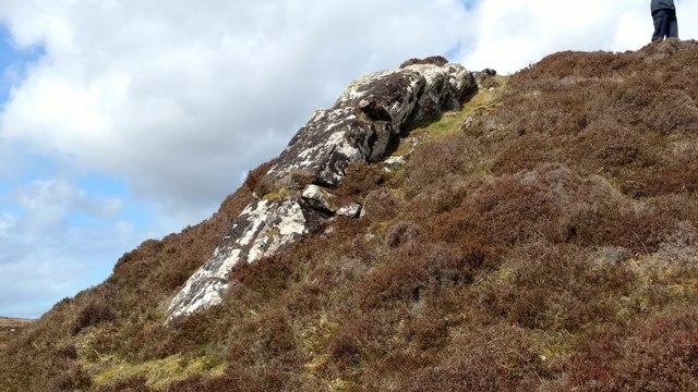
The most prominent feature of Àird Chòinnich is its towering cliffs that rise dramatically from the sea, reaching heights of up to 200 feet. The cliffs are composed of ancient rock formations, showcasing layers of sedimentary rocks that have been shaped and sculpted by centuries of erosion. This geological wonder provides a glimpse into the region's rich geological history.

The headland is also home to a diverse array of flora and fauna, making it a haven for nature lovers and wildlife enthusiasts. Seabirds such as puffins, gannets, and fulmars can be spotted nesting on the cliffs, while marine mammals like seals and dolphins are often seen swimming in the waters below. The surrounding heathland and coastal grasses are adorned with wildflowers, creating a colorful tapestry that adds to the area's natural allure.

In addition to its natural wonders, Àird Chòinnich is steeped in history. The ruins of an ancient broch, an Iron Age fortified structure, can be found on the headland, serving as a reminder of the area's ancient inhabitants. The broch offers a glimpse into the lives of the people who once called this rugged coastline home.

Overall, Àird Chòinnich is a breathtaking landscape feature that combines stunning cliffs, diverse wildlife, and historical remnants to create a truly magical and unforgettable experience for all who visit.

If you have any feedback on the listing, please let us know in the comments section below.

Àird Chòinnich Images

Images are sourced within 2km of 58.2443/-6.7022308 or Grid Reference NB2438. Thanks to Geograph Open Source API. All images are credited.

Loch Laxavat Ard
Loch Laxavat Ard
Loch Lacsabhat Iarach By the Pentland Road.
Loch Lacsabhat Iarach
By the Pentland Road.
Bog beside the Pentland Road Looking towards Beinn Braghair (261 metres).
Bog beside the Pentland Road
Looking towards Beinn Braghair (261 metres).
Loch Laxavat Ard/Lagasbhat Ard Beside the Pentland Road.
Loch Laxavat Ard/Lagasbhat Ard
Beside the Pentland Road.
Druim na Bràiste Looking towards Loch na Bràiste.
Druim na Bràiste
Looking towards Loch na Bràiste.
Loch Lagsabhat Ard By Druim Mòr Connaidh Lagsabhat
Loch Lagsabhat Ard
By Druim Mòr Connaidh Lagsabhat
The southern end of Loch Lagsabhat Àrd
Rocky knoll at 72m spot height south of Pentland Rd, Carloway, Lewis Tramp out across the bog to the tiny hump that is this 72 metre spot height amidst the wilderness of Lewis.  Then drop down the S.E. side and this is what you'll see.  Can't guarantee my wife's legs will be there when you go to check.
Rocky knoll at 72m spot height south of Pentland Rd, Carloway, Lewis
Tramp out across the bog to the tiny hump that is this 72 metre spot height amidst the wilderness of Lewis. Then drop down the S.E. side and this is what you'll see. Can't guarantee my wife's legs will be there when you go to check.
Roadside memorial to Murdo Macleod On the lonely bog-traversing Pentland Road twixt Carloway and Stornoway lies this memorial to a man who dropped dead at this spot on 1st June 1902 aged just 40.  If anyone ever contacts me to tell me the cause, I will be delighted to update this page.  Murdo was clearly loved by his descendants.
Roadside memorial to Murdo Macleod
On the lonely bog-traversing Pentland Road twixt Carloway and Stornoway lies this memorial to a man who dropped dead at this spot on 1st June 1902 aged just 40. If anyone ever contacts me to tell me the cause, I will be delighted to update this page. Murdo was clearly loved by his descendants.
View from the knoll at 72m spot height My previous image from this spot shows what's underfoot, this one shows the view roughly south.  Bog, some bog, then a boggy patch.  Two lochans which I think are called Loch Mòr and Loch Gheòidh can be seen mid distant.
Off Pentland Rd, Carloway, Isle of Lewis.
View from the knoll at 72m spot height
My previous image from this spot shows what's underfoot, this one shows the view roughly south. Bog, some bog, then a boggy patch. Two lochans which I think are called Loch Mòr and Loch Gheòidh can be seen mid distant. Off Pentland Rd, Carloway, Isle of Lewis.
Loch Lagsabhat Àrd from Pentland Road
Pentland Road Part of the "back road" from Carloway to Stornoway.
Pentland Road
Part of the "back road" from Carloway to Stornoway.
Loch Laxavat Ard With Fish Farm equipment on shore. Many of hundreds of lochs on the Isle of Lewis are used by Fish Farms.
Loch Laxavat Ard
With Fish Farm equipment on shore. Many of hundreds of lochs on the Isle of Lewis are used by Fish Farms.
Loch Airigh Seibh Islets (not shown on the map) on the loch.
Loch Airigh Seibh
Islets (not shown on the map) on the loch.
Peat Moorland Beagha Looking over the single track road from Carlabhagh to Stornoway to the moorland. The OS map merely has the word "Beagha" normal to the usual text to describe this area.
Peat Moorland Beagha
Looking over the single track road from Carlabhagh to Stornoway to the moorland. The OS map merely has the word "Beagha" normal to the usual text to describe this area.
Eilean Ard on  Loch Laxavat Ard This island at the south-eastern end of the loch could be natural or may be an iron age dun or crannog.
Eilean Ard on Loch Laxavat Ard
This island at the south-eastern end of the loch could be natural or may be an iron age dun or crannog.
Loch Laxavat Ard Loch Laxavat Ard, Lewis, set amongst rocky moorland
Loch Laxavat Ard
Loch Laxavat Ard, Lewis, set amongst rocky moorland
Loch Clacharain
Loch Clacharain
Show me another place!

Àird Chòinnich is located at Grid Ref: NB2438 (Lat: 58.2443, Lng: -6.7022308)

Unitary Authority: Na h-Eileanan an Iar

Police Authority: Highlands and Islands

What 3 Words

///organic.amplifier.wardrobe. Near Carloway, Na h-Eileanan Siar

Related Wikis

Lewis and Harris

Lewis and Harris (Scottish Gaelic: Leòdhas agus Na Hearadh, Scots: Lewis an Harris), or Lewis with Harris, is a single Scottish island in the Outer Hebrides...

Breasclete

Breasclete (Scottish Gaelic: Brèascleit) is a village and community on the west side of the Isle of Lewis, in the Outer Hebrides, Scotland. Breasclete...

Callanish X

The Callanish X stone circle (or "Na Dromannan", "Druim Nan Eun") is one of many megalithic structures around the more well-known and larger Calanais I...

Tolsta Chaolais

Tolsta Chaolais (also Tolastadh Chaolais, Tolstadh a' Chaolais) is a village on the Isle of Lewis, Scotland. It consists of about forty houses, clustered...

Have you been to Àird Chòinnich?

Leave your review of Àird Chòinnich below (or comments, questions and feedback).