Slapton Ley
Lake, Pool, Pond, Freshwater Marsh in Devon South Hams
England
Slapton Ley

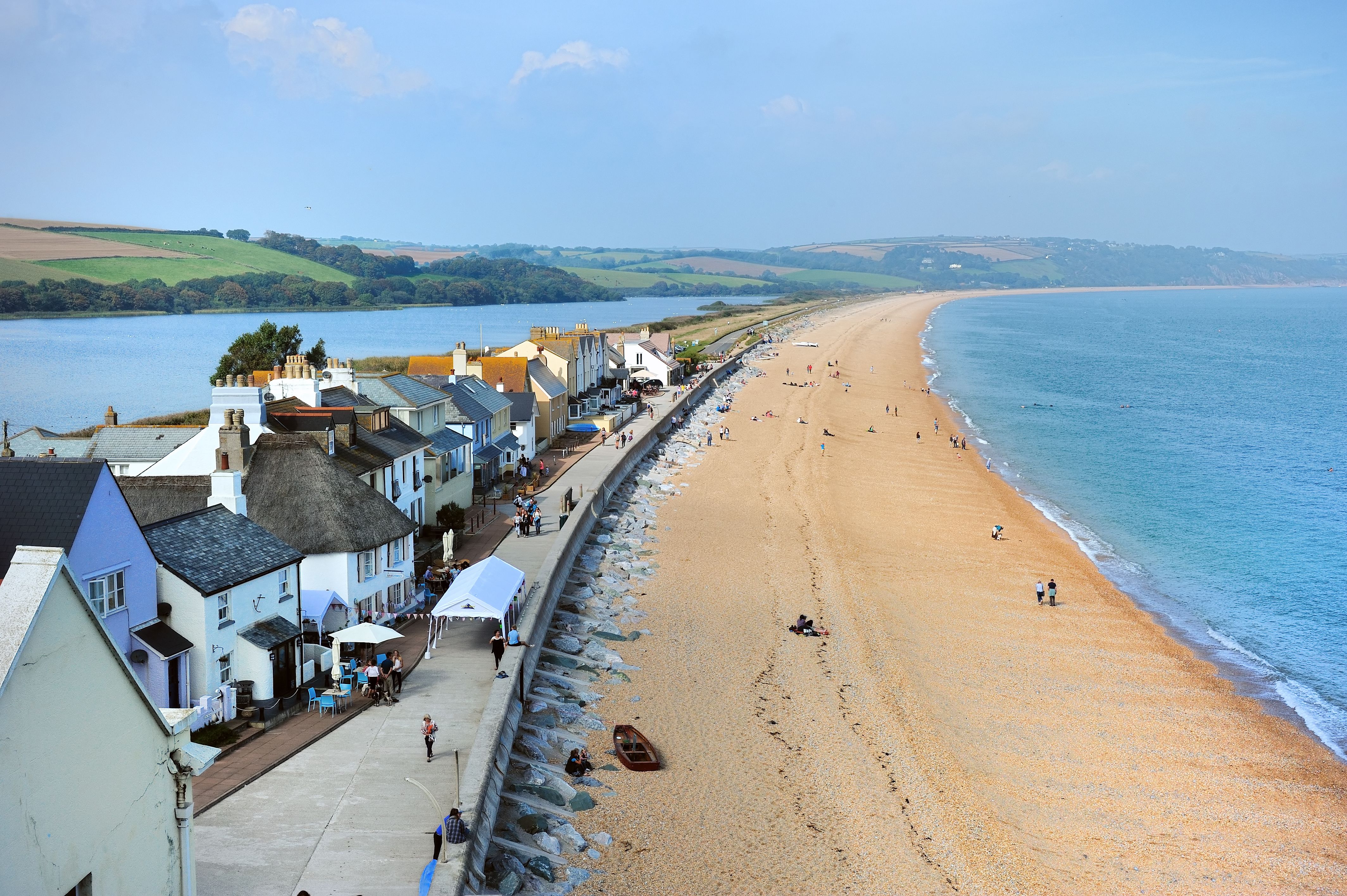
Slapton Ley, located in Devon, England, is a freshwater lake known for its ecological significance and natural beauty. With a surface area of approximately 1.5 square kilometers, it is the largest natural freshwater lake in southwest England. The lake is situated between the villages of Slapton and Torcross and is bordered by rolling hills and woodlands.
Slapton Ley is a designated Site of Special Scientific Interest (SSSI) due to its rich biodiversity and rare habitats. The lake itself is a result of a shingle bar, known as Slapton Sands, which separates it from the sea. This unique feature creates a brackish environment, making it a haven for a wide variety of flora and fauna.
The lake is home to numerous species of waterfowl, such as mallards, coots, and tufted ducks, which can be spotted throughout the year. It also serves as an important breeding ground for migratory birds, including little grebes and great crested grebes. The surrounding woodlands attract a plethora of songbirds, making it a popular destination for birdwatchers.
The lake is flanked by a freshwater marsh, which is a vital habitat for many rare and endangered species. It supports a diverse range of plant life, including reeds, sedges, and water lilies. In the summer months, the marsh transforms into a colorful display as wildflowers bloom, attracting butterflies and dragonflies.
Slapton Ley offers a range of recreational activities for visitors, including walking trails, birdwatching hides, and guided nature walks. Its tranquil surroundings and picturesque landscapes make it a popular destination for nature enthusiasts and photographers alike.
If you have any feedback on the listing, please let us know in the comments section below.
Slapton Ley Images
Images are sourced within 2km of 50.27583/-3.6520762 or Grid Reference SX8243. Thanks to Geograph Open Source API. All images are credited.


Slapton Ley is located at Grid Ref: SX8243 (Lat: 50.27583, Lng: -3.6520762)
Administrative County: Devon
District: South Hams
Police Authority: Devon and Cornwall
Also known as: Lower Ley
What 3 Words
///disputes.hobbit.strutting. Near Kingsbridge, Devon
Nearby Locations
Related Wikis
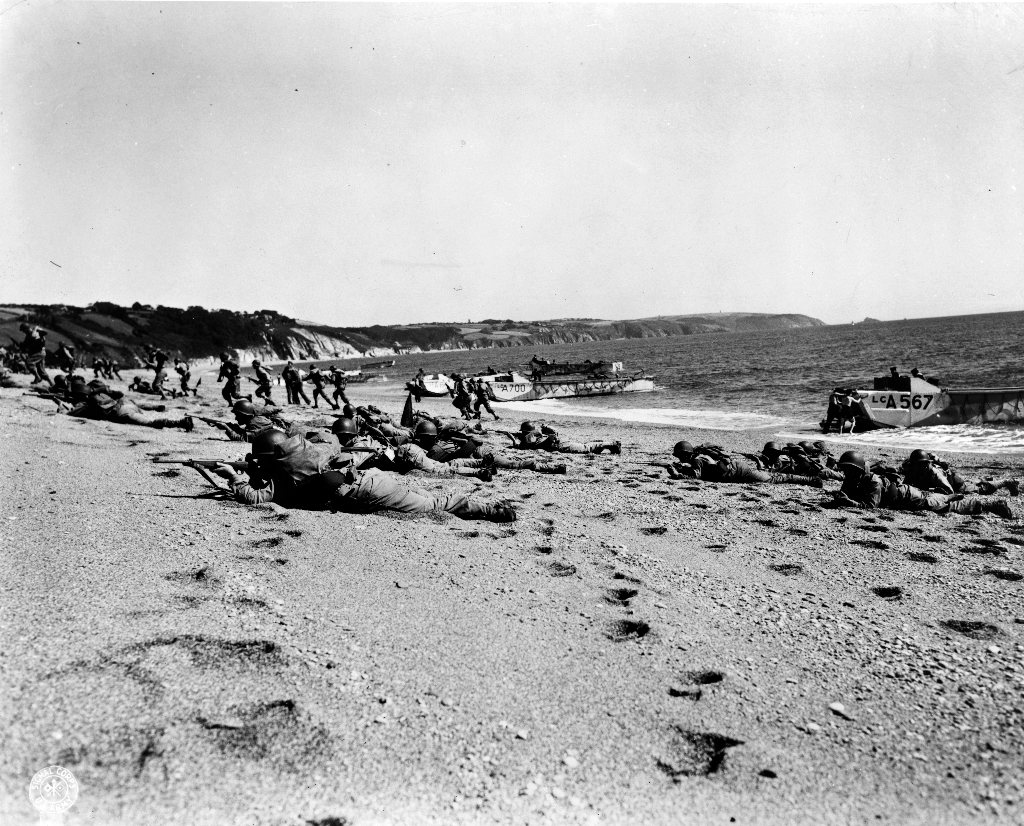
Exercise Tiger
Exercise Tiger, or Operation Tiger, was one of a series of large-scale rehearsals for the D-Day invasion of Normandy, which took place in April 1944 on...

Slapton Ley
Slapton Ley is a lake on the south coast of Devon, England, separated from Start Bay by a shingle beach, known as Slapton Sands. Slapton Ley is the largest...
Torcross
Torcross is a seaside village in the South Hams district of south Devon in England. It stands at grid reference SX822420 at the southern end of Slapton...
Stokenham
Stokenham () is a village and civil parish in the South Hams district, in the county of Devon, England. The population of the parish at the 2011 census...
Nearby Amenities
Located within 500m of 50.27583,-3.6520762Have you been to Slapton Ley?
Leave your review of Slapton Ley below (or comments, questions and feedback).