Lily Pond

Lake, Pool, Pond, Freshwater Marsh in Norfolk Norwich

England

Lily Pond

Goodwood Steps, UEA campus Anthony Caro sculpture which sits well with the stepped nature of the campus buildings behind.
Goodwood Steps, UEA campus Credit: Hugh Venables

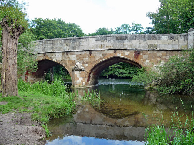
Lily Pond, located in Norfolk, is a picturesque freshwater marsh that offers a serene and tranquil environment for visitors to immerse themselves in nature. Spanning across an area of approximately 10 acres, this idyllic pond is known for its abundant vegetation and diverse wildlife.

The pond itself is surrounded by lush greenery, including tall reeds, water lilies, and cattails that create a stunning backdrop against the still waters. The vegetation not only adds to the aesthetic beauty of the pond but also provides a habitat for various species of birds, insects, and amphibians.

Lily Pond is home to a rich and diverse ecosystem. Visitors can spot a wide array of bird species, including herons, swans, ducks, and geese, either gliding gracefully across the water or nesting along the pond's edge. The pond also serves as a breeding ground for several species of fish, such as carp and perch, which can be observed in the clear waters.

Surrounding the pond, there are walking trails and benches, allowing visitors to explore the area at their own pace and enjoy the peaceful ambiance. The well-maintained paths provide easy access to different parts of the pond, allowing visitors to observe the wildlife up close.

Lily Pond is a popular spot for nature enthusiasts, bird watchers, and photographers. Its natural beauty and serene atmosphere make it an ideal location for relaxation and a perfect escape from the hustle and bustle of city life. Whether visitors are seeking solitude or a chance to observe wildlife, Lily Pond offers a delightful experience for all.

If you have any feedback on the listing, please let us know in the comments section below.

Lily Pond Images

Images are sourced within 2km of 52.61985/1.2571641 or Grid Reference TG2007. Thanks to Geograph Open Source API. All images are credited.

Goodwood Steps, UEA campus Anthony Caro sculpture which sits well with the stepped nature of the campus buildings behind.
Goodwood Steps, UEA campus
Anthony Caro sculpture which sits well with the stepped nature of the campus buildings behind.
Suffolk Terrace (ziggurats), University of East Anglia
Sainsbury Centre, University of East Anglia
Footbridge leading into the Sainsbury Centre, University of East Anglia The Sainsbury Centre at the University of East Anglia is a renowned art gallery, housed in a pioneering example by Norman Foster of high-tech architecture.
Footbridge leading into the Sainsbury Centre, University of East Anglia
The Sainsbury Centre at the University of East Anglia is a renowned art gallery, housed in a pioneering example by Norman Foster of high-tech architecture.
Bridge, Cringleford Built in 1520, replacing a bridge washed away in 1519, and widened in 1780. The facings are in limestone, "a rarity in Norfolk other than for churches and bridges". Grade II* listed.
It carries Eaton Street over the River Yare.
Bridge, Cringleford
Built in 1520, replacing a bridge washed away in 1519, and widened in 1780. The facings are in limestone, "a rarity in Norfolk other than for churches and bridges". Grade II* listed. It carries Eaton Street over the River Yare.
Cringleford: Haldane Drive
Cringleford: Barratt Homes 'Cringleford Heights' site and sales office
UEA: Lasdun's Teaching Wall The Teaching Wall in 2014 prior to redevelopment.  This is a 450m-long, six-storey block at the University of East Anglia - arranged as a single long spine.  Designed by architect Denys Lasdun (1964-8).  

Lasdun "...hugged the lines of the contours with long, narrow buildings which also achieved a vertical segregation, with pedestrians on an upper walkway system and vehicles on the ground below. The walkways resemble a street, with the teaching facilities to one side and the residential blocks on the other, slung between the entrance square of communal buildings at one end..."
Elain Harwood, 4 Jan 2010, bdonline <span class="nowrap"><a title="https://www.bdonline.co.uk/revisiting-denys-lasduns-uea/5010945.article" rel="nofollow ugc noopener" href="https://www.bdonline.co.uk/revisiting-denys-lasduns-uea/5010945.article">Link</a><img style="margin-left:2px;" alt="External link" title="External link - shift click to open in new window" src="https://s1.geograph.org.uk/img/external.png" width="10" height="10"/></span>

The building was designed to be repurposed internally as needs changed.  In 2022 UEA announced its intention to refurbish and reimagine the Teaching Wall for the 21st century.  The renewed building will have two floors of modern teaching space and four floors of laboratory space and learning facilities.
News: <span class="nowrap"><a title="https://www.uea.ac.uk/news/-/article/the-lasdun-wall-refurbishment-project" rel="nofollow ugc noopener" href="https://www.uea.ac.uk/news/-/article/the-lasdun-wall-refurbishment-project">Link</a><img style="margin-left:2px;" alt="External link" title="External link - shift click to open in new window" src="https://s1.geograph.org.uk/img/external.png" width="10" height="10"/></span>
Project: <span class="nowrap"><a title="https://www.uea.ac.uk/about/university-information/campus-and-community/campus-investment/lasdun-wall-development" rel="nofollow ugc noopener" href="https://www.uea.ac.uk/about/university-information/campus-and-community/campus-investment/lasdun-wall-development">Link</a><img style="margin-left:2px;" alt="External link" title="External link - shift click to open in new window" src="https://s1.geograph.org.uk/img/external.png" width="10" height="10"/></span>

Grade II listed (English Heritage): <span class="nowrap"><a title="https://historicengland.org.uk/listing/the-list/list-entry/1390648" rel="nofollow ugc noopener" href="https://historicengland.org.uk/listing/the-list/list-entry/1390648">Link</a><img style="margin-left:2px;" alt="External link" title="External link - shift click to open in new window" src="https://s1.geograph.org.uk/img/external.png" width="10" height="10"/></span>

The University of East Anglia was founded in 1960, and Lasdun was commissioned as consultant architect in April 1962. The site is on 165 acres of parkland on the edge of Norwich.
UEA: Lasdun's Teaching Wall
The Teaching Wall in 2014 prior to redevelopment. This is a 450m-long, six-storey block at the University of East Anglia - arranged as a single long spine. Designed by architect Denys Lasdun (1964-8). Lasdun "...hugged the lines of the contours with long, narrow buildings which also achieved a vertical segregation, with pedestrians on an upper walkway system and vehicles on the ground below. The walkways resemble a street, with the teaching facilities to one side and the residential blocks on the other, slung between the entrance square of communal buildings at one end..." Elain Harwood, 4 Jan 2010, bdonline LinkExternal link The building was designed to be repurposed internally as needs changed. In 2022 UEA announced its intention to refurbish and reimagine the Teaching Wall for the 21st century. The renewed building will have two floors of modern teaching space and four floors of laboratory space and learning facilities. News: LinkExternal link Project: LinkExternal link Grade II listed (English Heritage): LinkExternal link The University of East Anglia was founded in 1960, and Lasdun was commissioned as consultant architect in April 1962. The site is on 165 acres of parkland on the edge of Norwich.
UEA: Lasdun's Ziggurats The University of East Anglia's architecturally remarkable grade II-listed Ziggurats,  Norfolk and Suffolk Terrace, were designed by Denys Lasdun (1964-8).  Internally updated, they provide on campus student accommodation.  

Grade II listed: <span class="nowrap"><a title="https://historicengland.org.uk/listing/the-list/list-entry/1390647" rel="nofollow ugc noopener" href="https://historicengland.org.uk/listing/the-list/list-entry/1390647">Link</a><img style="margin-left:2px;" alt="External link" title="External link - shift click to open in new window" src="https://s1.geograph.org.uk/img/external.png" width="10" height="10"/></span>

The University of East Anglia was founded in 1960, and Lasdun was commissioned as consultant architect in April 1962. The site is on 165 acres of parkland on the edge of Norwich.
UEA: Lasdun's Ziggurats
The University of East Anglia's architecturally remarkable grade II-listed Ziggurats, Norfolk and Suffolk Terrace, were designed by Denys Lasdun (1964-8). Internally updated, they provide on campus student accommodation. Grade II listed: LinkExternal link The University of East Anglia was founded in 1960, and Lasdun was commissioned as consultant architect in April 1962. The site is on 165 acres of parkland on the edge of Norwich.
Unthank Road, Norwich A close-up of the post box can be seen in <a href="https://www.geograph.org.uk/photo/7000311">TG2208 : Post box, Clarendon Road, Norwich</a>.
Unthank Road, Norwich
A close-up of the post box can be seen in TG2208 : Post box, Clarendon Road, Norwich.
Post box, Clarendon Road, Norwich This post box can be seen in context in <a href="https://www.geograph.org.uk/photo/7000309">TG2208 : Unthank Road, Norwich</a>.
Post box, Clarendon Road, Norwich
This post box can be seen in context in TG2208 : Unthank Road, Norwich.
Grosvenor Road, Norwich
Post box, Unthank Road, Norwich This post baxk can be seen in context in <a href="https://www.geograph.org.uk/photo/7000343">TG2108 : Unthank Road, Norwich</a>.
Post box, Unthank Road, Norwich
This post baxk can be seen in context in TG2108 : Unthank Road, Norwich.
Unthank Road, Norwich A close-up of the post box can be seen in <a href="https://www.geograph.org.uk/photo/7000342">TG2108 : Post box, Unthank Road, Norwich</a>.
Unthank Road, Norwich
A close-up of the post box can be seen in TG2108 : Post box, Unthank Road, Norwich.
The Amnesty Bookshop, Unthank Road, Norwich Dover street and Onley Street join Unthank Road at this point.
The Amnesty Bookshop, Unthank Road, Norwich
Dover street and Onley Street join Unthank Road at this point.
The junction of Unthank Road and Bury Street, Norwich A close-up of the post box can be seen in <a href="https://www.geograph.org.uk/photo/7000347">TG2107 : Post box, Unthank Road, Norwich</a>.
The junction of Unthank Road and Bury Street, Norwich
A close-up of the post box can be seen in TG2107 : Post box, Unthank Road, Norwich.
Show me another place!

Lily Pond is located at Grid Ref: TG2007 (Lat: 52.61985, Lng: 1.2571641)

Administrative County: Norfolk

District: Norwich

Police Authority: Norfolk

What 3 Words

///zone.rail.loss. Near Cringleford, Norfolk

Nearby Locations

Lily Pond

Related Wikis

Eaton Park Miniature Railway

The Eaton Park Miniature Railway (EPMR) is situated in Eaton Park, in Norwich, Norfolk. Construction began in 1957 and the 365-foot (111 m) loop of elevated...

Eaton Park

Eaton Park is a large public park located in Eaton, Norwich, England.It is 80 acres in area. == History == The park was laid out in 1923 as part of a public...

Norwich South (UK Parliament constituency)

Norwich South is a constituency in Norfolk represented in the House of Commons of the Parliament of the United Kingdom, since 2015 by Clive Lewis, of the...

Eaton, Norfolk

Eaton is a suburb of the city of Norwich, in the Norwich district, in the county town of Norfolk, England. Anciently the superiority of manor of Eaton...

City Academy Norwich

City Academy Norwich is a secondary school in Norwich, England. It opened in September 2009, replacing Earlham High School. It is located near the University...

University of East Anglia

The University of East Anglia (UEA) is a public research university in Norwich, England. Established in 1963 on a 320-acre (130-hectare) campus west of...

UEA School of International Development

The School of International Development (formerly The School of Development Studies) is a department at the University of East Anglia, Norwich, England...

Eaton Chalk Pit

Eaton Chalk Pit is a 0.16-hectare (0.40-acre) biological Site of Special Scientific Interest on the southern outskirts of Norwich in Norfolk.These former...

Nearby Amenities

Located within 500m of 52.61985,1.2571641
Traffic Calming: hump
Lat/Long: 52.6200415/1.2498753
Traffic Signals
Lat/Long: 52.6212613/1.2640466
Crossing
Crossing: uncontrolled
Crossing Island: no
Tactile Paving: yes
Traffic Calming: table
Lat/Long: 52.6219669/1.256598
Crossing
Crossing: uncontrolled
Crossing Island: no
Tactile Paving: yes
Traffic Calming: table
Lat/Long: 52.6211628/1.2518665
Crossing
Crossing: marked
Crossing Island: yes
Tactile Paving: yes
Lat/Long: 52.6179737/1.2572864
Waste Basket
Lat/Long: 52.6185469/1.2584388
Waste Basket
Check Date: 2023-02-17
Lat/Long: 52.6190519/1.2594395
Waste Basket
Lat/Long: 52.6202316/1.2602143
Waste Basket
Lat/Long: 52.6206285/1.2609847
Waste Basket
Lat/Long: 52.6208484/1.2612111
Waste Basket
Lat/Long: 52.6208759/1.2621289
Waste Basket
Lat/Long: 52.6217212/1.2600294
Bicycle Parking
Bicycle Parking: stands
Capacity: 4
Covered: no
Lat/Long: 52.6217286/1.2600069
Waste Basket
Check Date: 2021-11-19
Lat/Long: 52.621297/1.2600571
Waste Basket
Lat/Long: 52.6212513/1.2604905
Barrier: bollard
Lat/Long: 52.6206911/1.2603418
Waste Basket
Lat/Long: 52.6216003/1.2592638
Waste Basket
Check Date: 2021-11-19
Lat/Long: 52.6205409/1.2580792
Waste Basket
Lat/Long: 52.6209405/1.2570665
Waste Basket
Lat/Long: 52.6214635/1.2568314
Bicycle Parking
Check Date: 2022-09-10
Covered: no
Lat/Long: 52.621652/1.2568876
Waste Basket
Lat/Long: 52.621918/1.2566389
Information: board
Operator: Friends of Eaton Park
Tourism: information
Lat/Long: 52.6217053/1.2599051
Give Way
Lat/Long: 52.6222512/1.2619157
Turning Circle
Lat/Long: 52.6230429/1.2536701
Barrier: bollard
Lat/Long: 52.6226009/1.2535015
Barrier: bollard
Lat/Long: 52.6226741/1.2543481
Post Box
Collection Times: Mo-Fr 18:05; Sa 11:00
Operator: Royal Mail
Postal Code: NR4
Ref: NR4 429
Lat/Long: 52.6220131/1.2564064
Waste Basket
Check Date: 2022-12-03
Lat/Long: 52.6208551/1.2633668
Bus Stop
Colman Road & The Farm House
Bench: yes
Bin: yes
Bus: yes
Lit: yes
Naptan AtcoCode: 2900N12425
Naptan Bearing: NW
Naptan CommonName: South Park Avenue
Naptan Indicator: opp
Naptan Landmark: Farmhouse Public House
Naptan Locality: Norwich
Naptan NaptanCode: nfodjtjm
Naptan PlusbusZoneRef: NRCH
Naptan Street: Colman Road
Operator: Anglian Coaches Ltd.
Public Transport: platform
Shelter: yes
Source: naptan_import;survey
Tactile Paving: yes
Lat/Long: 52.6215774/1.2634042
Waste Basket
Colour: green
Material: plastic
Lat/Long: 52.6220789/1.262293
Post Box
Collection Times: Mo-Fr 17:00; Sa 12:30
Indoor: yes
Note: Custom rectangular wooden box
Operator: Royal Mail
Post Box Type: pillar
Ref: NR4 446
Royal Cypher: no
Lat/Long: 52.6217147/1.2625157
Waste Basket
Colour: green
Material: plastic
Lat/Long: 52.621852/1.2511616
Post Box
Collection Times: Mo-Fr 09:00; Sa 07:00
Operator: Royal Mail
Post Box Design: type_b
Post Box Type: pillar
Postal Code: NR4
Ref: NR4 425D
Royal Cypher: EIIR
Royal Cypher Wikidata: Q33102113
Lat/Long: 52.6218367/1.2511605
Bus Stop
Pettus Road opp / Norgate Road
Naptan AtcoCode: 2900N12684
Naptan Bearing: N
Naptan CommonName: Norgate Road
Naptan Indicator: opp
Naptan Landmark: Norgate Road
Naptan Locality: Eaton Park
Naptan NaptanCode: nfodmjwt
Naptan PlusbusZoneRef: NRCH
Naptan Street: Pettus Road
Operator: Anglian Coaches Ltd.
Ref: NFODMJWT
Shelter: no
Source: naptan_import;survey
Lat/Long: 52.6167809/1.2528097
Post Box
Collection Times: Mo-Fr 09:00; Sa 07:00
Operator: Royal Mail
Post Box Type: lamp
Ref: NR4 426D
Royal Cypher: EIIR
Royal Cypher Wikidata: Q33102113
Lat/Long: 52.6158419/1.2550996
Bus Stop
Pettus Road / opp Norgate Road
Naptan AtcoCode: 2900N12687
Naptan Bearing: SW
Naptan CommonName: Ryrie Court
Naptan Indicator: adj
Naptan Landmark: Ryrie Court
Naptan Locality: Eaton Park
Naptan NaptanCode: nfodmpaj
Naptan PlusbusZoneRef: NRCH
Naptan Street: Pettus Road
Operator: Anglian Coaches Ltd.
Shelter: no
Source: naptan_import;survey
Lat/Long: 52.6166212/1.2557228
Bus Stop
South Park Avenue / Custance Court
Bench: yes
Bin: yes
Check Date Shelter: 2023-02-17
Naptan AtcoCode: 2900N12420
Naptan Bearing: NE
Naptan BusStopType: CUS
Naptan CommonName: Custance Court
Naptan Indicator: opp
Naptan Landmark: Custance Court
Naptan Locality: Eaton Park
Naptan NaptanCode: nfodjtgt
Naptan PlusbusZoneRef: NRCH
Naptan Street: South Park Avenue
Operator: First Eastern Counties
Ref: NFODJTGT
Shelter: yes
Source: naptan_import;survey
Tactile Paving: no
Lat/Long: 52.6178097/1.2515177
Post Box
Check Date Collection Times: 2022-12-03
Collection Times: Mo-Fr 09:00; Sa 07:00
Operator: Royal Mail
Post Box Type: pillar
Ref: NR4 427D
Royal Cypher: GVIR
Royal Cypher Wikidata: Q33102169
Lat/Long: 52.6198612/1.2611103
Eaton Park Miniature Railway
Crossing: uncontrolled
Crossing Barrier: no
Railway: crossing
Lat/Long: 52.6195376/1.259685
Eaton Park Miniature Railway
Crossing: uncontrolled
Crossing Barrier: no
Railway: crossing
Lat/Long: 52.6193385/1.2597204
Eaton Park Miniature Railway
Crossing: uncontrolled
Crossing Barrier: no
Railway: crossing
Lat/Long: 52.619564/1.2602119
Bench
Backrest: yes
Lat/Long: 52.6207729/1.2608884
Bench
Backrest: yes
Lat/Long: 52.6208162/1.2609223
Bench
Backrest: yes
Lat/Long: 52.6208704/1.2610442
Bench
Backrest: yes
Lat/Long: 52.6208758/1.2611173
Bench
Backrest: yes
Lat/Long: 52.6208353/1.2612531
Bench
Backrest: yes
Lat/Long: 52.620797/1.2612935
Bench
Backrest: yes
Lat/Long: 52.6207112/1.2613112
Bench
Backrest: yes
Lat/Long: 52.6206675/1.2612812
Bench
Backrest: yes
Lat/Long: 52.6206145/1.2611618
Bench
Backrest: yes
Lat/Long: 52.6206098/1.2610889
Bench
Backrest: yes
Lat/Long: 52.6206446/1.2609561
Bench
Backrest: yes
Lat/Long: 52.6206837/1.2609096
Eaton Park Miniature Railway
Crossing: uncontrolled
Crossing Barrier: no
Railway: crossing
Lat/Long: 52.6195741/1.2602228
Railway: turntable
Lat/Long: 52.6198789/1.2606333
Recycling
Farmhouse PH, Colman Road
Recycling Cans: yes
Recycling Glass Bottles: yes
Url: http://www.norwich.gov.uk/intranet_docs/A-Z/Recycling/Recycling_Centres.pdf
Lat/Long: 52.6211246/1.2627625
Crossing
Button Operated: yes
Crossing: traffic_signals
Crossing Island: no
Crossing Ref: puffin
Tactile Paving: yes
Traffic Signals Sound: yes
Lat/Long: 52.6222643/1.2624956
Bus Stop
Colman Road / G. Borrows Rd
Bench: no
Bin: no
Bus: yes
Lit: no
Naptan AtcoCode: 2900N12208
Naptan Bearing: NW
Naptan CommonName: Jessop Road
Naptan Indicator: opp
Naptan Landmark: George Borrow Road
Naptan Locality: Norwich
Naptan NaptanCode: nfodjawa
Naptan PlusbusZoneRef: NRCH
Naptan Street: Colman Road
Operator: Anglian Coaches Ltd.
Public Transport: platform
Shelter: no
Source: naptan_import;survey
Tactile Paving: yes
Lat/Long: 52.6227445/1.2615129
Bus Stop
Colman Road & Jessop Road
Bench: no
Bin: no
Bus: yes
Lit: yes
Naptan AtcoCode: 2900N1223
Naptan Bearing: SE
Naptan CommonName: Jessop Road
Naptan Indicator: adj
Naptan Landmark: Jessop Road
Naptan Locality: Norwich
Naptan NaptanCode: nfodjdjm
Naptan PlusbusZoneRef: NRCH
Naptan Street: Colman Road
Operator: Anglian Coaches Ltd.
Public Transport: platform
Shelter: no
Source: naptan_import;survey
Tactile Paving: yes
Lat/Long: 52.6227221/1.2618214
Bus Stop
South Park Avenue / opp Pettus Road
Bench: yes
Bin: yes
Lit: yes
Naptan AtcoCode: 2900N12277
Naptan Bearing: E
Naptan BusStopType: CUS
Naptan CommonName: Pettus Road
Naptan Indicator: opp
Naptan Landmark: Pettus Road
Naptan Locality: Eaton Park
Naptan NaptanCode: nfodjgjt
Naptan PlusbusZoneRef: NRCH
Naptan Street: South Park Avenue
Operator: First Eastern Counties;Anglian Coaches Ltd.
Shelter: yes
Source: naptan_import;survey
Tactile Paving: no
Lat/Long: 52.6181087/1.2568107
Bus Stop
South Park Avenue / Pettus Road
Bench: no
Bin: no
Check Date Shelter: 2023-02-17
Lit: no
Naptan AtcoCode: 2900N12278
Naptan Bearing: W
Naptan BusStopType: CUS
Naptan CommonName: Pettus Road
Naptan Indicator: adj
Naptan Landmark: Pettus Road
Naptan Locality: Eaton Park
Naptan NaptanCode: nfodjgjw
Naptan PlusbusZoneRef: NRCH
Naptan Street: South Park Avenue
Operator: First Eastern Counties
Shelter: no
Source: naptan_import;survey
Tactile Paving: no
Lat/Long: 52.6181072/1.2559114
Bus Stop
Northfields Eaton
Naptan AtcoCode: 2900N12397
Naptan Bearing: W
Naptan BusStopType: CUS
Naptan CommonName: no 186
Naptan Indicator: adj
Naptan Landmark: No. 186 Northfields
Naptan Latitude: 52.6227981
Naptan Locality: Northfields
Naptan Longitude: 1.25492
Naptan NaptanCode: nfodjpwg
Naptan PlusbusZoneRef: NRCH
Naptan Street: Northfields
Operator: First Eastern Counties
Shelter: no
Source: naptan_import;survey
Lat/Long: 52.6227584/1.2547317
Bus Stop
George Borrow Road
Bench: no
Bin: no
Check Date Shelter: 2022-08-04
Lit: yes
Naptan AtcoCode: 2900N12399
Naptan Bearing: S
Naptan BusStopType: CUS
Naptan CommonName: No 103
Naptan Indicator: adj
Naptan Landmark: No. 103
Naptan Locality: Northfields
Naptan NaptanCode: nfodjpwm
Naptan PlusbusZoneRef: NRCH
Naptan Street: George Borrow Road
Operator: First Eastern Counties
Shelter: no
Source: naptan_import;survey
Tactile Paving: yes
Lat/Long: 52.6240782/1.2574568
Middle School
Naptan AtcoCode: 2900N12415
Naptan Bearing: SW
Naptan BusStopType: CUS
Naptan CommonName: Middle School
Naptan Indicator: adj
Naptan Landmark: Middle School
Naptan Locality: Eaton Park
Naptan NaptanCode: nfodjtga
Naptan PlusbusZoneRef: NRCH
Naptan Street: South Park Avenue
Physically Present: no
Source: naptan_import;survey
Lat/Long: 52.6208172/1.2631668
Bus Stop
Norwich / South Park Avenue
Bench: no
Bin: no
Check Date Shelter: 2022-12-03
Lit: yes
Naptan AtcoCode: 2900N12416
Naptan Bearing: NE
Naptan CommonName: Middle School
Naptan Indicator: opp
Naptan Landmark: Middle School
Naptan Latitude: 52.6207474
Naptan Locality: Eaton Park
Naptan Longitude: 1.2627626
Naptan NaptanCode: nfodjtgd
Naptan PlusbusZoneRef: NRCH
Naptan Street: South Park Avenue
Operator: First Eastern Counties
Shelter: no
Source: naptan_import;survey
Tactile Paving: yes
Lat/Long: 52.620352/1.2619236
Bus Stop
South Park Avenue / Buckingham Road
Bench: no
Bin: yes
Check Date Shelter: 2022-12-03
Lit: no
Naptan AtcoCode: 2900N12417
Naptan Bearing: SW
Naptan CommonName: No 1
Naptan Indicator: adj
Naptan Latitude: 52.6195943
Naptan Locality: Eaton Park
Naptan Longitude: 1.2605488
Naptan NaptanCode: nfodjtgj
Naptan PlusbusZoneRef: NRCH
Naptan Street: South Park Avenue
Operator: First Eastern Counties
Shelter: no
Source: naptan_import;survey
Tactile Paving: yes
Lat/Long: 52.6195189/1.2604207
South Park Avenue / opp Buckingham Road
Naptan AtcoCode: 2900N12418
Naptan Bearing: NE
Naptan BusStopType: CUS
Naptan CommonName: No 1
Naptan Indicator: opp
Naptan Locality: Eaton Park
Naptan NaptanCode: nfodjtgm
Naptan PlusbusZoneRef: NRCH
Naptan Street: South Park Avenue
Operator: First Eastern Counties
Physically Present: no
Shelter: no
Source: naptan_import;survey
Lat/Long: 52.6195988/1.2603866
Bus Stop
South Park Avenue / Custance Court
Bench: yes
Bin: no
Check Date Shelter: 2023-02-17
Naptan AtcoCode: 2900N12419
Naptan Bearing: SW
Naptan BusStopType: CUS
Naptan CommonName: Custance Court
Naptan Indicator: adj
Naptan Landmark: Custance Court
Naptan Latitude: 52.6176946
Naptan Locality: Eaton Park
Naptan Longitude: 1.2511424
Naptan NaptanCode: nfodjtgp
Naptan PlusbusZoneRef: NRCH
Naptan Street: South Park Avenue
Operator: First Eastern Counties
Ref: NFODJTGP
Shelter: yes
Source: naptan_import;survey
Tactile Paving: no
Lat/Long: 52.6175909/1.2509694
Bus Stop
Pettus Road / Norgate Road
Naptan AtcoCode: 2900N12685
Naptan Bearing: SW
Naptan CommonName: Norgate Road
Naptan Indicator: adj
Naptan Landmark: Norgate Road
Naptan Latitude: 52.6170691
Naptan Locality: Eaton Park
Naptan Longitude: 1.2529578
Naptan NaptanCode: nfodmpad
Naptan PlusbusZoneRef: NRCH
Naptan Street: Pettus Road
Note: Bearing should be S
Operator: Anglian Coaches Ltd.
Ref: NFODMPAD
Shelter: no
Source: naptan_import;survey
Lat/Long: 52.6169248/1.2529152
Bus Stop
Pettus Road / opp Buckingham Rd
Bench: no
Bin: no
Check Date Shelter: 2023-02-17
Naptan AtcoCode: 2900N12686
Naptan Bearing: NE
Naptan CommonName: Buckingham Road
Naptan Indicator: opp
Naptan Landmark: Buckingham Road
Naptan Locality: Eaton Park
Naptan NaptanCode: nfodmpag
Naptan PlusbusZoneRef: NRCH
Naptan Street: Pettus Road
Operator: Anglian Coaches Ltd.
Shelter: no
Source: naptan_import;survey
Tactile Paving: no
Lat/Long: 52.617586/1.2561592
Bus Stop
Pettus Road / Norgate Road
Naptan AtcoCode: 2900N12688
Naptan Bearing: NE
Naptan CommonName: Ryrie Court
Naptan Indicator: opp
Naptan Landmark: Ryrie Court
Naptan Latitude: 52.6164004
Naptan Locality: Eaton Park
Naptan Longitude: 1.2553611
Naptan NaptanCode: nfodmpam
Naptan PlusbusZoneRef: NRCH
Naptan Street: Pettus Road
Operator: Anglian Coaches Ltd.
Shelter: no
Source: naptan_import;survey
Lat/Long: 52.6164413/1.2555
Bus Stop
North Park Ave / De Hague Road
Naptan AtcoCode: 2900N12720
Naptan Bearing: E
Naptan BusStopType: CUS
Naptan CommonName: De Hague Road
Naptan Indicator: adj
Naptan Landmark: De Hague Road
Naptan Latitude: 52.6219552
Naptan Locality: Northfields
Naptan Longitude: 1.2545027
Naptan NaptanCode: nfodmptg
Naptan PlusbusZoneRef: NRCH
Naptan Street: North Park Avenue
Operator: First Eastern Counties
Physically Present: no
Source: naptan_import;survey
Lat/Long: 52.6220133/1.2565313
Eaton Park CCTV Camera
Man Made: surveillance
Note: Permanent CCTV camera. Forward Vision MIC1-400 with Dual Infrared Illuminators.
Surveillance: public
Url: http://sites.google.com/site/norwichpolicecctv/
Lat/Long: 52.618496/1.257732
Check Date: 2021-11-19
Traffic Calming: bump
Lat/Long: 52.6182627/1.2529634
Man Made: surveillance
Surveillance: public
Lat/Long: 52.618598/1.2529625
Check Date: 2021-11-19
Traffic Calming: bump
Lat/Long: 52.6184985/1.2529186
Check Date: 2021-11-19
Traffic Calming: bump
Lat/Long: 52.618372/1.2529423
Man Made: serving_area_interface
Operator: BT
Lat/Long: 52.6168503/1.2529328
Waste Basket
Colour: green
Material: plastic
Lat/Long: 52.6180911/1.2569334
Waste Basket
Colour: green
Material: plastic
Lat/Long: 52.6177935/1.2514542
Man Made: service_area_interface
Operator: BT
Lat/Long: 52.6174966/1.2562983
Waste Basket
Check Date: 2022-12-03
Lat/Long: 52.6195257/1.26042
Bus Stop
George Borrow Road
Bench: no
Bin: no
Bus: yes
Lit: yes
Naptan AtcoCode: 2900N123104
Naptan NaptanCode: NFOGTMTJ
Note: Sign remains (twisted) but 35 route no longer exists, so presumed to serve 25A
Operator: First
Public Transport: platform
Route Ref: 35
Shelter: no
Source: survey;photo
Tactile Paving: yes
Lat/Long: 52.6232733/1.2590733
Crossing
Crossing: unmarked
Lat/Long: 52.6209943/1.2511617
Crossing
Crossing: unmarked
Lat/Long: 52.6219806/1.2550486
Turning Circle
Lat/Long: 52.6204045/1.2645114
Barrier: bollard
Lat/Long: 52.6232623/1.261148
Defibrillator
Addr Postcode: NR4 7EE
Defibrillator Location: On wall of Rotunda in Eaton Park, facing inwards towards the bandstand.
Emergency: defibrillator
Indoor: no
Ref: 17-1538
Ref GB The Circuit: 2339A2AE-3B10-4523-905D-B00A00FB320D
Lat/Long: 52.6204153/1.2567228
Bench
Backrest: yes
Description: No 1. Needs replacing.
Material: wood
Lat/Long: 52.6211629/1.2614155
Bench
Backrest: no
Description: No. 3. Designed and made by Andrew Smith.
Material: Wood_and_steel
Lat/Long: 52.6199712/1.2603098
Crossing
Crossing: unmarked
Crossing Island: no
Tactile Paving: yes
Lat/Long: 52.6231424/1.2608887
Give Way
Lat/Long: 52.6231685/1.2609598
Bicycle Parking
Bicycle Parking: stands
Capacity: 4
Covered: no
Lat/Long: 52.6217285/1.2599078
Telephone
Booth: KX100
Check Date: 2021-11-07
Covered: booth
Lat/Long: 52.6218134/1.2628976
Crossing
Button Operated: yes
Crossing: traffic_signals
Crossing Island: yes
Crossing Ref: pelican
Tactile Paving: yes
Lat/Long: 52.6211807/1.2639359
Crossing
Crossing: uncontrolled
Crossing Island: yes
Tactile Paving: yes
Lat/Long: 52.6213505/1.2638889
Crossing
Crossing: unmarked
Crossing Island: yes
Lat/Long: 52.6232486/1.2609834
Crossing
Crossing: uncontrolled
Crossing Island: no
Crossing Ref: zebra
Tactile Paving: yes
Lat/Long: 52.6205144/1.2623977
Barrier: kerb
Kerb: lowered
Tactile Paving: yes
Lat/Long: 52.6211082/1.2640626
Barrier: kerb
Kerb: lowered
Tactile Paving: yes
Lat/Long: 52.621097/1.2642788
Barrier: kerb
Kerb: flush
Tactile Paving: yes
Lat/Long: 52.6213949/1.2639633
Barrier: kerb
Kerb: lowered
Tactile Paving: yes
Lat/Long: 52.6222287/1.262421
Crossing
Crossing: unmarked
Crossing Island: no
Tactile Paving: no
Lat/Long: 52.6223591/1.2620465
Crossing
Crossing: unmarked
Crossing Island: no
Tactile Paving: no
Lat/Long: 52.6225557/1.2622348
Traffic Calming: island
Lat/Long: 52.6226206/1.2619209
Fountain
Artwork Type: mosaic
Note: Domed fountain. Dome covered with varied tiles.
Tourism: artwork
Lat/Long: 52.620761/1.2610963
Grit Bin
Lat/Long: 52.6219411/1.2608208
Grit Bin
Lat/Long: 52.6221214/1.2519522
Grit Bin
Lat/Long: 52.6235752/1.2577505
Cafe
Eaton Park Café
Addr City: Norwich
Addr Parentstreet: South Park Avenue
Addr Place: Eaton Park
Addr Postcode: NR4 7AU
Addr Substreet: Eaton Park
Fhrs Id: 878419
Opening Hours: PH,Mo-Su 09:00-16:00
Source Addr: FHRS Open Data
Url: http://friendsofeatonpark.co.uk/cafe/
Lat/Long: 52.6203406/1.2574479
Barrier: bollard
Lat/Long: 52.616315/1.2603799
Atm
Check Date: 2022-08-05
Lat/Long: 52.6217664/1.2627249
Disused Shop: car
Lat/Long: 52.622246/1.262234
Post Office
Colman Road Post Office
Addr City: Norwich
Addr Housenumber: 78-80
Addr Postcode: NR4 7EH
Addr Street: Colman Road
Brand: Post Office
Brand Wikidata: Q1783168
Indoor: yes
Opening Hours: Mo-Su 06:00-22:00
Ref Pol Id: 140565
Source Addr: pol_branch_list_2018-01
Source Opening Hours: pol_branch_list_2018-02
Start Date: 2016-11-01T13:00Z
Website: https://www.postoffice.co.uk/branch-finder/5601363/colman-road
Lat/Long: 52.6216911/1.2624812
Give Way
Lat/Long: 52.6234182/1.2576437
Give Way
Lat/Long: 52.6234817/1.2577256
Give Way
Lat/Long: 52.6213131/1.2504938
Give Way
Lat/Long: 52.6213493/1.2505495
Give Way
Lat/Long: 52.6186516/1.2610679
Give Way
Lat/Long: 52.6186903/1.2610029
Give Way
Lat/Long: 52.6181372/1.2602527
Give Way
Lat/Long: 52.618177/1.2601869
Crossing
Crossing: unmarked
Lat/Long: 52.6163926/1.2618897
Bench
Backrest: yes
Description: No. 19. Cavendish bench from Streetmaster. Installed 2019
Inscription: Kath and Vic - so many happy Sundays!
Material: wood
Seats: 1
Lat/Long: 52.6189689/1.2575873
Bench
Backrest: yes
Description: No. 18. Cavendish bench from Streetmaster. Installed by Friends of Eaton Park 2015
Inscription: Captain A E Sandys Winsch (1888-1964)
Material: wood
Seats: 1
Lat/Long: 52.6187923/1.2576415
Bench
Backrest: yes
Description: No. 17. Cavendish bench from Streetmaster. Installed 2016 by park staff.
Inscription: In loving memory of Alan Brown who worked on this park for 45 years
Material: wood
Lat/Long: 52.6186086/1.2576361
Bench
Backrest: yes
Description: No. 20. Cavendish, Street Master. Installed by Friends of Eaton Park in 2015
Inscription: In celebration of Eaton Park's Green Flag Award 2014.
Material: wood
Seats: 1
Lat/Long: 52.6192168/1.2575446
Bench: yes
Covered: no
Leisure: picnic_table
Lit: no
Material: wood
Lat/Long: 52.621543/1.2583298
Give Way
Lat/Long: 52.6225288/1.2621912
Give Way
Lat/Long: 52.6224229/1.2621624
Traffic Calming: hump
Lat/Long: 52.6238817/1.2574799
Bench;waste Basket
Backrest: yes
Material: wood
Seats: 3
Lat/Long: 52.6196446/1.2570535
Entrance: main
Lat/Long: 52.6200613/1.2580438
Entrance: main
Lat/Long: 52.6201311/1.2580307
iFix
Addr City: Norwich
Addr Country: GB
Addr Housenumber: 39
Addr Postcode: NR4 7BU
Addr Street: Pettus Road
Mobile Phone Repair: yes
Opening Hours: Mo-Fr 08:00-20:00, Sa-Su 09:00-16:00
Website: https://www.ifixnorwich.com/
Lat/Long: 52.6165059/1.2557828
Bench
Backrest: yes
Description: No. 2. Needs replacing.
Material: wood
Lat/Long: 52.6204123/1.2615189
Bicycle Rental
South Park Avenue
Bicycle Rental: docking_station
Capacity: 6
Email: support@beryl.cc
Fee: yes
Name Signed: no
Network: Beryl - Norwich
Official Name: South Park Avenue
Operator: Beryl
Operator Wikidata: Q106575369
Payment App: yes
Payment App Android: cc.beryl.basis
Payment App Ios: 1386768364
Payment Cash: no
Payment Credit Cards: no
Payment Cryptocurrencies: no
Payment Debit Cards: no
Payment Electronic Purses: no
Phone: +44 20 3003 5044
Ref Gbfs: beryl_norwich:2098
Rental: city_bike;ebike;escooter
Website: https://beryl.cc/scheme/norwich
Lat/Long: 52.6205025/1.26239
Waste Basket
Lat/Long: 52.6217333/1.2512552
Entrance: main
Lat/Long: 52.6217436/1.2512752
Tourism: picnic_site
Lat/Long: 52.6216143/1.2585236
Bench
Backrest: yes
Description: Furnitube. Installed @ 2013
Material: metal_and_plastic
Lat/Long: 52.6204786/1.2580961
Bench
Backrest: yes
Description: Furnitube. Installed @ 2013.
Material: Metal_and_plastic
Seats: 1
Lat/Long: 52.6205351/1.2582919
Bench
Backrest: no
Description: No. 5. Designed and built by Andrew Smith.
Material: Wood_and_steel
Seats: 1
Lat/Long: 52.6195928/1.2599414
Bench
Backrest: no
Description: No. 4. Designed and built by Andrew Smith.
Material: Wood_and_steel
Seats: 1
Lat/Long: 52.6196371/1.2598194
Bench
Backrest: yes
Description: No 10
Inscription: In memory of Mick Banks 1944-2008
Material: wood
Seats: 1
Lat/Long: 52.6213214/1.2593749
Bench
Backrest: yes
Description: No. 9.
Inscription: Loving Memory of Ben Parkin 1988-2013 - OTBC
Material: wood
Seats: 1
Lat/Long: 52.6210071/1.259439
Bench
Backrest: yes
Description: No 8. Installed 2015.
Inscription: From the Frostics
Material: wood
Seats: 1
Lat/Long: 52.6203731/1.2595536
Bench
Backrest: yes
Description: No. 7. Installed 2018.
Inscription: Happy memories of Bill and Valerie Hutchins - our dear mum and dad
Material: wood
Seats: 1
Lat/Long: 52.6201444/1.2595889
Bench
Backrest: yes
Description: No. 6. Older bench. Good condition.
Material: wood
Seats: 1
Lat/Long: 52.6199231/1.2596231
Bicycle Parking
Bicycle Parking: stands
Capacity: 12
Covered: no
Lat/Long: 52.6192064/1.2535105
Bench
Backrest: yes
Colour: red
Description: No. 45
Material: metal
Seats: 1
Lat/Long: 52.6219039/1.2575454
Bench
Backrest: yes
Colour: red
Material: metal
Seats: 1
Lat/Long: 52.6218976/1.2589177
Backrest: yes
Colour: No. 37
Description: 3 x dark metal picnic tables
Material: metal
Seats: 1
Tourism: picnic_site
Lat/Long: 52.6218869/1.2591499
Description: No. 59. One recycled plastic picnic table. Installed 2019 by Friends of Eaton Park.
Tourism: picnic_site
Lat/Long: 52.6191939/1.2536702
Bench
Backrest: yes
Description: No. 60. Second hand bench brought to park from previous location by Norwich City Council.
Material: wood_and_metal
Seats: 1
Lat/Long: 52.6191885/1.2538723
Bench
Backrest: yes
Description: No. 61. Second hand bench brought to park from previous location by Norwich City Council.
Material: wood_and_metal
Seats: 1
Lat/Long: 52.6191965/1.2540304
Bench
Backrest: no
Description: No 58. Two half benches next to eachother.
Material: wood
Seats: 1
Lat/Long: 52.618868/1.2529029
Eaton Park Community Centre
Information: board
Tourism: information
Lat/Long: 52.6185537/1.2529364
Board Type: notice
Information: board
Operator: Friends of Eaton Park
Tourism: information
Lat/Long: 52.618076/1.2574222
Bench
Backrest: yes
Description: No. 16. Cavendish bench from Streetmaster. Installed by Friends of Eaton Park in 2015.
Inscription: In memory of hte local men who in the 1920's built Eaton Park
Material: wood
Seats: 1
Lat/Long: 52.6185083/1.2576552
Traffic Calming: hump
Lat/Long: 52.6219838/1.2584241
Traffic Calming: hump
Lat/Long: 52.6217459/1.2541173
Bench
Backrest: yes
Colour: brown
Direction: ESE
Inscription: Ellen’s Bench / Friends of Eaton Park / Spring 2021
Material: plastic;metal
Note: Funded by 89-year old Ellen Futter of Violet Elvin Court
Seats: 3
Surface: concrete
Lat/Long: 52.6216996/1.256747
Give Way
Lat/Long: 52.6220049/1.2568877
Bicycle Parking
Bicycle Parking: stands
Capacity: 8
Covered: no
Lat/Long: 52.6189014/1.2591023
Bicycle Parking
Bicycle Parking: stands
Capacity: 14
Covered: no
Lat/Long: 52.6201254/1.2577711
Waste Basket
Lat/Long: 52.620468/1.2565459
Waste Basket
Lat/Long: 52.620764/1.2624589
Waste Basket
Lat/Long: 52.6181572/1.2528882
Waste Basket
Lat/Long: 52.6216546/1.2587512
Waste Basket
Colour: green
Material: plastic
Lat/Long: 52.6175677/1.2588377
Waste Basket
Colour: green
Material: plastic
Lat/Long: 52.6203698/1.2622228
Waste Basket
Lat/Long: 52.6198175/1.2604401
Waste Basket
Lat/Long: 52.6202747/1.2518868
Waste Basket
Lat/Long: 52.6189175/1.253496
Waste Basket
Colour: green
Material: plastic
Lat/Long: 52.6218604/1.2625553
Waste Basket
Lat/Long: 52.6194051/1.2568555
Waste Basket
Lat/Long: 52.6200283/1.2512813
Waste Basket
Lat/Long: 52.621495/1.2602417
Waste Basket
Lat/Long: 52.6212974/1.2537574
Waste Basket
Lat/Long: 52.6191838/1.2532243
Waste Basket
Lat/Long: 52.6188988/1.2592094
Waste Basket
Colour: green
Material: plastic
Lat/Long: 52.6202866/1.2620148
Waste Basket
Lat/Long: 52.6202047/1.2524237
Waste Basket
Lat/Long: 52.6209494/1.2519921
Waste Basket
Lat/Long: 52.6182167/1.2576073
Waste Basket
Lat/Long: 52.6204411/1.2571687
Waste Basket
Colour: green
Material: plastic
Lat/Long: 52.617524/1.2589503
Waste Basket
Lat/Long: 52.6200521/1.2574165
Waste Basket
Colour: green
Material: plastic
Lat/Long: 52.621439/1.2635093
Waste Basket
Lat/Long: 52.6205587/1.258567
Waste Basket
Lat/Long: 52.6207291/1.2602193
Bicycle Parking
Bicycle Parking: stands
Capacity: 4
Covered: no
Lat/Long: 52.6218336/1.2629322
Give Way
Lat/Long: 52.6180545/1.2564664
Generator Method: photovoltaic
Generator Output Electricity: yes
Generator Source: solar
Generator Type: solar_photovoltaic_panel
Location: roof
Power: generator
Lat/Long: 52.6175212/1.2510855
Generator Method: photovoltaic
Generator Output Electricity: yes
Generator Source: solar
Generator Type: solar_photovoltaic_panel
Location: roof
Power: generator
Lat/Long: 52.6174658/1.2511767
Generator Method: photovoltaic
Generator Output Electricity: yes
Generator Source: solar
Generator Type: solar_photovoltaic_panel
Location: roof
Power: generator
Lat/Long: 52.6174064/1.2512022
Generator Method: photovoltaic
Generator Output Electricity: yes
Generator Source: solar
Generator Type: solar_photovoltaic_panel
Location: roof
Power: generator
Lat/Long: 52.617246/1.2511218
Generator Method: photovoltaic
Generator Output Electricity: yes
Generator Source: solar
Generator Type: solar_photovoltaic_panel
Location: roof
Power: generator
Lat/Long: 52.6172387/1.2512532
Generator Method: photovoltaic
Generator Output Electricity: yes
Generator Source: solar
Generator Type: solar_photovoltaic_panel
Location: roof
Power: generator
Lat/Long: 52.6171768/1.2512894
Generator Method: photovoltaic
Generator Output Electricity: yes
Generator Source: solar
Generator Type: solar_photovoltaic_panel
Location: roof
Power: generator
Lat/Long: 52.617062/1.2513471
Generator Method: photovoltaic
Generator Output Electricity: yes
Generator Source: solar
Generator Type: solar_photovoltaic_panel
Location: roof
Power: generator
Lat/Long: 52.6173885/1.2514637
Generator Method: photovoltaic
Generator Output Electricity: yes
Generator Source: solar
Generator Type: solar_photovoltaic_panel
Location: roof
Power: generator
Lat/Long: 52.6174862/1.251398
Generator Method: photovoltaic
Generator Output Electricity: yes
Generator Source: solar
Generator Type: solar_photovoltaic_panel
Location: roof
Power: generator
Lat/Long: 52.6175627/1.251398
Communication Mobile Phone: yes
Layer: 1
Man Made: mast
Material: metal
Operator: O2-UK;Vodafone UK
Tower Construction: freestanding
Tower Type: communication
Lat/Long: 52.6165498/1.2613437
The data included in this document is from www.openstreetmap.org. The data is made available under ODbL.

Have you been to Lily Pond?

Leave your review of Lily Pond below (or comments, questions and feedback).