Axletree Hurn
Lake, Pool, Pond, Freshwater Marsh in Lincolnshire East Lindsey
England
Axletree Hurn

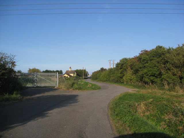
Axletree Hurn is a picturesque freshwater marsh located in the county of Lincolnshire, England. The site boasts a serene lake, a beautiful pool, and a tranquil pond, making it a haven for nature enthusiasts and birdwatchers.
The lake at Axletree Hurn spans over a considerable area, reflecting the surrounding greenery and creating a serene atmosphere. Its crystal-clear waters are home to various species of fish, providing an ideal spot for anglers seeking a peaceful fishing experience.
Adjacent to the lake is a charming pool, which is fed by natural springs. This pool is known for its calm, undisturbed waters, providing a stunning reflection of the surrounding landscape. It serves as a popular spot for wildlife, attracting a plethora of bird species and other small animals.
Furthermore, a small pond can be found within Axletree Hurn, nestled amidst the marshland. This pond is a hub of biodiversity, home to numerous amphibians and insects that thrive in the wetland habitat. It serves as a breeding ground for various species and adds to the overall ecological significance of the area.
The marshland surrounding these water bodies is a lush, verdant landscape, teeming with diverse flora and fauna. Reeds, sedges, and other wetland plants thrive in the marsh, creating a vibrant ecosystem that supports a wide range of wildlife. The area is particularly renowned for its bird population, attracting rare species such as bitterns, herons, and various waterfowl.
Axletree Hurn in Lincolnshire offers a harmonious blend of water bodies and wetland habitat, providing a unique and captivating natural experience for visitors.
If you have any feedback on the listing, please let us know in the comments section below.
Axletree Hurn Images
Images are sourced within 2km of 53.315728/0.22974214 or Grid Reference TF4882. Thanks to Geograph Open Source API. All images are credited.


Axletree Hurn is located at Grid Ref: TF4882 (Lat: 53.315728, Lng: 0.22974214)
Administrative County: Lincolnshire
District: East Lindsey
Police Authority: Lincolnshire
What 3 Words
///blatantly.looks.tonight. Near Mablethorpe, Lincolnshire
Nearby Locations
Related Wikis

Hagnaby Abbey
Hagnaby Abbey was an abbey and former priory in Hagnaby, Lincolnshire, England. It was one of nine Premonstratensian houses within the historical county...
Mablethorpe and Sutton
Mablethorpe and Sutton is a civil parish in East Lindsey, Lincolnshire, England. It is on the North Sea coast and includes Mablethorpe, Trusthorpe, Sutton...

Maltby le Marsh
Maltby le Marsh is a village and civil parish in the East Lindsey district of Lincolnshire, England. The village is situated between Alford and Mablethorpe...

St Mary's Church, Mablethorpe
St Mary's Church is an active Anglican parish church in Mablethorpe, Lincolnshire, England. Built in the early 14th century, it was renovated with additions...
Trusthorpe
Trusthorpe is a small coastal village in the East Lindsey district of Lincolnshire, England. It is situated 2 miles (3.2 km) south from Mablethorpe and...

Alford and Sutton Tramway
The Alford and Sutton Tramway was a steam 2 ft 6 in (762 mm) narrow gauge street tramway between the seaside town of Sutton-on-Sea and the nearby Great...

Strubby
Strubby is a village in the East Lindsey district of Lincolnshire, England. It is situated just north of the A157 road, 8 miles (13 km) south-east from...

Markby
Markby is a village and civil parish in the East Lindsey district of Lincolnshire, England. It is situated approximately 4 miles (6 km) north-east from...
Related Videos
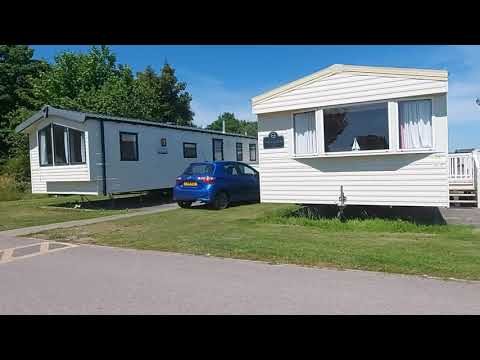
Golden Sands Holiday Haven/Caravan Park, in Mablethorpe Lincolnshire England
Golden Sand Holiday Haven is a beautiful coastal holiday park situated in Mablethorpe, England. This park offers visitors a ...

Travel day to Mablethorpe (WHAT A DISASTER IT WAS)
Hi guys So the original plan was to travel up on the Sunday and stay in a travel lodge or something like that so we didn't have ...

FPV Alien Whooping on holiday
Project zero on holiday . Had to get a few packs in.

Mablethorpe Camping and Caravanning Club Site
Easy access to the long, sandy beaches of Lincolnshire's seaside coast from this campsite. The seaside is the big draw for our ...
Nearby Amenities
Located within 500m of 53.315728,0.22974214Have you been to Axletree Hurn?
Leave your review of Axletree Hurn below (or comments, questions and feedback).