Banbury Reservoir

Lake, Pool, Pond, Freshwater Marsh in Middlesex

England

Banbury Reservoir
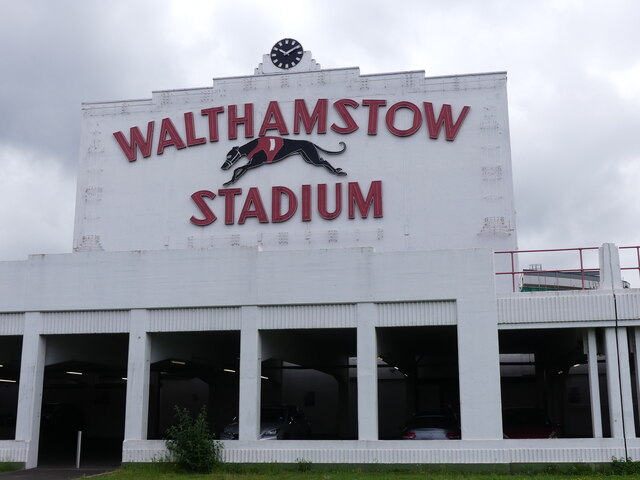
Walthamstow Stadium Dog Track (as was) The frontage to the old dog racing stadium remains but no dogs race here now, officially anyway. The clock still tells the correct time.
Walthamstow Stadium Dog Track (as was) Credit: John Kingdon

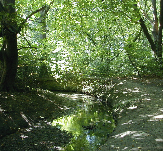
Banbury Reservoir, located in Middlesex, is a man-made freshwater lake that serves multiple purposes for the surrounding area. Built in the early 19th century, this reservoir was constructed to provide a reliable water supply for the growing population. It covers an area of approximately 50 acres and has a capacity of around 150 million gallons of water.

The reservoir is fed by a network of streams and underground springs, ensuring a constant flow of freshwater. Its main function is to supply drinking water to the nearby towns and villages, making it an essential resource for the local community. The water is treated and purified before being distributed to households and businesses.

In addition to its practical use, Banbury Reservoir also serves as a recreational area for residents and visitors alike. The calm and serene atmosphere of the reservoir attracts nature enthusiasts, walkers, and anglers. The surrounding green spaces provide ample opportunities for leisurely walks, picnics, and birdwatching.

The reservoir is home to a variety of bird species, including ducks, swans, and herons, making it a popular spot for birdwatching enthusiasts. The tranquil waters also attract a range of fish, such as carp and perch, which makes it an ideal location for fishing.

Overall, Banbury Reservoir in Middlesex is a vital water source that fulfills the needs of the local population while also offering a peaceful and picturesque setting for recreational activities.

If you have any feedback on the listing, please let us know in the comments section below.

Banbury Reservoir Images

Images are sourced within 2km of 51.604963/-0.035131263 or Grid Reference TQ3691. Thanks to Geograph Open Source API. All images are credited.

Walthamstow Stadium Dog Track (as was) The frontage to the old dog racing stadium remains but no dogs race here now, officially anyway. The clock still tells the correct time.
Walthamstow Stadium Dog Track (as was)
The frontage to the old dog racing stadium remains but no dogs race here now, officially anyway. The clock still tells the correct time.
British Cars Graveyard in Walthamstow Like an elephants' graveyard is this where old British cars go to die? I read that there are three million vehicles in the UK that are registered as off road. A staggering number I thought. Well here are three of them.
British Cars Graveyard in Walthamstow
Like an elephants' graveyard is this where old British cars go to die? I read that there are three million vehicles in the UK that are registered as off road. A staggering number I thought. Well here are three of them.
Waterside Cafe, Stonebridge Lock
Walthamstow Greyhound Stadium The stadium closed on 16 August 2008 and the site is now covered with apartments
More information > <span class="nowrap"><a title="https://en.wikipedia.org/wiki/Walthamstow_Stadium" rel="nofollow ugc noopener" href="https://en.wikipedia.org/wiki/Walthamstow_Stadium">Link</a><img style="margin-left:2px;" alt="External link" title="External link - shift click to open in new window" src="https://s1.geograph.org.uk/img/external.png" width="10" height="10"/></span>
Walthamstow Greyhound Stadium
The stadium closed on 16 August 2008 and the site is now covered with apartments More information > LinkExternal link
Walthamstow Greyhound Racing Stadium - The finish line This stadium opened in 1933 and closed in August 2008 soon after this photo was taken. For more information see - <span class="nowrap"><a title="https://en.wikipedia.org/wiki/Walthamstow_Stadium" rel="nofollow ugc noopener" href="https://en.wikipedia.org/wiki/Walthamstow_Stadium">Link</a><img style="margin-left:2px;" alt="External link" title="External link - shift click to open in new window" src="https://s1.geograph.org.uk/img/external.png" width="10" height="10"/></span>
Walthamstow Greyhound Racing Stadium - The finish line
This stadium opened in 1933 and closed in August 2008 soon after this photo was taken. For more information see - LinkExternal link
Walthamstow Greyhound Racing Stadium - Art Deco facade This stadium opened in 1933 and closed on 16 August 2008 soon after this photo was taken and the site is now covered with apartments. For more information see - <span class="nowrap"><a title="https://en.wikipedia.org/wiki/Walthamstow_Stadium" rel="nofollow ugc noopener" href="https://en.wikipedia.org/wiki/Walthamstow_Stadium">Link</a><img style="margin-left:2px;" alt="External link" title="External link - shift click to open in new window" src="https://s1.geograph.org.uk/img/external.png" width="10" height="10"/></span>
This facade still stands as a reminder to the former stadium see <span class="nowrap"><a title="https://goo.gl/maps/nEzwd8qcMpk2a6766" rel="nofollow ugc noopener" href="https://goo.gl/maps/nEzwd8qcMpk2a6766">Link</a><img style="margin-left:2px;" alt="External link" title="External link - shift click to open in new window" src="https://s1.geograph.org.uk/img/external.png" width="10" height="10"/></span>
The other side of this structure was once the Tote board see <a title="https://www.geograph.org.uk/photo/1904391" href="https://www.geograph.org.uk/photo/1904391">Link</a>
Walthamstow Greyhound Racing Stadium - Art Deco facade
This stadium opened in 1933 and closed on 16 August 2008 soon after this photo was taken and the site is now covered with apartments. For more information see - LinkExternal link This facade still stands as a reminder to the former stadium see LinkExternal link The other side of this structure was once the Tote board see Link
Walthamstow Stadium Greyhound racing since 1933
Walthamstow Stadium
Greyhound racing since 1933
Business Park South Chingford The warehouses are situated at a lower level to the 
viaducts carrying the traffic. {which was stationary and allowed me to get the camera working}
Business Park South Chingford
The warehouses are situated at a lower level to the viaducts carrying the traffic. {which was stationary and allowed me to get the camera working}
Lee Navigation, Tottenham Workboat Enfield chugging south alongside industrial premises on the east bank just to the north of Tottenham Lock and Ferry Road bridge.
Lee Navigation, Tottenham
Workboat Enfield chugging south alongside industrial premises on the east bank just to the north of Tottenham Lock and Ferry Road bridge.
Stonebridge Lock, Lee and Stort Navigation Stonebridge Lock, Tottenham, looking north, with Tottenham Marshes to the left.
Stonebridge Lock, Lee and Stort Navigation
Stonebridge Lock, Tottenham, looking north, with Tottenham Marshes to the left.
National Cycle Route 1, Lee Valley The renovated towpath alongside the Lee and Stort Navigation provides a wonderful linear traffic-free route from Essex and Hertfordshire into central London for walkers and cyclists. Here, just south of Edmonton a branch looping Banbury Reservoir (coming in from the left) re-joins the main route, with London ahead.
National Cycle Route 1, Lee Valley
The renovated towpath alongside the Lee and Stort Navigation provides a wonderful linear traffic-free route from Essex and Hertfordshire into central London for walkers and cyclists. Here, just south of Edmonton a branch looping Banbury Reservoir (coming in from the left) re-joins the main route, with London ahead.
LondonWaste EcoPark LondonWaste EcoPark (careful with the punctuation!) aka Edmonton Incinerator sits on the west side of the Lee Navigation at Edmonton, just north of where North Circular Road (A406) crosses the canal.  This plant is one of the reasons that plans for a National Athletics Arena at Picketts Lock were dropped. Couldn't have visitors breathing in these nasty fumes, could we ? Ok for the locals, though, they're used to it.
LondonWaste EcoPark
LondonWaste EcoPark (careful with the punctuation!) aka Edmonton Incinerator sits on the west side of the Lee Navigation at Edmonton, just north of where North Circular Road (A406) crosses the canal. This plant is one of the reasons that plans for a National Athletics Arena at Picketts Lock were dropped. Couldn't have visitors breathing in these nasty fumes, could we ? Ok for the locals, though, they're used to it.
Anglers Under the North Circular Anglers congregate under the bridge which carries the North Circular road (A406) over the Lee Navigation at Edmonton.  They say they're there because the fish congregate there as the water is slightly warmer.  Well, maybe, but it's also a relatively cosy spot on an otherwise windswept canal-side.
Anglers Under the North Circular
Anglers congregate under the bridge which carries the North Circular road (A406) over the Lee Navigation at Edmonton. They say they're there because the fish congregate there as the water is slightly warmer. Well, maybe, but it's also a relatively cosy spot on an otherwise windswept canal-side.
Approaching Stonebridge Lock, Tottenham The Lee and Stort Navigation, looking north, with Tottenham Marshes on the left and Lockwood reservoir on the right.
Approaching Stonebridge Lock, Tottenham
The Lee and Stort Navigation, looking north, with Tottenham Marshes on the left and Lockwood reservoir on the right.
Poplars, raptor, marsh and sub-station.. Tottenham Marshes seen from across the Lee and Stort Navigation.
Poplars, raptor, marsh and sub-station..
Tottenham Marshes seen from across the Lee and Stort Navigation.
Unnecessary Advertisement ? This is Old Church Road, E4, looking north up the hill with the trees of Chingford Mount cemetery visible centre right.  You wouldn't have thought there was any need to advertise the item promoted in the right foreground.
Unnecessary Advertisement ?
This is Old Church Road, E4, looking north up the hill with the trees of Chingford Mount cemetery visible centre right. You wouldn't have thought there was any need to advertise the item promoted in the right foreground.
Pylons in the Lea Valley This is not the most attractive part of the Lea (or Lee) Valley.  The A406 North Circular road crosses the river, canal and various drainage channels.  There are electricity pylons, gas holders, industrial estates and retail sheds.
This picture was taken near a pumping station, close to Banbury reservoir and Costco.
Pylons in the Lea Valley
This is not the most attractive part of the Lea (or Lee) Valley. The A406 North Circular road crosses the river, canal and various drainage channels. There are electricity pylons, gas holders, industrial estates and retail sheds. This picture was taken near a pumping station, close to Banbury reservoir and Costco.
End of terrace near Lloyd Park, Walthamstow Taken on the corner of Winns Terrace (left) and Winns Avenue (right).
End of terrace near Lloyd Park, Walthamstow
Taken on the corner of Winns Terrace (left) and Winns Avenue (right).
Show me another place!

Banbury Reservoir is located at Grid Ref: TQ3691 (Lat: 51.604963, Lng: -0.035131263)

Unitary Authority: Waltham Forest

Police Authority: Metropolitan

What 3 Words

///assist.shower.coats. Near Walthamstow, London

Nearby Locations

Banbury Reservoir

Related Wikis

Banbury Reservoir

Banbury Reservoir is located at Walthamstow in the London Borough of Waltham Forest. It is one of the storage reservoirs of the Lee Valley Reservoir Chain...

River Ching

The River Ching is a tributary of the River Lea, flowing from Epping Forest, in southeast England. == Course == The Ching originates as a small stream...

Building BloQs

Building BloQs is an open workshop in Enfield, London. A social enterprise, their emphasis is on creating and maintaining space and resources for people...

Salmons Brook

Salmons Brook is a minor tributary of the River Lea, located in the London Borough of Enfield. == Etymology == Salmons Brook is marked thus on Rocque...

Nearby Amenities

Located within 500m of 51.604963,-0.035131263
Waterway: weir
Lat/Long: 51.6044256/-0.0422804
Traffic Calming: island
Lat/Long: 51.6078108/-0.0305408
Fuel
Pure Fuels
Fuel Biodiesel: yes
Self Service: no
Lat/Long: 51.6084884/-0.0365496
Mini Roundabout
Direction: clockwise
Lat/Long: 51.6014254/-0.0334466
Fuel
BP
Brand: BP
Brand Wikidata: Q152057
Operator: Rontec
Operator Website: http://www.rontec-servicestations.co.uk/ss_results-id.cfm?id=7208
Operator Wikidata: Q107439152
Lat/Long: 51.607772/-0.0302093
Power: tower
Lat/Long: 51.6050624/-0.0413805
Power: tower
Lat/Long: 51.6065182/-0.0386559
Power: tower
Lat/Long: 51.6080403/-0.0342281
Power: tower
Lat/Long: 51.6059158/-0.0415226
Power: tower
Lat/Long: 51.6071792/-0.0384499
Power: tower
Lat/Long: 51.6084265/-0.0353342
Power: tower
Lat/Long: 51.6048017/-0.0414625
Power: tower
Lat/Long: 51.6022748/-0.0385271
Power: tower
Lat/Long: 51.6018803/-0.0337206
Power: tower
Lat/Long: 51.6031331/-0.0289742
Access: no
Barrier: block
Bicycle: yes
Foot: yes
Lat/Long: 51.6015374/-0.0334911
Bus Stop
William Morris School
Naptan AtcoCode: 490014698N
Naptan Bearing: N
Naptan CommonName: William Morris School
Naptan Street: FOLLY LANE
Naptan Verified: no
Public Transport: platform
Lat/Long: 51.6007738/-0.0334306
Bus Stop
Hail & Ride Cormorant Close
Naptan AtcoCode: 490016662W
Naptan Bearing: W
Naptan CommonName: Cormorant Close
Naptan Verified: no
Physically Present: no
Public Transport: platform
Lat/Long: 51.6015181/-0.0381602
Barrier: block
Lat/Long: 51.6037816/-0.0290673
Fixme: continue
Lat/Long: 51.6020014/-0.0333659
Barrier: bollard
Bollard: fixed
Source: survey
Lat/Long: 51.6018771/-0.0391749
Barrier: bollard
Source: survey
Lat/Long: 51.6019949/-0.038761
Traffic Calming: choker
Lat/Long: 51.6020414/-0.036161
Barrier: cycle_barrier
Bicycle: yes
Lat/Long: 51.6057335/-0.0422347
Addr Country: GB
Addr Housenumber: 47
Addr Street: Durban Road
Addr Suburb: Walthamstow
Source: survey
Lat/Long: 51.6019735/-0.0297619
Addr Country: GB
Addr Housenumber: 65
Addr Street: Durban Road
Addr Suburb: Walthamstow
Source: survey
Lat/Long: 51.6022775/-0.0298974
Addr Country: GB
Addr Housenumber: 18
Addr Street: Ascham End
Addr Suburb: Walthamstow
Source: survey
Lat/Long: 51.6010689/-0.0316475
Addr Country: GB
Addr Housenumber: 19
Addr Street: Ascham End
Addr Suburb: Walthamstow
Source: survey
Lat/Long: 51.6011471/-0.0314906
Addr Country: GB
Addr Housenumber: 12
Addr Street: Stow Crescent
Addr Suburb: Walthamstow
Source: survey
Lat/Long: 51.6016032/-0.0303412
Addr Country: GB
Addr Housenumber: 13
Addr Street: Stow Crescent
Addr Suburb: Walthamstow
Source: survey
Lat/Long: 51.6018298/-0.0303185
Addr Country: GB
Addr Housenumber: 20
Addr Street: Stow Crescent
Addr Suburb: Walthamstow
Source: survey
Lat/Long: 51.602073/-0.0304217
Addr Country: GB
Addr Housenumber: 21
Addr Street: Stow Crescent
Addr Suburb: Walthamstow
Source: survey
Lat/Long: 51.6019697/-0.0308556
Addr Country: GB
Addr Housenumber: 26
Addr Street: Stow Crescent
Addr Suburb: Walthamstow
Source: survey
Lat/Long: 51.6017948/-0.0307758
Addr Country: GB
Addr Housenumber: 27
Addr Street: Stow Crescent
Addr Suburb: Walthamstow
Source: survey
Lat/Long: 51.6015882/-0.0306236
Addr Country: GB
Addr Housenumber: 42
Addr Street: Stow Crescent
Addr Suburb: Walthamstow
Source: survey
Lat/Long: 51.6015208/-0.0314873
Addr Country: GB
Addr Housenumber: 43
Addr Street: Stow Crescent
Addr Suburb: Walthamstow
Source: survey
Lat/Long: 51.601709/-0.0314309
Addr Country: GB
Addr Housenumber: 48
Addr Street: Stow Crescent
Addr Suburb: Walthamstow
Source: survey
Lat/Long: 51.6018881/-0.0314524
Addr Country: GB
Addr Housenumber: 57
Addr Street: Kimberley Road
Source: survey
Lat/Long: 51.6015358/-0.0318688
Addr Country: GB
Addr Housenumber: 58
Addr Street: Kimberley Road
Source: survey
Lat/Long: 51.6014922/-0.031859
Addr Country: GB
Addr Housenumber: 64
Addr Street: Kimberley Road
Source: survey
Lat/Long: 51.6013242/-0.0317662
Addr Country: GB
Addr Housenumber: 49
Addr Street: Kimberley Road
Source: survey
Lat/Long: 51.6018506/-0.0319553
Fixme: continue
Lat/Long: 51.6059865/-0.0286304
Fixme: continue
Lat/Long: 51.6034402/-0.0293278
Fixme: continue
Lat/Long: 51.6060131/-0.0297381
Addr City: London
Addr Country: GB
Addr Housenumber: 37-47
Addr Street: Amber Avenue
Addr Suburb: Walthamstow
Entrance: main
Source: survey
Lat/Long: 51.6006668/-0.0341195
Addr City: London
Addr Country: GB
Addr Housenumber: 38-48
Addr Street: Amber Avenue
Addr Suburb: Walthamstow
Entrance: main
Source: survey
Lat/Long: 51.6006807/-0.0337508
Addr City: London
Addr Country: GB
Addr Housenumber: 1
Addr Street: Osprey Close
Addr Suburb: Walthamstow
Source: survey
Lat/Long: 51.6016216/-0.0331718
Addr City: London
Addr Country: GB
Addr Housenumber: 11
Addr Street: Osprey Close
Addr Suburb: Walthamstow
Source: survey
Lat/Long: 51.6016974/-0.0328473
Addr City: London
Addr Country: GB
Addr Housenumber: 12
Addr Street: Osprey Close
Addr Suburb: Walthamstow
Source: survey
Lat/Long: 51.6016857/-0.032689
Addr City: London
Addr Country: GB
Addr Housenumber: 18
Addr Street: Osprey Close
Addr Suburb: Walthamstow
Source: survey
Lat/Long: 51.6017257/-0.0323082
Addr City: London
Addr Country: GB
Addr Housenumber: 19
Addr Street: Osprey Close
Addr Suburb: Walthamstow
Source: survey
Lat/Long: 51.6014924/-0.0324577
Addr City: London
Addr Country: GB
Addr Housenumber: 23
Addr Street: Osprey Close
Addr Suburb: Walthamstow
Source: survey
Lat/Long: 51.6013775/-0.0324128
Addr City: London
Addr Country: GB
Addr Housenumber: 24
Addr Street: Osprey Close
Addr Suburb: Walthamstow
Source: survey
Lat/Long: 51.6012055/-0.0321258
Addr City: London
Addr Country: GB
Addr Housenumber: 31
Addr Street: Osprey Close
Addr Suburb: Walthamstow
Source: survey
Lat/Long: 51.601158/-0.0324946
Addr City: London
Addr Country: GB
Addr Housenumber: 13
Addr Street: Cooper Avenue
Addr Suburb: Walthamstow
Source: survey
Lat/Long: 51.600781/-0.0375508
Addr City: London
Addr Country: GB
Addr Housenumber: 17
Addr Street: Cooper Avenue
Addr Suburb: Walthamstow
Source: survey
Lat/Long: 51.6008553/-0.0376956
Addr City: London
Addr Country: GB
Addr Housenumber: 27
Addr Street: Cooper Avenue
Addr Suburb: Walthamstow
Source: survey
Lat/Long: 51.6009875/-0.0380393
Addr City: London
Addr Country: GB
Addr Housenumber: 29
Addr Street: Cooper Avenue
Addr Suburb: Walthamstow
Source: survey
Lat/Long: 51.601025/-0.038207
Addr City: London
Addr Country: GB
Addr Housenumber: 35
Addr Street: Cooper Avenue
Addr Suburb: Walthamstow
Source: survey
Lat/Long: 51.6010265/-0.0384456
Addr City: London
Addr Country: GB
Addr Housenumber: 1
Addr Street: Sandpiper Close
Addr Suburb: Walthamstow
Source: survey
Lat/Long: 51.6016272/-0.0382963
Addr City: London
Addr Country: GB
Addr Housenumber: 10
Addr Street: Banbury Road
Addr Suburb: Walthamstow
Source: survey
Lat/Long: 51.6016984/-0.0376645
Addr City: London
Addr Country: GB
Addr Housenumber: 13
Addr Street: Sandpiper Close
Addr Suburb: Walthamstow
Source: survey
Lat/Long: 51.6013542/-0.0385236
Addr City: London
Addr Country: GB
Addr Housenumber: 14
Addr Street: Banbury Road
Addr Suburb: Walthamstow
Source: survey
Lat/Long: 51.6018102/-0.0376076
Addr City: London
Addr Country: GB
Addr Housenumber: 16
Addr Street: Banbury Road
Addr Suburb: Walthamstow
Source: survey
Lat/Long: 51.6018661/-0.0375356
Addr City: London
Addr Country: GB
Addr Housenumber: 2
Addr Street: Banbury Road
Addr Suburb: Walthamstow
Source: survey
Lat/Long: 51.6014937/-0.037995
Addr City: London
Addr Country: GB
Addr Housenumber: 20
Addr Street: Banbury Road
Addr Suburb: Walthamstow
Source: survey
Lat/Long: 51.6019814/-0.0374693
Addr City: London
Addr Country: GB
Addr Housenumber: 20
Addr Street: Sandpiper Close
Addr Suburb: Walthamstow
Source: survey
Lat/Long: 51.601373/-0.0392454
Addr City: London
Addr Country: GB
Addr Housenumber: 6
Addr Street: Sandpiper Close
Addr Suburb: Walthamstow
Source: survey
Lat/Long: 51.6017884/-0.0386448
Addr City: London
Addr Country: GB
Addr Housenumber: 7
Addr Street: Sandpiper Close
Addr Suburb: Walthamstow
Source: survey
Lat/Long: 51.6015884/-0.0388759
Addr City: London
Addr Country: GB
Addr Housenumber: 8
Addr Street: Banbury Road
Addr Suburb: Walthamstow
Source: survey
Lat/Long: 51.6016484/-0.0378729
Addr City: London
Addr Country: GB
Addr Housenumber: 1
Addr Street: Cormorant Close
Addr Suburb: Walthamstow
Source: survey
Lat/Long: 51.6015242/-0.0376649
Addr City: London
Addr Country: GB
Addr Housenumber: 15
Addr Street: Swift Close
Addr Suburb: Walthamstow
Source: survey
Lat/Long: 51.6016738/-0.036394
Addr City: London
Addr Country: GB
Addr Housenumber: 2
Addr Street: Swift Close
Addr Suburb: Walthamstow
Source: survey
Lat/Long: 51.601575/-0.0350679
Addr City: London
Addr Country: GB
Addr Housenumber: 20
Addr Street: Swift Close
Addr Suburb: Walthamstow
Source: survey
Lat/Long: 51.6013903/-0.0359943
Addr City: London
Addr Country: GB
Addr Housenumber: 22
Addr Street: Banbury Road
Addr Suburb: Walthamstow
Source: survey
Lat/Long: 51.6020034/-0.0372387
Addr City: London
Addr Country: GB
Addr Housenumber: 25
Addr Street: Swift Close
Addr Suburb: Walthamstow
Source: survey
Lat/Long: 51.6013514/-0.0354146
Addr City: London
Addr Country: GB
Addr Housenumber: 26
Addr Street: Banbury Road
Addr Suburb: Walthamstow
Source: survey
Lat/Long: 51.6019844/-0.0370247
Addr City: London
Addr Country: GB
Addr Housenumber: 26
Addr Street: Swift Close
Addr Suburb: Walthamstow
Source: survey
Lat/Long: 51.601342/-0.0353294
Addr City: London
Addr Country: GB
Addr Housenumber: 28
Addr Street: Banbury Road
Addr Suburb: Walthamstow
Source: survey
Lat/Long: 51.6019675/-0.0368353
Addr City: London
Addr Country: GB
Addr Housenumber: 28
Addr Street: Swift Close
Addr Suburb: Walthamstow
Source: survey
Lat/Long: 51.6013444/-0.0350566
Addr City: London
Addr Country: GB
Addr Housenumber: 29
Addr Street: Swift Close
Addr Suburb: Walthamstow
Source: survey
Lat/Long: 51.6013514/-0.0349637
Addr City: London
Addr Country: GB
Addr Housenumber: 3
Addr Street: Greenshank Close
Addr Suburb: Walthamstow
Source: survey
Lat/Long: 51.6017343/-0.0369574
Addr City: London
Addr Country: GB
Addr Housenumber: 31
Addr Street: Swift Close
Addr Suburb: Walthamstow
Source: survey
Lat/Long: 51.6013733/-0.0347347
Addr City: London
Addr Country: GB
Addr Housenumber: 36
Addr Street: Banbury Road
Addr Suburb: Walthamstow
Source: survey
Lat/Long: 51.6019297/-0.0363957
Addr City: London
Addr Country: GB
Addr Housenumber: 42
Addr Street: Banbury Road
Addr Suburb: Walthamstow
Source: survey
Lat/Long: 51.6018987/-0.0358539
Addr City: London
Addr Country: GB
Addr Housenumber: 46
Addr Street: Banbury Road
Addr Suburb: Walthamstow
Source: survey
Lat/Long: 51.6017987/-0.0358823
Addr City: London
Addr Country: GB
Addr Housenumber: 48
Addr Street: Banbury Road
Addr Suburb: Walthamstow
Source: survey
Lat/Long: 51.6018746/-0.0356086
Addr City: London
Addr Country: GB
Addr Housenumber: 5
Addr Street: Cormorant Close
Addr Suburb: Walthamstow
Source: survey
Lat/Long: 51.6015068/-0.0371918
Addr City: London
Addr Country: GB
Addr Housenumber: 6
Addr Street: Greenshank Close
Addr Suburb: Walthamstow
Source: survey
Lat/Long: 51.6017666/-0.0373334
Addr City: London
Addr Country: GB
Addr Housenumber: 66
Addr Street: Banbury Road
Addr Suburb: Walthamstow
Source: survey
Lat/Long: 51.6018028/-0.0348527
Addr City: London
Addr Country: GB
Addr Housenumber: 1
Addr Street: Swan Close
Addr Suburb: Walthamstow
Source: survey
Lat/Long: 51.60142/-0.0344575
Addr City: London
Addr Country: GB
Addr Housenumber: 12
Addr Street: Swan Close
Addr Suburb: Walthamstow
Source: survey
Lat/Long: 51.601027/-0.0339213
Addr City: London
Addr Country: GB
Addr Housenumber: 6
Addr Street: Swan Close
Addr Suburb: Walthamstow
Source: survey
Lat/Long: 51.6011446/-0.0344707
Addr City: London
Addr Country: GB
Addr Housenumber: 7
Addr Street: Swan Close
Addr Suburb: Walthamstow
Source: survey
Lat/Long: 51.6010164/-0.0343495
Addr City: London
Addr Country: GB
Addr Housenumber: 70
Addr Street: Banbury Road
Addr Suburb: Walthamstow
Source: survey
Lat/Long: 51.601467/-0.0344613
Addr City: London
Addr Country: GB
Addr Housenumber: 10
Addr Street: Cogan Avenue
Addr Suburb: Walthamstow
Source: survey
Lat/Long: 51.6010989/-0.0365088
Addr City: London
Addr Country: GB
Addr Housenumber: 10
Addr Street: Cooper Avenue
Addr Suburb: Walthamstow
Source: survey
Lat/Long: 51.6006258/-0.0358906
Addr City: London
Addr Country: GB
Addr Housenumber: 16
Addr Street: Cooper Avenue
Addr Suburb: Walthamstow
Source: survey
Lat/Long: 51.6006907/-0.0360958
Addr City: London
Addr Country: GB
Addr Housenumber: 18
Addr Street: Cooper Avenue
Addr Suburb: Walthamstow
Source: survey
Lat/Long: 51.6007041/-0.0362969
Addr City: London
Addr Country: GB
Addr Housenumber: 19
Addr Street: Valognes Avenue
Addr Suburb: Walthamstow
Source: survey
Lat/Long: 51.6005704/-0.0351171
Addr City: London
Addr Country: GB
Addr Housenumber: 2
Addr Street: Cogan Avenue
Addr Suburb: Walthamstow
Source: survey
Lat/Long: 51.6011306/-0.0369024
Addr City: London
Addr Country: GB
Addr Housenumber: 20
Addr Street: Cogan Avenue
Addr Suburb: Walthamstow
Source: survey
Lat/Long: 51.6010956/-0.0360877
Addr City: London
Addr Country: GB
Addr Housenumber: 21
Addr Street: Valognes Avenue
Addr Suburb: Walthamstow
Source: survey
Lat/Long: 51.6006734/-0.035131
Addr City: London
Addr Country: GB
Addr Housenumber: 22
Addr Street: Cogan Avenue
Addr Suburb: Walthamstow
Source: survey
Lat/Long: 51.6011229/-0.0359456
Addr City: London
Addr Country: GB
Addr Housenumber: 27
Addr Street: Valognes Avenue
Addr Suburb: Walthamstow
Source: survey
Lat/Long: 51.6008119/-0.0351496
Addr City: London
Addr Country: GB
Addr Housenumber: 28
Addr Street: Cogan Avenue
Addr Suburb: Walthamstow
Source: survey
Lat/Long: 51.601121/-0.0356995
Addr City: London
Addr Country: GB
Addr Housenumber: 28
Addr Street: Cooper Avenue
Addr Suburb: Walthamstow
Source: survey
Lat/Long: 51.6006457/-0.0366657
Addr City: London
Addr Country: GB
Addr Housenumber: 29
Addr Street: Valognes Avenue
Addr Suburb: Walthamstow
Source: survey
Lat/Long: 51.6009327/-0.0351898
Addr City: London
Addr Country: GB
Addr Housenumber: 30
Addr Street: Cooper Avenue
Addr Suburb: Walthamstow
Source: survey
Lat/Long: 51.6007465/-0.0369085
Addr City: London
Addr Country: GB
Addr Housenumber: 30
Addr Street: Valognes Avenue
Addr Suburb: Walthamstow
Source: survey
Lat/Long: 51.6005388/-0.0347216
Addr City: London
Addr Country: GB
Addr Housenumber: 36
Addr Street: Cooper Avenue
Addr Suburb: Walthamstow
Source: survey
Lat/Long: 51.600854/-0.0371163
Addr City: London
Addr Country: GB
Addr Housenumber: 36
Addr Street: Valognes Avenue
Addr Suburb: Walthamstow
Source: survey
Lat/Long: 51.600682/-0.0347415
Addr City: London
Addr Country: GB
Addr Housenumber: 38
Addr Street: Cooper Avenue
Addr Suburb: Walthamstow
Source: survey
Lat/Long: 51.6009939/-0.0373457
Addr City: London
Addr Country: GB
Addr Housenumber: 38
Addr Street: Valognes Avenue
Addr Suburb: Walthamstow
Source: survey
Lat/Long: 51.6007847/-0.0347734
Addr City: London
Addr Country: GB
Addr Housenumber: 39
Addr Street: Valognes Avenue
Addr Suburb: Walthamstow
Source: survey
Lat/Long: 51.6011051/-0.0354983
Addr City: London
Addr Country: GB
Addr Housenumber: 44
Addr Street: Cooper Avenue
Addr Suburb: Walthamstow
Source: survey
Lat/Long: 51.6011331/-0.0372652
Addr City: London
Addr Country: GB
Addr Housenumber: 48
Addr Street: Valognes Avenue
Addr Suburb: Walthamstow
Source: survey
Lat/Long: 51.6010123/-0.034805
Addr City: London
Addr Country: GB
Addr Housenumber: 50
Addr Street: Valognes Avenue
Addr Suburb: Walthamstow
Source: survey
Lat/Long: 51.6011264/-0.0349109
Addr City: London
Addr Country: GB
Addr Housenumber: 52
Addr Street: Valognes Avenue
Addr Suburb: Walthamstow
Source: survey
Lat/Long: 51.601193/-0.0349887
Addr City: London
Addr Country: GB
Addr Housenumber: 8
Addr Street: Cogan Avenue
Addr Suburb: Walthamstow
Source: survey
Lat/Long: 51.6011285/-0.0366496
Addr City: London
Addr Country: GB
Addr Housenumber: 8
Addr Street: Cooper Avenue
Addr Suburb: Walthamstow
Source: survey
Lat/Long: 51.6005116/-0.035794
Bench
Lat/Long: 51.6011052/-0.0329774
Bench
Lat/Long: 51.6012976/-0.0330057
William Morris School
Bus: yes
Public Transport: stop_position
Lat/Long: 51.6007769/-0.0333519
Bus Stop
Hail & Ride Cooper Avenue
Physically Present: no
Public Transport: platform
Lat/Long: 51.6011051/-0.0384673
Bus Stop
Hail & Ride Sandpiper Close
Physically Present: no
Public Transport: platform
Lat/Long: 51.6018064/-0.0377581
Bus Stop
Hail & Ride Banbury Road
Physically Present: no
Public Transport: platform
Lat/Long: 51.6020151/-0.0363631
Bus Stop
Hail & Ride Swift Close / Grebe Close
Physically Present: no
Public Transport: platform
Lat/Long: 51.6016847/-0.0346835
Bus Stop
Hail & Ride Swan Close
Physically Present: no
Public Transport: platform
Lat/Long: 51.6014326/-0.0342729
Bus Stop
Hail & Ride Osprey Close
Physically Present: no
Public Transport: platform
Lat/Long: 51.6013572/-0.0335265
Traffic Calming: island
Lat/Long: 51.6074775/-0.0308036
Crossing
Crossing: unmarked
Crossing Island: yes
Lat/Long: 51.6077334/-0.0309629
Generator Method: photovoltaic
Generator Output Electricity: yes
Generator Source: solar
Generator Type: solar_photovoltaic_panel
Location: roof
Power: generator
Lat/Long: 51.6015929/-0.0396967
Generator Method: photovoltaic
Generator Output Electricity: yes
Generator Source: solar
Generator Type: solar_photovoltaic_panel
Location: roof
Power: generator
Lat/Long: 51.6016945/-0.0394097
Generator Method: photovoltaic
Generator Output Electricity: yes
Generator Source: solar
Generator Type: solar_photovoltaic_panel
Location: roof
Power: generator
Lat/Long: 51.6017894/-0.0391549
Generator Method: photovoltaic
Generator Output Electricity: yes
Generator Source: solar
Generator Type: solar_photovoltaic_panel
Location: roof
Power: generator
Lat/Long: 51.6010964/-0.0357726
Generator Method: photovoltaic
Generator Output Electricity: yes
Generator Source: solar
Generator Type: solar_photovoltaic_panel
Location: roof
Power: generator
Lat/Long: 51.6019544/-0.0368267
Generator Method: photovoltaic
Generator Output Electricity: yes
Generator Source: solar
Generator Type: solar_photovoltaic_panel
Location: roof
Power: generator
Lat/Long: 51.6019361/-0.036588
Generator Method: photovoltaic
Generator Output Electricity: yes
Generator Source: solar
Generator Type: solar_photovoltaic_panel
Location: roof
Power: generator
Lat/Long: 51.6019111/-0.0364056
Generator Method: photovoltaic
Generator Output Electricity: yes
Generator Source: solar
Generator Type: solar_photovoltaic_panel
Location: roof
Power: generator
Lat/Long: 51.6018977/-0.0362742
Generator Method: photovoltaic
Generator Output Electricity: yes
Generator Source: solar
Generator Type: solar_photovoltaic_panel
Location: roof
Power: generator
Lat/Long: 51.6018911/-0.0361776
Generator Method: photovoltaic
Generator Output Electricity: yes
Generator Source: solar
Generator Type: solar_photovoltaic_panel
Location: roof
Power: generator
Lat/Long: 51.6018511/-0.0356063
Generator Method: photovoltaic
Generator Output Electricity: yes
Generator Source: solar
Generator Type: solar_photovoltaic_panel
Location: roof
Power: generator
Lat/Long: 51.6018461/-0.0355285
Generator Method: photovoltaic
Generator Output Electricity: yes
Generator Source: solar
Generator Type: solar_photovoltaic_panel
Location: roof
Power: generator
Lat/Long: 51.6018378/-0.0354427
Generator Method: photovoltaic
Generator Output Electricity: yes
Generator Source: solar
Generator Type: solar_photovoltaic_panel
Location: roof
Power: generator
Lat/Long: 51.6018161/-0.0351959
Generator Method: photovoltaic
Generator Output Electricity: yes
Generator Source: solar
Generator Type: solar_photovoltaic_panel
Location: roof
Power: generator
Lat/Long: 51.6018028/-0.0350377
Generator Method: photovoltaic
Generator Output Electricity: yes
Generator Source: solar
Generator Type: solar_photovoltaic_panel
Location: roof
Power: generator
Lat/Long: 51.6017961/-0.0349492
Generator Method: photovoltaic
Generator Output Electricity: yes
Generator Source: solar
Generator Type: solar_photovoltaic_panel
Location: roof
Power: generator
Lat/Long: 51.6016545/-0.0363788
Generator Method: photovoltaic
Generator Output Electricity: yes
Generator Source: solar
Generator Type: solar_photovoltaic_panel
Location: roof
Power: generator
Lat/Long: 51.6016478/-0.0363117
Generator Method: photovoltaic
Generator Output Electricity: yes
Generator Source: solar
Generator Type: solar_photovoltaic_panel
Location: roof
Power: generator
Lat/Long: 51.6016445/-0.036234
Generator Method: photovoltaic
Generator Output Electricity: yes
Generator Source: solar
Generator Type: solar_photovoltaic_panel
Location: roof
Power: generator
Lat/Long: 51.6016378/-0.0361401
Generator Method: photovoltaic
Generator Output Electricity: yes
Generator Source: solar
Generator Type: solar_photovoltaic_panel
Location: roof
Power: generator
Lat/Long: 51.6016129/-0.0360006
Generator Method: photovoltaic
Generator Output Electricity: yes
Generator Source: solar
Generator Type: solar_photovoltaic_panel
Location: roof
Power: generator
Lat/Long: 51.6016079/-0.0359094
Generator Method: photovoltaic
Generator Output Electricity: yes
Generator Source: solar
Generator Type: solar_photovoltaic_panel
Location: roof
Power: generator
Lat/Long: 51.6016179/-0.0357565
Generator Method: photovoltaic
Generator Output Electricity: yes
Generator Source: solar
Generator Type: solar_photovoltaic_panel
Location: roof
Power: generator
Lat/Long: 51.6016045/-0.0355929
Generator Method: photovoltaic
Generator Output Electricity: yes
Generator Source: solar
Generator Type: solar_photovoltaic_panel
Location: roof
Power: generator
Lat/Long: 51.6015962/-0.0355071
Generator Method: photovoltaic
Generator Output Electricity: yes
Generator Source: solar
Generator Type: solar_photovoltaic_panel
Location: roof
Power: generator
Lat/Long: 51.6015879/-0.0354266
Generator Method: photovoltaic
Generator Output Electricity: yes
Generator Source: solar
Generator Type: solar_photovoltaic_panel
Location: roof
Power: generator
Lat/Long: 51.6015829/-0.0353327
Generator Method: photovoltaic
Generator Output Electricity: yes
Generator Source: solar
Generator Type: solar_photovoltaic_panel
Location: roof
Power: generator
Lat/Long: 51.601368/-0.0359765
Generator Method: photovoltaic
Generator Output Electricity: yes
Generator Source: solar
Generator Type: solar_photovoltaic_panel
Location: roof
Power: generator
Lat/Long: 51.6013596/-0.0358799
Generator Method: photovoltaic
Generator Output Electricity: yes
Generator Source: solar
Generator Type: solar_photovoltaic_panel
Location: roof
Power: generator
Lat/Long: 51.6013513/-0.0356519
Generator Method: photovoltaic
Generator Output Electricity: yes
Generator Source: solar
Generator Type: solar_photovoltaic_panel
Location: roof
Power: generator
Lat/Long: 51.601343/-0.0355634
Generator Method: photovoltaic
Generator Output Electricity: yes
Generator Source: solar
Generator Type: solar_photovoltaic_panel
Location: roof
Power: generator
Lat/Long: 51.601338/-0.0354615
Generator Method: photovoltaic
Generator Output Electricity: yes
Generator Source: solar
Generator Type: solar_photovoltaic_panel
Location: roof
Power: generator
Lat/Long: 51.601328/-0.0353193
Generator Method: photovoltaic
Generator Output Electricity: yes
Generator Source: solar
Generator Type: solar_photovoltaic_panel
Location: roof
Power: generator
Lat/Long: 51.6013263/-0.0352013
Generator Method: photovoltaic
Generator Output Electricity: yes
Generator Source: solar
Generator Type: solar_photovoltaic_panel
Location: roof
Power: generator
Lat/Long: 51.6013263/-0.0351074
Generator Method: photovoltaic
Generator Output Electricity: yes
Generator Source: solar
Generator Type: solar_photovoltaic_panel
Location: roof
Power: generator
Lat/Long: 51.6013363/-0.0349492
Generator Method: photovoltaic
Generator Output Electricity: yes
Generator Source: solar
Generator Type: solar_photovoltaic_panel
Location: roof
Power: generator
Lat/Long: 51.6013496/-0.0348526
Generator Method: photovoltaic
Generator Output Electricity: yes
Generator Source: solar
Generator Type: solar_photovoltaic_panel
Location: roof
Power: generator
Lat/Long: 51.6013563/-0.034748
Generator Method: photovoltaic
Generator Output Electricity: yes
Generator Source: solar
Generator Type: solar_photovoltaic_panel
Location: roof
Power: generator
Lat/Long: 51.6009515/-0.0352845
Generator Method: photovoltaic
Generator Output Electricity: yes
Generator Source: solar
Generator Type: solar_photovoltaic_panel
Location: roof
Power: generator
Lat/Long: 51.6009964/-0.0343564
Generator Method: photovoltaic
Generator Output Electricity: yes
Generator Source: solar
Generator Type: solar_photovoltaic_panel
Location: roof
Power: generator
Lat/Long: 51.6010031/-0.034284
Generator Method: photovoltaic
Generator Output Electricity: yes
Generator Source: solar
Generator Type: solar_photovoltaic_panel
Location: roof
Power: generator
Lat/Long: 51.6010064/-0.0342035
Generator Method: photovoltaic
Generator Output Electricity: yes
Generator Source: solar
Generator Type: solar_photovoltaic_panel
Location: roof
Power: generator
Lat/Long: 51.6010098/-0.034107
Generator Method: photovoltaic
Generator Output Electricity: yes
Generator Source: solar
Generator Type: solar_photovoltaic_panel
Location: roof
Power: generator
Lat/Long: 51.6010081/-0.0340131
Generator Method: photovoltaic
Generator Output Electricity: yes
Generator Source: solar
Generator Type: solar_photovoltaic_panel
Location: roof
Power: generator
Lat/Long: 51.6014646/-0.0394499
Generator Method: photovoltaic
Generator Output Electricity: yes
Generator Source: solar
Generator Type: solar_photovoltaic_panel
Location: roof
Power: generator
Lat/Long: 51.6014979/-0.0393614
Generator Method: photovoltaic
Generator Output Electricity: yes
Generator Source: solar
Generator Type: solar_photovoltaic_panel
Location: roof
Power: generator
Lat/Long: 51.6006299/-0.0359818
Generator Method: photovoltaic
Generator Output Electricity: yes
Generator Source: solar
Generator Type: solar_photovoltaic_panel
Location: roof
Power: generator
Lat/Long: 51.6006666/-0.0364271
Generator Method: photovoltaic
Generator Output Electricity: yes
Generator Source: solar
Generator Type: solar_photovoltaic_panel
Location: roof
Power: generator
Lat/Long: 51.6006582/-0.0364995
Answer: RL
Marker: plate
Orienteering: marker
Ref: 29
Sport: orienteering
Lat/Long: 51.6057583/-0.0422232
Bicycle Parking
Bicycle Parking: stands
Capacity: 4
Covered: no
Lat/Long: 51.6010712/-0.0332071
Tourism: viewpoint
Lat/Long: 51.60242/-0.0291842
Bicycle: yes
Foot: yes
Information: guidepost
Tourism: information
Lat/Long: 51.6057052/-0.0422589
Give Way
Direction: forward
Lat/Long: 51.6082771/-0.0304394
Ref GB Tflcid: RWG146414
Traffic Calming: hump
Lat/Long: 51.6007584/-0.0349697
Ref GB Tflcid: RWG146412
Traffic Calming: hump
Lat/Long: 51.6008459/-0.0373983
Ref GB Tflcid: RWG146416
Traffic Calming: hump
Lat/Long: 51.6012232/-0.036408
Kerb: lowered
Lat/Long: 51.60195/-0.0387388
Kerb: lowered
Lat/Long: 51.6019293/-0.0387006
Barrier: kerb
Lat/Long: 51.6079593/-0.0305415
Bicycle: yes
Information: guidepost
Tourism: information
Lat/Long: 51.6074891/-0.0306002
Waste Basket
Waste: dog_excrement
Lat/Long: 51.6020142/-0.0391235
The data included in this document is from www.openstreetmap.org. The data is made available under ODbL.

Have you been to Banbury Reservoir?

Leave your review of Banbury Reservoir below (or comments, questions and feedback).