Drayton Lagoon

Lake, Pool, Pond, Freshwater Marsh in Cambridgeshire South Cambridgeshire

England

Drayton Lagoon

Holywell Church, Cambs Aptly named, there is indeed a holy well within the church grounds, which flows into the nearby Great Ouse.
Holywell Church, Cambs Credit: Alan Simkins

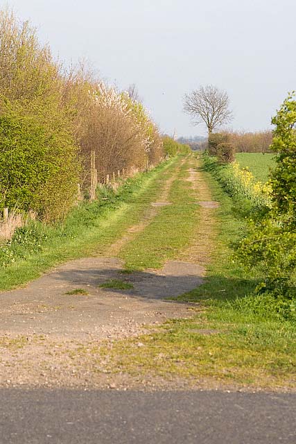
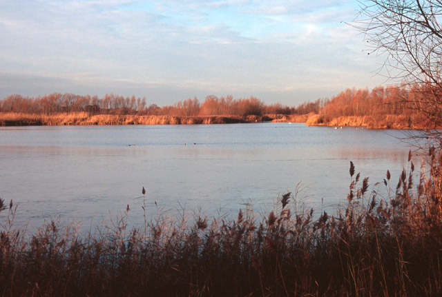
Drayton Lagoon is a picturesque freshwater marsh located in Cambridgeshire, England. Spanning over an area of approximately 10 hectares, it serves as a vital habitat for various flora and fauna. The lagoon consists of a combination of lake, pool, pond, and marshland, creating diverse ecosystems within its boundaries.

Surrounded by lush green vegetation, the lagoon offers a serene and tranquil environment for visitors to enjoy. The water in the lagoon is pristine and crystal clear, providing a perfect habitat for a wide range of aquatic plants and animals. The diverse plant life includes species such as reeds, water lilies, and rushes, which not only enhance the beauty of the lagoon but also provide shelter and food for numerous animal species.

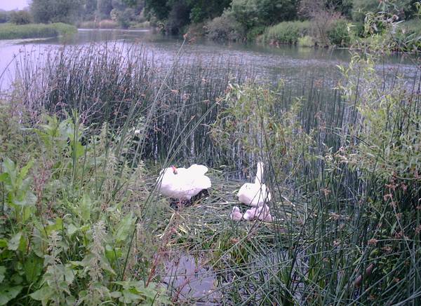
The lagoon is home to a rich variety of bird species, making it a haven for birdwatchers and nature enthusiasts. Visitors can spot majestic birds such as swans, ducks, herons, and various other waterfowl gliding gracefully across the water or nesting in the surrounding vegetation.

The lagoon also supports a diverse range of fish, amphibians, and invertebrates, contributing to the overall biodiversity of the area. These aquatic creatures play a crucial role in maintaining the ecological balance of the lagoon.

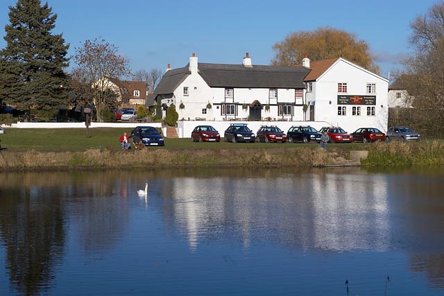
Drayton Lagoon offers several recreational activities for visitors to engage in, including fishing, boating, and wildlife observation. It provides a perfect setting for nature walks and picnics, allowing visitors to immerse themselves in the peaceful ambiance and natural beauty of the lagoon.

Overall, Drayton Lagoon is a remarkable natural treasure in Cambridgeshire, offering a harmonious blend of water bodies and marshland, teeming with wildlife and providing a tranquil retreat for those seeking solace in nature.

If you have any feedback on the listing, please let us know in the comments section below.

Drayton Lagoon Images

Images are sourced within 2km of 52.311599/-0.04198301 or Grid Reference TL3369. Thanks to Geograph Open Source API. All images are credited.

Holywell Church, Cambs Aptly named, there is indeed a holy well within the church grounds, which flows into the nearby Great Ouse.
Holywell Church, Cambs
Aptly named, there is indeed a holy well within the church grounds, which flows into the nearby Great Ouse.
Disused railway bridge across the River Great Ouse near St Ives The railway line has not been used since about 1970 and only the track bed remains in this section. This route is to become a new Guided busway in the future.
Disused railway bridge across the River Great Ouse near St Ives
The railway line has not been used since about 1970 and only the track bed remains in this section. This route is to become a new Guided busway in the future.
The Ferry Boat Inn and Public House, Holywell Reputed to be the oldest Inn/Pub in Cambridgeshire.
The Ferry Boat Inn and Public House, Holywell
Reputed to be the oldest Inn/Pub in Cambridgeshire.
Parson's Drove public footpath Heading towards Holywell from St Ives. The flooded gravel pits are on the right (out of view).
Parson's Drove public footpath
Heading towards Holywell from St Ives. The flooded gravel pits are on the right (out of view).
Conger Lane near Holywell This is where Parson's Drove meets Conger Lane, the latter crossing the stream and heading South as seen in the picture.
Conger Lane near Holywell
This is where Parson's Drove meets Conger Lane, the latter crossing the stream and heading South as seen in the picture.
Conger Lane heading up the hill towards Holywell Conger Lane viewed from the junction with Parson's Drove and the point at which the lane veers South across the stream. At this point it heads up the hill towards Holywell.
Conger Lane heading up the hill towards Holywell
Conger Lane viewed from the junction with Parson's Drove and the point at which the lane veers South across the stream. At this point it heads up the hill towards Holywell.
Conger Lane from Holywell This is where Conger Lane starts/ends at Holywell. From here is goes down the hill with Manor farm fields on the right.
Conger Lane from Holywell
This is where Conger Lane starts/ends at Holywell. From here is goes down the hill with Manor farm fields on the right.
Manor Farm Holywell
Manor Farm Holywell
Footpath and road from Holywell towards Needingworth
Lane to Engineer's Wood and Holywell Spinney
Car Park for Millfield Playing Fields
Allotments near Needingworth
Cemetery near Needingworth
Manor Farm fields, Needingworth
Footpath Alongside one of the gravel pits, there is a good network of public footpaths around Fen Drayton.
Footpath
Alongside one of the gravel pits, there is a good network of public footpaths around Fen Drayton.
River Great Ouse At the mouth of a small stream that passes through the Fen Drayton gravel pit complex.
River Great Ouse
At the mouth of a small stream that passes through the Fen Drayton gravel pit complex.
Male Banded Demoiselle (Calopteryx splendens) Alongside the River Great Ouse, slow flowing rivers with a large amount of aquatic vegetation along the bank are the normal habitat of the Banded Demoiselle, Calopteryx splendens.
Male Banded Demoiselle (Calopteryx splendens)
Alongside the River Great Ouse, slow flowing rivers with a large amount of aquatic vegetation along the bank are the normal habitat of the Banded Demoiselle, Calopteryx splendens.
Ditch through Fen Drayton gravel pits Just as it joins the River Great Ouse. The water levels were quite high after recent rain.
Ditch through Fen Drayton gravel pits
Just as it joins the River Great Ouse. The water levels were quite high after recent rain.
Show me another place!

Drayton Lagoon is located at Grid Ref: TL3369 (Lat: 52.311599, Lng: -0.04198301)

Administrative County: Cambridgeshire

District: South Cambridgeshire

Police Authority: Cambridgeshire

What 3 Words

///hobbit.fears.bulletins. Near Needingworth, Cambridgeshire

Related Wikis

Fen Drayton Lakes

Fen Drayton Lakes is a complex of lakes, lagoons, ponds and a river, situated close to Fen Drayton, Holywell and Swavesey in Cambridgeshire, England. The...

Ouse Valley Way

The Ouse Valley Way is a 150-mile (240 km) footpath in England, following the River Great Ouse from its source near Syresham in Northamptonshire to its...

The Old Ferry Boat Inn

The Old Ferry Boat Inn is a pub in Holywell, Huntingdonshire, Cambridgeshire, England. It is situated on the banks of the River Great Ouse. The Old Ferry...

Holywell, Cambridgeshire

Holywell is a village in Cambridgeshire, England, approximately 6 miles (10 km) east of Huntingdon, in the civil parish of Holywell-cum-Needingworth. It...

Nearby Amenities

Located within 500m of 52.311599,-0.04198301
Barrier: kissing_gate
Bicycle: no
Foot: yes
Horse: no
Motor Vehicle: no
Lat/Long: 52.3121252/-0.0363277
Power: pole
Lat/Long: 52.3153539/-0.0386235
Power: pole
Lat/Long: 52.3157623/-0.0438489
Power: pole
Lat/Long: 52.3156575/-0.0425132
Power: pole
Lat/Long: 52.3154573/-0.0398903
Barrier: kissing_gate
Lat/Long: 52.310335/-0.0467375
Board Type: nature
Information: board
Tourism: information
Lat/Long: 52.3144637/-0.0462951
Leisure: slipway
Lat/Long: 52.3093182/-0.0419658
Tourism: picnic_site
Lat/Long: 52.309793/-0.0457676
Bench
Backrest: yes
Fixme: confirm location (I had no gps)
Lat/Long: 52.3080044/-0.0385558
Parking
Access: permit
Lat/Long: 52.3083014/-0.0372211
Crossing
Lat/Long: 52.3102823/-0.0463244
Bench
Backrest: yes
Material: wood
Seats: 3
Lat/Long: 52.3122071/-0.0349368
Bench
Backrest: yes
Material: wood
Lat/Long: 52.3092786/-0.0420864
Bench
Backrest: yes
Material: wood
Lat/Long: 52.3092551/-0.0419043
Low Hill bowl barrow
Access: private
Archaeological Site: tumulus
Description: The mound of Low Hill barrow, preserved as a prominent earthwork, stands 1m high and covers an area approximately 30m in diameter. Its ditch, from which earth was dug in the construction of the mound, has become infilled and is no longer visible above gro
Historic: archaeological_site
Historic Civilization: neolithic
Lat/Long: 52.3084667/-0.0456721
Bench
Lat/Long: 52.3121795/-0.0373003
Board Type: nature
Information: board
Tourism: information
Lat/Long: 52.3122216/-0.0373397
The data included in this document is from www.openstreetmap.org. The data is made available under ODbL.

Have you been to Drayton Lagoon?

Leave your review of Drayton Lagoon below (or comments, questions and feedback).