Gunwade Lake
Lake, Pool, Pond, Freshwater Marsh in Huntingdonshire
England
Gunwade Lake
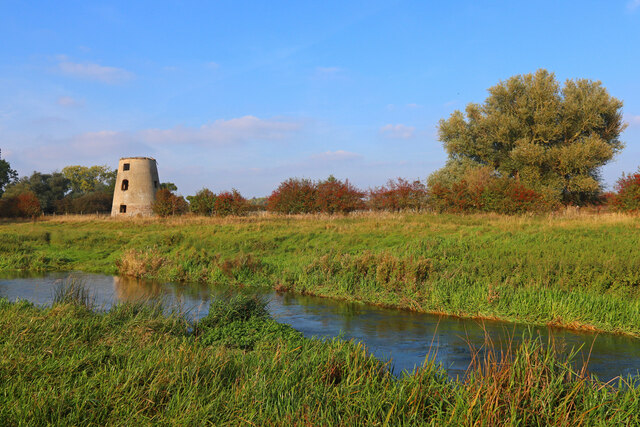
Gunwade Lake is a picturesque freshwater body located in Huntingdonshire, England. Nestled within the tranquil setting of Ferry Meadows Country Park, it serves as a popular recreational destination for locals and tourists alike. Spanning an area of approximately 5 hectares, the lake is a haven for wildlife and offers a range of activities for visitors to enjoy.
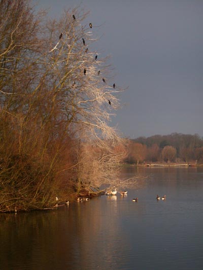
Characterized by its calm and serene atmosphere, Gunwade Lake boasts crystal-clear waters that reflect the surrounding landscape, creating breathtaking views. Surrounded by lush greenery and bordered by reed beds, the lake provides a natural habitat for a diverse array of flora and fauna. Bird enthusiasts will be delighted to spot various species, including swans, ducks, and herons, which frequent the lake's shores.
The lake is well-equipped to cater to outdoor enthusiasts, offering opportunities for fishing, kayaking, and canoeing. Anglers can try their luck at catching a variety of fish species, including carp, pike, and perch. With designated fishing spots and ample space for launching watercraft, Gunwade Lake provides a peaceful environment for both experienced and novice anglers.
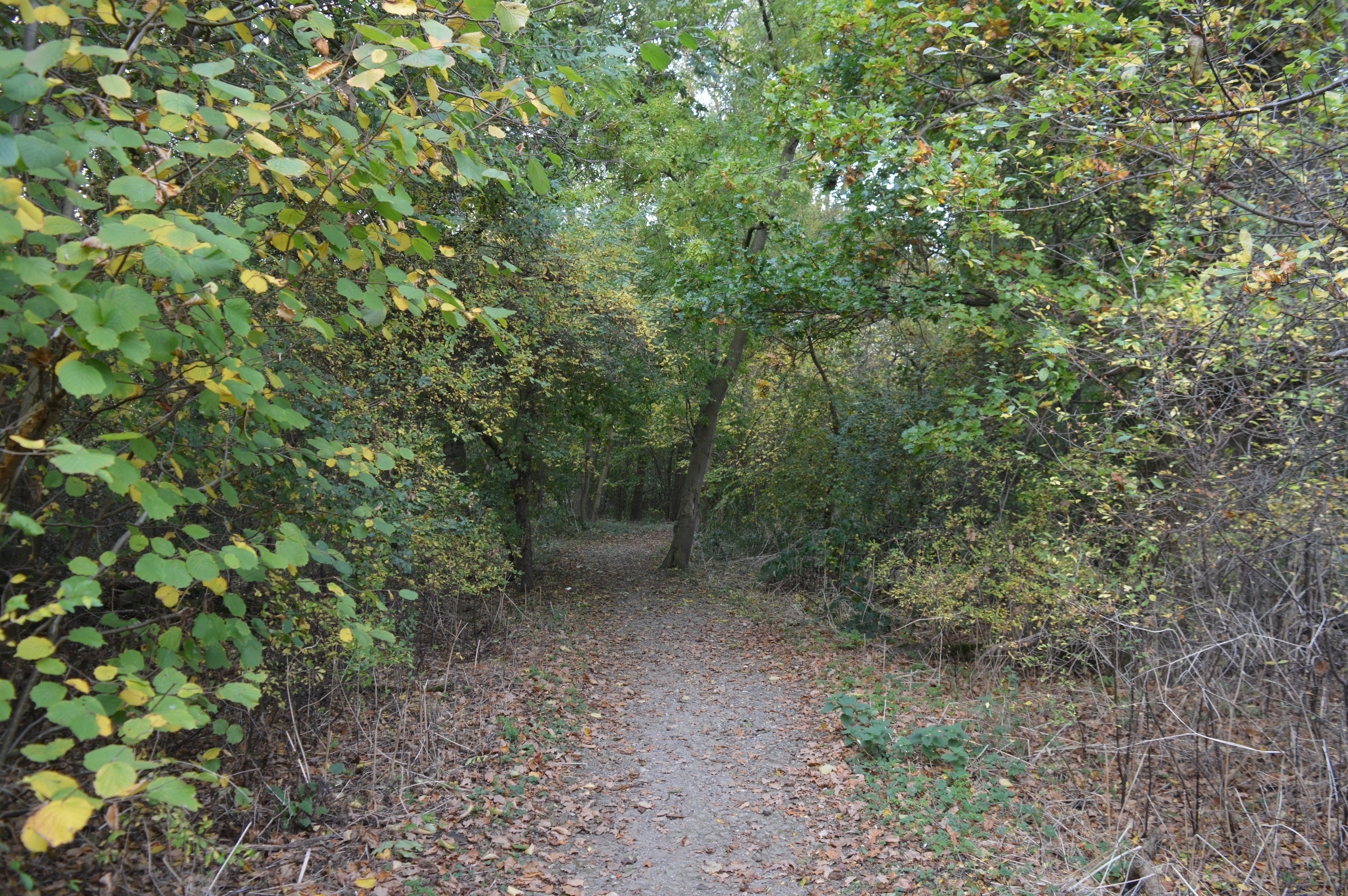
For those seeking a more leisurely experience, Gunwade Lake offers scenic walking trails that wind around its perimeter. The paths provide stunning views of the lake and its surroundings, allowing visitors to immerse themselves in the tranquility of nature. Additionally, benches and picnic areas are conveniently located along the trails, providing the perfect spot to relax and enjoy a picnic or simply soak up the peaceful ambiance.
Gunwade Lake in Huntingdonshire truly offers a slice of paradise for nature lovers and outdoor enthusiasts alike. With its stunning natural beauty and range of recreational activities, it is a must-visit destination for anyone seeking a peaceful retreat in the heart of England.
If you have any feedback on the listing, please let us know in the comments section below.
Gunwade Lake Images
Images are sourced within 2km of 52.56826/-0.31381795 or Grid Reference TL1498. Thanks to Geograph Open Source API. All images are credited.


![Longthorpe houses [3] Number 317 Thorpe Road is built gable end to the street. Constructed in the 18th century of rubble stone with freestone quoins under a thatch roof. There is a modern extension on the left. Listed, grade II, with details at: <span class="nowrap"><a title="https://historicengland.org.uk/listing/the-list/list-entry/1126917" rel="nofollow ugc noopener" href="https://historicengland.org.uk/listing/the-list/list-entry/1126917">Link</a><img style="margin-left:2px;" alt="External link" title="External link - shift click to open in new window" src="https://s1.geograph.org.uk/img/external.png" width="10" height="10"/></span>
Longthorpe is a village in the city of Peterborough, some 2 miles west of the city centre. A Roman fort was established here in the 1st century covering 27 acres, later replaced by another fort of 11 acres. The village is home to Longthorpe Tower, a 14th-century tower and fortified manor house, it contains the finest and most complete set of domestic paintings of the period in northern Europe.](https://s2.geograph.org.uk/geophotos/07/12/49/7124938_f23049ad.jpg)
![Parish church [1] The Anglican parish church of St Botolph was built in the 13th century on the site of an 11th century predecessor. Constructed of rubble stone with freestone quoins under a tile roof. The building was restored in 1869 and most of the fittings are from this date. Listed, grade I, with details at: <span class="nowrap"><a title="https://historicengland.org.uk/listing/the-list/list-entry/1331544" rel="nofollow ugc noopener" href="https://historicengland.org.uk/listing/the-list/list-entry/1331544">Link</a><img style="margin-left:2px;" alt="External link" title="External link - shift click to open in new window" src="https://s1.geograph.org.uk/img/external.png" width="10" height="10"/></span>
Longthorpe is a village in the city of Peterborough, some 2 miles west of the city centre. A Roman fort was established here in the 1st century covering 27 acres, later replaced by another fort of 11 acres. The village is home to Longthorpe Tower, a 14th-century tower and fortified manor house, it contains the finest and most complete set of domestic paintings of the period in northern Europe.](https://s3.geograph.org.uk/geophotos/07/12/49/7124943_98ddc408.jpg)
![Parish church [2] The churchyard. The Anglican parish church of St Botolph was built in the 13th century on the site of an 11th century predecessor. Constructed of rubble stone with freestone quoins under a tile roof. The building was restored in 1869 and most of the fittings are from this date. Listed, grade I, with details at: <span class="nowrap"><a title="https://historicengland.org.uk/listing/the-list/list-entry/1331544" rel="nofollow ugc noopener" href="https://historicengland.org.uk/listing/the-list/list-entry/1331544">Link</a><img style="margin-left:2px;" alt="External link" title="External link - shift click to open in new window" src="https://s1.geograph.org.uk/img/external.png" width="10" height="10"/></span>
Longthorpe is a village in the city of Peterborough, some 2 miles west of the city centre. A Roman fort was established here in the 1st century covering 27 acres, later replaced by another fort of 11 acres. The village is home to Longthorpe Tower, a 14th-century tower and fortified manor house, it contains the finest and most complete set of domestic paintings of the period in northern Europe.](https://s1.geograph.org.uk/geophotos/07/12/49/7124945_37f363ec.jpg)
![Longthorpe houses [5] Numbers 326 and 328 Thorpe Road, are a two 18th century cottages with later, rear additions. Constructed of rubble stone under a thatch roof. Listed, grade II, with details at: <span class="nowrap"><a title="https://historicengland.org.uk/listing/the-list/list-entry/1126921" rel="nofollow ugc noopener" href="https://historicengland.org.uk/listing/the-list/list-entry/1126921">Link</a><img style="margin-left:2px;" alt="External link" title="External link - shift click to open in new window" src="https://s1.geograph.org.uk/img/external.png" width="10" height="10"/></span>
Longthorpe is a village in the city of Peterborough, some 2 miles west of the city centre. A Roman fort was established here in the 1st century covering 27 acres, later replaced by another fort of 11 acres. The village is home to Longthorpe Tower, a 14th-century tower and fortified manor house, it contains the finest and most complete set of domestic paintings of the period in northern Europe.](https://s0.geograph.org.uk/geophotos/07/12/49/7124956_bf710ba9.jpg)
![Longthorpe houses [6] Number 329 Thorpe Road is an 18th century cottage. Constructed of painted rubble stone under a thatch roof. Listed, grade II, with details at: <span class="nowrap"><a title="https://historicengland.org.uk/listing/the-list/list-entry/1331508" rel="nofollow ugc noopener" href="https://historicengland.org.uk/listing/the-list/list-entry/1331508">Link</a><img style="margin-left:2px;" alt="External link" title="External link - shift click to open in new window" src="https://s1.geograph.org.uk/img/external.png" width="10" height="10"/></span>
Longthorpe is a village in the city of Peterborough, some 2 miles west of the city centre. A Roman fort was established here in the 1st century covering 27 acres, later replaced by another fort of 11 acres. The village is home to Longthorpe Tower, a 14th-century tower and fortified manor house, it contains the finest and most complete set of domestic paintings of the period in northern Europe.](https://s2.geograph.org.uk/geophotos/07/12/49/7124958_d960cd89.jpg)
![Longthorpe features [2] A closer look at the thatch figures on the roof of number 329 Thorpe Road <a href="https://www.geograph.org.uk/photo/7124958">TL1698 : Longthorpe houses [6]</a>.
Longthorpe is a village in the city of Peterborough, some 2 miles west of the city centre. A Roman fort was established here in the 1st century covering 27 acres, later replaced by another fort of 11 acres. The village is home to Longthorpe Tower, a 14th-century tower and fortified manor house, it contains the finest and most complete set of domestic paintings of the period in northern Europe.](https://s0.geograph.org.uk/geophotos/07/12/49/7124960_16624ac1.jpg)
![Longthorpe features [3] The gates to Tower House, number 333 Thorpe Road.
Longthorpe is a village in the city of Peterborough, some 2 miles west of the city centre. A Roman fort was established here in the 1st century covering 27 acres, later replaced by another fort of 11 acres. The village is home to Longthorpe Tower, a 14th-century tower and fortified manor house, it contains the finest and most complete set of domestic paintings of the period in northern Europe.](https://s3.geograph.org.uk/geophotos/07/12/49/7124963_a22011b1.jpg)
![Longthorpe Tower [1] Longthorpe Tower was built in the early 14th century as an extension to an existing fortified manor house. The tower has three storeys, is built of stone with walls 6 to 7 feet thick. The first floor was originally designed as living space and contains English medieval wall paintings of religious, secular and moral themes from circa 1330. They were whitewashed around the time of the Reformation and remained hidden until their rediscovery in the 1940s. The tower is listed, grade I, with details at: <span class="nowrap"><a title="https://historicengland.org.uk/listing/the-list/list-entry/1162040" rel="nofollow ugc noopener" href="https://historicengland.org.uk/listing/the-list/list-entry/1162040">Link</a><img style="margin-left:2px;" alt="External link" title="External link - shift click to open in new window" src="https://s1.geograph.org.uk/img/external.png" width="10" height="10"/></span> A Scheduled Ancient Monument with much history and detail at: <span class="nowrap"><a title="https://historicengland.org.uk/listing/the-list/list-entry/1013284" rel="nofollow ugc noopener" href="https://historicengland.org.uk/listing/the-list/list-entry/1013284">Link</a><img style="margin-left:2px;" alt="External link" title="External link - shift click to open in new window" src="https://s1.geograph.org.uk/img/external.png" width="10" height="10"/></span> The tower is in the care of English heritage.
Longthorpe is a village in the city of Peterborough, some 2 miles west of the city centre. A Roman fort was established here in the 1st century covering 27 acres, later replaced by another fort of 11 acres. The village is home to Longthorpe Tower, a 14th-century tower and fortified manor house, it contains the finest and most complete set of domestic paintings of the period in Northern Europe.](https://s0.geograph.org.uk/geophotos/07/12/49/7124976_f58e1197.jpg)
![Longthorpe Tower [2] Longthorpe Tower was built in the early 14th century as an extension to an existing fortified manor house. The tower has three storeys, is built of stone with walls 6 to 7 feet thick. The first floor was originally designed as living space and contains English medieval wall paintings of religious, secular and moral themes from circa 1330. They were whitewashed around the time of the Reformation and remained hidden until their rediscovery in the 1940s. The tower is listed, grade I, with details at: <span class="nowrap"><a title="https://historicengland.org.uk/listing/the-list/list-entry/1162040" rel="nofollow ugc noopener" href="https://historicengland.org.uk/listing/the-list/list-entry/1162040">Link</a><img style="margin-left:2px;" alt="External link" title="External link - shift click to open in new window" src="https://s1.geograph.org.uk/img/external.png" width="10" height="10"/></span> A Scheduled Ancient Monument with much history and detail at: <span class="nowrap"><a title="https://historicengland.org.uk/listing/the-list/list-entry/1013284" rel="nofollow ugc noopener" href="https://historicengland.org.uk/listing/the-list/list-entry/1013284">Link</a><img style="margin-left:2px;" alt="External link" title="External link - shift click to open in new window" src="https://s1.geograph.org.uk/img/external.png" width="10" height="10"/></span> The tower is in the care of English heritage.
Longthorpe is a village in the city of Peterborough, some 2 miles west of the city centre. A Roman fort was established here in the 1st century covering 27 acres, later replaced by another fort of 11 acres. The village is home to Longthorpe Tower, a 14th-century tower and fortified manor house, it contains the finest and most complete set of domestic paintings of the period in Northern Europe.](https://s3.geograph.org.uk/geophotos/07/12/49/7124983_98f24ee8.jpg)
![Longthorpe Tower [3] Longthorpe Tower was built in the early 14th century as an extension to an existing fortified manor house. The tower has three storeys, is built of stone with walls 6 to 7 feet thick. The first floor was originally designed as living space and contains English medieval wall paintings of religious, secular and moral themes from circa 1330. They were whitewashed around the time of the Reformation and remained hidden until their rediscovery in the 1940s. The tower is listed, grade I, with details at: <span class="nowrap"><a title="https://historicengland.org.uk/listing/the-list/list-entry/1162040" rel="nofollow ugc noopener" href="https://historicengland.org.uk/listing/the-list/list-entry/1162040">Link</a><img style="margin-left:2px;" alt="External link" title="External link - shift click to open in new window" src="https://s1.geograph.org.uk/img/external.png" width="10" height="10"/></span> A Scheduled Ancient Monument with much history and detail at: <span class="nowrap"><a title="https://historicengland.org.uk/listing/the-list/list-entry/1013284" rel="nofollow ugc noopener" href="https://historicengland.org.uk/listing/the-list/list-entry/1013284">Link</a><img style="margin-left:2px;" alt="External link" title="External link - shift click to open in new window" src="https://s1.geograph.org.uk/img/external.png" width="10" height="10"/></span> The tower is in the care of English heritage.
Longthorpe is a village in the city of Peterborough, some 2 miles west of the city centre. A Roman fort was established here in the 1st century covering 27 acres, later replaced by another fort of 11 acres. The village is home to Longthorpe Tower, a 14th-century tower and fortified manor house, it contains the finest and most complete set of domestic paintings of the period in Northern Europe.](https://s1.geograph.org.uk/geophotos/07/12/49/7124985_d043332e.jpg)
![Longthorpe Tower [4] Longthorpe Tower was built in the early 14th century as an extension to an existing fortified manor house. The tower has three storeys, is built of stone with walls 6 to 7 feet thick. The first floor was originally designed as living space and contains English medieval wall paintings of religious, secular and moral themes from circa 1330. They were whitewashed around the time of the Reformation and remained hidden until their rediscovery in the 1940s. The tower is listed, grade I, with details at: <span class="nowrap"><a title="https://historicengland.org.uk/listing/the-list/list-entry/1162040" rel="nofollow ugc noopener" href="https://historicengland.org.uk/listing/the-list/list-entry/1162040">Link</a><img style="margin-left:2px;" alt="External link" title="External link - shift click to open in new window" src="https://s1.geograph.org.uk/img/external.png" width="10" height="10"/></span> A Scheduled Ancient Monument with much history and detail at: <span class="nowrap"><a title="https://historicengland.org.uk/listing/the-list/list-entry/1013284" rel="nofollow ugc noopener" href="https://historicengland.org.uk/listing/the-list/list-entry/1013284">Link</a><img style="margin-left:2px;" alt="External link" title="External link - shift click to open in new window" src="https://s1.geograph.org.uk/img/external.png" width="10" height="10"/></span> The tower is in the care of English heritage.
Longthorpe is a village in the city of Peterborough, some 2 miles west of the city centre. A Roman fort was established here in the 1st century covering 27 acres, later replaced by another fort of 11 acres. The village is home to Longthorpe Tower, a 14th-century tower and fortified manor house, it contains the finest and most complete set of domestic paintings of the period in Northern Europe.](https://s2.geograph.org.uk/geophotos/07/12/49/7124986_b0f9dee8.jpg)
Gunwade Lake is located at Grid Ref: TL1498 (Lat: 52.56826, Lng: -0.31381795)
Unitary Authority: Peterborough
Police Authority: Cambridgeshire
What 3 Words
///debate.props.ready. Near Castor, Cambridgeshire
Nearby Locations
Related Wikis
Nene Park, Peterborough
Nene Park is a country park in the city of Peterborough, Cambridgeshire in the United Kingdom. Opened in 1978, it occupies a site approximately three and...

Ferry Meadows railway station
Ferry Meadows is a station on the Nene Valley Railway between Wansford and Orton Mere. The current station has one platform, and has no car park of its...
Thorpe Wood
Thorpe Wood is a 10 hectare nature reserve on the western outskirts of Peterborough in Cambridgeshire. It is managed by the Wildlife Trust for Bedfordshire...

Greatest Hits Radio South
Greatest Hits Radio South is a regional radio station serving the South of England, as part of Bauer’s Greatest Hits Radio network. == Coverage == The...

Milton Hall
Milton Hall near Peterborough, is the largest private house in Cambridgeshire, England. As part of the Soke of Peterborough, it was formerly part of Northamptonshire...

Nene Valley Railway
The Nene Valley Railway (NVR) is a preserved railway in Cambridgeshire, England, running between Peterborough Nene Valley and Yarwell Junction. The line...
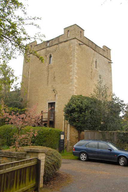
Longthorpe Tower
Longthorpe Tower is a 14th-century three-storey tower in the Longthorpe area of Peterborough, Cambridgeshire, England. It is famous for its well-preserved...

Castor, Cambridgeshire
Castor is a village and civil parish in the City of Peterborough unitary authority, about 4 miles (6.4 km) west of the city centre. The parish is part...
Nearby Amenities
Located within 500m of 52.56826,-0.31381795Have you been to Gunwade Lake?
Leave your review of Gunwade Lake below (or comments, questions and feedback).