Ash Holt Reservoir

Lake, Pool, Pond, Freshwater Marsh in Lincolnshire

England

Ash Holt Reservoir

Cut Mark: Cleatham, Cleatham Hall Farm Cut bench mark on the south-east angle of a large farm building at Cleatham Hall Farm.  See <a title="https://www.geograph.org.uk/photo/7332574" href="https://www.geograph.org.uk/photo/7332574">Link</a> for a wider view and <span class="nowrap"><a title="https://www.bench-marks.org.uk/bm179252" rel="nofollow ugc noopener" href="https://www.bench-marks.org.uk/bm179252">Link</a><img style="margin-left:2px;" alt="External link" title="External link - shift click to open in new window" src="https://s1.geograph.org.uk/img/external.png" width="10" height="10"/></span> for details of the mark.
Cut Mark: Cleatham, Cleatham Hall Farm Credit: Brian Westlake

Ash Holt Reservoir, located in Lincolnshire, is a picturesque freshwater marsh that offers a serene and tranquil environment for nature enthusiasts. Covering an area of approximately 10 acres, it is a relatively small body of water, often referred to as a lake, pool, or pond.

The reservoir is nestled within the beautiful Ash Holt Nature Reserve, which spans over 100 acres and is known for its diverse range of flora and fauna. The surrounding area is primarily made up of marshland, making it an ideal habitat for various water birds, including herons, ducks, and swans. These birds can often be spotted gracefully gliding across the water's surface or nesting in the nearby reed beds.

The reservoir itself is fed by natural springs and small streams that meander through the reserve, ensuring a constant supply of fresh water. Its crystal-clear waters are home to a variety of fish species, such as perch, roach, and tench, making it a popular spot for anglers.

Visitors to Ash Holt Reservoir can enjoy a range of activities, including birdwatching, fishing, and leisurely walks along the designated footpaths that encircle the water. The reserve boasts several viewing platforms strategically placed to offer stunning vistas of the reservoir and its inhabitants.

Overall, Ash Holt Reservoir is a haven for nature lovers, providing a peaceful retreat where visitors can immerse themselves in the beauty of Lincolnshire's natural landscape.

If you have any feedback on the listing, please let us know in the comments section below.

Ash Holt Reservoir Images

Images are sourced within 2km of 53.499734/-0.58561106 or Grid Reference SE9301. Thanks to Geograph Open Source API. All images are credited.

Cut Mark: Cleatham, Cleatham Hall Farm Cut bench mark on the south-east angle of a large farm building at Cleatham Hall Farm.  See <a title="https://www.geograph.org.uk/photo/7332574" href="https://www.geograph.org.uk/photo/7332574">Link</a> for a wider view and <span class="nowrap"><a title="https://www.bench-marks.org.uk/bm179252" rel="nofollow ugc noopener" href="https://www.bench-marks.org.uk/bm179252">Link</a><img style="margin-left:2px;" alt="External link" title="External link - shift click to open in new window" src="https://s1.geograph.org.uk/img/external.png" width="10" height="10"/></span> for details of the mark.
Cut Mark: Cleatham, Cleatham Hall Farm
Cut bench mark on the south-east angle of a large farm building at Cleatham Hall Farm. See Link for a wider view and LinkExternal link for details of the mark.
Farm Building at Cleatham Hall Farm There is a cut bench mark on the near angle of this large farm building at Cleatham Hall Farm.  See <a title="https://www.geograph.org.uk/photo/7332571" href="https://www.geograph.org.uk/photo/7332571">Link</a> for a closer view and <span class="nowrap"><a title="https://www.bench-marks.org.uk/bm179252" rel="nofollow ugc noopener" href="https://www.bench-marks.org.uk/bm179252">Link</a><img style="margin-left:2px;" alt="External link" title="External link - shift click to open in new window" src="https://s1.geograph.org.uk/img/external.png" width="10" height="10"/></span> for details of the mark.
Farm Building at Cleatham Hall Farm
There is a cut bench mark on the near angle of this large farm building at Cleatham Hall Farm. See Link for a closer view and LinkExternal link for details of the mark.
Cut Mark on a House at the Junction of Cleatham Road and Manton Road This benchmark is on the angle of the house at the road junction.  It is not listed by the Ordnance Survey but appears on old maps up to 1961.  See <a title="https://www.geograph.org.uk/photo/7332596" href="https://www.geograph.org.uk/photo/7332596">Link</a> for a building view and <span class="nowrap"><a title="https://www.bench-marks.org.uk/bm179254" rel="nofollow ugc noopener" href="https://www.bench-marks.org.uk/bm179254">Link</a><img style="margin-left:2px;" alt="External link" title="External link - shift click to open in new window" src="https://s1.geograph.org.uk/img/external.png" width="10" height="10"/></span> for details of the mark.
Cut Mark on a House at the Junction of Cleatham Road and Manton Road
This benchmark is on the angle of the house at the road junction. It is not listed by the Ordnance Survey but appears on old maps up to 1961. See Link for a building view and LinkExternal link for details of the mark.
House at the Junction of Cleatham Road and Manton Road There is a benchmark is on the angle of the house at the road junction.  It is not listed by the Ordnance Survey but appears on old maps up to 1961.  See <a title="https://www.geograph.org.uk/photo/7332592" href="https://www.geograph.org.uk/photo/7332592">Link</a> for a close view and <span class="nowrap"><a title="https://www.bench-marks.org.uk/bm179254" rel="nofollow ugc noopener" href="https://www.bench-marks.org.uk/bm179254">Link</a><img style="margin-left:2px;" alt="External link" title="External link - shift click to open in new window" src="https://s1.geograph.org.uk/img/external.png" width="10" height="10"/></span> for details of the mark.
House at the Junction of Cleatham Road and Manton Road
There is a benchmark is on the angle of the house at the road junction. It is not listed by the Ordnance Survey but appears on old maps up to 1961. See Link for a close view and LinkExternal link for details of the mark.
Ventilation Shaft above Kirton Tunnel A ventilation shaft for Kirton Tunnel, with a substantial metal grid on top.  There is a line of now tree-covered spoil from the tunnel's excavation, running to the north-east above the line of the tunnel.  Ventilation shafts were probably used to bring spoil to the surface.
Ventilation Shaft above Kirton Tunnel
A ventilation shaft for Kirton Tunnel, with a substantial metal grid on top. There is a line of now tree-covered spoil from the tunnel's excavation, running to the north-east above the line of the tunnel. Ventilation shafts were probably used to bring spoil to the surface.
Track to Gainsthorpe Medieval Village
Gainsthorpe Medieval Village
Kirton Lime Sidings and Lime Kiln: aerial 2023 See <a href="https://www.geograph.org.uk/photo/5985774">SE9401 : Train through Kirton Lime Sidings and passing the Lime Kiln</a>, <span class="nowrap"><a title="https://www.heritagegateway.org.uk/Gateway/Results_Single.aspx?uid=MLS9265&resourceID=1034" rel="nofollow ugc noopener" href="https://www.heritagegateway.org.uk/Gateway/Results_Single.aspx?uid=MLS9265&resourceID=1034">Link</a><img style="margin-left:2px;" alt="External link" title="External link - shift click to open in new window" src="https://s1.geograph.org.uk/img/external.png" width="10" height="10"/></span> and 
<span class="nowrap"><a title="https://www.cementkilns.co.uk/cement_kiln_kirton_lindsey.html" rel="nofollow ugc noopener" href="https://www.cementkilns.co.uk/cement_kiln_kirton_lindsey.html">Link</a><img style="margin-left:2px;" alt="External link" title="External link - shift click to open in new window" src="https://s1.geograph.org.uk/img/external.png" width="10" height="10"/></span>
Kirton Lime Sidings and Lime Kiln: aerial 2023
Rail bridge on Cleatham Road, Kirton Lindsey
Footpath across railway lines. Close to Kirton in lindsey station.
Footpath across railway lines.
Close to Kirton in lindsey station.
Cut bench mark on Kirton in Lindsey railway bridge Cut bench mark on the north-west face of the north-east abutment.  See <a title="https://www.geograph.org.uk/photo/6270974" href="https://www.geograph.org.uk/photo/6270974">Link</a> for a wider view and <span class="nowrap"><a title="https://www.bench-marks.org.uk/bm111516" rel="nofollow ugc noopener" href="https://www.bench-marks.org.uk/bm111516">Link</a><img style="margin-left:2px;" alt="External link" title="External link - shift click to open in new window" src="https://s1.geograph.org.uk/img/external.png" width="10" height="10"/></span> for details.
Cut bench mark on Kirton in Lindsey railway bridge
Cut bench mark on the north-west face of the north-east abutment. See Link for a wider view and LinkExternal link for details.
Kirton in Lindsey railway bridge This bridge has had a major rebuild but still retains a cut bench mark on the face below the identification sign.  See <a title="https://www.geograph.org.uk/photo/6270966" href="https://www.geograph.org.uk/photo/6270966">Link</a> for a closer view and <span class="nowrap"><a title="https://www.bench-marks.org.uk/bm111516" rel="nofollow ugc noopener" href="https://www.bench-marks.org.uk/bm111516">Link</a><img style="margin-left:2px;" alt="External link" title="External link - shift click to open in new window" src="https://s1.geograph.org.uk/img/external.png" width="10" height="10"/></span> for details of the benchmark.
Kirton in Lindsey railway bridge
This bridge has had a major rebuild but still retains a cut bench mark on the face below the identification sign. See Link for a closer view and LinkExternal link for details of the benchmark.
Kirton Lindsey station A spring was rising between the tracks behind the camera and the stream ran through the platform before draining away through the ballast and down the embankment. 

3 trains in each direction on Saturdays only from Sheffield to Cleethorpes.

The town is called Kirton in Lindsey
Kirton Lindsey station
A spring was rising between the tracks behind the camera and the stream ran through the platform before draining away through the ballast and down the embankment. 3 trains in each direction on Saturdays only from Sheffield to Cleethorpes. The town is called Kirton in Lindsey
Kirton Lindsey station A spring was rising between the tracks and the stream ran through the platform before draining away through the ballast and down the embankment.

3 trains in each direction on Saturdays only from Sheffield to Cleethorpes.

The town is called Kirton in Lindsey
Kirton Lindsey station
A spring was rising between the tracks and the stream ran through the platform before draining away through the ballast and down the embankment. 3 trains in each direction on Saturdays only from Sheffield to Cleethorpes. The town is called Kirton in Lindsey
Mount Pleasant Mill, Kirton in Lindsey Sadly without sails, apparently lost in a gale a few years ago.
Mount Pleasant Mill, Kirton in Lindsey
Sadly without sails, apparently lost in a gale a few years ago.
Track by Northcliffe Farm
Mount Pleasant Windmill, North Cliff Road, Kirton-in-Lindsey Grade II Listed windmill with lintel marked 'E L 1875'. The mill was built for Edric Lansdall on the remaining roundhouse of a post-mill reportedly blown down two years earlier. It was wind powered until 1933 and by a diesel single cylinder Crossley engine until 1973. The sails were removed in 1936 and were not replaced until 1991 when a full restoration was carried out. The original cap with the oak cap frame is still in place. By 1881 the miller was Rupert Snell succeeded by his son Charles between 1913 and 1919 who sold the mill in 1936 to the Banks brothers. In 1973, when the Banks brothers decided to retire, the property was sold to Alan Turner who used the grounds to operate a Railway Museum. In 1991, the windmill was renovated by the new owners, Pat and Jane White with the help of grants from English Heritage and Glanford Borough Council. It changed hands again in August 2000. On 29 November 2015 the windmill was severely damaged by high winds, causing two of the sails and the tail-fan to be torn off.
Mount Pleasant Windmill, North Cliff Road, Kirton-in-Lindsey
Grade II Listed windmill with lintel marked 'E L 1875'. The mill was built for Edric Lansdall on the remaining roundhouse of a post-mill reportedly blown down two years earlier. It was wind powered until 1933 and by a diesel single cylinder Crossley engine until 1973. The sails were removed in 1936 and were not replaced until 1991 when a full restoration was carried out. The original cap with the oak cap frame is still in place. By 1881 the miller was Rupert Snell succeeded by his son Charles between 1913 and 1919 who sold the mill in 1936 to the Banks brothers. In 1973, when the Banks brothers decided to retire, the property was sold to Alan Turner who used the grounds to operate a Railway Museum. In 1991, the windmill was renovated by the new owners, Pat and Jane White with the help of grants from English Heritage and Glanford Borough Council. It changed hands again in August 2000. On 29 November 2015 the windmill was severely damaged by high winds, causing two of the sails and the tail-fan to be torn off.
Kirton in Lindsey Station Grade II listed station building and Stationmaster's house, now a private dwelling built 1849 for Manchester, Sheffield and Lincolnshire Railway. A limited service runs only on a Saturday.
Kirton in Lindsey Station
Grade II listed station building and Stationmaster's house, now a private dwelling built 1849 for Manchester, Sheffield and Lincolnshire Railway. A limited service runs only on a Saturday.
Show me another place!

Ash Holt Reservoir is located at Grid Ref: SE9301 (Lat: 53.499734, Lng: -0.58561106)

Unitary Authority: North Lincolnshire

Police Authority: Humberside

What 3 Words

///months.amplifier.decorate. Near Manton, Lincolnshire

Nearby Locations

Ash Holt Reservoir

Related Wikis

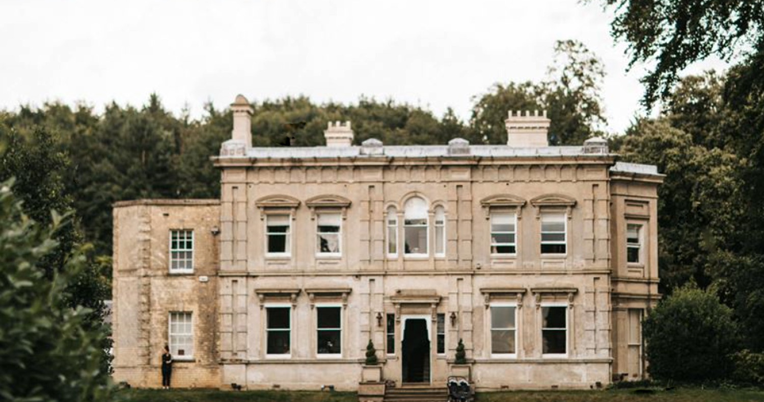
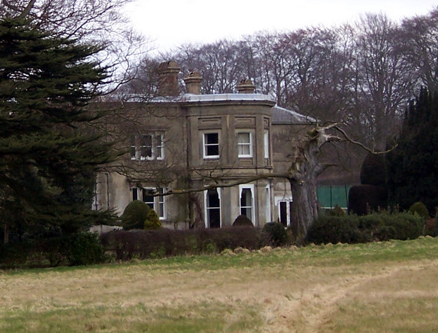
Cleatham Hall, Lincolnshire

Cleatham Hall is an English country house located near Manton in Lincolnshire, England. The building is of special interest and has a Grade II listing...

Scunthorpe (UK Parliament constituency)

Scunthorpe is a constituency represented in the House of Commons of the UK Parliament since 2019 by Holly Mumby-Croft, a member of the Conservative Party...

Manton, Lincolnshire

Manton is a village and civil parish in North Lincolnshire, England. The population of the civil parish at the 2011 census was 123. The village is situated...
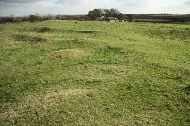
Gainsthorpe

Gainsthorpe is a deserted medieval village (DMV) site in a field which is part of the present Gainsthorpe Farm in Lincolnshire, England. The site is in...

Nearby Amenities

Located within 500m of 53.499734,-0.58561106
Ele: 73
Lat/Long: 53.4984357/-0.5835349
Quarry Fields Farm
Place: farm
Source: Bing
Lat/Long: 53.5016532/-0.5868348
The data included in this document is from www.openstreetmap.org. The data is made available under ODbL.

Have you been to Ash Holt Reservoir?

Leave your review of Ash Holt Reservoir below (or comments, questions and feedback).