Cauldwell Dam

Lake, Pool, Pond, Freshwater Marsh in Nottinghamshire Ashfield

England

Cauldwell Dam

King's Mill Viaduct Same view as <a href="https://www.geograph.org.uk/photo/856918">SK5159 : Kings Mill Viaduct</a> taken 13 years later
King's Mill Viaduct Credit: Antony Dixon

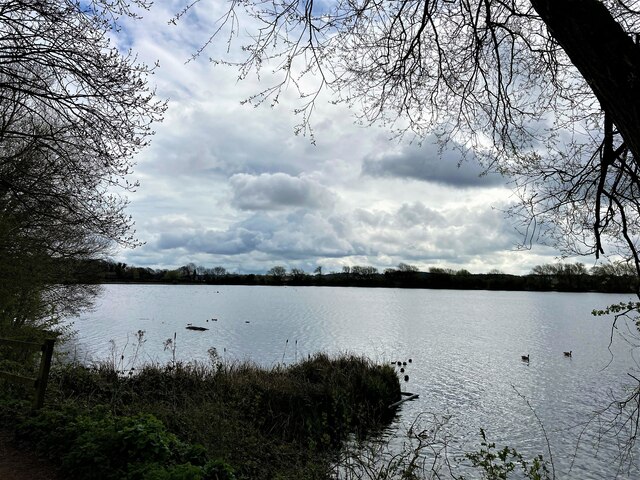
Cauldwell Dam, located in Nottinghamshire, is a freshwater marsh that encompasses a lake, pool, and pond within its boundaries. Situated in a picturesque setting, this natural wonder is a haven for wildlife and offers stunning views to visitors.

The main feature of Cauldwell Dam is its expansive lake, which covers a considerable area. The lake is fed by various water sources, including streams, rivers, and rainfall runoff. It is teeming with a rich array of aquatic life, such as fish, frogs, and waterfowl. The serene surface of the lake reflects the surrounding vegetation and sky, creating a tranquil atmosphere.

Adjacent to the lake is a pool, a smaller body of water that provides a shallow habitat for aquatic plants and animals. The pool is frequented by smaller species of fish and amphibians, making it an ideal spot for observing and studying these creatures in their natural habitat.

The pond within Cauldwell Dam is a smaller water feature, secluded and brimming with biodiversity. It serves as a breeding ground for various water insects and amphibians, contributing to the overall ecological health of the area.

Surrounding the water bodies, the freshwater marsh is a vital ecosystem that supports a diverse range of plant and animal species. It consists of wetland vegetation, including reeds, sedges, and grasses, which act as a natural filter, improving water quality and providing habitats for many different species.

Cauldwell Dam in Nottinghamshire offers a unique opportunity for nature enthusiasts to immerse themselves in a thriving freshwater ecosystem. From the expansive lake to the smaller pool and pond, this area is a testament to the beauty and importance of preserving natural habitats.

If you have any feedback on the listing, please let us know in the comments section below.

Cauldwell Dam Images

Images are sourced within 2km of 53.120336/-1.2078342 or Grid Reference SK5358. Thanks to Geograph Open Source API. All images are credited.

King's Mill Viaduct Same view as <a href="https://www.geograph.org.uk/photo/856918">SK5159 : Kings Mill Viaduct</a> taken 13 years later
King's Mill Viaduct
Same view as SK5159 : Kings Mill Viaduct taken 13 years later
King's Mill information board (part 2)
King's Mill information board (part 1)
Photo from King's Mill information board Shows King's Mill as it appeared in about 1900
Photo from King's Mill information board
Shows King's Mill as it appeared in about 1900
King's Mill recreated This rather clever information board gives an impression of the view from this spot about 1900
King's Mill recreated
This rather clever information board gives an impression of the view from this spot about 1900
Equestrian bridge at King's Mill This bridge was built to replace a small level crossing following a fatal accident.
The site of the crossing can be seen on the very edge of the photo, to the right of the house.
Equestrian bridge at King's Mill
This bridge was built to replace a small level crossing following a fatal accident. The site of the crossing can be seen on the very edge of the photo, to the right of the house.
Small park off Waverley Road, Mansfield
Tree on Berry Hill Road
William Singleton Almshouses, Waverley Road, Mansfield Designed by F.W. Tempest 1936. One of three linked buildings.
William Singleton Almshouses, Waverley Road, Mansfield
Designed by F.W. Tempest 1936. One of three linked buildings.
Houses in Waverley Road, Mansfield
Kings Mill Reservoir in Mansfield
Crop Fields near Sutton-In-Ashfield Path and farmland to the south east of the town. The footpath skirts this wheat field's right periphery.
Crop Fields near Sutton-In-Ashfield
Path and farmland to the south east of the town. The footpath skirts this wheat field's right periphery.
Crop Field Patchwork Wheat Fields located to the south east of Sutton-in-Ashfield
Crop Field Patchwork
Wheat Fields located to the south east of Sutton-in-Ashfield
Footpath and Fields near Windmill Hill The Kirkby-in-Ashfield conurbation can be seen in the distance.
Footpath and Fields near Windmill Hill
The Kirkby-in-Ashfield conurbation can be seen in the distance.
Sherwood Observatory Operated by Mansfield and Sutton Astrological Society and home to a 61 centimetre Newtonian telescope. The observatory hosts occasional open days and run basic accredited astronomy courses in addition to group visits by arrangement. This picture was taken from a nearby derelict structure which stands at a slightly higher elevation to the observatory itself.
Sherwood Observatory
Operated by Mansfield and Sutton Astrological Society and home to a 61 centimetre Newtonian telescope. The observatory hosts occasional open days and run basic accredited astronomy courses in addition to group visits by arrangement. This picture was taken from a nearby derelict structure which stands at a slightly higher elevation to the observatory itself.
Countryside and Distribution Centre near Sutton This is EMA2 - a new and highly automised Amazon Fulfillment Centre which opened in late 2020. Surrounded by prime countryside it's pictured from a field entrance off the B6139 Coxmoor Road at the extreme south west corner of the grid square.
Countryside and Distribution Centre near Sutton
This is EMA2 - a new and highly automised Amazon Fulfillment Centre which opened in late 2020. Surrounded by prime countryside it's pictured from a field entrance off the B6139 Coxmoor Road at the extreme south west corner of the grid square.
B6139 Coxmoor Road Looking north west from a narrow roadside path.
B6139 Coxmoor Road
Looking north west from a narrow roadside path.
Crossroads near Coxmoor Farm The A611 Derby Road intersects the B6139 Coxmoor Road here.
Crossroads near Coxmoor Farm
The A611 Derby Road intersects the B6139 Coxmoor Road here.
Show me another place!

Cauldwell Dam is located at Grid Ref: SK5358 (Lat: 53.120336, Lng: -1.2078342)

Administrative County: Nottinghamshire

District: Ashfield

Police Authority: Nottinghamshire

What 3 Words

///sling.gates.purple. Near Mansfield, Nottinghamshire

Related Wikis

Sherwood Observatory

Sherwood Observatory is an amateur astronomical observatory in Nottinghamshire, England, owned and operated by Mansfield and Sutton Astronomical Society...

Mansfield and Sutton Astronomical Society

Mansfield and Sutton Astronomical Society (MSAS) is an amateur astronomical society in the East Midlands of England. It was formed in 1969. It is based...

Mansfield and Pinxton Railway

The Mansfield and Pinxton Railway was an early horse-drawn railway in the United Kingdom. It was completed in 1819, to make a transport link between Mansfield...

Field Mill

Field Mill, currently known as One Call Stadium for sponsorship reasons, is a football ground in Mansfield, Nottinghamshire, England, and the home of Mansfield...

St Mark's Church, Mansfield

St. Mark's Church is on Nottingham Road, Mansfield, Nottinghamshire, England. It is an active Church of England parish church in the deanery of Mansfield...

Sutton Junction railway station

Sutton Junction railway station was a station in Sutton-in-Ashfield, Nottinghamshire, England. It was opened in 1850, and was located on the Midland Railway...

Mansfield urban area

The Mansfield Urban Area is a built-up area of Nottinghamshire, England. Which comprises the towns of Mansfield, Sutton in Ashfield, and Kirkby in Ashfield...

Mansfield (UK Parliament constituency)

Mansfield is a constituency created in 1885 represented in the House of Commons of the UK Parliament since 2017 by Ben Bradley of the Conservative Party...

Nearby Amenities

Located within 500m of 53.120336,-1.2078342
Barrier: bollard
Lat/Long: 53.1199274/-1.2031874
Barrier: block
Lat/Long: 53.1205003/-1.2060144
The data included in this document is from www.openstreetmap.org. The data is made available under ODbL.

Have you been to Cauldwell Dam?

Leave your review of Cauldwell Dam below (or comments, questions and feedback).