Broadlands Lake

Lake, Pool, Pond, Freshwater Marsh in Hampshire Test Valley

England

Broadlands Lake

Nursling : M27 Motorway Looking along the M27 motorway.
Nursling : M27 Motorway Credit: Lewis Clarke

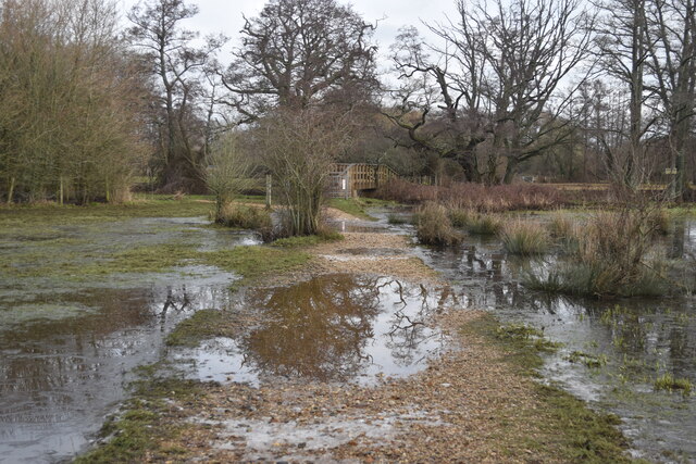
Broadlands Lake is a picturesque freshwater body located in Hampshire, England. Covering an area of approximately 25 acres, it is classified as both a lake and a pond due to its size and characteristics. The lake is privately owned but open to the public, offering a tranquil and scenic environment for visitors to enjoy.

Surrounded by lush greenery and nestled within the grounds of the historic Broadlands Estate, this natural freshwater marsh boasts an abundance of wildlife and vegetation. The lake is home to various species of fish, including carp, pike, and roach, making it a popular spot for anglers seeking a rewarding fishing experience.

Visitors can explore the lake by foot, following the well-maintained footpaths that wind their way along its banks. The peaceful ambience of the lake attracts nature enthusiasts, who can observe a diverse range of birdlife, such as swans, ducks, herons, and kingfishers.

The water in Broadlands Lake is crystal clear and inviting, making it suitable for a variety of water-based activities. Kayaking and paddleboarding are popular pastimes, allowing visitors to experience the lake's serene surroundings from a different perspective. Swimming, however, is not permitted due to safety concerns and to preserve the ecosystem.

Overall, Broadlands Lake offers a tranquil retreat from the hustle and bustle of everyday life. Whether one wishes to indulge in a peaceful walk, observe wildlife, or engage in fishing or water sports, this beautiful freshwater marsh provides a serene and idyllic setting for all.

If you have any feedback on the listing, please let us know in the comments section below.

Broadlands Lake Images

Images are sourced within 2km of 50.944357/-1.5041576 or Grid Reference SU3416. Thanks to Geograph Open Source API. All images are credited.

Nursling : M27 Motorway Looking along the M27 motorway.
Nursling : M27 Motorway
Looking along the M27 motorway.
Matrix board - M27 southbound
Roadbridge - M27 southbound
Footbridge - M27 southbound
A36 crossing M27
A36 crossing M27
Roadbridge over M27
Roadbridge over M27
Storage tank, Nursling Industrial Estate
A326 northwards towards M27 The  A36 crosses the bridge, there is full interchange here.
A326 northwards towards M27
The A36 crosses the bridge, there is full interchange here.
Flooded path towards footbridge, Testwood Lakes Local water levels have been much higher in the last few days: the path is now almost uncovered again.
Flooded path towards footbridge, Testwood Lakes
Local water levels have been much higher in the last few days: the path is now almost uncovered again.
Nursling Mill The water level is quite high, with the nearby river channel almost bankfull.
Nursling Mill
The water level is quite high, with the nearby river channel almost bankfull.
One of several channels of the River Test, north of Mill Lane
Evidence of former transport infrastructure, Nursling Standing next to the former Andover Canal <a href="https://www.geograph.org.uk/photo/1729360">SU3615 : Section of Andover Canal</a>, this house is at the end of Station Road, itself named after the former Nursling station <a href="https://www.geograph.org.uk/photo/5260478">SU3616 : View past former railway station, Nursling</a>. The bridge crosses a stream, not the canal route itself.
Evidence of former transport infrastructure, Nursling
Standing next to the former Andover Canal SU3615 : Section of Andover Canal, this house is at the end of Station Road, itself named after the former Nursling station SU3616 : View past former railway station, Nursling. The bridge crosses a stream, not the canal route itself.
Buildings at Church Farm Former farm buildings mostly in use as small business units.
Buildings at Church Farm
Former farm buildings mostly in use as small business units.
Flooded field beside the M27 These fields form part of the floodplain of the Rivers Test and Blackwater and frequently flood in winter. The main river channels pass through separate bridges, but this southeastern corner is drained via an underpass beneath the motorway embankment which contains an access track above a culvert.
Flooded field beside the M27
These fields form part of the floodplain of the Rivers Test and Blackwater and frequently flood in winter. The main river channels pass through separate bridges, but this southeastern corner is drained via an underpass beneath the motorway embankment which contains an access track above a culvert.
View across field near Brookes's Hill
M27 looking east from Wade Hill Drove
River Blackwater from Wade Bridge
Unnamed channel in the River Test floodplain near Moorcourt One of several channels which eventually drain into the River Test.
Unnamed channel in the River Test floodplain near Moorcourt
One of several channels which eventually drain into the River Test.
Show me another place!

Broadlands Lake is located at Grid Ref: SU3416 (Lat: 50.944357, Lng: -1.5041576)

Administrative County: Hampshire

District: Test Valley

Police Authority: Hampshire

What 3 Words

///huts.cupboards.facelift. Near Totton, Hampshire

Nearby Locations

Broadlands Lake Hillstreet

Related Wikis

Testwood Lakes

Testwood Lakes is a 55-hectare (140-acre) nature reserve on the northwest edge of Southampton in Hampshire, England. It is managed by the Hampshire and...

A.F.C. Totton

Amalgamated Football Club Totton is a football club based in Totton, Hampshire, England. The club is affiliated to the Hampshire Football Association and...

Nursling railway station

Nursling railway station served the village of Nursling near Southampton, England. == History == The Andover and Redbridge Railway was authorised in 1858...

Grove Place

Grove Place is a Grade I listed building in Nursling, Hampshire. The building was originally a country house and was converted into a lunatic asylum in...

The Atherley School

The Atherley School was an independent girls' school based in Southampton, Hampshire, England, from 1926 - 2006 until it merged with Embley Park school...

Lee, Hampshire

Lee is a hamlet and civil parish in the Test Valley district of Hampshire, England. Its nearest town is Romsey, which lies approximately 3.7 miles (4.5...

River Blackwater (River Test)

This River Blackwater drains small parts of the English counties of Hampshire and Wiltshire. It is a tributary of the River Test. == Course == It rises...

Nursling

Nursling is a village in Hampshire, England, situated in the parish of Nursling and Rownhams, about 6 kilometres (3.7 miles) north-west of the city of...

Nearby Amenities

Located within 500m of 50.944357,-1.5041576
Power: tower
Source: bing
Lat/Long: 50.9443849/-1.4989355
Power: tower
Source: bing
Lat/Long: 50.945135/-1.5034464
Power: tower
Source: bing
Lat/Long: 50.9453187/-1.5086133
Broadlands Lakes Coarse Fishery
Access: customers
Charge: 16 GBP
Dog: no
Email: broadlands.lakes@hotmail.com
Fishing: fee
Leisure: fishing
Opening Hours: Mo-Su 07:30-18:00
Source: http://broadlands-lake.co.uk/
Website: http://broadlands-lake.co.uk/
Lat/Long: 50.945104/-1.5056779
Cafe
Clubhouse Restaurant & Tackle Shop
Lat/Long: 50.9454868/-1.5055863
The data included in this document is from www.openstreetmap.org. The data is made available under ODbL.

Have you been to Broadlands Lake?

Leave your review of Broadlands Lake below (or comments, questions and feedback).