Waterloo Lake

Lake, Pool, Pond, Freshwater Marsh in Yorkshire

England

Waterloo Lake

Roundhay, St Edmund's church This benchmark is cut into the west facing wall of the church on Lidgett Park Road. It is on the 2nd course of stone.
Roundhay, St Edmund's church Credit: Mel Towler

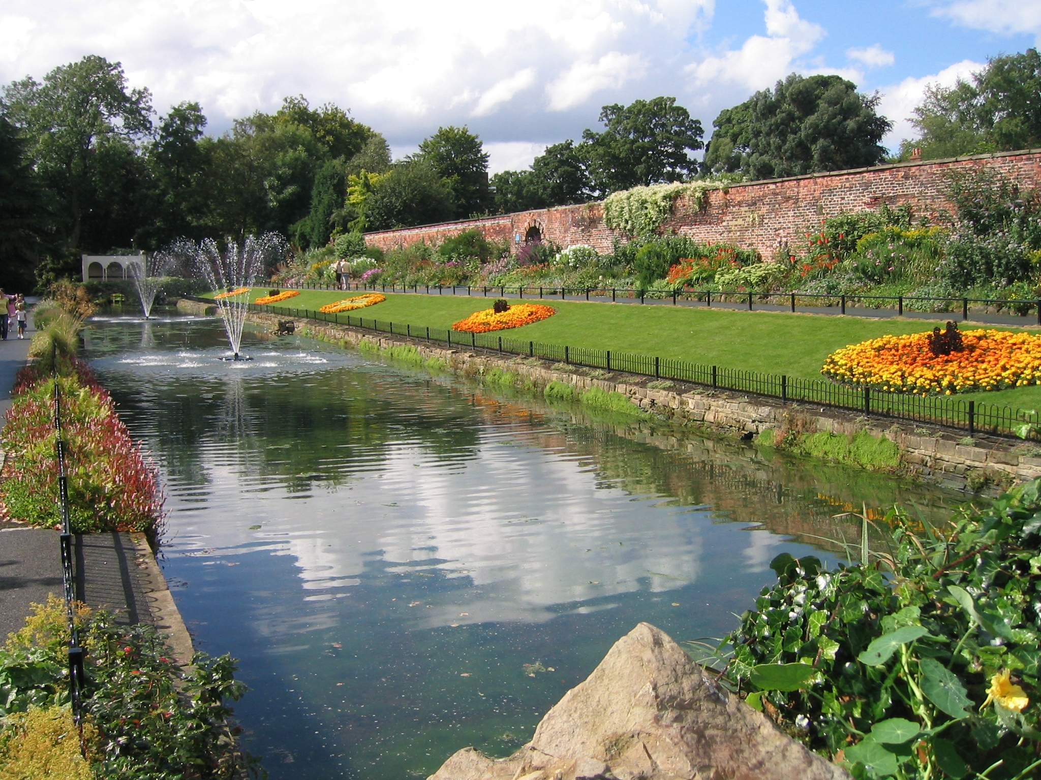
Waterloo Lake, located in Yorkshire, is a picturesque freshwater body encompassing an area of approximately 5 acres. This natural beauty spot is often referred to as a lake, although its size might also classify it as a pool or a pond. The lake is situated within a larger nature reserve, surrounded by lush greenery and diverse wildlife, making it a popular destination for both locals and tourists.

The tranquil waters of Waterloo Lake are home to a variety of freshwater species, including fish, frogs, and waterfowl. These creatures thrive in the lake's clean and well-maintained environment, providing a visually pleasing spectacle for visitors. The lake also acts as a freshwater marsh, with patches of reeds and grasses growing along its edges, further enhancing its natural charm.

At Waterloo Lake, visitors can enjoy a range of recreational activities. Fishing is a popular pastime, with anglers often seen casting their lines from the lake's banks. The lake is stocked with a variety of fish species, including carp, roach, and perch, providing ample opportunities for a successful catch.

For those seeking a leisurely stroll, a well-maintained path surrounds the lake, offering a scenic route for walkers and joggers. The path is also wheelchair accessible, making the lake an inclusive destination for all.

With its serene atmosphere and abundant wildlife, Waterloo Lake in Yorkshire provides a serene escape from the hustle and bustle of everyday life. Whether it's fishing, wildlife spotting, or simply enjoying a peaceful walk, this freshwater gem offers something for everyone to appreciate and enjoy.

If you have any feedback on the listing, please let us know in the comments section below.

Waterloo Lake Images

Images are sourced within 2km of 53.833399/-1.4933284 or Grid Reference SE3337. Thanks to Geograph Open Source API. All images are credited.

Roundhay, St Edmund's church This benchmark is cut into the west facing wall of the church on Lidgett Park Road. It is on the 2nd course of stone.
Roundhay, St Edmund's church
This benchmark is cut into the west facing wall of the church on Lidgett Park Road. It is on the 2nd course of stone.
Roundhay, St Edmund's church This is the west facing wall of St Edmund's church on Lidgett Park Road. There is a benchmark cut into the 2nd course of stone, and the 4th stone to the left of the corner.
Roundhay, St Edmund's church
This is the west facing wall of St Edmund's church on Lidgett Park Road. There is a benchmark cut into the 2nd course of stone, and the 4th stone to the left of the corner.
Lidgett Lane and Lidgett Avenue junction This stone post is on the east side of Lidgett Lane, and at the junction with Lidgett Avenue. The stone faces west and the benchmark is cut about 1 foot from ground level.
Lidgett Lane and Lidgett Avenue junction
This stone post is on the east side of Lidgett Lane, and at the junction with Lidgett Avenue. The stone faces west and the benchmark is cut about 1 foot from ground level.
Lidgett Lane and Lidgett Avenue junction This stone post is on the east side of Lidgett Lane, and at the junction with Lidgett Avenue. The stone faces west and there is a benchmark cut about 1 foot from ground level.
Lidgett Lane and Lidgett Avenue junction
This stone post is on the east side of Lidgett Lane, and at the junction with Lidgett Avenue. The stone faces west and there is a benchmark cut about 1 foot from ground level.
Rounday, Talbot Road This is the north facing wall of 27 Talbot Road, and there is a benchmark cut into the 4th and 5th brick course.
Rounday, Talbot Road
This is the north facing wall of 27 Talbot Road, and there is a benchmark cut into the 4th and 5th brick course.
Roundhay, East Moor Road This is the north facing wall of the school house which sits within the grounds of a primary school on East Moor Road. Cut into the 6th and 7th brick courses is a benchmark.
Roundhay, East Moor Road
This is the north facing wall of the school house which sits within the grounds of a primary school on East Moor Road. Cut into the 6th and 7th brick courses is a benchmark.
Roundhay, Talbot Road This roadside wall is on the west side of Talbot Road, and just north of the junction with Talbot Avenue. There is a benchmark cut into the base stone of the block wall.
Roundhay, Talbot Road
This roadside wall is on the west side of Talbot Road, and just north of the junction with Talbot Avenue. There is a benchmark cut into the base stone of the block wall.
Roundhay, Talbot Road The road off to the right is Talbot Avenue, and this is the T junction with Talbot Road. The roadside wall is on the west side of Talbot Road, and there is a benchmark cut into the base stone of the block wall.
Roundhay, Talbot Road
The road off to the right is Talbot Avenue, and this is the T junction with Talbot Road. The roadside wall is on the west side of Talbot Road, and there is a benchmark cut into the base stone of the block wall.
Roundhay, Talbot Road This is the south facing wall of 88 Talbot Road in Roundhay. There is a benchmark cut into the 6th and 7th brick courses, to the left of the airbrick.
Roundhay, Talbot Road
This is the south facing wall of 88 Talbot Road in Roundhay. There is a benchmark cut into the 6th and 7th brick courses, to the left of the airbrick.
Roundhay, North Park Avenue This stone building is the Methodist church on south side of North Park Avenue. This is a north-east facing wall, and cut into the 3rd stone course is a very clear benchmark.
Roundhay, North Park Avenue
This stone building is the Methodist church on south side of North Park Avenue. This is a north-east facing wall, and cut into the 3rd stone course is a very clear benchmark.
Roundhay, North Park Avenue This is the Methodist church on the south side of North Park Avenue. On the north-east facing wall, and cut into the 3rd stone course is a very clear benchmark.
Roundhay, North Park Avenue
This is the Methodist church on the south side of North Park Avenue. On the north-east facing wall, and cut into the 3rd stone course is a very clear benchmark.
The Lake, Gledhow Valley Woods, Leeds This was part of the landscaping of the Gledhow Hall parkland, but was altered in the 1950s to provide flood attenuation, hence the elaborate outlet weir and screens.  The bay and screen in this image puzzles me - is it an inlet or an outlet?
The Lake, Gledhow Valley Woods, Leeds
This was part of the landscaping of the Gledhow Hall parkland, but was altered in the 1950s to provide flood attenuation, hence the elaborate outlet weir and screens. The bay and screen in this image puzzles me - is it an inlet or an outlet?
"I'm not dead yet", Gledhow Valley Woods Oak leaves sprouting from a tree stump.
"I'm not dead yet", Gledhow Valley Woods
Oak leaves sprouting from a tree stump.
Path at the top of the valley slope, Gledhow Valley Woods, Leeds
Heritage Open Day at Gipton Spa Bath House, Leeds This was organised by the Friends of Gledhow Valley Woods. Refreshments were available and various items were on sale.
Heritage Open Day at Gipton Spa Bath House, Leeds
This was organised by the Friends of Gledhow Valley Woods. Refreshments were available and various items were on sale.
Entrance to Gipton Spa Bath House, Leeds The entrance is into a small room with a fireplace and a basin with spring water. There is a doorway into the bath, to the right. The bath is fed by a spring, and has moss on the bottom. An inscription gives the date 1671 for the building.
Entrance to Gipton Spa Bath House, Leeds
The entrance is into a small room with a fireplace and a basin with spring water. There is a doorway into the bath, to the right. The bath is fed by a spring, and has moss on the bottom. An inscription gives the date 1671 for the building.
Inscription in Gipton Spa Bath House, Leeds According to the listing details the inscription is: Hoc faecit Edwardus Waddington de Gleadhowe Annovae Domini 1671.
Inscription in Gipton Spa Bath House, Leeds
According to the listing details the inscription is: Hoc faecit Edwardus Waddington de Gleadhowe Annovae Domini 1671.
Sheep in a field alongside the ring road Despite the rural scene this is in fact taken from the cycle track alongside the busy Leeds ring road.
Sheep in a field alongside the ring road
Despite the rural scene this is in fact taken from the cycle track alongside the busy Leeds ring road.
Show me another place!

Waterloo Lake is located at Grid Ref: SE3337 (Lat: 53.833399, Lng: -1.4933284)

Division: West Riding

Unitary Authority: Leeds

Police Authority: West Yorkshire

What 3 Words

///green.areas.split. Near Shadwell, West Yorkshire

Related Wikis

Roundhay

Roundhay is a large suburb in north-east Leeds, West Yorkshire, England. Roundhay had a population of 22,546 in 2011.It sits in the Roundhay ward of Leeds...

Roundhay Garden Scene

Roundhay Garden Scene is a short silent motion picture filmed by French inventor Louis Le Prince at Oakwood Grange in Roundhay, Leeds, in Northern England...
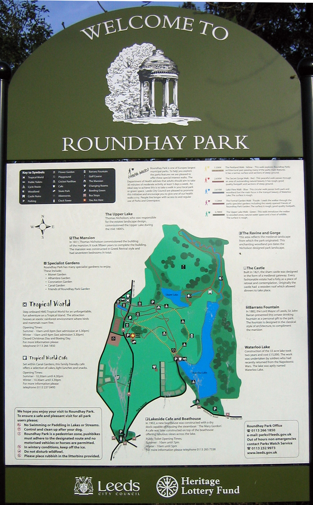
Roundhay Park

Roundhay Park in Leeds, West Yorkshire, England, is one of the biggest city parks in Europe. It covers more than 700 acres (2.8 km2) of parkland, lakes...

Oakwood, Leeds

Oakwood is a suburb of north-east Leeds, West Yorkshire, England, that lies between Gipton and Roundhay Park. The suburb lies within the LS8 postcode and...

Nearby Amenities

Located within 500m of 53.833399,-1.4933284
Bus Stop
Wetherby Road Elmete Avenue
Bus: yes
Local Ref: 45010239
Naptan AtcoCode: 450010239
Naptan Bearing: NW
Naptan CommonName: Wetherby Road Elmete Avenue
Naptan Crossing: Elmete Avenue
Naptan Indicator: Stop 45010239
Naptan Landmark: Braim Wood Boys High School
Naptan PlusbusZoneRef: LEEDS
Naptan ShortCommonName: Elmete Avenue
Naptan Street: Wetherby Road
Naptan Verified: no
Public Transport: platform
Source: naptan_import
Lat/Long: 53.8301484/-1.4933292
Bus Stop
Wetherby Road Elmete Avenue
Bus: yes
Local Ref: 45013909
Naptan AtcoCode: 450013909
Naptan Bearing: E
Naptan CommonName: Wetherby Road Elmete Avenue
Naptan Crossing: Elmete Avenue
Naptan Indicator: Stop 45013909
Naptan Landmark: Rear Roundhay Park Gates
Naptan PlusbusZoneRef: LEEDS
Naptan ShortCommonName: Elmete Avenue
Naptan Street: Wetherby Road
Naptan Verified: no
Public Transport: platform
Source: naptan_import
Lat/Long: 53.830493/-1.4940392
Bus Stop
Wetherby Road Roundhay
Bus: yes
Local Ref: 45013910
Naptan AtcoCode: 450013910
Naptan Bearing: E
Naptan CommonName: Wetherby Road Roundhay
Naptan Crossing: Elmete Drive
Naptan Indicator: Stop 45013910
Naptan Landmark: Unknown
Naptan PlusbusZoneRef: LEEDS
Naptan ShortCommonName: Elmete Drive
Naptan Street: Wetherby Road
Naptan Verified: no
Public Transport: platform
Source: naptan_import
Lat/Long: 53.8296108/-1.4894765
Bus Stop
Wetherby Road Elmete Drive
Bus: yes
Local Ref: 45013914
Naptan AtcoCode: 450013914
Naptan Bearing: W
Naptan CommonName: Wetherby Road Elmete Drive
Naptan Crossing: Elmete Drive
Naptan Indicator: Stop 45013914
Naptan Landmark: Montesorri School
Naptan PlusbusZoneRef: LEEDS
Naptan ShortCommonName: Elmete Drive
Naptan Street: Wetherby Road
Naptan Verified: no
Public Transport: platform
Source: naptan_import
Lat/Long: 53.8295597/-1.4901456
West Court
Addr Street: West Avenue
Building: yes
Lat/Long: 53.8336983/-1.4985857
Golf: tee
Ref: 1
Surface: grass
Tee: white
Lat/Long: 53.8356465/-1.4881635
Golf: pin
Ref: 18
Tee: white
Lat/Long: 53.8358304/-1.4883746
Golf: tee
Tee: red
Lat/Long: 53.8359918/-1.490142
Golf: tee
Tee: yellow
Lat/Long: 53.8359963/-1.4904179
Golf: tee
Ref: 18
Surface: grass
Tee: white
Lat/Long: 53.8360138/-1.4906836
Golf: pin
Ref: 17
Lat/Long: 53.8362249/-1.4904709
Noexit: yes
Lat/Long: 53.8307374/-1.4983063
Traffic Calming: bump
Lat/Long: 53.8296521/-1.4909118
Pub
White House
Addr City: Leeds
Addr Housenumber: 55
Addr Postcode: LS8 2JU
Addr Street: Wetherby Road
Addr Suburb: Roundhay
Brand: Chef & Brewer
Brand Wikidata: Q5089491
Fhrs Id: 928940
Name En: White House
Website: https://www.chefandbrewer.com/pubs/west-yorkshire/white-house
Wikidata: Q61890135
Lat/Long: 53.8305985/-1.4969092
Kindergarten
Leeds Montessori Pre-School And Nursery
Addr City: Leeds
Addr Postcode: LS8 2LE
Addr Street: Wetherby Road
Addr Suburb: Roundhay
Fhrs Id: 322630
Lat/Long: 53.8297423/-1.489192
Shelter
Bench: yes
Bin: yes
Lat/Long: 53.8369931/-1.4949972
Braim Wood
Natural: wood
Lat/Long: 53.837216/-1.4909884
Barrier: bollard
Lat/Long: 53.8306102/-1.4942432
Barrier: bollard
Lat/Long: 53.8306174/-1.4942648
Barrier: bollard
Lat/Long: 53.8305965/-1.4942024
Barrier: bollard
Lat/Long: 53.8354884/-1.49714
Barrier: bollard
Lat/Long: 53.8354812/-1.4971073
Barrier: bollard
Lat/Long: 53.8354729/-1.4970781
Barrier: bollard
Lat/Long: 53.8354636/-1.4970472
Barrier: bollard
Lat/Long: 53.8353788/-1.4970023
Barrier: bollard
Lat/Long: 53.8353592/-1.4970126
Barrier: bollard
Lat/Long: 53.8353408/-1.4970215
Barrier: bollard
Lat/Long: 53.8353206/-1.497028
Barrier: bollard
Lat/Long: 53.8352436/-1.4970616
Barrier: bollard
Lat/Long: 53.8352639/-1.4970551
Barrier: bollard
Lat/Long: 53.8352823/-1.4970462
Barrier: bollard
Lat/Long: 53.8353018/-1.4970359
Barrier: bollard
Lat/Long: 53.8351657/-1.4970814
Barrier: bollard
Lat/Long: 53.8351863/-1.4970786
Barrier: bollard
Lat/Long: 53.8352051/-1.4970732
Barrier: bollard
Lat/Long: 53.8352252/-1.4970665
Barrier: bollard
Lat/Long: 53.8354572/-1.4970198
Barrier: bollard
Lat/Long: 53.8354439/-1.4970037
Barrier: bollard
Lat/Long: 53.8354283/-1.4969973
Barrier: bollard
Lat/Long: 53.8353984/-1.4969987
Barrier: bollard
Lat/Long: 53.8354133/-1.496998
Barrier: bollard
Lat/Long: 53.8350447/-1.4971045
Barrier: bollard
Lat/Long: 53.8350653/-1.4971034
Barrier: bollard
Lat/Long: 53.8350843/-1.4970996
Barrier: bollard
Lat/Long: 53.8351045/-1.4970947
Barrier: bollard
Lat/Long: 53.8351231/-1.4970914
Barrier: bollard
Lat/Long: 53.8351435/-1.4970867
Barrier: bollard
Lat/Long: 53.8349617/-1.4971089
Barrier: bollard
Lat/Long: 53.8349823/-1.4971102
Barrier: bollard
Lat/Long: 53.8350014/-1.4971086
Barrier: bollard
Lat/Long: 53.8350218/-1.497106
Barrier: bollard
Lat/Long: 53.8348777/-1.497101
Barrier: bollard
Lat/Long: 53.8348982/-1.4971051
Barrier: bollard
Lat/Long: 53.8349173/-1.497106
Barrier: bollard
Lat/Long: 53.8349378/-1.4971061
Barrier: bollard
Lat/Long: 53.8347957/-1.4970955
Barrier: bollard
Lat/Long: 53.8348162/-1.4970998
Barrier: bollard
Lat/Long: 53.8348353/-1.4971008
Barrier: bollard
Lat/Long: 53.8348558/-1.4971012
Barrier: bollard
Lat/Long: 53.834754/-1.4970877
Barrier: bollard
Lat/Long: 53.8347745/-1.497092
Barrier: bollard
Lat/Long: 53.8346536/-1.497059
Barrier: bollard
Lat/Long: 53.834674/-1.4970646
Barrier: bollard
Lat/Long: 53.8346952/-1.4970695
Barrier: bollard
Lat/Long: 53.8347155/-1.497075
Barrier: bollard
Lat/Long: 53.8347361/-1.4970799
Barrier: bollard
Lat/Long: 53.8345564/-1.4970181
Barrier: bollard
Lat/Long: 53.8345765/-1.4970261
Barrier: bollard
Lat/Long: 53.8345974/-1.4970334
Barrier: bollard
Lat/Long: 53.8346175/-1.4970414
Barrier: bollard
Lat/Long: 53.8346364/-1.497051
Barrier: bollard
Lat/Long: 53.8345391/-1.4970119
Barrier: bollard
Lat/Long: 53.834525/-1.4970097
Barrier: bollard
Lat/Long: 53.8345099/-1.4970078
Traffic Calming: bump
Lat/Long: 53.8295976/-1.4898799
Getech Group
Addr City: Leeds
Addr Housename: Kitson House
Addr Postcode: LS8 2LJ
Office: company
Opening Hours: Mo-Fr 09:00-17:00
Lat/Long: 53.8341225/-1.4866638
Waste Basket
Collection Times: Mo-Fr
Ref UK Leedscc Bin: 3547
Lat/Long: 53.835416/-1.497479
Waste Basket
Collection Times: Mo-Fr
Ref UK Leedscc Bin: 3549
Lat/Long: 53.834881/-1.497183
Waste Basket
Collection Times: Mo-Fr
Ref UK Leedscc Bin: 3548
Lat/Long: 53.834013/-1.496736
Waste Basket
Collection Times: We; Su
Ref UK Leedscc Bin: 3598
Lat/Long: 53.830032/-1.497671
Waste Basket
Collection Times: We; Su
Ref UK Leedscc Bin: 3597
Lat/Long: 53.829871/-1.491912
Bench
Backrest: no
Lat/Long: 53.8351426/-1.4912988
Bench
Backrest: no
Lat/Long: 53.836592/-1.4915609
Bench
Backrest: no
Lat/Long: 53.8370804/-1.4918267
Bench
Backrest: no
Lat/Long: 53.8370123/-1.4931766
Bench
Backrest: no
Lat/Long: 53.8328034/-1.4909632
Bench
Backrest: no
Lat/Long: 53.8318492/-1.4910485
Bench
Backrest: yes
Lat/Long: 53.8311921/-1.493801
Bench
Backrest: no
Lat/Long: 53.8342327/-1.4919762
Bicycle Parking
Access: yes
Bicycle Parking: stands
Capacity: 10
Fee: no
Lat/Long: 53.8299703/-1.4909733
The data included in this document is from www.openstreetmap.org. The data is made available under ODbL.

Have you been to Waterloo Lake?

Leave your review of Waterloo Lake below (or comments, questions and feedback).