Great Longstone

Settlement in Derbyshire Derbyshire Dales

England

Great Longstone

Longstone Moor Remains of old lead workings around Watershaw Rake on Longstone Moor
Longstone Moor Credit: Alan Fleming

Great Longstone is a small village located in the Peak District National Park in Derbyshire, England. Situated about 4 miles east of Bakewell, the village is surrounded by picturesque countryside and offers stunning views of the surrounding hills and dales.

The village itself is characterized by its charming stone cottages, narrow lanes, and a historic parish church dedicated to St. Giles. There is also a village green, a primary school, a pub, and a village hall which serves as a hub for community events and activities.

Great Longstone is a popular destination for hikers and outdoor enthusiasts, with numerous walking trails and footpaths leading through the surrounding countryside. The village is also conveniently located near popular attractions such as Chatsworth House, Haddon Hall, and the Monsal Trail.

Overall, Great Longstone is a tranquil and idyllic village that offers a peaceful retreat for those looking to escape the hustle and bustle of urban life and immerse themselves in the natural beauty of the Peak District.

If you have any feedback on the listing, please let us know in the comments section below.

Great Longstone Images

Images are sourced within 2km of 53.241903/-1.698597 or Grid Reference SK2071. Thanks to Geograph Open Source API. All images are credited.

Longstone Moor Remains of old lead workings around Watershaw Rake on Longstone Moor
Longstone Moor
Remains of old lead workings around Watershaw Rake on Longstone Moor
Walking group on Longstone Moor, NW of Great Longstone
Isolated pine trees Longstone Moor
Moorland at south side of Longstone Moor A public footpath can be seen passing through the heather crossing the moor from north to south. Mining has taken place on the ground here and some disturbance can be seen in the foreground which must be on the line of the Watersaw Rake.
Moorland at south side of Longstone Moor
A public footpath can be seen passing through the heather crossing the moor from north to south. Mining has taken place on the ground here and some disturbance can be seen in the foreground which must be on the line of the Watersaw Rake.
Path on Longstone moor. A lovely upland area with lots of paths and tracks.
Path on Longstone moor.
A lovely upland area with lots of paths and tracks.
Watersaw Rake Hiking with The Witch and friends.
Watersaw Rake
Hiking with The Witch and friends.
Peak and Northern Footpath Society Wayfinding Sign on Longstone Moor, Derbyshire An elaborate metal sign plate typical of the style used by the Peak and Northern Footpath Society.
Peak and Northern Footpath Society Wayfinding Sign on Longstone Moor, Derbyshire
An elaborate metal sign plate typical of the style used by the Peak and Northern Footpath Society.
Two trees at Watersaw Rake - Longstone Moor
Tree on Longstone Moor
A pair of battered trees on Longstone Moor
Sheep at Watersaw Rake, Longstone Moor
Path on Longstone Moor As is often the case on access land, the paths on the ground do not always correspond with the paths marked on the OS map.
Path on Longstone Moor
As is often the case on access land, the paths on the ground do not always correspond with the paths marked on the OS map.
Path through the heather on Longstone Moor
Heather in Flower on Longstone Moor Footpath on Longstone Moor, pictured here on a fine Sunday in mid August - the best time to see the heather in full bloom.
Heather in Flower on Longstone Moor
Footpath on Longstone Moor, pictured here on a fine Sunday in mid August - the best time to see the heather in full bloom.
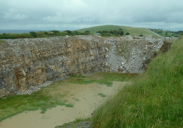
Old quarry by Longstone Edge There have been extensive workings for limestone and fluorspar, as well as lead, in the area.
Old quarry by Longstone Edge
There have been extensive workings for limestone and fluorspar, as well as lead, in the area.
View fromWatersaw Rake A clear track across moorland, much quarried for lead.in previous times.End of winter and the grasses are awaiting new growth. A small group of trees on the horizon.
View fromWatersaw Rake
A clear track across moorland, much quarried for lead.in previous times.End of winter and the grasses are awaiting new growth. A small group of trees on the horizon.
Pine trees and cairn On a path on the high ground north of Great Longstone, looking south.
Pine trees and cairn
On a path on the high ground north of Great Longstone, looking south.
Moorland track  north of Great Longstone Gnarled thorn and pile of stones, remnant of a wall.
Moorland track north of Great Longstone
Gnarled thorn and pile of stones, remnant of a wall.
Show me another place!

Great Longstone is located at Grid Ref: SK2071 (Lat: 53.241903, Lng: -1.698597)

Administrative County: Derbyshire

District: Derbyshire Dales

Police Authority: Derbyshire

What 3 Words

///trying.prefer.waltz. Near Bakewell, Derbyshire

Related Wikis

Great Longstone

Great Longstone with Little Longstone is one of two villages in the local government district of Derbyshire Dales in Derbyshire, England. The population...

St Giles' Church, Longstone

St Giles’ Church, Longstone (also known as St Giles' Church, Great Longstone) is a Grade I listed parish church in the Church of England in Great Longstone...

Great Longstone War Memorial

Great Longstone War Memorial is a 20th-century grade II listed war memorial in Great Longstone, Derbyshire. == History == The war memorial was unveiled...

Great Longstone for Ashford railway station

Great Longstone for Ashford railway station was a station which served Great and Little Longstone in the Peak District of Derbyshire. It was opened in...

Nearby Amenities

Located within 500m of 53.241903,-1.698597
Great Longstone
Is In: Derbyshire, England, UK
Place: village
Wikidata: Q3155262
Wikipedia: en:Great Longstone
Lat/Long: 53.2433688/-1.7029349
Post Box
Operator: Royal Mail
Ref: DE45 1292
Lat/Long: 53.2420389/-1.6983638
Post Box
Collection Times: Mo-Fr 09:00; Sa 07:00
Note: Moved to its correct position south of the road
Operator: Royal Mail
Post Box Type: pillar
Ref: DE45 1283
Royal Cypher: GVIR
Lat/Long: 53.2426743/-1.702258
Pub
Crispin
Addr City: Bakewell
Addr Postcode: DE45 1TZ
Addr Street: Main Street
Addr Village: Great Longstone
Fhrs Id: 1626304
Wikidata: Q26597976
Lat/Long: 53.2430476/-1.7040155
Bench
Backrest: yes
Ele: 183.9765625
Lat/Long: 53.2427417/-1.7024874
Barrier: stile
Material: stone
Stile: squeezer
Lat/Long: 53.2448948/-1.698929
Defibrillator
Access: yes
Booth: K6
Check Date: 2024-01-11
Covered: booth
Defibrillator Location: inside old red phone box, by village green, Great Longstone
Ele: 186.1395264
Emergency: defibrillator
Indoor: no
Listed Status: Grade II
Man Made: telephone_box
Not Ref GB The Circuit: 71B6FDC5-023D-4C5F-805E-B0CB00FBCB61
Lat/Long: 53.2430673/-1.7031075
Bus Stop
Great Longstone (Village Green)
Bench: yes
Bin: yes
Bus: yes
Ele: 187.1008301
Lit: no
Naptan AtcoCode: 1000DGLM3674
Naptan NaptanCode: dbsgamdg
Public Transport: platform
Shelter: yes
Tactile Paving: no
Lat/Long: 53.2430996/-1.703328
Bench
Lat/Long: 53.2431517/-1.7024729
Barrier: kissing_gate
Ele: 195.99
Lat/Long: 53.2434837/-1.7017658
Ele: 194.7913818
Lat/Long: 53.2433603/-1.7019995
Barrier: kissing_gate
Ele: 191.4267578
Lat/Long: 53.2431032/-1.7025842
Ele: 191.9074707
Lat/Long: 53.2430761/-1.7026578
Barrier: stile
Stile: squeezer
Lat/Long: 53.2440496/-1.700829
Barrier: stile
Material: stone
Stile: squeezer
Lat/Long: 53.2457754/-1.6955275
Barrier: stile
Material: stone
Source: survey
Stile: squeezer
Lat/Long: 53.2452555/-1.6974206
Barrier: stile
Material: stone
Source: survey;gps
Stile: squeezer
Lat/Long: 53.2446044/-1.6993103
Barrier: stile
Stile: squeezer
Lat/Long: 53.2460352/-1.6999103
Barrier: stile
Source: survey;bing;gps
Stile: squeezer
Lat/Long: 53.2418907/-1.7019565
Barrier: stile
Material: stone
Source: survey;bing;gps
Stile: squeezer
Lat/Long: 53.2414089/-1.704359
Barrier: stile
Material: stone
Source: survey;bing;gps
Stile: squeezer
Lat/Long: 53.2413804/-1.7034838
Barrier: stile
Material: stone
Source: survey;bing;gps
Stile: squeezer
Lat/Long: 53.2414632/-1.7019256
Tourism: picnic_site
Lat/Long: 53.2415351/-1.7020264
Barrier: stile
Material: stone
Stile: squeezer
Lat/Long: 53.2386171/-1.6951319
Barrier: stile
Stile: squeezer
Lat/Long: 53.2398531/-1.6966703
Bench
Lat/Long: 53.2413293/-1.6987204
Bench
Lat/Long: 53.2412073/-1.6993414
Leaside Cottage
Addr City: Bakewell
Addr Housename: Leaside Cottage
Addr Postcode: DE45 1TS
Addr Street: Station Road
Lat/Long: 53.2427877/-1.7039787
War Memorial
Historic: memorial
Memorial: war_memorial
Lat/Long: 53.2428487/-1.703039
Village Cross
Historic: memorial
Lat/Long: 53.2429691/-1.7034229
Barrier: stile
Stile: squeezer
Lat/Long: 53.2444304/-1.6977221
Barrier: stile
Material: stone
Source: survey;gps
Stile: squeezer
Lat/Long: 53.2460676/-1.6972886
Barrier: kissing_gate
Source: survey;gps
Lat/Long: 53.2382591/-1.6988115
Barrier: stile
Material: stone
Source: survey;gps
Stile: stepover
Lat/Long: 53.2383452/-1.702009
Barrier: kissing_gate
Source: survey;gps
Lat/Long: 53.2387167/-1.699595
Barrier: stile
Material: stone
Source: survey;gps
Stile: squeezer
Lat/Long: 53.2391314/-1.7014268
Bench
Backrest: yes
Source: survey;gps
Lat/Long: 53.2430015/-1.7032998
Great Longstone (Village Green)
Bus: yes
Public Transport: stop_position
Lat/Long: 53.2430886/-1.703416
Bus Stop
Great Longstone (Village Green)
Bench: yes
Bin: no
Bus: yes
Lit: yes
Naptan AtcoCode: 1000DGLM3673
Naptan NaptanCode: dbsgamda
Public Transport: platform
Shelter: no
Tactile Paving: no
Lat/Long: 53.2430601/-1.7034354
Barrier: stile
Material: stone
Source: survey;gps
Stile: squeezer
Lat/Long: 53.2390003/-1.703058
Sunnylea Cottage
Addr City: Bakewell
Addr Housename: Sunnylea Cottage
Addr Postcode: DE45 1TS
Addr Street: Station Road
Addr Village: Great Longstone
Lat/Long: 53.2427453/-1.7040823
Turning Circle
Lat/Long: 53.2440935/-1.7039892
Great Longstone (Village Green)
Bus: yes
Public Transport: stop_position
Lat/Long: 53.2430694/-1.703358
Bus Stop
Great Longstone (Croft Road)
Bus: yes
Public Transport: platform
Lat/Long: 53.2418793/-1.698836
Great Longstone (Croft Road)
Bus: yes
Public Transport: stop_position
Lat/Long: 53.2419114/-1.6988374
Barrier: yes
Foot: yes
Lat/Long: 53.2400747/-1.6997638
Generator Method: photovoltaic
Generator Output Electricity: yes
Generator Source: solar
Generator Type: solar_photovoltaic_panel
Location: roof
Power: generator
Lat/Long: 53.2410628/-1.695735
Generator Method: photovoltaic
Generator Output Electricity: yes
Generator Source: solar
Generator Type: solar_photovoltaic_panel
Location: roof
Power: generator
Lat/Long: 53.2410957/-1.6956585
Generator Method: photovoltaic
Generator Output Electricity: yes
Generator Source: solar
Generator Type: solar_photovoltaic_panel
Location: roof
Power: generator
Lat/Long: 53.2401406/-1.6972934
Generator Method: photovoltaic
Generator Output Electricity: yes
Generator Source: solar
Generator Type: solar_photovoltaic_panel
Location: roof
Power: generator
Lat/Long: 53.2400524/-1.6982683
Generator Method: photovoltaic
Generator Output Electricity: yes
Generator Source: solar
Generator Type: solar_photovoltaic_panel
Location: roof
Power: generator
Lat/Long: 53.2400018/-1.6991266
Generator Method: photovoltaic
Generator Output Electricity: yes
Generator Source: solar
Generator Type: solar_photovoltaic_panel
Location: roof
Power: generator
Lat/Long: 53.2402778/-1.7027389
Generator Method: photovoltaic
Generator Output Electricity: yes
Generator Source: solar
Generator Type: solar_photovoltaic_panel
Location: roof
Power: generator
Lat/Long: 53.2424721/-1.7034106
Generator Method: photovoltaic
Generator Output Electricity: yes
Generator Source: solar
Generator Type: solar_photovoltaic_panel
Location: roof
Power: generator
Lat/Long: 53.2424617/-1.7034535
Generator Method: photovoltaic
Generator Output Electricity: yes
Generator Source: solar
Generator Type: solar_photovoltaic_panel
Location: roof
Power: generator
Lat/Long: 53.240692/-1.6924484
Generator Method: photovoltaic
Generator Output Electricity: yes
Generator Source: solar
Generator Type: solar_photovoltaic_panel
Location: roof
Power: generator
Lat/Long: 53.2417578/-1.6995683
Generator Method: photovoltaic
Generator Output Electricity: yes
Generator Source: solar
Generator Type: solar_photovoltaic_panel
Location: roof
Power: generator
Lat/Long: 53.2421358/-1.7032577
Barrier: stile
Material: stone
Source: survey;gps
Stile: squeezer
Lat/Long: 53.2413995/-1.7033321
Historic: pump
Lat/Long: 53.2428167/-1.7011674
Watering Place
Lat/Long: 53.2431056/-1.7011089
The data included in this document is from www.openstreetmap.org. The data is made available under ODbL.

Have you been to Great Longstone?

Leave your review of Great Longstone below (or comments, questions and feedback).