Basin Pond

Lake, Pool, Pond, Freshwater Marsh in Oxfordshire West Oxfordshire

England

Basin Pond

A361 Looking south along the A361 on Shipton Down.
A361 Credit: Ian Capper

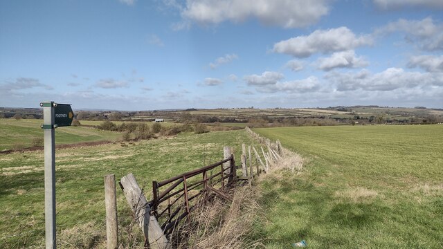
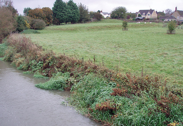
Basin Pond is a picturesque freshwater pond located in Oxfordshire, England. Nestled amidst the serene countryside, it is a popular destination for nature enthusiasts and locals alike. Spread across an area of approximately 2 acres, Basin Pond is a tranquil haven that offers a diverse range of flora and fauna.

The pond is encompassed by lush greenery, with dense vegetation lining its banks. Tall reeds and water lilies adorn the water's surface, adding to the pond's natural beauty. The calm and crystal-clear waters of Basin Pond create a serene atmosphere that is perfect for relaxation and contemplation.

The pond is home to a variety of wildlife, making it a haven for nature lovers and birdwatchers. Visitors can observe numerous species of birds, including ducks, swans, and herons, gliding gracefully across the water. Additionally, the pond is inhabited by various fish species, such as carp and perch, which can be seen swimming beneath the surface.

Surrounding the pond, there are several walking trails that offer stunning views and opportunities for exploration. Visitors can take leisurely strolls along the shoreline, immersing themselves in the tranquility of the surroundings. The pond also serves as a popular spot for fishing, offering anglers a chance to try their luck in catching some of the local fish species.

Overall, Basin Pond is a delightful natural gem in Oxfordshire, offering a peaceful and idyllic setting for visitors to enjoy the beauty of nature. Whether it be birdwatching, fishing, or simply seeking solace in the midst of serene surroundings, Basin Pond is a must-visit destination for those seeking a connection with the great outdoors.

If you have any feedback on the listing, please let us know in the comments section below.

Basin Pond Images

Images are sourced within 2km of 51.854832/-1.6045516 or Grid Reference SP2717. Thanks to Geograph Open Source API. All images are credited.

A361 Looking south along the A361 on Shipton Down.
A361
Looking south along the A361 on Shipton Down.
Shipton Down A field alongside the A361 on Shipton Down.
Shipton Down
A field alongside the A361 on Shipton Down.
Shipton Down A field alongside the A361 on Shipton Down.
Shipton Down
A field alongside the A361 on Shipton Down.
St Simon & St Jude, Milton-under-Wychwood
Path to Leafield Road Off the B4437 the path to Leafield Road
Path to Leafield Road
Off the B4437 the path to Leafield Road
Stone stile, Milton-under-Wychwood On the LHS of the Lychgate looking to the St Simon and St Jude churchyard. 
The view from the churchyard is <a href="https://www.geograph.org.uk/photo/7491816">SP2618 : Stone stile, Milton-under-Wychwood</a>.
The view of both is <a href="https://www.geograph.org.uk/photo/7491828">SP2618 : Stone Stiles, Milton-under-Wychwood</a>.
Stone stile, Milton-under-Wychwood
On the LHS of the Lychgate looking to the St Simon and St Jude churchyard. The view from the churchyard is SP2618 : Stone stile, Milton-under-Wychwood. The view of both is SP2618 : Stone Stiles, Milton-under-Wychwood.
Stone stile, Milton-under-Wychwood On the LHS of the Lychgate looking from the St Simon and St Jude churchyard. 
The view from Church Road is <a href="https://www.geograph.org.uk/photo/7491815">SP2618 : Stone stile, Milton-under-Wychwood</a>.
The view of both is <a href="https://www.geograph.org.uk/photo/7491828">SP2618 : Stone Stiles, Milton-under-Wychwood</a>.
Stone stile, Milton-under-Wychwood
On the LHS of the Lychgate looking from the St Simon and St Jude churchyard. The view from Church Road is SP2618 : Stone stile, Milton-under-Wychwood. The view of both is SP2618 : Stone Stiles, Milton-under-Wychwood.
Stone stile, Milton-under-Wychwood On the RHS of the Lychgate looking to the St Simon and St Jude churchyard. 
The view from the churchyard is <a href="https://www.geograph.org.uk/photo/7491827">SP2618 : Stone stile, Milton-under-Wychwood</a>.
The view of both is <a href="https://www.geograph.org.uk/photo/7491828">SP2618 : Stone Stiles, Milton-under-Wychwood</a>.
Stone stile, Milton-under-Wychwood
On the RHS of the Lychgate looking to the St Simon and St Jude churchyard. The view from the churchyard is SP2618 : Stone stile, Milton-under-Wychwood. The view of both is SP2618 : Stone Stiles, Milton-under-Wychwood.
Stone stile, Milton-under-Wychwood On the RHS of the Lychgate looking from the St Simon and St Jude churchyard. 
The view from Church Road is <a href="https://www.geograph.org.uk/photo/7491826">SP2618 : Stone stile, Milton-under-Wychwood</a>.
The view of both is <a href="https://www.geograph.org.uk/photo/7491828">SP2618 : Stone Stiles, Milton-under-Wychwood</a>.
Stone stile, Milton-under-Wychwood
On the RHS of the Lychgate looking from the St Simon and St Jude churchyard. The view from Church Road is SP2618 : Stone stile, Milton-under-Wychwood. The view of both is SP2618 : Stone Stiles, Milton-under-Wychwood.
Stone Stiles, Milton-under-Wychwood Either side of the lychgate entrance to St Simon and St Jude Church. The individual views from the churchyard on: 
LH stile - <a href="https://www.geograph.org.uk/photo/7491816">SP2618 : Stone stile, Milton-under-Wychwood</a>.
RH stile - <a href="https://www.geograph.org.uk/photo/7491827">SP2618 : Stone stile, Milton-under-Wychwood</a>.
Stone Stiles, Milton-under-Wychwood
Either side of the lychgate entrance to St Simon and St Jude Church. The individual views from the churchyard on: LH stile - SP2618 : Stone stile, Milton-under-Wychwood. RH stile - SP2618 : Stone stile, Milton-under-Wychwood.
Barn near Shipton Station
Field and hedgerow near Shipton Station
Crop field and woodland south  of Lyneham
Crop field and woodland south of Lyneham
St. Mary the Virgin, Shipton under Wychwood
View from Shipton Down Looking NW across the Cotswold countryside with the village of Fifield visible in the distance to the left of the picture.
View from Shipton Down
Looking NW across the Cotswold countryside with the village of Fifield visible in the distance to the left of the picture.
View towards Shipton under Wychwood Looking from beside the road from Burford with the village visible in the left nestling in the Evenlode Valley.
View towards Shipton under Wychwood
Looking from beside the road from Burford with the village visible in the left nestling in the Evenlode Valley.
Lanehouse Farm, Shipton under Wychwood The old farmhouse and to the left some of the barns and outbuildings now converted for residential use.
Lanehouse Farm, Shipton under Wychwood
The old farmhouse and to the left some of the barns and outbuildings now converted for residential use.
Milton under Wychwood The Quart Pot and beyond one of the village stores in the centre of the village.
Milton under Wychwood
The Quart Pot and beyond one of the village stores in the centre of the village.
Show me another place!

Basin Pond is located at Grid Ref: SP2717 (Lat: 51.854832, Lng: -1.6045516)

Administrative County: Oxfordshire

District: West Oxfordshire

Police Authority: Thames Valley

What 3 Words

///smelter.hound.events. Near Shipton under Wychwood, Oxfordshire

Related Wikis

Shipton-under-Wychwood

Shipton-under-Wychwood is a village and civil parish in the Evenlode valley about 4 miles (6.4 km) north of Burford, in the West Oxfordshire district,...

Shipton railway station

Shipton railway station serves the villages of Shipton-under-Wychwood and Milton-under-Wychwood in Oxfordshire, England. The station and all trains serving...

Bruern

Bruern or Bruern Abbey is a hamlet and civil parish on the River Evenlode about 6 miles (10 km) north of Burford in West Oxfordshire. The 2001 Census recorded...

Ascott Earl Castle

Ascott Earl Castle was a castle in the village of Ascott Earl, Oxfordshire, England. == Details == Ascott Earl Castle was built in the village of Ascott...

Ascott Earl

Ascott Earl is a village in Oxfordshire, England. There are the remains of a motte-and-bailey castle beside the river Evenlode. == External links == Media...

Ascott-under-Wychwood railway station

Ascott-under-Wychwood railway station is a railway station serving the village of Ascott-under-Wychwood in Oxfordshire, England. It is on the Cotswold...

Ascott d'Oyley

Ascott d'Oyley is a village in Oxfordshire, England. The name ‘Ascott’ is derived from the Old English ēast (east) and cot (cottage), whilst d’Oyley was...

Lyneham, Oxfordshire

Lyneham is a village and civil parish about 5 miles (8 km) southwest of Chipping Norton, Oxfordshire. It is bounded to the southwest by the River Evenlode...

Nearby Amenities

Located within 500m of 51.854832,-1.6045516
Pub
The Lamb Inn
Addr City: Shipton Under Wychwood
Addr Postcode: OX7 6DQ
Addr Street: High Street
Bar: no
Email: info@thelambshipton.com
Internet Access: wlan
Internet Access Fee: no
Pets Allowed: yes
Phone: +44 1993 832116
Rooms: 10
Smoking: no
Stars: 3
Tourism: hotel
Website: http://www.thelambshipton.com/
Lat/Long: 51.8540993/-1.5994832
Bus Stop
Court Close
Bus: yes
Naptan AtcoCode: 340001909EAS
Naptan Bearing: E
Naptan CommonName: Court Close
Naptan Indicator: Opposite
Naptan Landmark: Court Close
Naptan NaptanCode: oxfgjdtg
Naptan Street: Plum Lane
Naptan Verified: no
Public Transport: platform
Source: naptan_import
Lat/Long: 51.8547321/-1.5986932
Court Close
Naptan AtcoCode: 340001909WES
Naptan Bearing: W
Naptan BusStopType: CUS
Naptan CommonName: Court Close
Naptan Indicator: Corner
Naptan Landmark: Court Close
Naptan NaptanCode: oxfgjdmt
Naptan Street: Plum Lane
Naptan Verified: no
Source: naptan_import
Lat/Long: 51.8546782/-1.5986937
Turning Circle
Lat/Long: 51.854013/-1.5979074
The data included in this document is from www.openstreetmap.org. The data is made available under ODbL.

Have you been to Basin Pond?

Leave your review of Basin Pond below (or comments, questions and feedback).