Ashy Pool

Lake, Pool, Pond, Freshwater Marsh in Northumberland

England

Ashy Pool

Waterfalls on the Usway Burn Taken from the eastern bank of the Usway Burn, this photo shows the map-marked waterfalls on this lovely watercourse. In the background is the bailey bridge better seen at <a title="https://www.geograph.org.uk/photo/6577029" href="https://www.geograph.org.uk/photo/6577029">Link</a>. For a selection of detailed free to download walking routes in the area visit <span class="nowrap"><a title="www.cheviotwalks.co.uk" rel="nofollow ugc noopener" href="http://www.cheviotwalks.co.uk">Link</a><img style="margin-left:2px;" alt="External link" title="External link - shift click to open in new window" src="https://s1.geograph.org.uk/img/external.png" width="10" height="10"/></span>
Waterfalls on the Usway Burn Credit: Geoff Holland

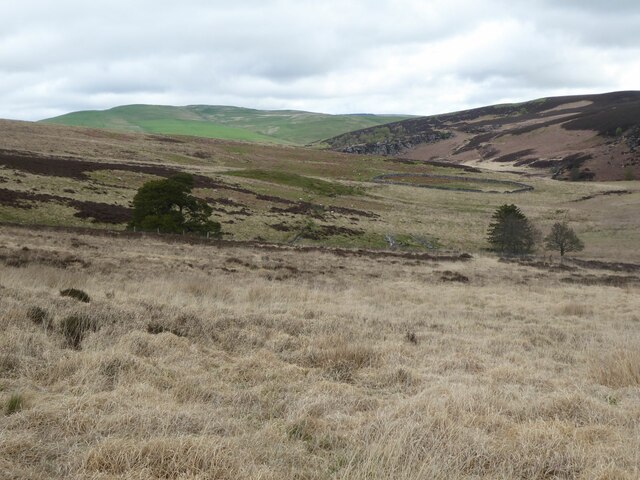
Ashy Pool is a picturesque freshwater marsh located in Northumberland, England. Nestled within the stunning landscape of Northumberland National Park, this natural gem is a haven for wildlife enthusiasts and nature lovers alike.

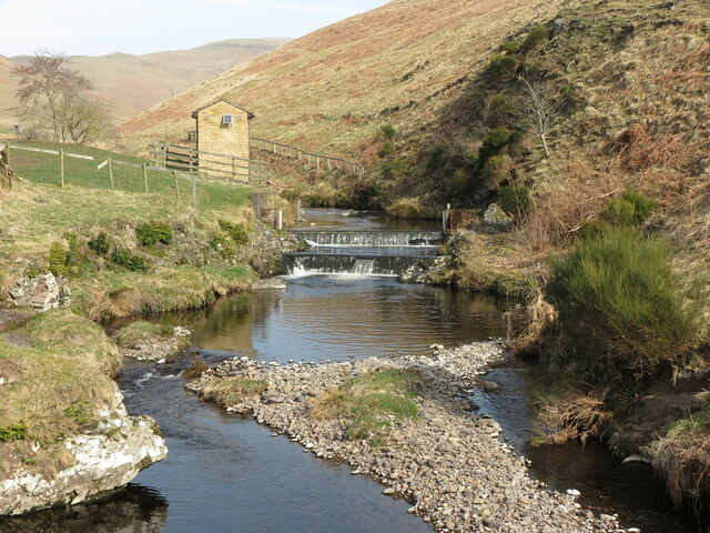
Covering an area of approximately 10 acres, Ashy Pool is characterized by its tranquil surroundings and diverse ecosystems. The pool itself is a small body of water, surrounded by lush vegetation and bordered by reed beds. The water is generally clear and shallow, providing a habitat for a variety of aquatic plants and organisms.

The pool is home to a wide range of bird species, making it a popular destination for birdwatchers. Visitors can spot common waterfowl such as mallards and coots, as well as rarer species like bitterns and reed warblers. The surrounding vegetation provides nesting grounds for various bird species, adding to the pool's avian diversity.

The pool is also inhabited by a variety of fish, including perch, pike, and roach. These fish species contribute to the overall ecosystem of Ashy Pool, supporting the diverse array of bird and plant life.

A wooden boardwalk has been constructed along the edge of the pool, allowing visitors to explore the area without disturbing the delicate marshland. Interpretive signs along the boardwalk provide information about the different species and habitats found within Ashy Pool, enhancing the educational experience for visitors.

Overall, Ashy Pool is a serene and ecologically significant site within Northumberland. Its unique blend of water, vegetation, and wildlife make it a must-visit destination for anyone seeking to immerse themselves in the beauty of nature.

If you have any feedback on the listing, please let us know in the comments section below.

Ashy Pool Images

Images are sourced within 2km of 55.354872/-2.170685 or Grid Reference NT8906. Thanks to Geograph Open Source API. All images are credited.

Waterfalls on the Usway Burn Taken from the eastern bank of the Usway Burn, this photo shows the map-marked waterfalls on this lovely watercourse. In the background is the bailey bridge better seen at <a title="https://www.geograph.org.uk/photo/6577029" href="https://www.geograph.org.uk/photo/6577029">Link</a>. For a selection of detailed free to download walking routes in the area visit <span class="nowrap"><a title="www.cheviotwalks.co.uk" rel="nofollow ugc noopener" href="http://www.cheviotwalks.co.uk">Link</a><img style="margin-left:2px;" alt="External link" title="External link - shift click to open in new window" src="https://s1.geograph.org.uk/img/external.png" width="10" height="10"/></span>
Waterfalls on the Usway Burn
Taken from the eastern bank of the Usway Burn, this photo shows the map-marked waterfalls on this lovely watercourse. In the background is the bailey bridge better seen at Link. For a selection of detailed free to download walking routes in the area visit LinkExternal link
Footbridge over Usway Burn This footbridge crosses from the eastern bank of the Usway Burn to the western bank giving access, via a Public Bridleway, to the farm at Shillmoor. It lies next to a concrete ford, and a matter of metres downstream the Usway Burn flows into the River Coquet. For a selection of detailed free to download walking routes in the area visit <span class="nowrap"><a title="www.cheviotwalks.co.uk" rel="nofollow ugc noopener" href="http://www.cheviotwalks.co.uk">Link</a><img style="margin-left:2px;" alt="External link" title="External link - shift click to open in new window" src="https://s1.geograph.org.uk/img/external.png" width="10" height="10"/></span>
Footbridge over Usway Burn
This footbridge crosses from the eastern bank of the Usway Burn to the western bank giving access, via a Public Bridleway, to the farm at Shillmoor. It lies next to a concrete ford, and a matter of metres downstream the Usway Burn flows into the River Coquet. For a selection of detailed free to download walking routes in the area visit LinkExternal link
Weir on the Usway Burn, Shillmoor Taken from the footbridge shown at <a title="https://www.geograph.org.uk/photo/7126257" href="https://www.geograph.org.uk/photo/7126257">Link</a> and looking upstream, this photo shows the weir at Shillmoor and an associated building (purpose unknown). For a selection of detailed free to download walking routes in the area visit <span class="nowrap"><a title="www.cheviotwalks.co.uk" rel="nofollow ugc noopener" href="http://www.cheviotwalks.co.uk">Link</a><img style="margin-left:2px;" alt="External link" title="External link - shift click to open in new window" src="https://s1.geograph.org.uk/img/external.png" width="10" height="10"/></span>
Weir on the Usway Burn, Shillmoor
Taken from the footbridge shown at Link and looking upstream, this photo shows the weir at Shillmoor and an associated building (purpose unknown). For a selection of detailed free to download walking routes in the area visit LinkExternal link
Footbridge over Wholehope Burn This is the same footbridge as is shown in my photo at <a title="https://www.geograph.org.uk/photo/3709042" href="https://www.geograph.org.uk/photo/3709042">Link</a> although taken from a different angle and at a different time of year. At the time of my original photo the bridge was relatively new and seemed to me to be quite intrusive. However, in the intervening 10 years it has weathered well and now blends nicely into the surrounding landscape. For a selection of detailed free to download walking routes in the area visit <span class="nowrap"><a title="www.cheviotwalks.co.uk" rel="nofollow ugc noopener" href="http://www.cheviotwalks.co.uk">Link</a><img style="margin-left:2px;" alt="External link" title="External link - shift click to open in new window" src="https://s1.geograph.org.uk/img/external.png" width="10" height="10"/></span>
Footbridge over Wholehope Burn
This is the same footbridge as is shown in my photo at Link although taken from a different angle and at a different time of year. At the time of my original photo the bridge was relatively new and seemed to me to be quite intrusive. However, in the intervening 10 years it has weathered well and now blends nicely into the surrounding landscape. For a selection of detailed free to download walking routes in the area visit LinkExternal link
Gate into Plantation This gate lies on the route of an old track known as the Pass Peth, a track which climbs diagonally up the steep hill seen ahead. The plantation, which wraps around the lower reaches of Passpeth Sike, consists entirely of deciduous trees. For a selection of detailed free to download walking routes in the area visit <span class="nowrap"><a title="www.cheviotwalks.co.uk" rel="nofollow ugc noopener" href="http://www.cheviotwalks.co.uk">Link</a><img style="margin-left:2px;" alt="External link" title="External link - shift click to open in new window" src="https://s1.geograph.org.uk/img/external.png" width="10" height="10"/></span>
Gate into Plantation
This gate lies on the route of an old track known as the Pass Peth, a track which climbs diagonally up the steep hill seen ahead. The plantation, which wraps around the lower reaches of Passpeth Sike, consists entirely of deciduous trees. For a selection of detailed free to download walking routes in the area visit LinkExternal link
Top of the Pass Peth The sac marks the 300 metre top of the Pass Peth with the River Coquet in the distance. In his 1903 book, 'Upper Coquetdale Northumberland Its History, Traditions, Folk-lore and Scenery', David Dippie Dixon described the Pass Peth as, "a perilous path, nothing more than a sheep track overlooking the linns, to be trod only by those possessed of a sure foot and clear head." He went on to say, " It was on these exposed heights that the men of Upper Coquet some three centuries ago had to keep watch, night and day, to guard against the incursions of the Scottish Freebooters". It certainly is a fine view. For a selection of detailed free to download walking routes in the area visit <span class="nowrap"><a title="www.cheviotwalks.co.uk" rel="nofollow ugc noopener" href="http://www.cheviotwalks.co.uk">Link</a><img style="margin-left:2px;" alt="External link" title="External link - shift click to open in new window" src="https://s1.geograph.org.uk/img/external.png" width="10" height="10"/></span>
Top of the Pass Peth
The sac marks the 300 metre top of the Pass Peth with the River Coquet in the distance. In his 1903 book, 'Upper Coquetdale Northumberland Its History, Traditions, Folk-lore and Scenery', David Dippie Dixon described the Pass Peth as, "a perilous path, nothing more than a sheep track overlooking the linns, to be trod only by those possessed of a sure foot and clear head." He went on to say, " It was on these exposed heights that the men of Upper Coquet some three centuries ago had to keep watch, night and day, to guard against the incursions of the Scottish Freebooters". It certainly is a fine view. For a selection of detailed free to download walking routes in the area visit LinkExternal link
Slippery Crags Looking towards the Kidland Forest.
Slippery Crags
Looking towards the Kidland Forest.
Sheepfold beside Linshiels Lake Not much used these days!
Sheepfold beside Linshiels Lake
Not much used these days!
Triangulation Pillar, Green Side Taken 13 years after my photo of the same pillar shown at <a title="https://www.geograph.org.uk/photo/1307363," href="https://www.geograph.org.uk/photo/1307363,">Link</a> but from a different angle, the top slice of the pillar now appears not to be such a neat fit to the lower portion. For a selection of detailed free to download walking routes in the area visit <span class="nowrap"><a title="www.cheviotwalks.co.uk" rel="nofollow ugc noopener" href="http://www.cheviotwalks.co.uk">Link</a><img style="margin-left:2px;" alt="External link" title="External link - shift click to open in new window" src="https://s1.geograph.org.uk/img/external.png" width="10" height="10"/></span>
Triangulation Pillar, Green Side
Taken 13 years after my photo of the same pillar shown at Link but from a different angle, the top slice of the pillar now appears not to be such a neat fit to the lower portion. For a selection of detailed free to download walking routes in the area visit LinkExternal link
Forest on Inner Hill Above Shillmoor in Upper Coquetdale.
Forest on Inner Hill
Above Shillmoor in Upper Coquetdale.
Drystone Wall on climb to Inner Hill This is yet another fine example of the art of drystone walling enclosing land behind Shillmoor Farm. For a selection of free to download detailed walking routes in the area visit <span class="nowrap"><a title="www.cheviotwalks.co.uk" rel="nofollow ugc noopener" href="http://www.cheviotwalks.co.uk">Link</a><img style="margin-left:2px;" alt="External link" title="External link - shift click to open in new window" src="https://s1.geograph.org.uk/img/external.png" width="10" height="10"/></span>
Drystone Wall on climb to Inner Hill
This is yet another fine example of the art of drystone walling enclosing land behind Shillmoor Farm. For a selection of free to download detailed walking routes in the area visit LinkExternal link
Corkscrew Falls On The River Coquet The River Coquet near Linbriggs.
Corkscrew Falls On The River Coquet
The River Coquet near Linbriggs.
The Cheviot Hills from the air The south end of the range around Linshiels and Shilmoor.
The Cheviot Hills from the air
The south end of the range around Linshiels and Shilmoor.
Rocky outcrop on the western flanks of Saugh Rigg This outcrop stands next to a thin footpath called the Pass Peth, an age-old path which follows the Usway Burn on its eastern side. This path appears to be little used as visitors to the valley seem to prefer the gravel track, a designated bridleway, on the opposite side of the burn. For a selection of detailed free to download walking routes in the area visit <span class="nowrap"><a title="www.cheviotwalks.co.uk" rel="nofollow ugc noopener" href="http://www.cheviotwalks.co.uk">Link</a><img style="margin-left:2px;" alt="External link" title="External link - shift click to open in new window" src="https://s1.geograph.org.uk/img/external.png" width="10" height="10"/></span>
Rocky outcrop on the western flanks of Saugh Rigg
This outcrop stands next to a thin footpath called the Pass Peth, an age-old path which follows the Usway Burn on its eastern side. This path appears to be little used as visitors to the valley seem to prefer the gravel track, a designated bridleway, on the opposite side of the burn. For a selection of detailed free to download walking routes in the area visit LinkExternal link
Downstream along the Coquet Looking downstream from just above Irving Pool.
Downstream along the Coquet
Looking downstream from just above Irving Pool.
Unusual roadside sign Roadside sign for an important archaeological site. The map shows a deserted medieval village site down near the river.
Unusual roadside sign
Roadside sign for an important archaeological site. The map shows a deserted medieval village site down near the river.
The tiny waterfall of Passpeth Sike In fact the waterfall is so small that one has to strain to see it. No doubt it would be more impressive after heavy rain.
The tiny waterfall of Passpeth Sike
In fact the waterfall is so small that one has to strain to see it. No doubt it would be more impressive after heavy rain.
Coquetdale view Looking up valley towards the farm at Shillmoor with Inner Hill rising towards Shillhope Law beyond.
Coquetdale view
Looking up valley towards the farm at Shillmoor with Inner Hill rising towards Shillhope Law beyond.
Show me another place!

Ashy Pool is located at Grid Ref: NT8906 (Lat: 55.354872, Lng: -2.170685)

Unitary Authority: Northumberland

Police Authority: Northumbria

What 3 Words

///friend.chuck.eggplants. Near Rochester, Northumberland

Nearby Locations

Ashy Pool Linbriggs

Related Wikis

Usway Burn

The Usway Burn is an upland river on the southern flanks of the Cheviot Hills, in the Northumberland National Park, England. It is a tributary of the River...

Barrow Meadow

Barrow Meadow is a Site of Special Scientific Interest (SSSI) in north Northumberland, England. The site is a species-rich hay meadow of a sort now rare...

Alwinton

Alwinton (previously named "Allenton" and sometimes still referred to as this) is a village and former parish in Northumberland, England. Alwinton is named...

River Alwin

The River Alwin is a short, steep upland river that drains the Kidland Forest on the southern flanks of the Cheviot Hills, in the Northumberland National...

Clennell, Northumberland

Clennell is a small village and as Clennel, a former civil parish, now in the parish of Alwinton, in Northumberland, England. It is about 1 mile (1.6 km...

Shillhope Law

Shillhope Law is a hill in the southern Cheviots, a range of hills in Northumberland, England. Shillhope Law is a relatively unremarkable member of this...

Clennell Hall

Clennell Hall is an historic manor house, now operated as a country hotel, situated at Clennell, near Alwinton, Northumberland, England. It is a Grade...

Harbottle Castle

Harbottle Castle is a ruined medieval castle situated at the west end of the village of Harbottle, Northumberland, England, 9 miles (14 km) west-north...

Nearby Amenities

Located within 500m of 55.354872,-2.170685
Barrier: cattle_grid
Lat/Long: 55.3523041/-2.1746456
old Linbrig Village
Historic: archaeological_site
Lat/Long: 55.3556738/-2.1694224
Barrier: cattle_grid
Lat/Long: 55.3510636/-2.1748481
Post Box
Collection Times: Mo-Fr 09:00; Sa 07:00
Post Box Design: waggon_top
Post Box Type: lamp
Ref: NE65 186D
Royal Cypher: GVIR
Royal Cypher Wikidata: Q33102169
Lat/Long: 55.3506981/-2.1717444
The data included in this document is from www.openstreetmap.org. The data is made available under ODbL.

Have you been to Ashy Pool?

Leave your review of Ashy Pool below (or comments, questions and feedback).